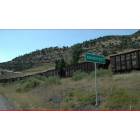
Somerset, Colorado
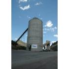
Somerset: Somerset Elevator
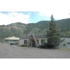
Somerset: Somerset Post Office
Somerset: Somerset Store
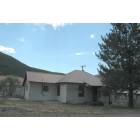
Somerset: Somerset House
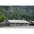
Somerset: Somerset Railroad
- add
your
Submit your own pictures of this place and show them to the world
- OSM Map
- General Map
- Google Map
- MSN Map

| Males: 285 | |
| Females: 237 |
| Median resident age: | 43.9 years |
| Colorado median age: | 34.3 years |
Zip code: 81623
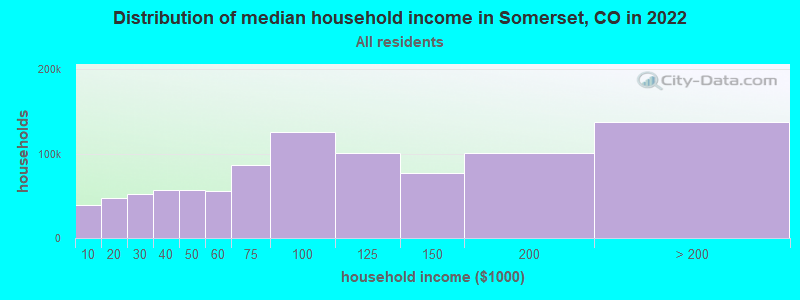
| Somerset: | $78,128 |
| CO: | $89,302 |
Estimated per capita income in 2022: $57,886 (it was $27,070 in 2000)
Somerset CCD income, earnings, and wages data
Estimated median house or condo value in 2022: $655,982 (it was $195,000 in 2000)
| Somerset: | $655,982 |
| CO: | $531,100 |
Mean prices in 2022: all housing units: $759,705; detached houses: $829,821; townhouses or other attached units: $594,912; in 2-unit structures: $452,031; in 3-to-4-unit structures: $449,680; in 5-or-more-unit structures: $536,429; mobile homes: $177,135
Detailed information about poverty and poor residents in Somerset, CO


- 45793.6%White alone
- 204.1%Hispanic
- 40.8%American Indian alone
- 40.8%Asian alone
- 10.2%Black alone
- 10.2%Native Hawaiian and Other
Pacific Islander alone - 10.2%Two or more races

 Recent articles from our blog. Our writers, many of them Ph.D. graduates or candidates, create easy-to-read articles on a wide variety of topics.
Current Local Time: MST time zone
Elevation: 6042 feet
Land area: 673.5 square miles.
Population density: 0.8 people per square mile (very low).

| Somerset CCD: | 0.4% ($725) |
| Colorado: | 0.7% ($1,132) |
Nearest city with pop. 50,000+: Lakewood, CO  (129.0 miles , pop. 144,126).
Nearest city with pop. 200,000+: Northeast Jefferson, CO (129.8 miles , pop. 450,166).
Nearest city with pop. 1,000,000+: Phoenix, AZ (460.8 miles , pop. 1,321,045).
Nearest cities:
Latitude: 38.98 N, Longitude: 107.32 W
Area code: 970

| Here: | 2.3% |
| Colorado: | 3.2% |
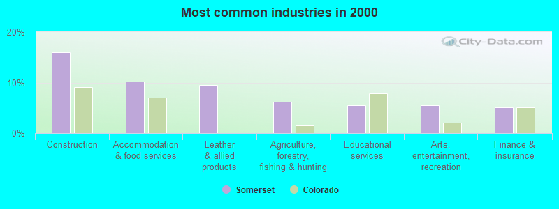
- Construction (16.1%)
- Accommodation & food services (10.2%)
- Leather & allied products (9.5%)
- Agriculture, forestry, fishing & hunting (6.2%)
- Educational services (5.5%)
- Arts, entertainment, recreation (5.5%)
- Finance & insurance (5.1%)
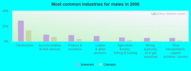
- Construction (27.7%)
- Accommodation & food services (9.4%)
- Finance & insurance (8.8%)
- Leather & allied products (7.5%)
- Agriculture, forestry, fishing & hunting (5.7%)
- Mining, quarrying, oil & gas extraction (5.0%)
- Other transportation, support activities, couriers (5.0%)
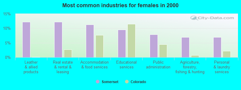
- Leather & allied products (12.2%)
- Real estate & rental & leasing (12.2%)
- Accommodation & food services (11.3%)
- Educational services (9.6%)
- Public administration (7.8%)
- Agriculture, forestry, fishing & hunting (7.0%)
- Personal & laundry services (7.0%)
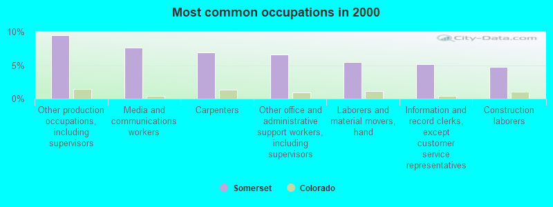
- Other production occupations, including supervisors (9.5%)
- Media and communications workers (7.7%)
- Carpenters (6.9%)
- Other office and administrative support workers, including supervisors (6.6%)
- Laborers and material movers, hand (5.5%)
- Information and record clerks, except customer service representatives (5.1%)
- Construction laborers (4.7%)
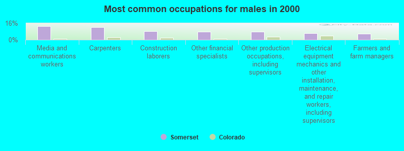
- Media and communications workers (13.2%)
- Carpenters (11.9%)
- Construction laborers (8.2%)
- Other financial specialists (7.5%)
- Other production occupations, including supervisors (7.5%)
- Electrical equipment mechanics and other installation, maintenance, and repair workers, including supervisors (6.3%)
- Farmers and farm managers (5.7%)
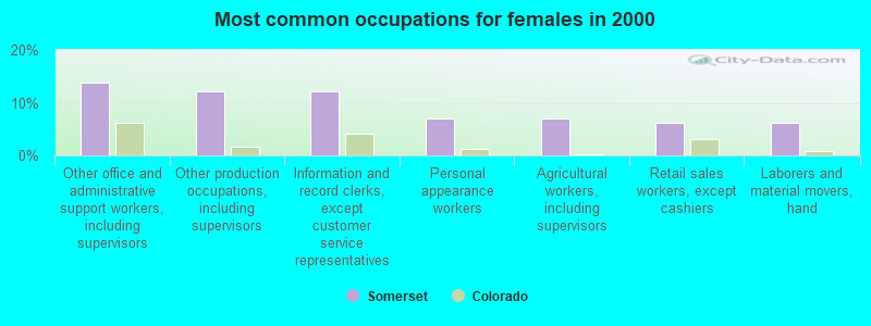
- Other office and administrative support workers, including supervisors (13.9%)
- Other production occupations, including supervisors (12.2%)
- Information and record clerks, except customer service representatives (12.2%)
- Personal appearance workers (7.0%)
- Agricultural workers, including supervisors (7.0%)
- Retail sales workers, except cashiers (6.1%)
- Laborers and material movers, hand (6.1%)
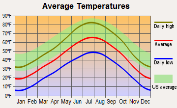
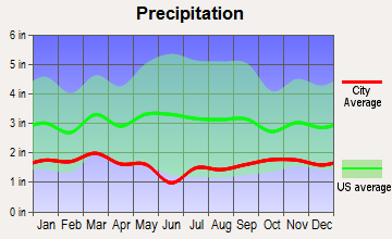
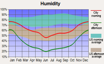
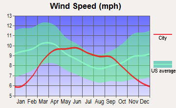
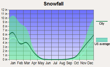
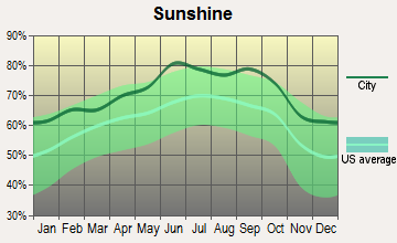
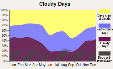
Average climate in Somerset, Colorado
Based on data reported by over 4,000 weather stations
(lower is better)
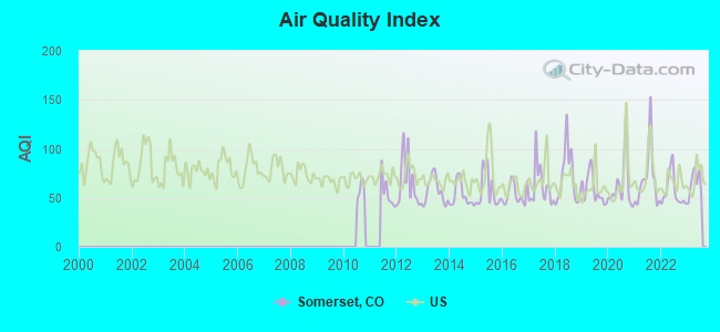
Air Quality Index (AQI) level in 2023 was 64.8. This is about average.
| City: | 64.8 |
| U.S.: | 72.6 |

Nitrogen Dioxide (NO2) [ppb] level in 2021 was 1.66. This is significantly better than average. Closest monitor was 16.6 miles away from the city center.
| City: | 1.66 |
| U.S.: | 5.11 |
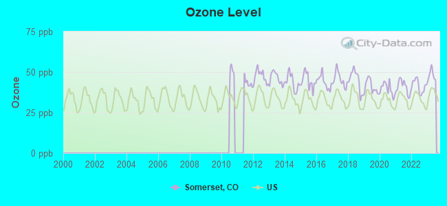
Ozone [ppb] level in 2023 was 48.1. This is significantly worse than average. Closest monitor was 8.9 miles away from the city center.
| City: | 48.1 |
| U.S.: | 33.3 |
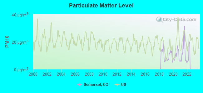
Particulate Matter (PM10) [µg/m3] level in 2021 was 11.9. This is significantly better than average. Closest monitor was 16.6 miles away from the city center.
| City: | 11.9 |
| U.S.: | 19.2 |
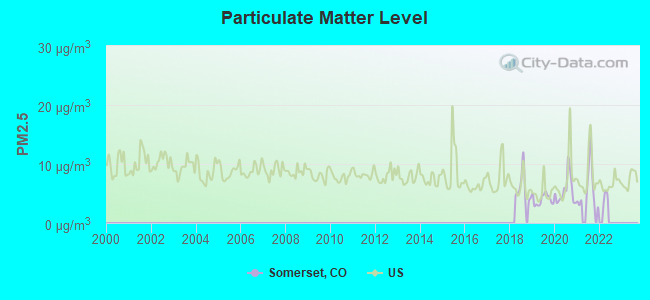
Particulate Matter (PM2.5) [µg/m3] level in 2021 was 5.92. This is better than average. Closest monitor was 16.6 miles away from the city center.
| City: | 5.92 |
| U.S.: | 8.11 |
Earthquake activity:
Somerset-area historical earthquake activity is significantly above Colorado state average. It is 1120% greater than the overall U.S. average.On 8/18/1959 at 06:37:13, a magnitude 7.7 (7.7 UK, Class: Major, Intensity: VIII - XII) earthquake occurred 422.6 miles away from the city center, causing $26,000,000 total damage
On 10/28/1983 at 14:06:06, a magnitude 7.3 (6.2 MB, 7.3 MS, 7.0 MW) earthquake occurred 486.2 miles away from Somerset center, causing 2 deaths (2 shaking deaths) and 3 injuries, causing $15,000,000 total damage
On 10/3/1915 at 06:52:48, a magnitude 7.6 (7.6 UK) earthquake occurred 551.0 miles away from the city center
On 3/28/1975 at 02:31:05, a magnitude 6.2 (6.1 MB, 6.0 MS, 6.2 ML, Class: Strong, Intensity: VII - IX) earthquake occurred 342.4 miles away from the city center
On 8/23/2011 at 05:46:18, a magnitude 5.3 (5.3 MW, Depth: 2.5 mi, Class: Moderate, Intensity: VI - VII) earthquake occurred 195.0 miles away from Somerset center
On 3/18/2020 at 13:09:31, a magnitude 5.7 (5.7 MW, Depth: 7.4 mi) earthquake occurred 280.4 miles away from the city center
Magnitude types: body-wave magnitude (MB), local magnitude (ML), surface-wave magnitude (MS), moment magnitude (MW)
Natural disasters:
The number of natural disasters in Gunnison County (8) is smaller than the US average (15).Major Disasters (Presidential) Declared: 3
Emergencies Declared: 3
Causes of natural disasters: Fires: 2, Floods: 2, Landslides: 2, Drought: 1, Hurricane: 1, Mudslide: 1, Snowstorm: 1, Storm: 1, Other: 1 (Note: some incidents may be assigned to more than one category).
Colleges/universities with over 2000 students nearest to Somerset:
- Western State Colorado University (about 38 miles; Gunnison, CO; Full-time enrollment: 2,023)
- Colorado Mountain College (about 40 miles; Glenwood Springs, CO; FT enrollment: 3,463)
- Colorado Mesa University (about 66 miles; Grand Junction, CO; FT enrollment: 7,671)
- Fort Lewis College (about 122 miles; Durango, CO; FT enrollment: 3,631)
- Colorado School of Mines (about 125 miles; Golden, CO; FT enrollment: 5,507)
- Red Rocks Community College (about 128 miles; Lakewood, CO; FT enrollment: 6,185)
- Colorado Christian University (about 130 miles; Lakewood, CO; FT enrollment: 2,959)
Points of interest:
Notable locations in Somerset: Davenport Ranch (A), Navajo Cabin (B), Little Robinson Cow Camp (C), Lost Lake Campground (D), Slide Down (E), Hawks Nest Ranch (F), Lands End Overlook Picnic Ground (G), Upper Cow Camp (H), Minnesota Cow Camp (I), McClure Campground (J), Lake Irwin Campground (K), Cockroft Cow Camp (L), Lily Lake Forest Service Facility (M), Snowshoe Cow Camp (N), Olson Place (O), Tolan Place (P), Brown Cow Camp (Q), Hotchkiss Sheep Camp (R), Jacobs Ranch (S), Bogan Flats Campground (T). Display/hide their locations on the map
Church in Somerset: Marble Community Church (A). Display/hide its location on the map
Cemeteries: Marble Cemetery (1), Somerset Cemetery (2), Irwin Cemetery (3). Display/hide their locations on the map
Lakes, reservoirs, and swamps: Flogus Pond (A), Floating Lake (B), Island Lake (C), Lizard Lake (D), Lily Lake (E), Yule Lakes (F), Little Gem Lake (G), Snowfield Lake (H). Display/hide their locations on the map
Streams, rivers, and creeks: North Fork Crystal River (A), South Fork Crystal River (B), Raspberry Creek (C), Yule Creek (D), Milton Creek (E), Carbonate Creek (F), Slate Creek (G), Williams Creek (H), Dugout Creek (I). Display/hide their locations on the map
Parks in Somerset include: Paonia Reservoir State Recreation Area (1), Marble Mill Site Park (2). Display/hide their locations on the map
Tourist attraction: Bar ZX Ranch & Lodge (Tours & Charters; 15700 County Road 77) (1). Display/hide its approximate location on the map
| This place: | 2.1 people |
| Colorado: | 2.5 people |
| This place: | 59.4% |
| Whole state: | 63.9% |
| This place: | 6.7% |
| Whole state: | 6.5% |
Likely homosexual households (counted as self-reported same-sex unmarried-partner households)
- Lesbian couples: 0.0% of all households
- Gay men: 0.4% of all households
| This place: | 10.1% |
| Whole state: | 9.3% |
| This place: | 5.5% |
| Whole state: | 4.1% |
5 people in workers' group living quarters and job corps centers in 2010
For population 15 years and over in Somerset:
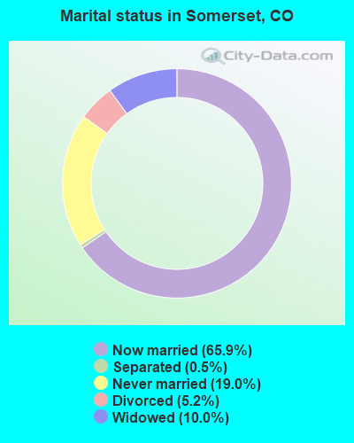
- Never married: 19.0%
- Now married: 65.9%
- Separated: 0.5%
- Widowed: 10.0%
- Divorced: 5.2%
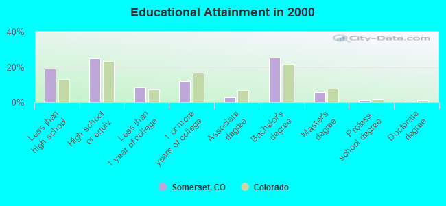
For population 25 years and over in Somerset:
- High school or higher: 81.0%
- Bachelor's degree or higher: 32.5%
- Graduate or professional degree: 7.4%
- Unemployed: 6.8%
- Mean travel time to work (commute): 33.4 minutes
| Here: | 12.7 |
| Colorado average: | 11.8 |
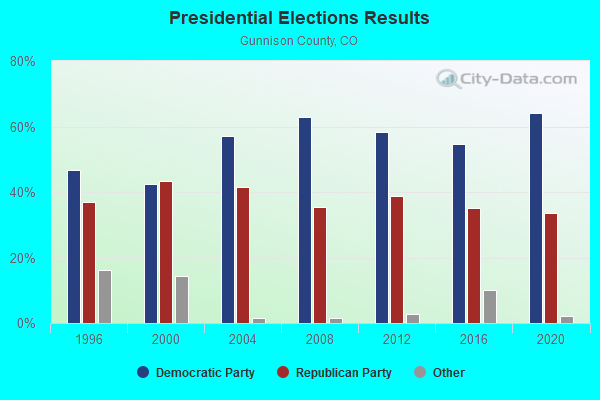
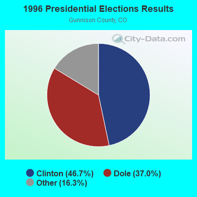

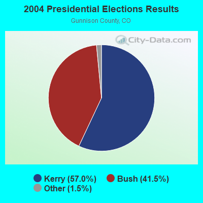
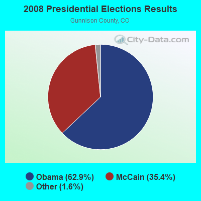

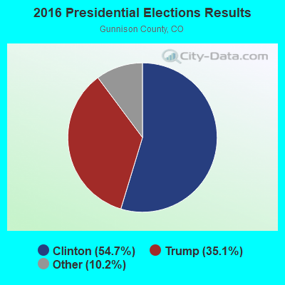
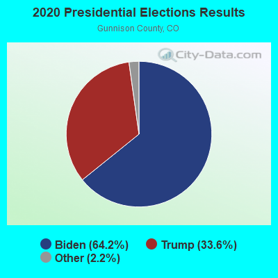
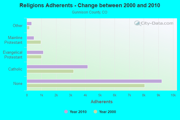
Graphs represent county-level data. Detailed 2008 Election Results
Religion statistics for Somerset, CO (based on Gunnison County data)
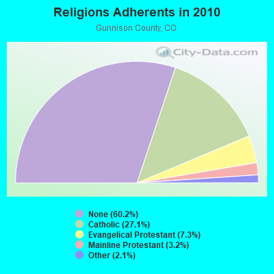
| Religion | Adherents | Congregations |
|---|---|---|
| Catholic | 4,157 | 2 |
| Evangelical Protestant | 1,121 | 12 |
| Mainline Protestant | 491 | 4 |
| Other | 326 | 3 |
| None | 9,229 | - |
Food Environment Statistics:
| This county: | 3.35 / 10,000 pop. |
| Colorado: | 1.50 / 10,000 pop. |
| This county: | 1.34 / 10,000 pop. |
| State: | 0.45 / 10,000 pop. |
| This county: | 3.35 / 10,000 pop. |
| Colorado: | 3.13 / 10,000 pop. |
| Gunnison County: | 30.12 / 10,000 pop. |
| Colorado: | 8.99 / 10,000 pop. |
| Gunnison County: | 3.7% |
| State: | 5.3% |
| This county: | 15.2% |
| Colorado: | 18.4% |
| Gunnison County: | 8.7% |
| State: | 9.6% |
Strongest AM radio stations in Somerset:
- KNZZ (1100 AM; 50 kW; GRAND JUNCTION, CO; Owner: M B C GRAND BROADCASTING, INC.)
- KUBC (580 AM; 5 kW; MONTROSE, CO; Owner: WOODLAND COMMUNICATIONS CORPORATION)
- KJOL (620 AM; 10 kW; GRAND JUNCTION, CO; Owner: UNITED MINISTRIES)
- KLTT (670 AM; 50 kW; COMMERCE CITY, CO; Owner: KLZ RADIO, INC.)
- KKZN (760 AM; 50 kW; THORNTON, CO; Owner: JACOR BROADCASTING OF COLORADO, INC.)
- KOA (850 AM; 50 kW; DENVER, CO; Owner: JACOR BROADCASTING OF COLORADO, INC.)
- KMXA (1090 AM; 50 kW; AURORA, CO; Owner: ENTRAVISION HOLDINGS, LLC)
- KSKE (610 AM; 5 kW; VAIL, CO; Owner: PILGRIM COMMUNICATIONS, INC.)
- KLMO (1060 AM; 30 kW; LONGMONT, CO; Owner: PILGRIM COMMUNICATIONS, INC.)
- KTNN (660 AM; 50 kW; WINDOW ROCK, AZ; Owner: THE NAVAJO NATION)
- KKOB (770 AM; 50 kW; ALBUQUERQUE, NM; Owner: CITADEL BROADCASTING COMPANY)
- KCUV (1510 AM; 25 kW; LITTLETON, CO; Owner: PEOPLE WIRELESS, INC.)
- KALL (700 AM; 50 kW; NORTH SALT LAKE CITY, UT; Owner: CITICASTERS LICENSES, L.P.)
Strongest FM radio stations in Somerset:
- KDNK (90.5 FM; CARBONDALE, CO; Owner: CARBONDALE COMM. ACCESS RADIO, INC.)
- K247AD (97.3 FM; CARBONDALE, CO; Owner: PITKIN COUNTY TRANSLATOR)
- KLXV (91.9 FM; GLENWOOD SPRINGS, CO; Owner: EDUCATIONAL MEDIA FOUNDATION)
- KRVG (95.5 FM; GLENWOOD SPRINGS, CO; Owner: WESTERN SLOPE COMMUNICATIONS LLC)
- KZKS-FM2 (105.3 FM; CARBONDALE, CO; Owner: WESTERN SLOPE COMMUNICATIONS, L.L.C)
- KKCH (92.7 FM; GLENWOOD SPRINGS, CO; Owner: AGM-ROCKY MOUNTAIN BROADCASTING I, L.L.C.)
- K256AD (99.1 FM; PALISADE, CO; Owner: NORTH FORK VALLEY PUBLIC RADIO, INC.)
- K205CK (88.9 FM; GRAND JUNCTION, CO; Owner: CALVARY CHAPEL OF TWIN FALLS, INC.)
- K214CA (90.7 FM; GRAND JUNCTION, CO; Owner: FAMILY STATIONS, INC.)
- K210CE (89.9 FM; MESA, CO; Owner: EDUCATIONAL MEDIA FOUNDATION)
- KZKS (105.3 FM; RIFLE, CO; Owner: WESTERN SLOPE COMMUNICATIONS, L.L.C.)
- KKXK (94.1 FM; MONTROSE, CO; Owner: WOODLAND COMMUNICATIONS CORPORATION)
- KWGL (105.7 FM; OURAY, CO; Owner: WS COMMUNICATIONS, L.L.C.)
- KPRH (88.3 FM; MONTROSE, CO; Owner: PUBLIC BROADCASTING OF COLORADO INC)
- K259AC (99.7 FM; GYPSUM, ETC., CO; Owner: COMMUNITY RADIO FOR NORTHERN COLORADO)
- KBNG (103.7 FM; RIDGWAY, CO; Owner: WOODLAND COMMUNICATIONS CORPORATION)
- KTUN (101.5 FM; EAGLE, CO; Owner: SALISBURY BROADCASTING COLORADO, LLC)
- K276AI (103.1 FM; RIFLE, CO; Owner: MBC GRAND BROADCASTING, INC.)
- KPVW (107.1 FM; ASPEN, CO; Owner: ENTRAVISION HOLDINGS, LLC)
- KKNN (95.1 FM; DELTA, CO; Owner: CUMULUS LICENSING CORP.)
FCC Registered Private Land Mobile Towers:
1- 1 Mi E (Lat: 38.929167 Lon: -107.446167), Type: Building, Structure height: 2 m, Overall height: 3 m, Call Sign: WPPH316,
Assigned Frequencies: 913.000 MHz, 918.150 MHz, Grant Date: 12/18/2014, Expiration Date: 12/22/2024, Certifier: Robert Turner, Registrant: Dorsey & Whitney, L.L.P., 50 South Sixth Street, Suite 1500, Minneapolis, MN 55402, Phone: (612) 492-6185, Fax: (612) 545-4183, Email:
FCC Registered Broadcast Land Mobile Towers:
5- West Elk Coal Co 3 Mi E On Co Hwy 133 (Lat: 38.926667 Lon: -107.447556), Call Sign: KNHA311, Licensee ID: L00160062,
Assigned Frequencies: 151.520 MHz, Grant Date: 09/21/2022, Expiration Date: 12/16/2032, Certifier: Robert P Turner, Registrant: Mountain Coal Co LLC
- Oxbow Coal Loadout N Of Hwy 133 (Lat: 38.930278 Lon: -107.462278), Type: Building, Structure height: 9 m, Overall height: 11 m, Call Sign: WPRT935,
Assigned Frequencies: 161.490 MHz, 161.550 MHz, Grant Date: 01/23/2016, Expiration Date: 01/26/2026, Certifier: L J Kopiasz, Registrant: Prokarma, 222 So 15th St., Suite 505n, Omaha, NE 68102, Phone: (402) 522-5068, Fax: (402) 346-6676, Email:
- MP 92.0 NORTH FORK S, Mp 92.0, 1.0 Mi Sw Of Somerset (Lat: 38.923889 Lon: -107.484722), Type: Mast, Structure height: 4 m, Call Sign: WPWF417,
Assigned Frequencies: 161.550 MHz, 161.565 MHz, Grant Date: 10/25/2012, Expiration Date: 11/04/2022, Cancellation Date: 01/15/2013, Certifier: Larry J Kopiasz, Registrant: Union Pacific Railroad Company, 1400 Douglas St Stop 0650, Omaha, NE 68179, Phone: (402) 544-6090, Fax: (402) 233-2025, Email:
- Lat: 38.963250 Lon: -107.310833, Call Sign: WQHN881,
Assigned Frequencies: 464.887 MHz, 463.637 MHz, 464.612 MHz, Grant Date: 10/26/2017, Expiration Date: 09/24/2027, Certifier: William Koch, Registrant: Federal License Management, 175 Pine St, Suite 104, Williamsport, PA 17701-6549, Phone: (866) 908-2220, Fax: (570) 323-4002, Email:
- MP 91.8, Mp 91.8 (Lat: 38.921722 Lon: -107.488194), Type: Bant, Structure height: 4 m, Call Sign: WQPX438,
Assigned Frequencies: 161.550 MHz, 161.565 MHz, Grant Date: 08/06/2022, Expiration Date: 09/10/2032, Certifier: Thomas J Mcgovern, Registrant: Concentrix, 222 So 15th St. Suite 505 N, Omaha, NE 68102, Phone: (402) 522-5068, Email:
FCC Registered Amateur Radio Licenses:
3- Call Sign: KB0SNG, Grant Date: 05/10/1995, Expiration Date: 05/10/2005, Cancellation Date: 05/11/2007, Registrant: Robert D Smith, 27862 Co Rd 12, Somerset, CO 81434-9601
- Call Sign: N0MVA, Licensee ID: L00276953, Grant Date: 05/20/1999, Expiration Date: 11/19/2001, Cancellation Date: 09/01/2000, Registrant: Scott Mc Intire, Somerset, CO 81434-0555
- Call Sign: N0WLI, Licensee ID: L00281381, Grant Date: 04/27/1993, Expiration Date: 04/27/2003, Cancellation Date: 09/23/2000, Registrant: Kathryn S Mc Intire, Somerset, CO 81434
FAA Registered Aircraft:
1- Aircraft: EUROCOPTER EC 130 B4 (Category: Land, Seats: 6, Weight: 12,500 - 19,999 Pounds), Engine: TURBOMECA ARRIEL 2B1 (747 HP) (Turbo-shaft)
N-Number: 974BR, N974BR, N-974BR, Serial Number: 4672, Year manufactured: 2009, Airworthiness Date: 06/29/2009, Certificate Issue Date: 05/21/2012
Registrant (Corporation): Jayhawk Inc, 30682 County Road 12, Somerset, CO 81434
Deregistered: Cancel Date: 06/15/2018, Exported to: Australia
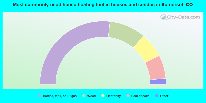
- 53.6%Bottled, tank, or LP gas
- 18.6%Wood
- 12.9%Electricity
- 12.1%Coal or coke
- 1.4%Utility gas
- 1.4%Solar energy
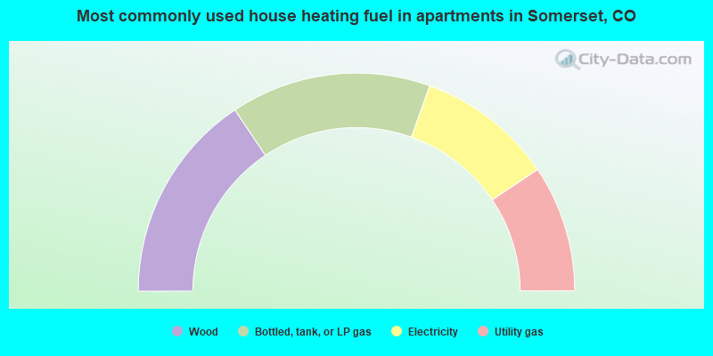
- 31.2%Wood
- 29.7%Bottled, tank, or LP gas
- 20.3%Electricity
- 18.8%Utility gas
Somerset compared to Colorado state average:
- Unemployed percentage below state average.
- Black race population percentage significantly below state average.
- Hispanic race population percentage significantly below state average.
- Median age above state average.
- Foreign-born population percentage significantly below state average.
- Length of stay since moving in significantly above state average.
- Number of rooms per house significantly below state average.
- House age significantly below state average.
- Number of college students below state average.