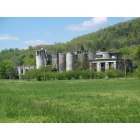
Sherwood, Tennessee
Submit your own pictures of this place and show them to the world
- OSM Map
- General Map
- Google Map
- MSN Map

| Males: 269 | |
| Females: 289 |
| Median resident age: | 43.0 years |
| Tennessee median age: | 35.9 years |
Zip code: 37376
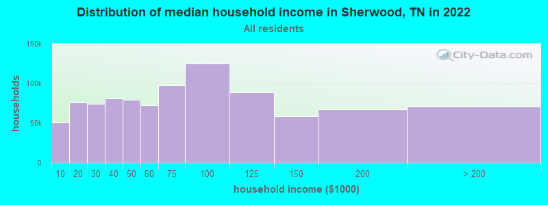
| Sherwood: | $39,458 |
| TN: | $65,254 |
Estimated per capita income in 2022: $19,418 (it was $10,924 in 2000)
Sherwood CCD income, earnings, and wages data
Estimated median house or condo value in 2022: $97,437 (it was $33,100 in 2000)
| Sherwood: | $97,437 |
| TN: | $284,800 |
Detailed information about poverty and poor residents in Sherwood, TN
Compare current foreclosures near Sherwood, TN:
| Photo | Address | Area | Beds / Baths | Price | Details |
|---|---|---|---|---|---|

|
#1
Mountain Ave W
Sherwood, TN 37376
|
- sq. feet
|
- baths - beds |
show details | |

|
#2
N West St
Decherd, TN 37324
|
1,742 sq. feet
|
2 baths 4 beds |
show details | |

|
#3
Sweetens Cove Rd
South Pittsburg, TN 37380
|
1,650 sq. feet
|
2 baths 2 beds |
show details | |

|
#4
Jackson St
Cowan, TN 37318
|
1,314 sq. feet
|
2 baths 4 beds |
show details | |

|
#5
Garner St
Cowan, TN 37318
|
- sq. feet
|
2 baths 3 beds |
show details | |

|
#6
Brandi Way
Winchester, TN 37398
|
3,802 sq. feet
|
3 baths - beds |
show details | |

|
#7
Woods Edge Rd
Winchester, TN 37398
|
1,511 sq. feet
|
2 baths - beds |
show details | |

|
#8
S Shephard St
Winchester, TN 37398
|
1,566 sq. feet
|
1 baths - beds |
show details | |

|
#9
Spring St
Decherd, TN 37324
|
1,480 sq. feet
|
1 baths - beds |
show details | |

|
#10
Swann Ln
Decherd, TN 37324
|
1,300 sq. feet
|
1 baths - beds |
show details |
| Photo | Address | Area | Beds / Baths | Price | Details |
|---|---|---|---|---|---|

|
#11
Powell St
Decherd, TN 37324
|
1,064 sq. feet
|
2 baths - beds |
show details | |

|
#12
Highway 150
Sequatchie, TN 37374
|
1,344 sq. feet
|
1 baths - beds |
show details | |

|
#13
Deepwoods Rd
Sewanee, TN 37375
|
2,580 sq. feet
|
4 baths - beds |
show details | |

|
#14
Rotary Dr
Winchester, TN 37398
|
1,120 sq. feet
|
2 baths - beds |
show details | |

|
#15
Goodman Rd
Pelham, TN 37366
|
960 sq. feet
|
1 baths - beds |
show details | |

|
#16
Gail Ln
Jasper, TN 37347
|
900 sq. feet
|
2 baths - beds |
show details | |

|
#17
W Broad St
Decherd, TN 37324
|
1,568 sq. feet
|
1 baths - beds |
show details | |

|
#18
13th Ave NW
Winchester, TN 37398
|
2,047 sq. feet
|
3 baths - beds |
show details | |

|
#19
Alabama Ave
Bridgeport, AL 35740
|
1,392 sq. feet
|
2 baths - beds |
show details | |

|
#20
S Pittsburg Mountain Rd
Sewanee, TN 37375
|
2,576 sq. feet
|
2 baths - beds |
show details |
| Photo | Address | Area | Beds / Baths | Price | Details |
|---|---|---|---|---|---|

|
#21
N 2nd St
Decherd, TN 37324
|
1,340 sq. feet
|
1 baths - beds |
show details | |

|
#22
Main St
Jasper, TN 37347
|
1,073 sq. feet
|
1 baths - beds |
show details | |

|
#23
Old Alto Hwy
Decherd, TN 37324
|
960 sq. feet
|
1 baths - beds |
show details | |

|
#24
View St
Jasper, TN 37347
|
3,281 sq. feet
|
1 baths - beds |
show details | |

|
#25
1st Ave
Jasper, TN 37347
|
1,566 sq. feet
|
1 baths - beds |
show details | |

|
#26
Bible Crossing Rd
Winchester, TN 37398
|
1,446 sq. feet
|
2 baths - beds |
show details | |

|
#27
Woodland Dr
Decherd, TN 37324
|
1,596 sq. feet
|
2 baths - beds |
show details | |

|
#28
Laurel Ave
South Pittsburg, TN 37380
|
1,645 sq. feet
|
1 baths - beds |
show details | |

|
#29
Putnam Ave
South Pittsburg, TN 37380
|
2,498 sq. feet
|
1 baths - beds |
show details | |

|
#30
Highland Ave
Jasper, TN 37347
|
864 sq. feet
|
1 baths - beds |
show details |
| Photo | Address | Area | Beds / Baths | Price | Details |
|---|---|---|---|---|---|

|
#31
Sweetens Cove Rd
South Pittsburg, TN 37380
|
1,960 sq. feet
|
1 baths - beds |
show details | |

|
#32
Haddon Ln
Winchester, TN 37398
|
896 sq. feet
|
1 baths - beds |
show details | |

|
#33
Roys Ln
Winchester, TN 37398
|
1,300 sq. feet
|
2 baths - beds |
show details | |

|
#34
S Pittsburg Mountain Rd
South Pittsburg, TN 37380
|
1,008 sq. feet
|
1 baths - beds |
show details | |

|
#35
Sequatchie Mountain Rd
Sequatchie, TN 37374
|
1,068 sq. feet
|
2 baths - beds |
show details | |

|
#36
Mayfair Ave
Jasper, TN 37347
|
1,489 sq. feet
|
2 baths - beds |
show details | |

|
#37
Patton School Rd
South Pittsburg, TN 37380
|
1,056 sq. feet
|
2 baths - beds |
show details | |

|
#38
Foster Falls Rd
Sequatchie, TN 37374
|
1,176 sq. feet
|
2 baths - beds |
show details | |

|
#39
2nd St
South Pittsburg, TN 37380
|
1,381 sq. feet
|
1 baths - beds |
show details | |

|
#40
Pryor Cove Rd
Jasper, TN 37347
|
1,392 sq. feet
|
2 baths - beds |
show details |
| Photo | Address | Area | Beds / Baths | Price | Details |
|---|---|---|---|---|---|

|
#41
Marion Ave
South Pittsburg, TN 37380
|
1,768 sq. feet
|
1 baths - beds |
show details | |

|
#42
Laurel Ave
South Pittsburg, TN 37380
|
1,025 sq. feet
|
1 baths - beds |
show details | |

|
#43
9th Ave NW
Winchester, TN 37398
|
- sq. feet
|
- baths - beds |
show details | |

|
#44
Jacobs Ave
Bridgeport, AL 35740
|
1,112 sq. feet
|
- baths - beds |
show details | |

|
#45
Roarks Cove Rd
Decherd, TN 37324
|
1,976 sq. feet
|
- baths - beds |
show details | |

|
#46
Pryor Cove Rd
Jasper, TN 37347
|
- sq. feet
|
- baths - beds |
show details | |

|
#47
Country Estates Dr
Winchester, TN 37398
|
- sq. feet
|
- baths - beds |
show details | |

|
#48
Moore Ave
Bridgeport, AL 35740
|
- sq. feet
|
- baths - beds |
show details | |

|
#49
Oliver Ln
Monteagle, TN 37356
|
- sq. feet
|
- baths - beds |
show details | |

|
Check over 1 million property listings on Foreclosure.com!
|
browse all offers | |||

- 51897.2%White alone
- 101.9%Two or more races
- 50.9%Hispanic
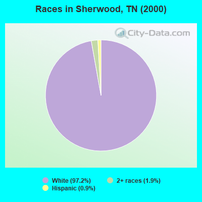
Races in Sherwood detailed stats: ancestries, foreign born residents, place of birth
According to our research of Tennessee and other state lists, there was 1 registered sex offender living in Sherwood, Tennessee as of May 10, 2024.
The ratio of all residents to sex offenders in Sherwood is 558 to 1.
The ratio of registered sex offenders to all residents in this city is lower than the state average.
 Recent articles from our blog. Our writers, many of them Ph.D. graduates or candidates, create easy-to-read articles on a wide variety of topics.
Current Local Time: CST time zone
Elevation: 672 feet
Land area: 87.2 square miles.
Population density: 6.4 people per square mile (very low).

| Sherwood CCD: | 1.0% ($331) |
| Tennessee: | 0.8% ($715) |
Nearest city with pop. 50,000+: Chattanooga, TN  (37.1 miles , pop. 155,554).
Nearest city with pop. 200,000+: Nashville-Davidson, TN (89.2 miles , pop. 545,524).
Nearest city with pop. 1,000,000+: Chicago, IL (478.5 miles , pop. 2,896,016).
Nearest cities:
), Latitude: 35.06 N, Longitude: 85.92 W
Area code commonly used in this area: 931

| Here: | 3.3% |
| Tennessee: | 3.0% |
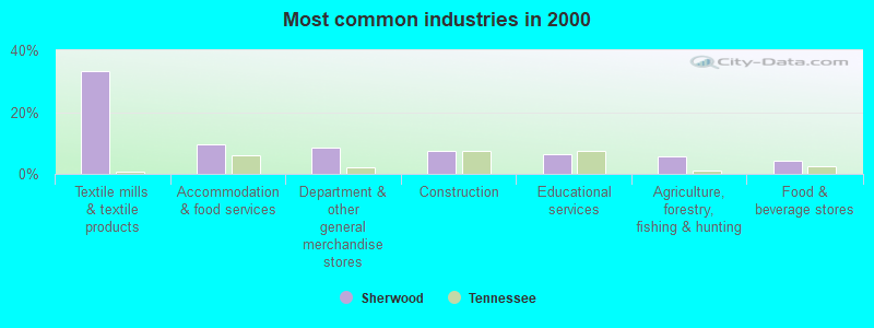
- Textile mills & textile products (33.3%)
- Accommodation & food services (9.5%)
- Department & other general merchandise stores (8.3%)
- Construction (7.5%)
- Educational services (6.3%)
- Agriculture, forestry, fishing & hunting (5.6%)
- Food & beverage stores (4.4%)
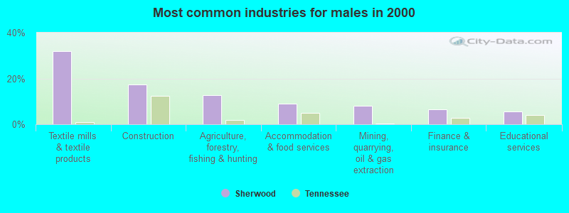
- Textile mills & textile products (31.8%)
- Construction (17.3%)
- Agriculture, forestry, fishing & hunting (12.7%)
- Accommodation & food services (9.1%)
- Mining, quarrying, oil & gas extraction (8.2%)
- Finance & insurance (6.4%)
- Educational services (5.5%)
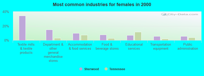
- Textile mills & textile products (34.5%)
- Department & other general merchandise stores (14.8%)
- Accommodation & food services (9.9%)
- Food & beverage stores (7.7%)
- Educational services (7.0%)
- Transportation equipment (5.6%)
- Public administration (5.6%)
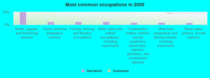
- Textile, apparel, and furnishings workers (31.7%)
- Cooks and food preparation workers (7.9%)
- Fishing, hunting, and forestry occupations (7.9%)
- Other sales and related occupations, including supervisors (7.5%)
- Construction traders workers except carpenters, electricians, painters, plumbers, and construction laborers (6.0%)
- Other food preparation and serving workers, including supervisors (5.6%)
- Retail sales workers, except cashiers (5.2%)
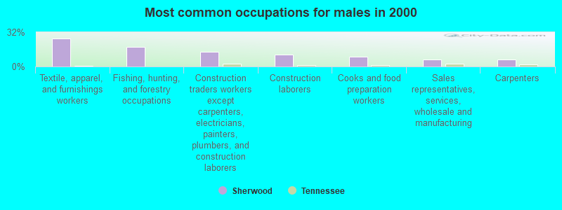
- Textile, apparel, and furnishings workers (26.4%)
- Fishing, hunting, and forestry occupations (18.2%)
- Construction traders workers except carpenters, electricians, painters, plumbers, and construction laborers (13.6%)
- Construction laborers (10.9%)
- Cooks and food preparation workers (9.1%)
- Sales representatives, services, wholesale and manufacturing (6.4%)
- Carpenters (6.4%)
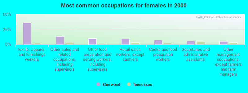
- Textile, apparel, and furnishings workers (35.9%)
- Other sales and related occupations, including supervisors (13.4%)
- Other food preparation and serving workers, including supervisors (9.9%)
- Retail sales workers, except cashiers (9.2%)
- Cooks and food preparation workers (7.0%)
- Secretaries and administrative assistants (5.6%)
- Other management occupations, except farmers and farm managers (4.9%)
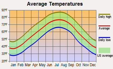
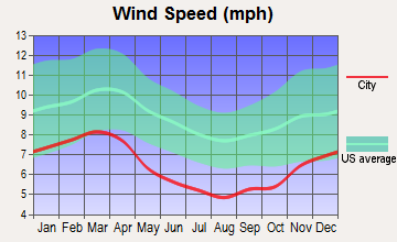
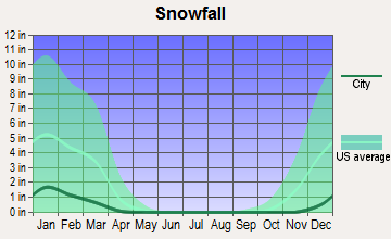
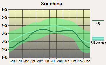
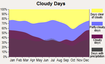
Average climate in Sherwood, Tennessee
Based on data reported by over 4,000 weather stations
(lower is better)
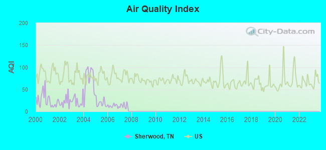
Air Quality Index (AQI) level in 2007 was 13.2. This is significantly better than average.
| City: | 13.2 |
| U.S.: | 72.6 |
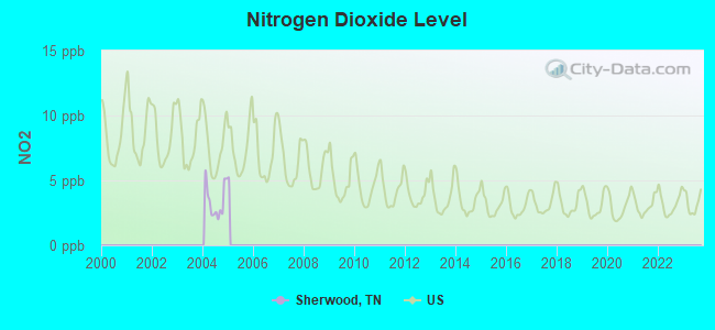
Nitrogen Dioxide (NO2) [ppb] level in 2004 was 3.44. This is significantly better than average. Closest monitor was 13.8 miles away from the city center.
| City: | 3.44 |
| U.S.: | 5.11 |
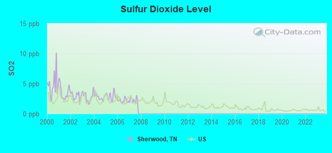
Sulfur Dioxide (SO2) [ppb] level in 2007 was 2.27. This is significantly worse than average. Closest monitor was 9.0 miles away from the city center.
| City: | 2.27 |
| U.S.: | 1.51 |
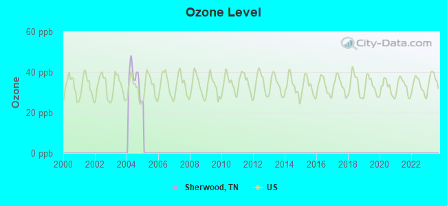
Ozone [ppb] level in 2004 was 36.3. This is about average. Closest monitor was 17.1 miles away from the city center.
| City: | 36.3 |
| U.S.: | 33.3 |
Tornado activity:
Sherwood-area historical tornado activity is slightly above Tennessee state average. It is 91% greater than the overall U.S. average.
On 4/3/1974, a category F5 (max. wind speeds 261-318 mph) tornado 30.7 miles away from the Sherwood place center killed 16 people and injured 190 people.
On 2/13/1952, a category F4 (max. wind speeds 207-260 mph) tornado 14.2 miles away from the place center killed 3 people and injured 44 people and caused between $50,000 and $500,000 in damages.
Earthquake activity:
Sherwood-area historical earthquake activity is significantly above Tennessee state average. It is 141% greater than the overall U.S. average.On 4/29/2003 at 08:59:39, a magnitude 4.9 (4.4 MB, 4.6 MW, 4.9 LG, Class: Light, Intensity: IV - V) earthquake occurred 42.6 miles away from the city center
On 4/29/2003 at 08:59:39, a magnitude 4.6 (4.6 MW, Depth: 12.3 mi) earthquake occurred 42.6 miles away from Sherwood center
On 1/18/1999 at 07:00:53, a magnitude 4.8 (4.8 MB, 4.0 LG, Depth: 0.6 mi) earthquake occurred 137.6 miles away from the city center
On 4/18/2008 at 09:36:59, a magnitude 5.4 (5.1 MB, 4.8 MS, 5.4 MW, 5.2 MW, Class: Moderate, Intensity: VI - VII) earthquake occurred 258.6 miles away from Sherwood center
On 11/30/1973 at 07:48:41, a magnitude 4.7 (4.7 MB, 4.6 ML) earthquake occurred 121.7 miles away from the city center
On 12/12/2018 at 09:14:43, a magnitude 4.4 (4.4 MW, Depth: 4.9 mi) earthquake occurred 77.2 miles away from Sherwood center
Magnitude types: regional Lg-wave magnitude (LG), body-wave magnitude (MB), local magnitude (ML), surface-wave magnitude (MS), moment magnitude (MW)
Natural disasters:
The number of natural disasters in Franklin County (11) is smaller than the US average (15).Major Disasters (Presidential) Declared: 8
Emergencies Declared: 2
Causes of natural disasters: Floods: 4, Storms: 4, Tornadoes: 4, Winter Storms: 3, Winds: 2, Flash Flood: 1, Heavy Rain: 1, Hurricane: 1, Ice Storm: 1, Snowfall: 1, Other: 1 (Note: some incidents may be assigned to more than one category).
Hospitals and medical centers near Sherwood:
- EMERALD-HODGSON HEALTH CARE CENTER (Nursing Home, about 11 miles away; SEWANEE, TN)
- RCG WINCHESTER (Dialysis Facility, about 12 miles away; WINCHESTER, TN)
- CARESOUTH HHA HOLDINGS OF WINCHESTER, LLC (Home Health Center, about 12 miles away; WINCHESTER, TN)
- GOLDEN LIVINGCENTER - MOUNTAIN VIEW (Nursing Home, about 13 miles away; WINCHESTER, TN)
- SOUTHERN TENNESSEE MEDICAL CENTER Acute Care Hospitals (about 13 miles away; WINCHESTER, TN)
- WILLOWS AT WINCHESTER CARE AND REHABILITATION CENTER (Nursing Home, about 13 miles away; WINCHESTER, TN)
- BRIDGE AT SOUTH PITTSBURG, THE (Nursing Home, about 13 miles away; SOUTH PITTSBURG, TN)
Colleges/universities with over 2000 students nearest to Sherwood:
- Motlow State Community College (about 30 miles; Tullahoma, TN; Full-time enrollment: 2,915)
- The University of Tennessee-Chattanooga (about 36 miles; Chattanooga, TN; FT enrollment: 10,158)
- Northeast Alabama Community College (about 36 miles; Rainsville, AL; FT enrollment: 2,409)
- Chattanooga State Community College (about 39 miles; Chattanooga, TN; FT enrollment: 6,827)
- Alabama A & M University (about 42 miles; Normal, AL; FT enrollment: 4,524)
- University of Alabama in Huntsville (about 47 miles; Huntsville, AL; FT enrollment: 6,006)
- Southern Adventist University (about 50 miles; Collegedale, TN; FT enrollment: 2,898)
Points of interest:
Notable locations in Sherwood: Posey Field (A), Sinking Cove (B), Crow Creek Valley Volunteer Fire Department Station 1 (C), Crow Creek Valley Volunteer Fire Department Station 2 (D). Display/hide their locations on the map
Church in Sherwood: Gounce Church (A). Display/hide its location on the map
Cemeteries: Jackson Cemetery (1), Lynch Cemetery (2), Red Hill Cemetery (3), Morris Cemetery (4), Crownover Cemetery (5), Gonce Cemetery (6), Sherwood Cemetery (7). Display/hide their locations on the map
Streams, rivers, and creeks: Lost Creek (A), Laurel Branch (B), Youngs Creek (C), Dry Creek (D), Cross Creek (E), Buck Creek (F), Holly Flat Creek (G), Vine Branch (H), Willis Branch (I). Display/hide their locations on the map
Park in Sherwood: Mister and Mrs Larry Lee Carter Natural Area (1). Display/hide its location on the map
| This place: | 2.4 people |
| Tennessee: | 2.5 people |
| This place: | 61.5% |
| Whole state: | 69.8% |
| This place: | 2.7% |
| Whole state: | 4.2% |
Likely homosexual households (counted as self-reported same-sex unmarried-partner households)
- Lesbian couples: 0.0% of all households
- Gay men: 0.5% of all households
| This place: | 12.9% |
| Whole state: | 13.5% |
| This place: | 3.4% |
| Whole state: | 5.8% |
For population 15 years and over in Sherwood:
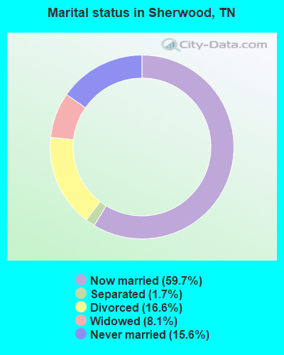
- Never married: 15.6%
- Now married: 59.7%
- Separated: 1.7%
- Widowed: 8.1%
- Divorced: 16.6%
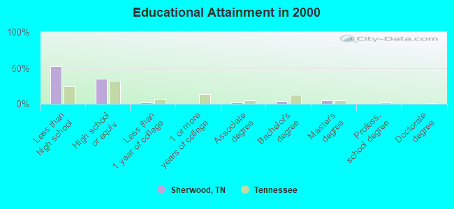
For population 25 years and over in Sherwood:
- High school or higher: 47.5%
- Bachelor's degree or higher: 9.1%
- Graduate or professional degree: 5.2%
- Unemployed: 6.7%
- Mean travel time to work (commute): 29.0 minutes
| Here: | 18.0 |
| Tennessee average: | 13.3 |


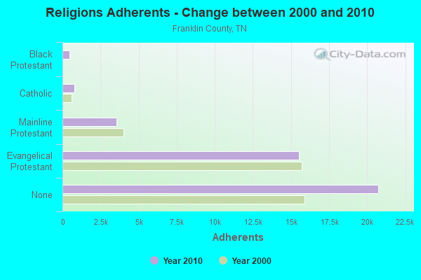
Graphs represent county-level data. Detailed 2008 Election Results
Religion statistics for Sherwood, TN (based on Franklin County data)
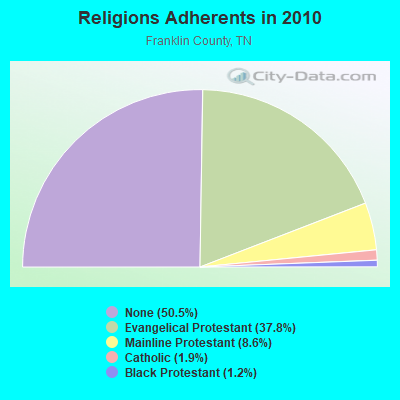
| Religion | Adherents | Congregations |
|---|---|---|
| Evangelical Protestant | 15,502 | 80 |
| Mainline Protestant | 3,525 | 20 |
| Catholic | 800 | 1 |
| Black Protestant | 480 | 4 |
| Other | 4 | 2 |
| None | 20,741 | - |
Food Environment Statistics:
| This county: | 2.68 / 10,000 pop. |
| State: | 1.99 / 10,000 pop. |
| This county: | 0.24 / 10,000 pop. |
| Tennessee: | 0.17 / 10,000 pop. |
| Franklin County: | 0.73 / 10,000 pop. |
| Tennessee: | 0.65 / 10,000 pop. |
| Franklin County: | 6.57 / 10,000 pop. |
| Tennessee: | 5.16 / 10,000 pop. |
| This county: | 5.11 / 10,000 pop. |
| Tennessee: | 6.56 / 10,000 pop. |
| Here: | 10.6% |
| Tennessee: | 11.4% |
| Franklin County: | 30.1% |
| Tennessee: | 30.2% |
| Franklin County: | 14.9% |
| Tennessee: | 13.5% |
Strongest AM radio stations in Sherwood:
- WWAM (820 AM; daytime; 50 kW; JASPER, TN; Owner: SHELTON BROADCASTING SYSTEM)
- WFLI (1070 AM; 50 kW; LOOKOUT MOUNTAIN, TN; Owner: WFLI, INC.)
- WZYX (1440 AM; 5 kW; COWAN, TN; Owner: TIMS FORD BROADCASTING COMPANY, INC.)
- WEPG (910 AM; 5 kW; SOUTH PITTSBURG, TN; Owner: STONE/COLLINS COMMUNICATIONS, INC.)
- WLOR (1550 AM; 50 kW; HUNTSVILLE, AL; Owner: BCA RADIO, LLC)
- WSM (650 AM; 50 kW; NASHVILLE, TN; Owner: GAYLORD ENTERTAINMENT COMPANY)
- WNSI (810 AM; 50 kW; JACKSONVILLE, AL; Owner: UNITED BROADCASTING NETWORK, INC.)
- WBXR (1140 AM; daytime; 15 kW; HAZEL GREEN, AL; Owner: LOW COUNTRY CORPORATION, INC.)
- WQRX (870 AM; daytime; 10 kW; VALLEY HEAD, AL; Owner: BARINOWSKI INVESTMENT COMPANY)
- WZCT (1330 AM; 5 kW; SCOTTSBORO, AL; Owner: BONNER AND CARLILE ENTERPRISES)
- WAMB (1160 AM; 50 kW; DONELSON, TN; Owner: GREAT SOUTHERN BROADCASTING COMPANY, INC.)
- WGST (640 AM; 50 kW; ATLANTA, GA; Owner: CITICASTERS LICENSES, L.P.)
- WKNG (1060 AM; daytime; 50 kW; TALLAPOOSA, GA; Owner: WKNG, INC.)
Strongest FM radio stations in Sherwood:
- WMXF-FM (97.3 FM; SOUTH PITTSBURG, TN; Owner: CAPSTAR TX LIMITED PARTNERSHIP)
- WMBW (88.9 FM; CHATTANOOGA, TN; Owner: THE MOODY BIBLE INSTITUTE OF CHICAGO)
- WUSY (100.7 FM; CLEVELAND, TN; Owner: CAPSTAR TX LIMITED PARTNERSHIP)
- WBDX (102.7 FM; TRENTON, GA; Owner: PARTNERS FOR CHRISTIAN RADIO, INC.)
- WUSX (93.3 FM; TULLAHOMA, TN; Owner: TENNNESSE VALLEY RADIO, INC)
- WMXN-FM (101.7 FM; STEVENSON, AL; Owner: KEA RADIO, INC.)
- W257AZ (99.3 FM; LOOKOUT MOUNTAIN, TN; Owner: CAPSTAR TX LIMITED PARTNERSHIP)
- WDEF-FM (92.3 FM; CHATTANOOGA, TN; Owner: JACKSON TELECASTERS, INC.)
- WAHR (99.1 FM; HUNTSVILLE, AL; Owner: BCA RADIO, LLC)
- WDOD-FM (96.5 FM; CHATTANOOGA, TN; Owner: WDOD OF CHATTANOOGA, INC.)
- WSKZ (106.5 FM; CHATTANOOGA, TN; Owner: CITADEL BROADCASTING COMPANY)
- WSGM (104.7 FM; COALMONT, TN; Owner: CUMBERLAND COMMUNICATION CORPORATION)
- W289AC (105.7 FM; HUNTSVILLE, AL; Owner: WILLIAM PAXTON ROGERS)
- WOGT (107.9 FM; EAST RIDGE, TN; Owner: CITADEL BROADCASTING COMPANY)
- WXQW (94.1 FM; MERIDIANVILLE, AL; Owner: CAPSTAR TX LIMITED PARTNERSHIP)
- W293AH (106.5 FM; NORMAL, AL; Owner: CAPSTAR TX LIMITED PARTNERSHIP)
- WWTN (99.7 FM; MANCHESTER, TN; Owner: CUMULUS LICENSING CORP.)
- WKXJ (98.1 FM; SIGNAL MOUNTAIN, TN; Owner: CAPSTAR TX LIMITED PARTNERSHIP)
- W278AC (103.5 FM; WALDEN, TN; Owner: CAPSTAR TX LIMITED PARTNERSHIP)
- WSMC-FM (90.5 FM; COLLEGEDALE, TN; Owner: SOUTHERN COLLEGE OF SEVENTH-DAY ADVT)
TV broadcast stations around Sherwood:
- WFLI-TV (Channel 53; CLEVELAND, TN; Owner: CHATTANOOGA MEDIA HOLDINGS, L.L.C.)
- WZDX (Channel 54; HUNTSVILLE, AL; Owner: HUNTSVILLE TELEVISION ACQUISITION CORP.)
- W64BJ (Channel 64; SCOTTSBORO, AL; Owner: TRINITY BROADCASTING NETWORK)
- WAAY-TV (Channel 31; HUNTSVILLE, AL; Owner: PIEDMONT TELEVISION OF HUNTSVILLE LICENSE LLC)
- WHNT-TV (Channel 19; HUNTSVILLE, AL; Owner: NEW YORK TIMES MANAGEMENT SERVICES)
Sherwood fatal accident list:
FCC Registered Antenna Towers:
5- Conchita Jones, Off Spring Street (Lat: 35.068750 Lon: -85.923389), Type: 89.9, Structure height: 47051 m, Overall height: 85.3 m, Registrant: At&t Mobility, LLC, Cm7512@att.Com, Suite 1000, 4573067 Washi-ngton, Phone: (202) 457-3067
- Kevin Hetrick, Off Spring Street (Lat: 35.068750 Lon: -85.923389), Type: 89.9, Structure height: 47051 m, Overall height: 85.3 m, Registrant: At&t Mobility, LLC, Cm7512@att.Com, Suite 1000, 4573067 Washi-ngton, Phone: (202) 457-3067
- Kevin Hetrick, Off Spring Street (Lat: 35.068750 Lon: -85.923389), Type: 89.9, Structure height: 47051 m, Overall height: 85.3 m, Registrant: At&t Services, Inc., Fccmw@att.Com, , Dalla-s, Phone: (855) 699-7073
- Dawn L Keniley, Off Spring Street (Lat: 35.068750 Lon: -85.923389), Type: 89.9, Structure height: 47051 m, Overall height: 85.3 m, Registrant: Vertical Bridge Development, LLC, Fcc-Faa@verticalbridge.Com, Suite 200, Boca -Raton, Phone: (561) 406-4105
- Dawn L Keniley, Off Spring Street (Lat: 35.068750 Lon: -85.923389), Type: 89.9, Structure height: 47051 m, Overall height: 85.3 m, Registrant: Vertical Bridge Development, LLC, Fcc-Faa@verticalbridge.Com, Suite 200, Boca -Raton, Phone: (561) 406-4105
FCC Registered Broadcast Land Mobile Towers:
3- 9810 Sherwood Rd (Lat: 35.075639 Lon: -85.923861), Type: Pole, Structure height: 19 m, Overall height: 21 m, Call Sign: WPQA205, Licensee ID: L00258361,
Assigned Frequencies: 935.887 MHz, 935.937 MHz, 935.987 MHz, 936.887 MHz, 936.937 MHz, 936.987 MHz, Grant Date: 04/12/2000, Expiration Date: 04/12/2005, Cancellation Date: 01/28/2005, Certifier: Robert Vandeberg, Registrant: Association Of American Railroads Dba Transportation Technology Center Csxt, 55500 Dot Rd, Pueblo, CO 81001, Phone: (719) 584-0578, Fax: (719) 584-7145
- 2024 Crownover Road (Lat: 34.993278 Lon: -85.904944), Call Sign: WQFK605,
Assigned Frequencies: 469.100 MHz, 469.400 MHz, 469.900 MHz, Grant Date: 08/04/2006, Expiration Date: 08/04/2016, Cancellation Date: 10/08/2016, Certifier: Nathan Steele, Registrant: Tunnel Radio Of America, 33868 Se Eastgate Circle, Corvallis, OR 97333, Phone: (541) 758-5637, Fax: (541) 758-1417, Email:
- Lat: 34.994417 Lon: -85.903333, Call Sign: WQPS862,
Assigned Frequencies: 467.262 MHz, 467.287 MHz, 467.312 MHz, 467.362 MHz, 467.412 MHz, 467.337 MHz, 467.237 MHz, 467.387 MHz, 462.362 MHz, 462.412 MHz, Grant Date: 08/07/2012, Expiration Date: 08/07/2022, Cancellation Date: 10/08/2022, Certifier: Chris Counts, Registrant: Shuttlewagon Inc, 4116 Doctor Greaves Road, Grandview, MO 64030-1138, Phone: (816) 569-4643, Fax: (816) 763-0705, Email:
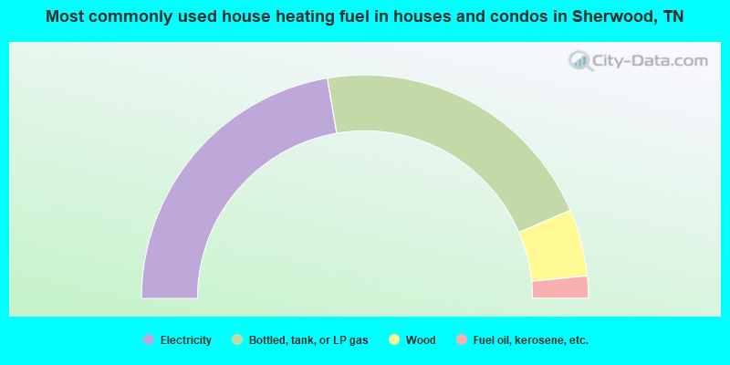
- 44.6%Electricity
- 42.5%Bottled, tank, or LP gas
- 9.7%Wood
- 3.2%Fuel oil, kerosene, etc.
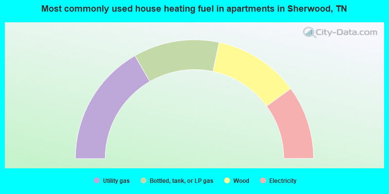
- 33.3%Utility gas
- 23.3%Bottled, tank, or LP gas
- 23.3%Wood
- 20.0%Electricity
Sherwood compared to Tennessee state average:
- Median household income below state average.
- Median house value significantly below state average.
- Unemployed percentage below state average.
- Black race population percentage significantly below state average.
- Hispanic race population percentage significantly below state average.
- Foreign-born population percentage significantly below state average.
- Renting percentage significantly below state average.
- Length of stay since moving in significantly above state average.
- Number of rooms per house significantly below state average.
- House age significantly below state average.
- Number of college students significantly below state average.
- Percentage of population with a bachelor's degree or higher significantly below state average.