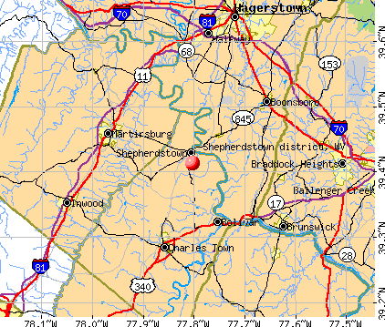
Shepherdstown district, West Virginia
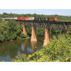
Shepherdstown district: Train crossing the Potomac River Bridge at Shepherdstown W.V.
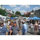
Shepherdstown district: German Street
- add
your
Submit your own pictures of this city and show them to the world
- OSM Map
- General Map
- Google Map
- MSN Map
| Males: 5,200 | |
| Females: 5,245 |
| Median resident age: | 36.8 years |
| West Virginia median age: | 38.9 years |
Zip code: 25443
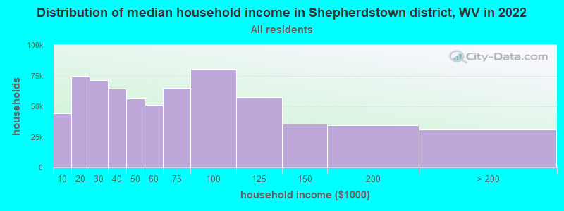
| Shepherdstown district: | $108,497 |
| WV: | $54,329 |
Estimated per capita income in 2022: $48,775 (it was $23,198 in 2000)
Shepherdstown district income, earnings, and wages data
Estimated median house or condo value in 2022: $475,805 (it was $162,900 in 2000)
| Shepherdstown district: | $475,805 |
| WV: | $155,100 |
Shepherdstown district, WV residents, houses, and apartments details
Detailed information about poverty and poor residents in Shepherdstown district, WV

Compare current foreclosures near Shepherdstown district, WV:


- 7,84690.3%White alone
- 4885.6%Black alone
- 1171.3%Hispanic
- 1061.2%Two or more races
- 911.0%Asian alone
- 280.3%American Indian alone
- 70.08%Other race alone
- 50.06%Native Hawaiian and Other
Pacific Islander alone
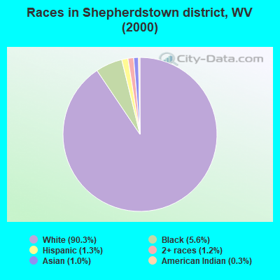
Races in Shepherdstown district detailed stats: ancestries, foreign born residents, place of birth
 Recent articles from our blog. Our writers, many of them Ph.D. graduates or candidates, create easy-to-read articles on a wide variety of topics.
Current Local Time: EST time zone
Land area: 50.1 square miles.
Population density: 208 people per square mile (very low).

| Shepherdstown district: | 0.6% ($896) |
| West Virginia: | 0.6% ($378) |
Nearest city with pop. 50,000+: Frederick, MD  (20.5 miles , pop. 52,767).
Nearest city with pop. 200,000+: Washington, DC (54.7 miles , pop. 572,059).
Nearest city with pop. 1,000,000+: Philadelphia, PA (147.1 miles , pop. 1,517,550).
Nearest cities:
), )Latitude: 39.41 N, Longitude: 77.80 W
Area code commonly used in this area: 304

| Here: | 2.7% |
| West Virginia: | 4.0% |
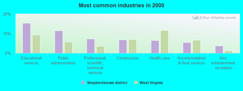
- Educational services (15.3%)
- Public administration (11.5%)
- Professional, scientific, technical services (7.3%)
- Construction (6.8%)
- Health care (6.5%)
- Accommodation & food services (5.4%)
- Arts, entertainment, recreation (3.8%)
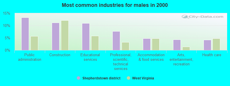
- Public administration (13.2%)
- Construction (11.2%)
- Educational services (11.0%)
- Professional, scientific, technical services (7.6%)
- Accommodation & food services (4.8%)
- Arts, entertainment, recreation (4.3%)
- Health care (4.2%)
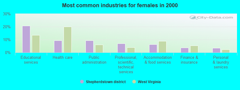
- Educational services (20.8%)
- Health care (9.4%)
- Public administration (9.4%)
- Professional, scientific, technical services (6.9%)
- Accommodation & food services (6.3%)
- Finance & insurance (3.8%)
- Personal & laundry services (3.5%)
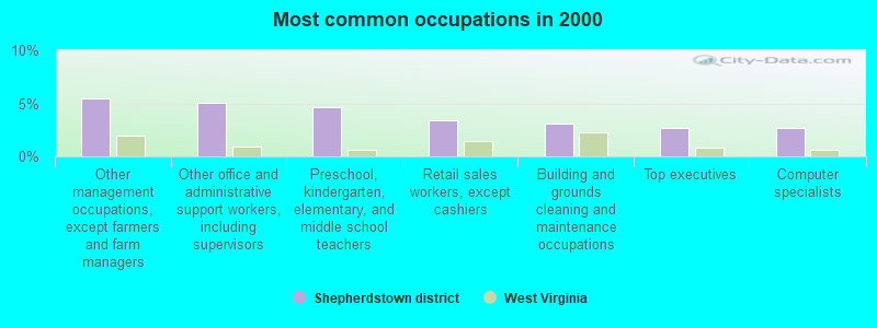
- Other management occupations, except farmers and farm managers (5.5%)
- Other office and administrative support workers, including supervisors (5.1%)
- Preschool, kindergarten, elementary, and middle school teachers (4.6%)
- Retail sales workers, except cashiers (3.4%)
- Building and grounds cleaning and maintenance occupations (3.1%)
- Top executives (2.7%)
- Computer specialists (2.7%)
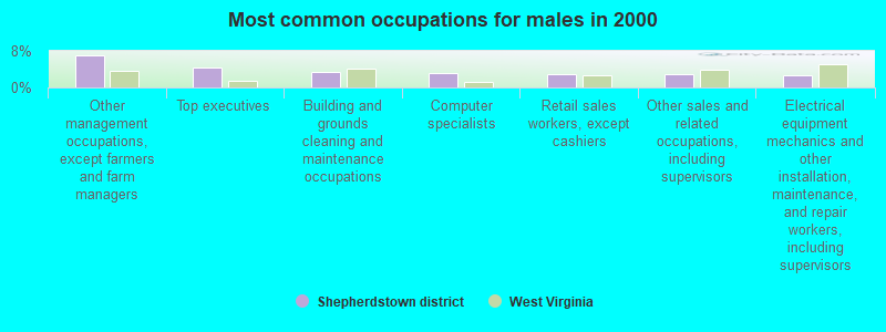
- Other management occupations, except farmers and farm managers (7.1%)
- Top executives (4.3%)
- Building and grounds cleaning and maintenance occupations (3.5%)
- Computer specialists (3.2%)
- Retail sales workers, except cashiers (3.0%)
- Other sales and related occupations, including supervisors (2.9%)
- Electrical equipment mechanics and other installation, maintenance, and repair workers, including supervisors (2.8%)
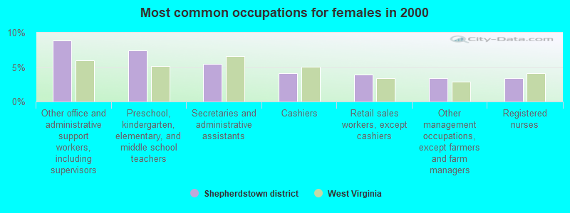
- Other office and administrative support workers, including supervisors (8.9%)
- Preschool, kindergarten, elementary, and middle school teachers (7.4%)
- Secretaries and administrative assistants (5.5%)
- Cashiers (4.1%)
- Retail sales workers, except cashiers (3.9%)
- Other management occupations, except farmers and farm managers (3.5%)
- Registered nurses (3.4%)
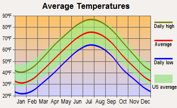
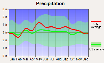
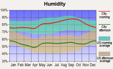
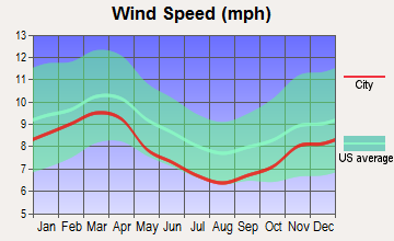
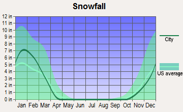
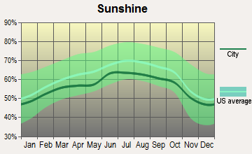
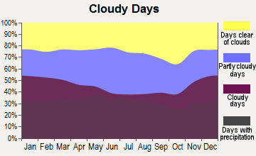
Average climate in Shepherdstown district, West Virginia
Based on data reported by over 4,000 weather stations
(lower is better)
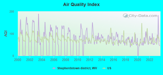
Air Quality Index (AQI) level in 2023 was 80.4. This is about average.
| City: | 80.4 |
| U.S.: | 72.6 |
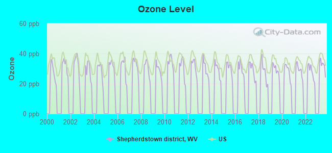
Ozone [ppb] level in 2023 was 32.2. This is about average. Closest monitor was 8.9 miles away from the city center.
| City: | 32.2 |
| U.S.: | 33.3 |
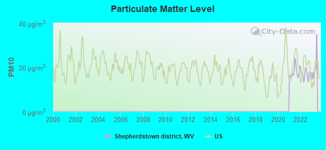
Particulate Matter (PM10) [µg/m3] level in 2022 was 16.8. This is about average. Closest monitor was 8.9 miles away from the city center.
| City: | 16.8 |
| U.S.: | 19.2 |
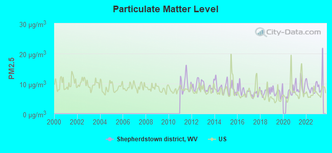
Particulate Matter (PM2.5) [µg/m3] level in 2022 was 8.64. This is about average. Closest monitor was 8.9 miles away from the city center.
| City: | 8.64 |
| U.S.: | 8.11 |
Tornado activity:
Shepherdstown district-area historical tornado activity is significantly above West Virginia state average. It is 7% smaller than the overall U.S. average.
On 9/24/2001, a category F4 (max. wind speeds 207-260 mph) tornado 48.0 miles away from the Shepherdstown district city center injured 2 people and caused $2 million in damages.
On 5/22/1983, a category F3 (max. wind speeds 158-206 mph) tornado 35.5 miles away from the city center caused between $5000 and $50,000 in damages.
Earthquake activity:
Shepherdstown district-area historical earthquake activity is significantly above West Virginia state average. It is 54% smaller than the overall U.S. average.On 8/23/2011 at 17:51:04, a magnitude 5.8 (5.8 MW, Depth: 3.7 mi, Class: Moderate, Intensity: VI - VII) earthquake occurred 104.3 miles away from Shepherdstown district center
On 9/25/1998 at 19:52:52, a magnitude 5.2 (4.8 MB, 4.3 MS, 5.2 LG, 4.5 MW, Depth: 3.1 mi) earthquake occurred 198.2 miles away from the city center
On 1/16/1994 at 01:49:16, a magnitude 4.6 (4.6 MB, 4.6 LG, Depth: 3.1 mi, Class: Light, Intensity: IV - V) earthquake occurred 113.2 miles away from Shepherdstown district center
On 8/25/2011 at 05:07:52, a magnitude 4.5 (4.5 ML, Depth: 4.2 mi) earthquake occurred 101.8 miles away from the city center
On 12/9/2003 at 20:59:18, a magnitude 4.5 (4.5 ML, Depth: 6.2 mi) earthquake occurred 114.5 miles away from the city center
On 12/9/2003 at 20:59:14, a magnitude 4.5 (4.5 MB, 4.5 LG) earthquake occurred 126.4 miles away from the city center
Magnitude types: regional Lg-wave magnitude (LG), body-wave magnitude (MB), local magnitude (ML), surface-wave magnitude (MS), moment magnitude (MW)
Natural disasters:
The number of natural disasters in Jefferson County (16) is near the US average (15).Major Disasters (Presidential) Declared: 11
Emergencies Declared: 4
Causes of natural disasters: Storms: 5, Floods: 4, Hurricanes: 4, Winter Storms: 3, Landslides: 2, Mudslides: 2, Snowstorms: 2, Blizzard: 1, Snowfall: 1, Tornado: 1, Tropical Storm: 1, Wind: 1, Other: 1 (Note: some incidents may be assigned to more than one category).
Hospitals and medical centers near Shepherdstown district:
- CANTERBURY CENTER (Nursing Home, about 2 miles away; SHEPHERDSTOWN, WV)
- JEFFERSON MEDICAL CENTER Critical Access Hospitals (about 9 miles away; RANSON, WV)
- JEFFERSON MEM. HOSPITAL, D/P (Nursing Home, about 9 miles away; RANSON, WV)
- MARTINSBURG VA MEDICAL CENTER (Hospital, Acute Care - Veterans Administration, about 9 miles away; MARTINSBURG, WV)
- GABOYA PLACE GROUP HOME (Hospital, about 9 miles away; MARTINSBURG, WV)
- WVUH-EAST HOME HEALTH CARE (Home Health Center, about 10 miles away; CHARLES TOWN, WV)
- HEARTLAND OF MARTINSBURG (Nursing Home, about 10 miles away; MARTINSBURG, WV)
Amtrak stations near Shepherdstown district:
- 8 miles: HARPERS FERRY (POTOMAC ST.) . Services: enclosed waiting area, public restrooms, public payphones, free short-term parking, free long-term parking, public transit connection.
- 10 miles: MARTINSBURG (229 E. MARTIN ST.) . Services: fully wheelchair accessible, enclosed waiting area, public restrooms, public payphones, paid short-term parking, taxi stand, public transit connection.
- 12 miles: HAGERSTOWN (GREYHOUND STA., 10527 SHARPSTOWN PK.) - Bus Station . Services: enclosed waiting area, public restrooms, public payphones, snack bar.
Colleges/universities with over 2000 students nearest to Shepherdstown district:
- Shepherd University (about 2 miles; Shepherdstown, WV; Full-time enrollment: 3,745)
- American Public University System (about 10 miles; Charles Town, WV; FT enrollment: 43,829)
- Hagerstown Community College (about 17 miles; Hagerstown, MD; FT enrollment: 3,220)
- Frederick Community College (about 21 miles; Frederick, MD; FT enrollment: 3,798)
- Shenandoah University (about 26 miles; Winchester, VA; FT enrollment: 3,010)
- Mount St Mary's University (about 31 miles; Emmitsburg, MD; FT enrollment: 2,313)
- Lord Fairfax Community College (about 37 miles; Middletown, VA; FT enrollment: 4,144)
Points of interest:
Notable locations in Shepherdstown district: Shepherds Grist Mill (A), Cress Creek Country Club Golf Course (B), U S Fish and Wildlife Service National Conservation Training Center (C), Bakerton Fire Department (D), Shepherdstown Volunteer Fire Department Company 3 (E). Display/hide their locations on the map
Churches in Shepherdstown district include: Keller Church (A), Uvilla United Methodist Church (B), Saint Peters Lutheran Church (C), Saint Johns Baptist Church (D), New Street United Methodist Church (E), Christ Reformed Church (F), Berean Church (G), Bethesda United Methodist Church (H), Saint James Church (I). Display/hide their locations on the map
Cemeteries: Elmwood Cemetery (1), Reformed Graveyard (2), Buckles-Reverend Black Cemetery (3), Elk Branch Cemetery (4), Saint James Cemetery (5), Shepherds Graveyard (6), Uvilla Cemetery (7). Display/hide their locations on the map
Streams, rivers, and creeks: Town Run (A), Rockymarsh Run (B), Elks Run (C), Elk Branch (D). Display/hide their locations on the map
Parks in Shepherdstown district include: Shepherdstown Historic District (1), Rumsey Monument (2). Display/hide their locations on the map
| This city: | 2.5 people |
| West Virginia: | 2.4 people |
| This city: | 65.5% |
| Whole state: | 65.8% |
| This city: | 6.3% |
| Whole state: | 6.6% |
Likely homosexual households (counted as self-reported same-sex unmarried-partner households)
- Lesbian couples: 0.5% of all households
- Gay men: 0.7% of all households
| This city: | 9.3% |
| Whole state: | 17.9% |
| This city: | 4.3% |
| Whole state: | 7.6% |
60 people in nursing facilities/skilled-nursing facilities in 2010
909 people in college dormitories (includes college quarters off campus) in 2000
61 people in nursing homes in 2000
For population 15 years and over in Shepherdstown district:
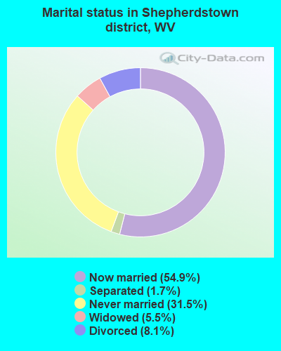
- Never married: 31.5%
- Now married: 54.9%
- Separated: 1.7%
- Widowed: 5.5%
- Divorced: 8.1%
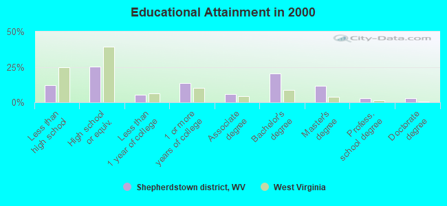
For population 25 years and over in Shepherdstown district:
- High school or higher: 88.0%
- Bachelor's degree or higher: 37.9%
- Graduate or professional degree: 17.5%
- Unemployed: 4.7%
- Mean travel time to work (commute): 31.0 minutes
| Here: | 12.6 |
| West Virginia average: | 12.7 |
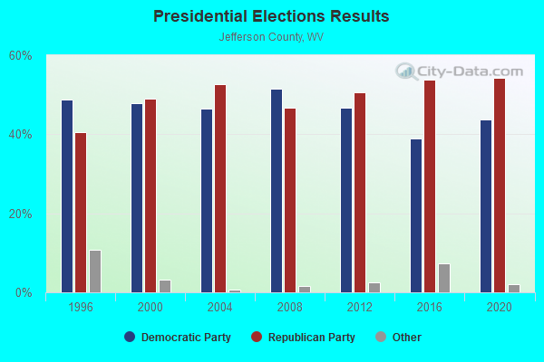
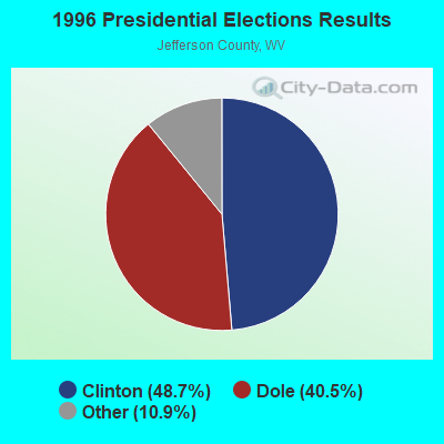
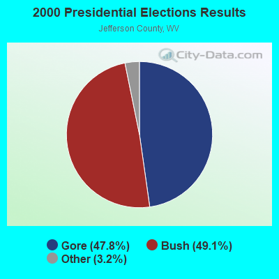
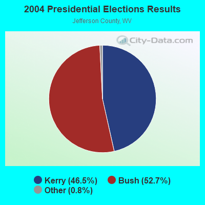
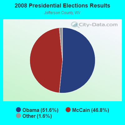
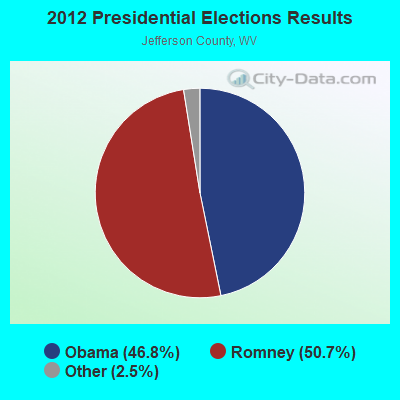
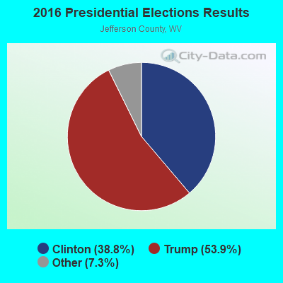
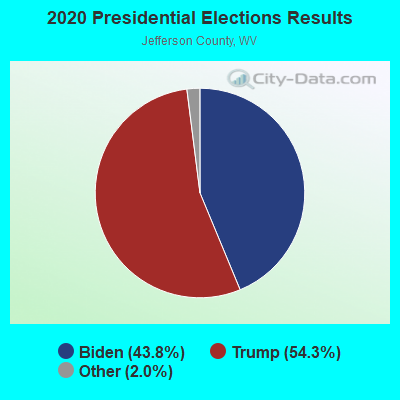
Graphs represent county-level data. Detailed 2008 Election Results
Religion statistics for Shepherdstown district, WV (based on Jefferson County data)
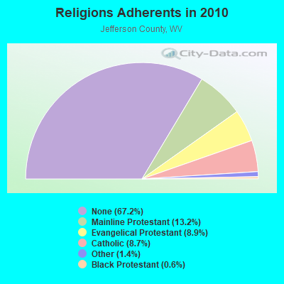
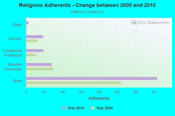
| Religion | Adherents | Congregations |
|---|---|---|
| Mainline Protestant | 7,083 | 37 |
| Evangelical Protestant | 4,756 | 27 |
| Catholic | 4,679 | 2 |
| Other | 729 | 5 |
| Black Protestant | 307 | 2 |
| None | 35,944 | - |
Food Environment Statistics:
| This county: | 1.58 / 10,000 pop. |
| State: | 2.41 / 10,000 pop. |
| Jefferson County: | 0.20 / 10,000 pop. |
| West Virginia: | 0.28 / 10,000 pop. |
| This county: | 0.98 / 10,000 pop. |
| State: | 1.09 / 10,000 pop. |
| Jefferson County: | 3.15 / 10,000 pop. |
| West Virginia: | 5.38 / 10,000 pop. |
| Jefferson County: | 7.68 / 10,000 pop. |
| West Virginia: | 6.22 / 10,000 pop. |
| Jefferson County: | 9.3% |
| State: | 12.2% |
| This county: | 30.0% |
| State: | 31.1% |
| Jefferson County: | 17.0% |
| State: | 13.1% |
Strongest AM radio stations in Shepherdstown district:
- WTRI (1520 AM; daytime; 17 kW; BRUNSWICK, MD; Owner: JMK COMMUNICATIONS, INC.)
- WMET (1150 AM; 50 kW; GAITHERSBURG, MD; Owner: BELTWAY ACQUISITION CORPORATION)
- WMRE (1550 AM; 5 kW; CHARLESTOWN, WV; Owner: CLEVELAND RADIO LICENSES, LLC)
- WCBM (680 AM; 50 kW; BALTIMORE, MD; Owner: WCBM MARYLAND, INC.)
- WTEM (980 AM; 50 kW; WASHINGTON, DC; Owner: AMFM RADIO LICENSES, L.L.C.)
- WKCW (1420 AM; 50 kW; WARRENTON, VA; Owner: WAY BROADCASTING, INC.)
- WXTR (820 AM; 4 kW; FREDERICK, MD; Owner: BONNEVILLE HOLDING COMPANY)
- WFMD (930 AM; 5 kW; FREDERICK, MD; Owner: CAPSTAR TX LIMITED PARTNERSHIP)
- WBAL (1090 AM; 50 kW; BALTIMORE, MD; Owner: HEARST RADIO, INC.)
- WTOP (1500 AM; 50 kW; WASHINGTON, DC; Owner: BONNEVILLE HOLDING COMPANY)
- WGOP (700 AM; daytime; 25 kW; WALKERSVILLE, MD; Owner: BIRACH BROADCASTING CORPORATION)
- WRNR (740 AM; 0 kW; MARTINSBURG, WV; Owner: SHENANDOAH COMMUNICATIONS, INC.)
- WPGC (1580 AM; 50 kW; MORNINGSIDE, MD; Owner: INFINITY WPGC(AM), INC.)
Strongest FM radio stations in Shepherdstown district:
- WARX (106.9 FM; HAGERSTOWN, MD; Owner: MANNING BROADCASTING INC.)
- WLTF (97.5 FM; MARTINSBURG, WV; Owner: PRETTYMAN BROADCASTING COMPANY)
- WFRE (99.9 FM; FREDERICK, MD; Owner: CAPSTAR TX LIMITED PARTNERSHIP)
- W219BX (91.7 FM; FREDERICK, MD; Owner: CEDAR RIDGE CHILDREN'S HOME & SCHOOL, INC)
- WSHC (89.7 FM; SHEPHERDSTOWN, WV; Owner: SHEPHERD COLLEGE BOARD OF GOVERNORS)
- WWVZ (103.9 FM; BRADDOCK HEIGHTS, MD; Owner: BONNEVILLE HOLDING COMPANY)
- WAYZ-FM (104.7 FM; HAGERSTOWN, MD; Owner: HJV LIMITED PARTNERSHIP)
- WETH (89.1 FM; HAGERSTOWN, MD; Owner: GREATER WASHINGTON EDUCATIONAL TELECOMMUNICATIONS ASSN.)
- W228BA (93.5 FM; LEESBURG, VA; Owner: CSN INTERNATIONAL)
- WCRH (90.5 FM; WILLIAMSPORT, MD; Owner: CEDAR RIDGE CHILDREN'S HOME & SCHOOL, INC)
- WAFY (103.1 FM; MIDDLETOWN, MD; Owner: FREDERICK BROADCASTING LLC)
- WXVA-FM (98.3 FM; CHARLES TOWN, WV; Owner: CLEVELAND RADIO LICENSES, LLC)
- WINC-FM (92.5 FM; WINCHESTER, VA; Owner: MID ATLANTIC NETWORK, INC.)
- WEEO-FM (103.7 FM; MCCONNELLSBURG, PA; Owner: ALLEGHENY MOUNTAIN NETWORK)
- WTRM (91.3 FM; WINCHESTER, VA; Owner: TIMBER RIDGE MINISTRIES, INC.)
- WKMZ (95.9 FM; WILLIAMSPORT, MD; Owner: PRETTYMAN BROADCASTING COMPANY)
- W219BE (91.7 FM; WAYNESBORO, PA; Owner: MARANATHA BIBLE INSTITUTE, NDBA)
- W243AF (96.5 FM; FLINT HILL, VA; Owner: CSN INTERNATIONAL)
- WUSQ-FM (102.5 FM; WINCHESTER, VA; Owner: CAPSTAR TX LIMITED PARTNERSHIP)
- WSRT (92.1 FM; MERCERSBURG, PA; Owner: M. BELMONT VERSTANDIG, INC.)
TV broadcast stations around Shepherdstown district:
- W42CK (Channel 42; HAGERSTOWN, MD; Owner: THREE ANGELS BROADCASTING)
- WHAG-TV (Channel 25; HAGERSTOWN, MD; Owner: QUORUM OF MARYLAND LICENSE, LLC)
- WWPB (Channel 31; HAGERSTOWN, MD; Owner: MARYLAND PUBLIC BROADCASTING COMMISSION)
- WWPX (Channel 60; MARTINSBURG, WV; Owner: PAXSON WASHINGTON-60 LICENSE, INC.)
- WFPT (Channel 62; FREDERICK, MD; Owner: MARYLAND PUBLIC BROADCASTING COMMISSION)
- W52AS (Channel 52; FREDERICK, MD; Owner: THREE ANGELS BROADCASTING NETWORK)
- W44AA (Channel 44; MARTINSBURG, WV; Owner: WEST VIRGINIA EDUCATIONAL BROADCASTING AUTHORITY)
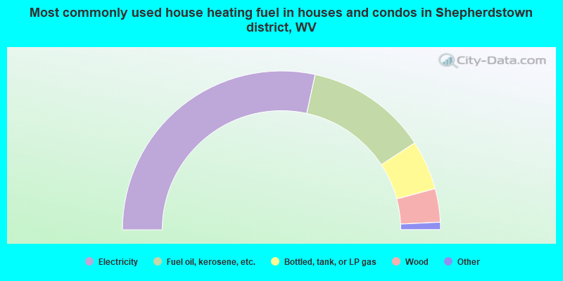
- 56.8%Electricity
- 24.8%Fuel oil, kerosene, etc.
- 10.1%Bottled, tank, or LP gas
- 6.8%Wood
- 1.0%Utility gas
- 0.3%Solar energy
- 0.3%No fuel used
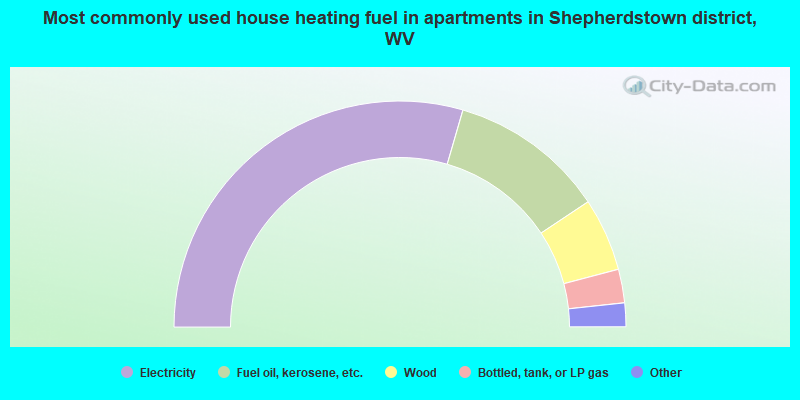
- 59.0%Electricity
- 22.3%Fuel oil, kerosene, etc.
- 10.5%Wood
- 4.8%Bottled, tank, or LP gas
- 1.7%Other fuel
- 1.4%Utility gas
- 0.3%No fuel used
Shepherdstown district compared to West Virginia state average:
- Median household income above state average.
- Median house value significantly above state average.
- Unemployed percentage significantly below state average.
- Black race population percentage above state average.
- Median age below state average.
- Foreign-born population percentage significantly below state average.
- Length of stay since moving in significantly above state average.
- Number of rooms per house significantly below state average.
- House age significantly below state average.
- Number of college students above state average.
- Percentage of population with a bachelor's degree or higher above state average.
Shepherdstown district on our top lists:
- #10 on the list of "Top 101 cities with largest percentage of females in industries: rail transportation (population 5,000+)"
- #18 on the list of "Top 101 cities with largest percentage of males in occupations: other teachers and instructors, education, training, and library occupations (population 5,000+)"
- #24 on the list of "Top 101 cities with largest percentage of females in occupations: transportation, tourism, and lodging attendants (population 5,000+)"
- #33 on the list of "Top 101 cities with largest percentage of females in occupations: operations specialties managers except financial managers (population 5,000+)"
- #34 on the list of "Top 101 cities with largest percentage of females in industries: water transportation (population 5,000+)"
- #37 on the list of "Top 101 cities with largest percentage of females in industries: office supplies and stationery stores (population 5,000+)"
- #39 on the list of "Top 101 cities with largest percentage of males in occupations: librarians, curators, and archivists (population 5,000+)"
- #43 on the list of "Top 101 cities with largest percentage of males in occupations: supervisors and other personal care and service workers except personal appearance, transportation, and child care workers (population 5,000+)"
- #47 on the list of "Top 101 cities with largest percentage of males in industries: clothing and accessories, including shoe, stores (population 5,000+)"
- #56 on the list of "Top 101 cities with largest percentage of males in occupations: other health diagnosing and treating practitioners and technical occupations (population 5,000+)"
- #57 on the list of "Top 101 cities with largest percentage of males in industries: farm supplies merchant wholesalers (population 5,000+)"
- #67 on the list of "Top 101 cities with largest percentage of females in industries: building material and garden equipment and supplies dealers (population 5,000+)"
- #87 on the list of "Top 101 cities with largest percentage of females in industries: music stores (population 5,000+)"
- #96 on the list of "Top 101 cities with largest percentage of females in industries: furniture and home furnishing merchant wholesalers (population 5,000+)"
- #98 on the list of "Top 101 cities with largest percentage of males in industries: air transportation (population 5,000+)"