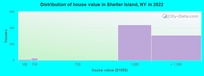
Estimated median house or condo value in 2022: over $1,000,000 (it was $260,700 in 2000)
Shelter Island:
over $1,000,000
NY:
$400,400
Mean prices in 2022:all housing units: $991,251; detached houses: $998,251March 2022 cost of living index in Shelter Island: 126.2 (high, U.S. average is 100)
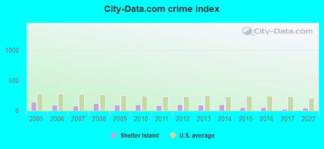
The City-Data.com crime index weighs serious crimes and violent crimes more heavily. Higher means more crime, U.S. average is 246.1. It adjusts for the number of visitors and daily workers commuting into cities.
Latest news from Shelter Island, NY collected exclusively by city-data.com from local newspapers, TV, and radio stations
Ancestries: European (23.0%), Italian (15.1%), Polish (6.3%), Czech (3.7%), German (3.3%), Northern European (3.1%).
Current Local Time: EST time zone
Elevation: 50 feet
Land area: 6.54 square miles.
Population density: 204 people per square mile (very low).
311 residents are foreign born (6.0% Latin America, 4.3% Asia, 1.9% Europe).
This place:
12.1%
New York:
22.6%
Median real estate property taxes paid for housing units with mortgages in 2022: $3,691 (0.4%) Median real estate property taxes paid for housing units with no mortgage in 2022: $5,971 (0.5%)
Nearest city with pop. 50,000+: New Haven, CT (35.4 miles , pop. 123,626).
Nearest city with pop. 200,000+: North Hempstead, NY (72.7 miles , pop. 222,611).
Nearest city with pop. 1,000,000+: Queens, NY (81.7 miles , pop. 2,229,379).
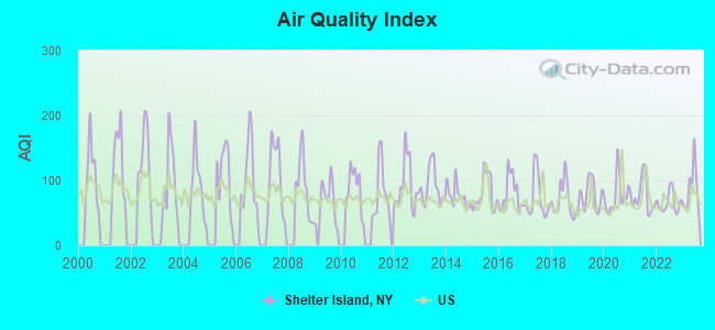
Air Quality Index (AQI) level in 2023 was 87.0. This is about average.
City:
87.0
U.S.:
72.6
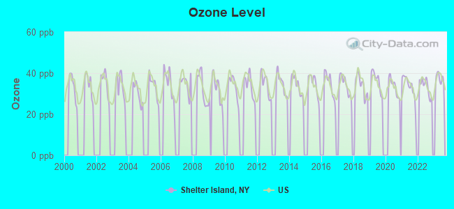
Ozone [ppb] level in 2023 was 37.0. This is about average.Closest monitor was 18.0 miles away from the city center.
City:
37.0
U.S.:
33.3
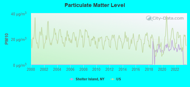
Particulate Matter (PM10) [µg/m3] level in 2022 was 12.6. This is significantly better than average.Closest monitor was 20.4 miles away from the city center.
City:
12.6
U.S.:
19.2
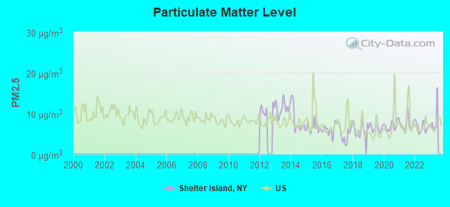
Particulate Matter (PM2.5) [µg/m3] level in 2022 was 6.58. This is better than average.Closest monitor was 24.0 miles away from the city center.
City:
6.58
U.S.:
8.11
Tornado activity:
Shelter Island-area historical tornado activity is near New York state average. It is 64% smaller than the overall U.S. average.
On 7/10/1989, a category F4 (max. wind speeds 207-260 mph) tornado 35.6 miles away from the Shelter Island place center injured 40 peopleand causedbetween $50,000,000 and $500,000,000 in damages.
On 8/21/1951, a category F3 (max. wind speeds 158-206 mph) tornado 36.9 miles away from the place center injured 8 peopleand causedbetween $50,000 and $500,000 in damages.
Earthquake activity:
Shelter Island-area historical earthquake activity is significantly above New York state average. It is 73% smaller than the overall U.S. average.
On 10/7/1983 at 10:18:46, a magnitude 5.3 (5.1 MB, 5.3 LG, 5.1 ML, Class: Moderate, Intensity: VI - VII) earthquake occurred 224.8 miles away from Shelter Island center On 4/20/2002 at 10:50:47, a magnitude 5.3 (5.3 ML, Depth: 3.0 mi) earthquake occurred 248.5 miles away from Shelter Island center On 4/20/2002 at 10:50:47, a magnitude 5.2 (5.2 MB, 4.2 MS, 5.2 MW, 5.0 MW) earthquake occurred 247.2 miles away from Shelter Island center On 8/22/1992 at 12:20:32, a magnitude 4.8 (4.8 MB, 3.8 MS, 4.7 LG, Depth: 6.2 mi, Class: Light, Intensity: IV - V) earthquake occurred 172.1 miles away from Shelter Island center On 8/23/2011 at 17:51:04, a magnitude 5.8 (5.8 MW, Depth: 3.7 mi) earthquake occurred 370.2 miles away from Shelter Island center On 1/19/1982 at 00:14:42, a magnitude 4.7 (4.5 MB, 4.7 MD, 4.5 LG) earthquake occurred 172.7 miles away from Shelter Island center Magnitude types: regional Lg-wave magnitude (LG), body-wave magnitude (MB), duration magnitude (MD), local magnitude (ML), surface-wave magnitude (MS), moment magnitude (MW)
Natural disasters:
The number of natural disasters in Suffolk County (28) is a lot greater than the US average (15). Major Disasters (Presidential) Declared: 19 Emergencies Declared: 7
Causes of natural disasters: Hurricanes: 9, Floods: 7, Storms: 7, Snowstorms: 4, Winter Storms: 3, Blizzards: 2, Heavy Rain: 1, Power Outage: 1, Tropical Depression: 1, Tropical Storm: 1, Water Shortage: 1, Other: 3 (Note: some incidents may be assigned to more than one category).
Hospitals and medical centers near Shelter Island:
EASTERN LONG ISLAND HOSPITAL Acute Care Hospitals (about 4 miles away; GREENPORT, NY)
CATHOLIC GUARDIAN SOCIETY OF NEW YORK (Hospital, about 8 miles away; EAST HAMPTON, NY)
AID TO THE DEVELOPMENTALLY DISABLED, INC (Hospital, about 8 miles away; CUTCHOGUE, NY)
THE HAMPTONS CENTER FOR REHABILITATION AND NURSING (Nursing Home, about 13 miles away; SOUTH HAMPTON, NY)
INDEPENDENT GROUP HOME LIVING PROGRAM, INC (Hospital, about 13 miles away; SOUTH HAMPTON, NY)
SOUTHAMPTON CARE CENTER (Nursing Home, about 13 miles away; SOUTHAMPTON, NY)
SOUTHAMPTON HOSPITAL Acute Care Hospitals (about 13 miles away; SOUTHAMPTON, NY)
17 miles: OLD SAYBROOK (455 BOSTON POST RD.) . Services: ticket office, partially wheelchair accessible, enclosed waiting area, public restrooms, public payphones, free short-term parking, free long-term parking, call for car rental service, call for taxi service, public transit connection.
Colleges/universities with over 2000 students nearest to Shelter Island:
Connecticut College (about 25 miles; New London, CT; Full-time enrollment: 2,068)
Three Rivers Community College (about 34 miles; Norwich, CT; FT enrollment: 2,897)
Gateway Community College (about 36 miles; New Haven, CT; FT enrollment: 4,672)
Yale University (about 36 miles; New Haven, CT; FT enrollment: 13,121)
University of New Haven (about 37 miles; West Haven, CT; FT enrollment: 6,205)
Southern Connecticut State University (about 38 miles; New Haven, CT; FT enrollment: 8,708)
Wesleyan University (about 39 miles; Middletown, CT; FT enrollment: 3,517)
SHELTER ISLAND PUBLIC LIBRARY SOCIETY (Operating income: $590,106; Location: 37 NORTH FERRY ROAD; 27,877 books; 4,881 e-books; 5,135 audio materials; 2,773 video materials; 42 local licensed databases; 14 state licensed databases; 65 print serial subscriptions; 10,470 electronic serial subscriptions)
User-submitted facts and corrections:
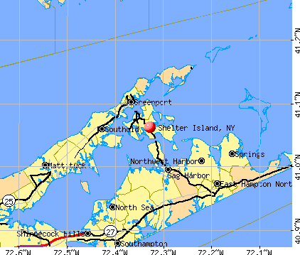
Gibson Beach which is marked on the map is within The Nature Conservancy's Mashomack Preserve and is not accessible or open to the public. Crescent Beach is a town beach with available parking and would be better to show.
Churches in Shelter Island include: Passionist Monastery (A), Saint Marys Episcopal Church (B), Shelter Island Presbyterian Church (C). Display/hide their locations on the map
Cemeteries: Nichols Cemetery (1), Shelter Island Cemetery (2), Shelter Island Presbyterian Church Burial Ground (3), Saint Mary's Episcopal Cemetery (4). Display/hide their locations on the map
MCL, Acute (TCR) - Between OCT-2006 and DEC-2006, Contaminant: Coliform. Follow-up actions: St Public Notif requested (OCT-16-2006), St Formal NOV issued (OCT-16-2006), St Compliance achieved (MAR-14-2007)
MCL, Monthly (TCR) - Between JUL-2006 and SEP-2006, Contaminant: Coliform
ISLAND BOATYARD & MARINA (Population served: 100, Groundwater):
Past health violations:
MCL, Average - In JUN-2014, Contaminant: Chloride
PRIDWIN HOTEL (Population served: 100, Groundwater):
Past monitoring violations:
One minor monitoring violation
JIM O'LINK PROPERTIES (WASTYSSIES) (Population served: 50, Groundwater):
Past health violations:
MCL, Average - Between JUL-2013 and AUG-2013, Contaminant: Manganese. Follow-up actions: St Public Notif requested (JUL-10-2013), St Formal NOV issued (JUL-10-2013), St Compliance achieved (AUG-28-2013)
MCL, Monthly (TCR) - In JUN-2014, Contaminant: Coliform
MCL, Monthly (TCR) - In APR-2012, Contaminant: Coliform. Follow-up actions: St Public Notif requested (APR-30-2012), St Formal NOV issued (APR-30-2012), St Compliance achieved (OCT-24-2012)
Drinking water stations with addresses in Shelter Island that have no violations reported:
PAT & STEVES FAMILY RESTAURANT (Population served: 75,Primary Water Source Type: Groundwater)
Likely homosexual households (counted as self-reported same-sex unmarried-partner households)
Lesbian couples: 0.7% of all households
Gay men: 1.0% of all households
Banks with branches in Shelter Island (2011 data):
JPMorgan Chase Bank, National Association: Shelter Island Branch at State Road, branch established on 1953/06/01. Info updated 2011/11/10: Bank assets: $1,811,678.0 mil, Deposits: $1,190,738.0 mil, headquarters in Columbus, OH, positive income, International Specialization, 5577 total offices, Holding Company: Jpmorgan Chase & Co.
For population 15 years and over in Shelter Island:
Never married: 29.2%
Now married: 61.6%
Separated: 0.0%
Widowed: 0.4%
Divorced: 8.8%
For population 25 years and over in Shelter Island:
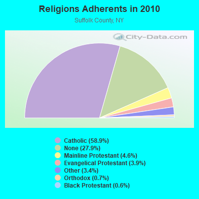
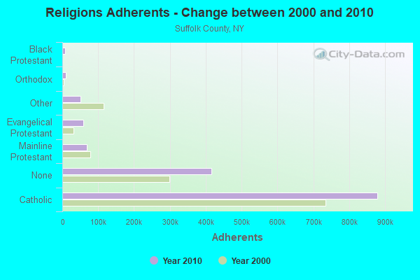
Religion statistics for Shelter Island, NY (based on Suffolk County data)
Religion
Adherents
Congregations
Catholic
879,457
75
Mainline Protestant
69,205
182
Evangelical Protestant
58,909
264
Other
50,771
124
Orthodox
10,190
10
Black Protestant
8,298
49
None
416,520
-
Source: Clifford Grammich, Kirk Hadaway, Richard Houseal, Dale E.Jones, Alexei Krindatch, Richie Stanley and Richard H.Taylor. 2012. 2010 U.S.Religion Census: Religious Congregations & Membership Study. Association of Statisticians of American Religious Bodies. Jones, Dale E., et al. 2002. Congregations and Membership in the United States 2000. Nashville, TN: Glenmary Research Center. Graphs represent county-level data
Aircraft: CESSNA R182 (Category: Land, Seats: 4, Weight: Up to 12,499 Pounds, Speed: 111 mph), Engine: LYCOMING 0-540 SERIES (250 HP) (Reciprocating) N-Number: 2656C, N2656C, N-2656C, Serial Number: R18200196, Year manufactured: 1978, Airworthiness Date: 03/02/1978, Certificate Issue Date: 03/25/2014 Registrant (Individual): Richard W Baron, Po Box 538, Shelter Island, NY 11964
Aircraft: CESSNA 150G (Category: Land, Seats: 2, Weight: Up to 12,499 Pounds, Speed: 90 mph), Engine: CONT MOTOR 0-200 SERIES (100 HP) (4 Cycle) N-Number: 3959J, N3959J, N-3959J, Serial Number: 15065259, Year manufactured: 1966, Airworthiness Date: 11/01/1966, Certificate Issue Date: 02/02/2018 Registrant (Partnership): Aire Bergin, Po Box 520, Shelter Island, NY 11964
Aircraft: PIPER PA-28-161 (Category: Land, Seats: 4, Weight: Up to 12,499 Pounds, Speed: 108 mph), Engine: LYCOMING 0-320 SERIES (180 HP) (Reciprocating) N-Number: 44VV, N44VV, N-44VV, Serial Number: 28-8116009, Year manufactured: 1980, Airworthiness Date: 08/04/1980, Certificate Issue Date: 04/26/2012 Registrant (Corporation): Hampton Warrior Ii Inc, C/O James Pugh / Po Box 520, Shelter Island, NY 11964
Aircraft: CESSNA 172 (Category: Land, Seats: 4, Weight: Up to 12,499 Pounds, Speed: 105 mph), Engine: CONT MOTOR 0-300 SER (145 HP) (Reciprocating) N-Number: 8692B, N8692B, N-8692B, Serial Number: 36392, Year manufactured: 1957, Airworthiness Date: 11/15/1957, Certificate Issue Date: 06/10/2020 Registrant (Co-Owned): Walter J Jr Cogan, Po Box 788, Shelter Island, NY 11964, Other Owners: Phillip J Lechmanski
Aircraft: ALLENS FLY BABY 1A (Category: Land, Weight: Up to 12,499 Pounds, Speed: 112 mph), Engine: CONT MOTOR A&C65 SERIES (65 HP) (Reciprocating) N-Number: 59230, N59230, N-59230, Serial Number: 66-45, Year manufactured: 1968, Airworthiness Date: 06/12/1973, Certificate Issue Date: 07/13/2007 Registrant (Individual): Susan L Klenawicus, Po Box 417, Shelter Island, NY 11964 Deregistered:Cancel Date: 09/28/2020
Aircraft: STIBER SIDNEY J VELOCITY STANDARD RG (Category: Land, Seats: 4, Weight: Up to 12,499 Pounds), Engine: Reciprocating N-Number: 4033Y, N4033Y, N-4033Y, Serial Number: DM0111, Certificate Issue Date: 05/10/2001 Registrant (Individual): Sidney J Stiber, Po Box 622, Shelter Island, NY 11964 Deregistered:Cancel Date: 04/07/2017
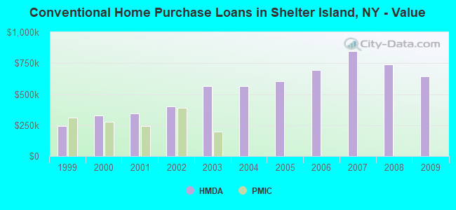
Home Mortgage Disclosure Act Aggregated Statistics For Year 2009 (Based on 1 partial tract)
A) FHA, FSA/RHS & VA Home Purchase Loans
B) Conventional Home Purchase Loans
C) Refinancings
D) Home Improvement Loans
F) Non-occupant Loans on < 5 Family Dwellings (A B C & D)
Number
Average Value
Number
Average Value
Number
Average Value
Number
Average Value
Number
Average Value
LOANS ORIGINATED
1
$171,430
7
$644,526
26
$436,778
2
$404,895
16
$562,612
APPLICATIONS APPROVED, NOT ACCEPTED
0
$0
1
$365,630
4
$1,025,648
0
$0
1
$2,013,680
APPLICATIONS DENIED
0
$0
2
$471,880
16
$683,597
1
$29,970
5
$1,023,356
APPLICATIONS WITHDRAWN
0
$0
1
$636,860
9
$410,289
0
$0
4
$401,898
FILES CLOSED FOR INCOMPLETENESS
0
$0
1
$695,600
1
$865,530
0
$0
1
$361,140
Aggregated Statistics For Year 2008 (Based on 1 partial tract)
A) FHA, FSA/RHS & VA Home Purchase Loans
B) Conventional Home Purchase Loans
C) Refinancings
D) Home Improvement Loans
F) Non-occupant Loans on < 5 Family Dwellings (A B C & D)
Number
Average Value
Number
Average Value
Number
Average Value
Number
Average Value
Number
Average Value
LOANS ORIGINATED
1
$299,100
8
$739,848
15
$661,897
4
$399,875
10
$673,276
APPLICATIONS APPROVED, NOT ACCEPTED
0
$0
0
$0
2
$749,100
0
$0
1
$164,830
APPLICATIONS DENIED
0
$0
1
$1,257,540
7
$559,411
1
$443,560
3
$477,823
APPLICATIONS WITHDRAWN
0
$0
1
$344,360
5
$436,124
0
$0
1
$314,980
FILES CLOSED FOR INCOMPLETENESS
0
$0
0
$0
1
$1,138,860
0
$0
1
$651,850
Aggregated Statistics For Year 2007 (Based on 1 partial tract)
B) Conventional Home Purchase Loans
C) Refinancings
D) Home Improvement Loans
F) Non-occupant Loans on < 5 Family Dwellings (A B C & D)
Number
Average Value
Number
Average Value
Number
Average Value
Number
Average Value
LOANS ORIGINATED
19
$849,713
19
$702,055
1
$487,310
14
$956,171
APPLICATIONS APPROVED, NOT ACCEPTED
2
$977,620
4
$767,532
1
$55,740
2
$1,334,865
APPLICATIONS DENIED
4
$1,208,240
7
$1,211,901
1
$543,060
4
$1,397,350
APPLICATIONS WITHDRAWN
1
$911,090
5
$690,928
1
$278,720
2
$1,175,275
FILES CLOSED FOR INCOMPLETENESS
1
$1,133,470
2
$431,270
0
$0
1
$763,040
Aggregated Statistics For Year 2006 (Based on 1 partial tract)
B) Conventional Home Purchase Loans
C) Refinancings
D) Home Improvement Loans
F) Non-occupant Loans on < 5 Family Dwellings (A B C & D)
Number
Average Value
Number
Average Value
Number
Average Value
Number
Average Value
LOANS ORIGINATED
16
$695,604
24
$586,563
5
$439,120
16
$763,842
APPLICATIONS APPROVED, NOT ACCEPTED
3
$745,953
4
$571,002
0
$0
1
$995,600
APPLICATIONS DENIED
2
$850,400
10
$613,186
1
$222,380
5
$732,526
APPLICATIONS WITHDRAWN
2
$817,430
8
$721,752
0
$0
2
$1,512,135
FILES CLOSED FOR INCOMPLETENESS
0
$0
4
$285,240
0
$0
1
$214,880
Aggregated Statistics For Year 2005 (Based on 1 partial tract)
B) Conventional Home Purchase Loans
C) Refinancings
D) Home Improvement Loans
E) Loans on Dwellings For 5+ Families
F) Non-occupant Loans on < 5 Family Dwellings (A B C & D)
Number
Average Value
Number
Average Value
Number
Average Value
Number
Average Value
Number
Average Value
LOANS ORIGINATED
27
$606,238
23
$450,567
4
$424,900
1
$133,370
25
$566,253
APPLICATIONS APPROVED, NOT ACCEPTED
2
$1,007,890
3
$370,530
0
$0
0
$0
2
$605,545
APPLICATIONS DENIED
6
$553,645
6
$522,327
1
$304,200
0
$0
5
$665,334
APPLICATIONS WITHDRAWN
2
$562,835
8
$290,446
2
$308,690
0
$0
3
$366,033
FILES CLOSED FOR INCOMPLETENESS
1
$194,800
6
$405,095
0
$0
0
$0
0
$0
Aggregated Statistics For Year 2004 (Based on 1 partial tract)
B) Conventional Home Purchase Loans
C) Refinancings
D) Home Improvement Loans
F) Non-occupant Loans on < 5 Family Dwellings (A B C & D)
Number
Average Value
Number
Average Value
Number
Average Value
Number
Average Value
LOANS ORIGINATED
22
$566,651
22
$348,006
6
$216,383
21
$527,272
APPLICATIONS APPROVED, NOT ACCEPTED
4
$638,285
2
$527,320
0
$0
4
$578,945
APPLICATIONS DENIED
4
$423,850
7
$520,964
1
$119,880
3
$628,770
APPLICATIONS WITHDRAWN
2
$462,735
6
$356,043
0
$0
2
$639,410
FILES CLOSED FOR INCOMPLETENESS
1
$403,700
3
$319,380
1
$90,810
0
$0
Aggregated Statistics For Year 2003 (Based on 1 partial tract)
B) Conventional Home Purchase Loans
C) Refinancings
D) Home Improvement Loans
F) Non-occupant Loans on < 5 Family Dwellings (A B C & D)
Number
Average Value
Number
Average Value
Number
Average Value
Number
Average Value
LOANS ORIGINATED
21
$567,004
75
$339,752
2
$89,460
36
$491,658
APPLICATIONS APPROVED, NOT ACCEPTED
3
$520,080
11
$262,237
0
$0
4
$477,198
APPLICATIONS DENIED
3
$348,350
15
$331,468
1
$20,980
7
$367,946
APPLICATIONS WITHDRAWN
3
$507,093
13
$298,271
0
$0
5
$471,668
FILES CLOSED FOR INCOMPLETENESS
1
$458,240
5
$289,330
1
$159,140
2
$284,265
Aggregated Statistics For Year 2002 (Based on 1 partial tract)
B) Conventional Home Purchase Loans
C) Refinancings
D) Home Improvement Loans
F) Non-occupant Loans on < 5 Family Dwellings (A B C & D)
Number
Average Value
Number
Average Value
Number
Average Value
Number
Average Value
LOANS ORIGINATED
21
$403,196
53
$318,027
2
$52,445
29
$385,208
APPLICATIONS APPROVED, NOT ACCEPTED
3
$371,030
8
$318,019
1
$148,650
5
$451,108
APPLICATIONS DENIED
4
$327,572
8
$334,915
2
$75,525
4
$345,405
APPLICATIONS WITHDRAWN
1
$1,211,690
11
$253,492
1
$113,890
3
$505,093
FILES CLOSED FOR INCOMPLETENESS
1
$607,790
1
$123,180
0
$0
1
$730,970
Aggregated Statistics For Year 2001 (Based on 1 partial tract)
B) Conventional Home Purchase Loans
C) Refinancings
D) Home Improvement Loans
F) Non-occupant Loans on < 5 Family Dwellings (A B C & D)
Number
Average Value
Number
Average Value
Number
Average Value
Number
Average Value
LOANS ORIGINATED
19
$344,466
31
$289,355
4
$54,845
18
$399,067
APPLICATIONS APPROVED, NOT ACCEPTED
2
$402,345
7
$210,517
1
$155,840
2
$389,160
APPLICATIONS DENIED
2
$273,925
10
$374,985
1
$59,940
2
$1,088,810
APPLICATIONS WITHDRAWN
1
$415,080
5
$313,486
1
$44,950
1
$440,860
FILES CLOSED FOR INCOMPLETENESS
0
$0
1
$169,030
0
$0
0
$0
Aggregated Statistics For Year 2000 (Based on 1 partial tract)
A) FHA, FSA/RHS & VA Home Purchase Loans
B) Conventional Home Purchase Loans
C) Refinancings
D) Home Improvement Loans
F) Non-occupant Loans on < 5 Family Dwellings (A B C & D)
Number
Average Value
Number
Average Value
Number
Average Value
Number
Average Value
Number
Average Value
LOANS ORIGINATED
1
$109,690
20
$327,422
13
$241,812
3
$61,737
12
$387,488
APPLICATIONS APPROVED, NOT ACCEPTED
0
$0
1
$355,440
2
$66,085
1
$95,000
1
$29,970
APPLICATIONS DENIED
0
$0
2
$192,260
4
$295,130
1
$46,150
0
$0
APPLICATIONS WITHDRAWN
0
$0
0
$0
5
$67,792
2
$29,970
0
$0
FILES CLOSED FOR INCOMPLETENESS
0
$0
0
$0
1
$143,560
0
$0
0
$0
Aggregated Statistics For Year 1999 (Based on 1 partial tract)
B) Conventional Home Purchase Loans
C) Refinancings
D) Home Improvement Loans
F) Non-occupant Loans on < 5 Family Dwellings (A B C & D)
Detailed PMIC statistics for the following Tracts:1803.00
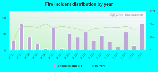
2002 - 2018 National Fire Incident Reporting System (NFIRS) incidents
Based on the data from the years 2002 - 2018 the average number of fire incidents per year is 8. The highest number of reported fire incidents - 16 took place in 2003, and the least - 1 in 2006. The data has an increasing trend.
When looking into fire subcategories, the most incidents belonged to: Structure Fires (38.9%), and Outside Fires (36.6%).
Fire incident types reported to NFIRS in Shelter Island, NY


 Recent articles from our blog. Our writers, many of them Ph.D. graduates or candidates, create easy-to-read articles on a wide variety of topics.

 (35.4 miles


 Based on the data from the years 2002 - 2018 the average number of fire incidents per year is 8. The highest number of reported fire incidents - 16 took place in 2003, and the least - 1 in 2006. The data has an increasing trend.
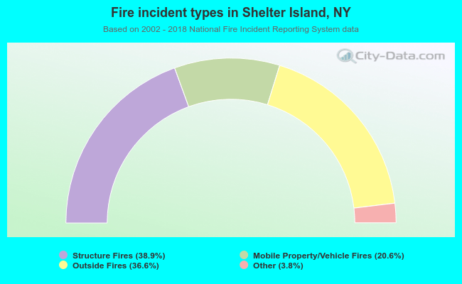 When looking into fire subcategories, the most incidents belonged to: Structure Fires (38.9%), and Outside Fires (36.6%).