Satus, Washington
Submit your own pictures of this place and show them to the world
- OSM Map
- General Map
- Google Map
- MSN Map
| Males: 425 | |
| Females: 353 |
| Median resident age: | 28.8 years |
| Washington median age: | 35.3 years |
Zip codes: 98948.
| Satus: | $58,941 |
| WA: | $91,306 |
Estimated per capita income in 2022: $17,835 (it was $9,905 in 2000)
Satus CDP income, earnings, and wages data
Estimated median house or condo value in 2022: $198,414 (it was $70,900 in 2000)
| Satus: | $198,414 |
| WA: | $569,500 |
Mean prices in 2022: all housing units: $340,866; detached houses: $376,208; townhouses or other attached units: $295,606; in 2-unit structures: $230,643; in 3-to-4-unit structures: $310,384; in 5-or-more-unit structures: $255,508; mobile homes: $163,663; occupied boats, rvs, vans, etc.: $91,300
Detailed information about poverty and poor residents in Satus, WA


- 27336.6%American Indian alone
- 23030.8%White alone
- 20527.5%Hispanic
- 314.2%Two or more races
- 20.3%Black alone
- 20.3%Asian alone
- 20.3%Other race alone
- 10.1%Native Hawaiian and Other
Pacific Islander alone
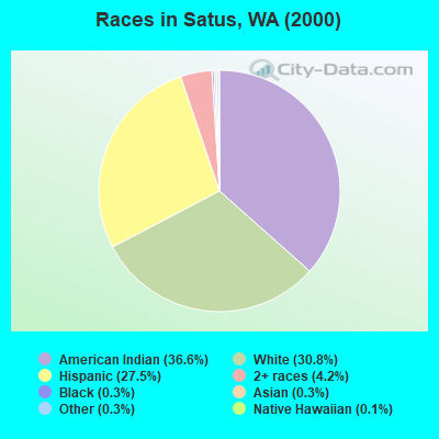
Races in Satus detailed stats: ancestries, foreign born residents, place of birth
 Recent articles from our blog. Our writers, many of them Ph.D. graduates or candidates, create easy-to-read articles on a wide variety of topics.


Latest news from Satus, WA collected exclusively by city-data.com from local newspapers, TV, and radio stations
Ancestries: German (6.6%), Italian (3.8%), English (2.4%), Irish (2.3%), Dutch (1.5%), United States (1.2%).
Current Local Time: PST time zone
Land area: 68.6 square miles.
Population density: 11 people per square mile (very low).
73 residents are foreign born (8.8% Latin America).
| This place: | 9.8% |
| Washington: | 10.4% |
| Satus CDP: | 1.3% ($905) |
| Washington: | 1.2% ($1,915) |
Nearest city with pop. 50,000+: Yakima, WA  (31.6 miles , pop. 71,845).
Nearest city with pop. 200,000+: Portland, OR (131.2 miles , pop. 529,121).
Nearest city with pop. 1,000,000+: Los Angeles, CA (845.6 miles , pop. 3,694,820).
Nearest cities:
), )Latitude: 46.24 N, Longitude: 120.12 W
Area code commonly used in this area: 509

| Here: | 7.8% |
| Washington: | 4.6% |
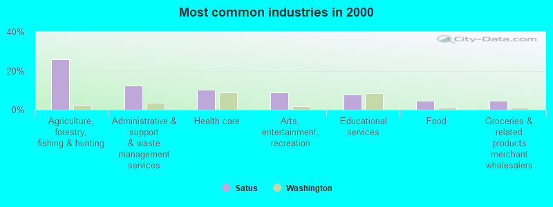
- Agriculture, forestry, fishing & hunting (25.8%)
- Administrative & support & waste management services (12.5%)
- Health care (10.3%)
- Arts, entertainment, recreation (8.9%)
- Educational services (7.7%)
- Food (4.4%)
- Groceries & related products merchant wholesalers (4.4%)
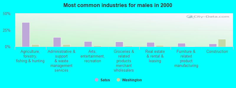
- Agriculture, forestry, fishing & hunting (36.8%)
- Administrative & support & waste management services (14.1%)
- Arts, entertainment, recreation (8.0%)
- Groceries & related products merchant wholesalers (7.4%)
- Real estate & rental & leasing (6.7%)
- Furniture & related product manufacturing (5.5%)
- Construction (4.3%)
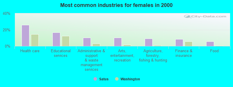
- Health care (25.9%)
- Educational services (16.7%)
- Administrative & support & waste management services (10.2%)
- Arts, entertainment, recreation (10.2%)
- Agriculture, forestry, fishing & hunting (9.3%)
- Finance & insurance (8.3%)
- Food (5.6%)
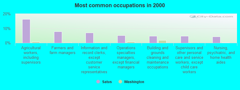
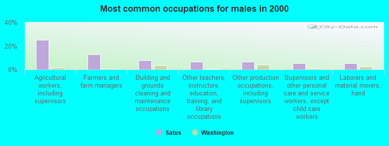
- Agricultural workers, including supervisors (16.2%)
- Farmers and farm managers (7.7%)
- Information and record clerks, except customer service representatives (7.0%)
- Operations specialties managers, except financial managers (5.2%)
- Building and grounds cleaning and maintenance occupations (4.8%)
- Supervisors and other personal care and service workers, except child care workers (4.8%)
- Nursing, psychiatric, and home health aides (4.4%)
- Agricultural workers, including supervisors (25.2%)
- Farmers and farm managers (12.9%)
- Building and grounds cleaning and maintenance occupations (8.0%)
- Other teachers, instructors, education, training, and library occupations (6.7%)
- Other production occupations, including supervisors (6.7%)
- Supervisors and other personal care and service workers, except child care workers (5.5%)
- Laborers and material movers, hand (5.5%)
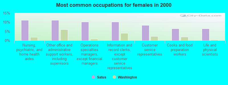
- Nursing, psychiatric, and home health aides (11.1%)
- Other office and administrative support workers, including supervisors (11.1%)
- Operations specialties managers, except financial managers (10.2%)
- Information and record clerks, except customer service representatives (10.2%)
- Customer service representatives (8.3%)
- Cooks and food preparation workers (6.5%)
- Life and physical scientists (6.5%)
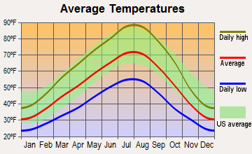
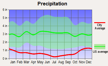
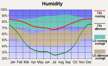
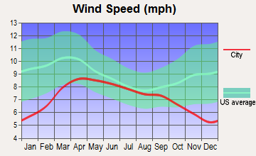
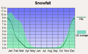
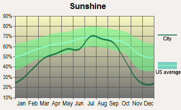
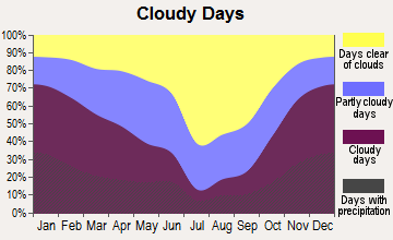
Average climate in Satus, Washington
Based on data reported by over 4,000 weather stations
(lower is better)
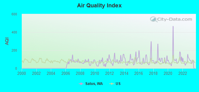
Air Quality Index (AQI) level in 2022 was 83.5. This is about average.
| City: | 83.5 |
| U.S.: | 72.6 |
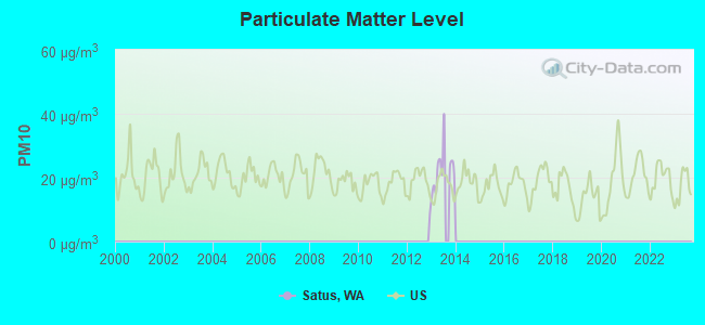
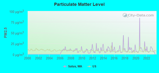
Particulate Matter (PM2.5) [µg/m3] level in 2022 was 10.7. This is worse than average. Closest monitor was 7.9 miles away from the city center.
| City: | 10.7 |
| U.S.: | 8.1 |
Earthquake activity:
Satus-area historical earthquake activity is significantly above Washington state average. It is 1398% greater than the overall U.S. average.On 4/13/1949 at 19:55:42, a magnitude 7.0 (7.0 UK, Class: Major, Intensity: VIII - XII) earthquake occurred 132.8 miles away from the city center, causing $80,000,000 total damage
On 2/28/2001 at 18:54:32, a magnitude 6.8 (6.5 MB, 6.6 MS, 6.8 MW, Class: Strong, Intensity: VII - IX) earthquake occurred 130.8 miles away from the city center, causing $2,000,000,000 total damage and $305,000,000 insured losses
On 2/28/2001 at 18:54:32, a magnitude 6.8 (6.8 MD, Depth: 32.2 mi) earthquake occurred 138.8 miles away from Satus center
On 4/29/1965 at 15:28:43, a magnitude 6.6 (6.6 UK) earthquake occurred 128.7 miles away from the city center, causing $28,000,000 total damage
On 10/28/1983 at 14:06:06, a magnitude 7.3 (6.2 MB, 7.3 MS, 7.0 MW) earthquake occurred 342.3 miles away from Satus center, causing 2 deaths (2 shaking deaths) and 3 injuries, causing $15,000,000 total damage
On 10/3/1915 at 06:52:48, a magnitude 7.6 (7.6 UK) earthquake occurred 418.2 miles away from the city center
Magnitude types: body-wave magnitude (MB), duration magnitude (MD), surface-wave magnitude (MS), moment magnitude (MW)
Natural disasters:
The number of natural disasters in Yakima County (23) is greater than the US average (15).Major Disasters (Presidential) Declared: 14
Emergencies Declared: 3
Causes of natural disasters: Floods: 10, Fires: 8, Storms: 6, Mudslides: 3, Heavy Rains: 2, Snows: 2, Winter Storms: 2, Drought: 1, Earthquake: 1, Hurricane: 1, Landslide: 1, Volcanic Eruption: 1, Wind: 1, Other: 1 (Note: some incidents may be assigned to more than one category).

Hospitals and medical centers near Satus:
- EAGLE REHABILITATION AT SUNNYSIDE (Nursing Home, about 8 miles away; SUNNYSIDE, WA)
- LOWER VALLEY HOSPICE (Hospital, about 8 miles away; SUNNYSIDE, WA)
- SUNNYSIDE COMMUNITY HOSPITAL Critical Access Hospitals (about 8 miles away; SUNNYSIDE, WA)
- MT ADAMS KIDNEY CENTER (Dialysis Facility, about 9 miles away; SUNNYSIDE, WA)
- GRANDVIEW HEALTH CARE CENTER (Nursing Home, about 10 miles away; GRANDVIEW, WA)
- WALNUT GROVE NURSING HOME (Nursing Home, about 13 miles away; GRANDVIEW, WA)
Colleges/universities with over 2000 students nearest to Satus:
- Yakima Valley Community College (about 31 miles; Yakima, WA; Full-time enrollment: 3,632)
- Columbia Basin College (about 48 miles; Pasco, WA; FT enrollment: 5,111)
- Central Washington University (about 57 miles; Ellensburg, WA; FT enrollment: 10,960)
- Wenatchee Valley College (about 84 miles; Wenatchee, WA; FT enrollment: 2,951)
- Walla Walla Community College (about 89 miles; Walla Walla, WA; FT enrollment: 4,263)
- Eastern Oregon University (about 117 miles; La Grande, OR; FT enrollment: 3,127)
- Pierce College at Puyallup (about 121 miles; Puyallup, WA; FT enrollment: 2,529)
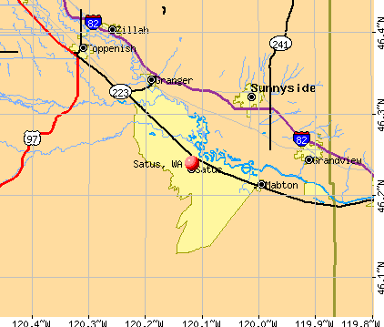
Points of interest:
Notable locations in Satus: Satus Number 3 Pumping Station (A), Empire (B), Satus Longhouse (C), Yakima County Fire District 5 Station 16 Satus (D). Display/hide their locations on the map
Church in Satus: Indian Shaker Church (A). Display/hide its location on the map
Lakes: Round Lake (A), Cockleburr Lake (B), Slaughterhouse Lake (C), Warren Lake (D), Horseshoe Lake (E). Display/hide their locations on the map
Creeks: Toppenish Creek (A), Satus Creek (B). Display/hide their locations on the map
Park in Satus: Toppenish National Wildlife Refuge (1). Display/hide its location on the map
| This place: | 3.5 people |
| Washington: | 2.5 people |
| This place: | 84.0% |
| Whole state: | 66.5% |
| This place: | 9.5% |
| Whole state: | 6.1% |
No gay or lesbian households reported
| This place: | 27.1% |
| Whole state: | 10.6% |
| This place: | 12.3% |
| Whole state: | 4.6% |
For population 15 years and over in Satus:
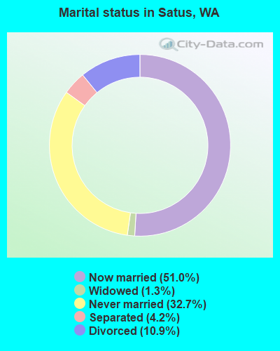
- Never married: 32.7%
- Now married: 51.0%
- Separated: 4.2%
- Widowed: 1.3%
- Divorced: 10.9%
For population 25 years and over in Satus:
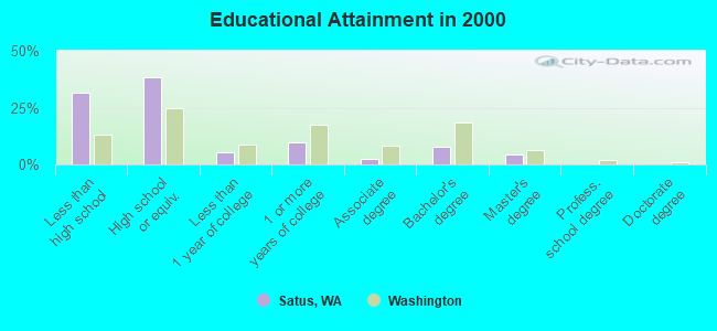
- High school or higher: 68.2%
- Bachelor's degree or higher: 12.2%
- Graduate or professional degree: 4.5%
- Unemployed: 10.6%
- Mean travel time to work (commute): 22.1 minutes
| Here: | 16.8 |
| Washington average: | 11.3 |
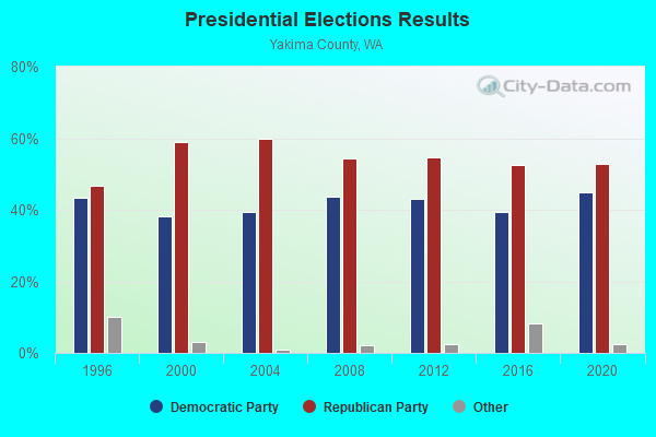
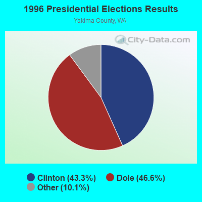
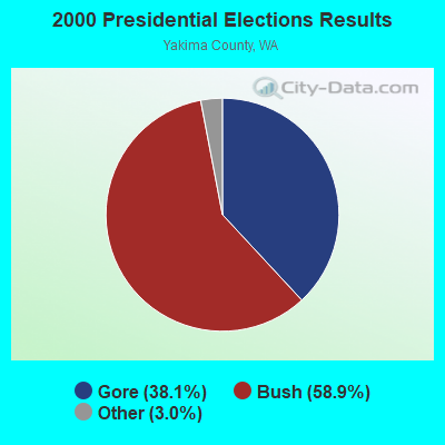
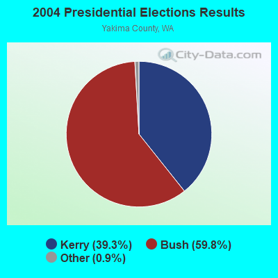

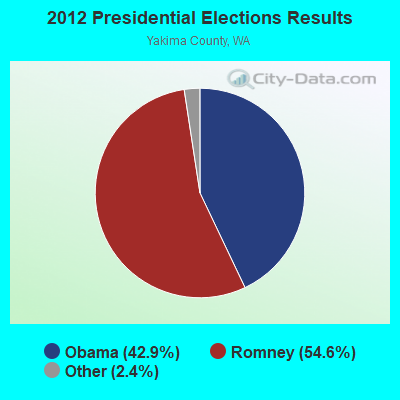
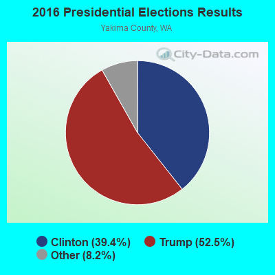
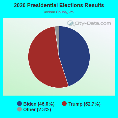
Graphs represent county-level data. Detailed 2008 Election Results
Religion statistics for Satus, WA (based on Yakima County data)
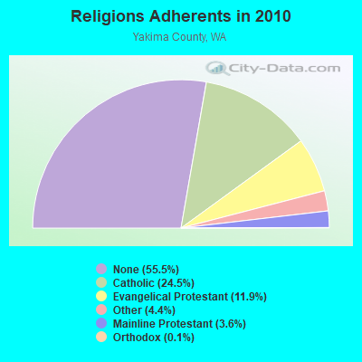
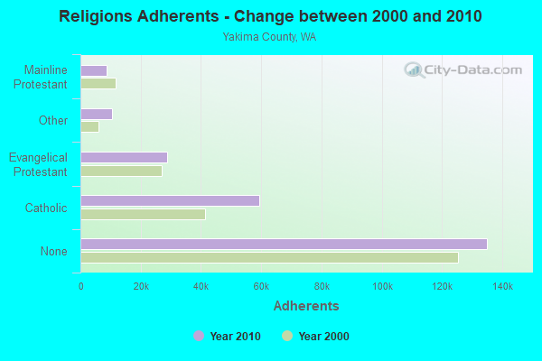
| Religion | Adherents | Congregations |
|---|---|---|
| Catholic | 59,500 | 16 |
| Evangelical Protestant | 28,841 | 175 |
| Other | 10,606 | 36 |
| Mainline Protestant | 8,802 | 48 |
| Orthodox | 250 | 1 |
| Black Protestant | 197 | 2 |
| None | 135,035 | - |
Food Environment Statistics:
| This county: | 2.24 / 10,000 pop. |
| Washington: | 2.06 / 10,000 pop. |
| Here: | 0.30 / 10,000 pop. |
| Washington: | 0.19 / 10,000 pop. |
| Here: | 0.99 / 10,000 pop. |
| State: | 1.18 / 10,000 pop. |
| Yakima County: | 3.45 / 10,000 pop. |
| Washington: | 2.67 / 10,000 pop. |
| Here: | 5.17 / 10,000 pop. |
| Washington: | 8.26 / 10,000 pop. |
| This county: | 9.2% |
| Washington: | 7.7% |
| Here: | 29.2% |
| Washington: | 25.7% |
| This county: | 17.6% |
| Washington: | 13.9% |
Strongest AM radio stations in Satus:
- KZTS (1210 AM; 10 kW; SUNNYSIDE, WA; Owner: BUTTERFIELD BROADCASTING CORPORATION)
- KZXR (1310 AM; 5 kW; PROSSER, WA; Owner: MOON BROADCASTING PROSSER LLC)
- KYAK (930 AM; 10 kW; YAKIMA, WA)
- KTBI (810 AM; daytime; 50 kW; EPHRATA, WA; Owner: TACOMA BROADCASTERS, INCORPORATED)
- KYXE (1020 AM; 5 kW; SELAH, WA; Owner: BUTTERFIELD BROADCASTING CORPORATION)
- KFLD (870 AM; 10 kW; PASCO, WA; Owner: CAPSTAR TX LIMITED PARTNERSHIP)
- KUTI (1460 AM; 5 kW; YAKIMA, WA; Owner: CITICASTERS LICENSES, L.P.)
- KBBO (1390 AM; 5 kW; YAKIMA, WA; Owner: NEW NORTHWEST BROADCASTERS, LLC)
- KIT (1280 AM; 5 kW; YAKIMA, WA; Owner: CITICASTERS LICENSES, L.P.)
- KPOJ (620 AM; 50 kW; PORTLAND, OR; Owner: CITICASTERS LICENSES, L.P.)
- KXL (750 AM; 50 kW; PORTLAND, OR; Owner: ROSE CITY RADIO CORPORATION)
- KJOX (980 AM; 5 kW; SELAH, WA; Owner: NEW NORTHWEST BROADCASTERS, LLC)
- KPAM (860 AM; 50 kW; TROUTDALE, OR; Owner: PAMPLIN BROADCASTING-OREGON, INC.)
Strongest FM radio stations in Satus:
- KLES (98.7 FM; MABTON, WA; Owner: ON-AIR FAMILY, LLC)
- KZTB (96.7 FM; SUNNYSIDE, WA; Owner: BUTTERFIELD BROADCASTING CORPORATION)
- K204DH (88.7 FM; HANFORD, WA; Owner: CALVARY CHAPEL OF TWIN FALLS, INC.)
- KARY-FM (100.9 FM; GRANDVIEW, WA; Owner: NEW NORTHWEST BROADCASTERS, LLC)
- KXDD (104.1 FM; YAKIMA, WA; Owner: NEW NORTHWEST BROADCASTERS, LLC)
- KMNA (101.7 FM; PROSSER, WA; Owner: MOON BROADCASTING PROSSER LLC)
- KFFM (107.3 FM; YAKIMA, WA; Owner: CITICASTERS LICENSES, L.P.)
- K201AS (88.1 FM; YAKIMA, WA; Owner: WEST VALLEY TRANSLATOR ASSOCIATION)
- KYPL (91.1 FM; YAKIMA, WA; Owner: GROWING CHRISTIAN FOUNDATION)
- KDBL (92.9 FM; TOPPENISH, WA; Owner: CITICASTERS LICENSES, L.P.)
- K218CX (91.5 FM; YAKIMA, WA; Owner: CALVARY CHAPEL OF TWIN FALLS, INC.)
- KHHK (99.7 FM; YAKIMA, WA; Owner: NEW NORTHWEST BROADCASTERS, LLC)
- KSOH (89.5 FM; WAPATO, WA; Owner: LIFETALK RADIO, INC.)
- KDNA (91.9 FM; YAKIMA, WA; Owner: NORTHWEST COMMUNITIES EDUC., CENTER)
- KATS (94.5 FM; YAKIMA, WA; Owner: CITICASTERS LICENSES, L.P.)
- KNWY (90.3 FM; YAKIMA, WA; Owner: WASHINGTON STATE UNIVERSITY)
- KRCW (96.3 FM; ROYAL CITY, WA; Owner: FARMWORKER EDUCATIONAL RADIO NETWORK, INC.)
- KYYT (102.3 FM; GOLDENDALE, WA; Owner: HAYSTACK BROADCASTING, INC.)
- KMCQ (104.5 FM; THE DALLES, OR; Owner: MID-COLUMBIA BROADCASTING, INC.)
- KONA-FM (105.3 FM; KENNEWICK, WA; Owner: COMMONWEALTH LICENSE SUBSIDIARY, LLC)
- Satus, Washington
- Fatal accident count8
- Vehicles involved in fatal accidents11
- Fatal accidents involving drunk persons:6
- Fatalities8
- Persons involved in fatal accidents16
- Pedestrians involved in fatal accidents2
- Washington average
- Fatal accident count4458
- Vehicles involved in fatal accidents6889
- Fatal accidents involving drunk persons1492
- Fatalities4916
- Persons involved in fatal accidents10914
- Pedestrians involved in fatal accidents859
- National Bridge Inventory (NBI) Statistics
- 12Number of bridges
- 95ft / 29.4mTotal length
- $18,028,000Total costs
- 14,878Total average daily traffic
- 2,988Total average daily truck traffic
- 20,127Total future (year 2039) average daily traffic
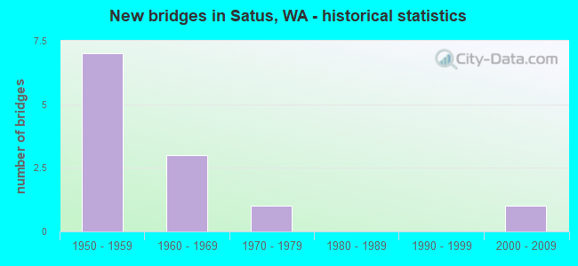
- New bridges - historical statistics
- 71950-1959
- 31960-1969
- 11970-1979
- 12000-2009
FCC Registered Broadcast Land Mobile Towers:
1- W Satus Rd & Foster Rd 4 1/2 Mi S (Lat: 46.267639 Lon: -120.187833), Call Sign: KNFG862,
Assigned Frequencies: 152.960 MHz, Grant Date: 05/22/1997, Expiration Date: 05/26/2002, Cancellation Date: 09/29/2002, Registrant: R A Rasmussen & Son Inc, Granger, WA 98932, Phone: (509) 854-1365
| Home Mortgage Disclosure Act Aggregated Statistics For Year 2009 (Based on 1 partial tract) | ||
| C) Refinancings | ||
|---|---|---|
| Number | Average Value | |
| LOANS ORIGINATED | 2 | $176,435 |
| APPLICATIONS APPROVED, NOT ACCEPTED | 0 | $0 |
| APPLICATIONS DENIED | 1 | $130,610 |
| APPLICATIONS WITHDRAWN | 1 | $129,760 |
| FILES CLOSED FOR INCOMPLETENESS | 0 | $0 |
Detailed HMDA statistics for the following Tracts: 0027.02
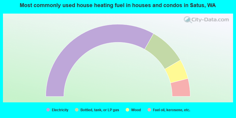
- 66.4%Electricity
- 16.8%Bottled, tank, or LP gas
- 8.8%Wood
- 8.0%Fuel oil, kerosene, etc.
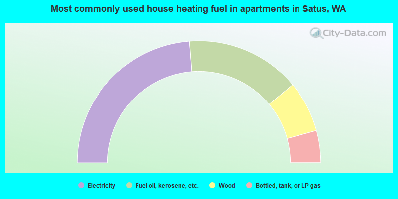
- 47.5%Electricity
- 30.5%Fuel oil, kerosene, etc.
- 13.6%Wood
- 8.5%Bottled, tank, or LP gas
Satus compared to Washington state average:
- Median household income below state average.
- Median house value significantly below state average.
- Black race population percentage significantly below state average.
- Hispanic race population percentage above state average.
- Foreign-born population percentage below state average.
- Renting percentage significantly below state average.
- Length of stay since moving in significantly above state average.
- Number of rooms per house significantly below state average.
- House age significantly below state average.
- Number of college students below state average.
- Percentage of population with a bachelor's degree or higher significantly below state average.
Satus on our top lists:
- #20 on the list of "Top 100 most racially diverse cities"
- #40 (98948) on the list of "Top 101 zip codes with the smallest percentage of taxpayers reporting profit/loss from business in 2012 (pop 5,000+)"
- #68 (98948) on the list of "Top 101 zip codes with the smallest percentage of taxpayers using charity contributions deductions in 2012 (pop 5,000+)"
- #18 on the list of "Top 101 counties with the highest number of births per 1000 residents 2007-2013"
- #33 on the list of "Top 101 counties with the lowest percentage of residents that visited a dentist within the past year"
- #35 on the list of "Top 101 counties with the lowest percentage of residents that drank alcohol in the past 30 days"
- #41 on the list of "Top 101 counties with the worst general health status score of residents (1-5), 3 years of data"
- #43 on the list of "Top 101 counties with the lowest percentage of residents relocating to other counties in 2011 (pop. 50,000+)"