Latest news from Sargent, NE collected exclusively by city-data.com from local newspapers, TV, and radio stations
Ancestries: German (24.8%), American (15.9%), Czech (15.9%), Eastern European (7.0%), European (5.1%), English (4.7%).
Current Local Time: CST time zone
Elevation: 2314 feet
Land area: 0.89 square miles.
Population density: 549 people per square mile (low).
Median real estate property taxes paid for housing units with mortgages in 2022: $1,135 (1.5%) Median real estate property taxes paid for housing units with no mortgage in 2022: $700 (1.1%)
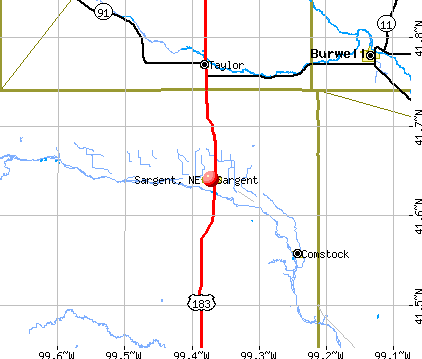
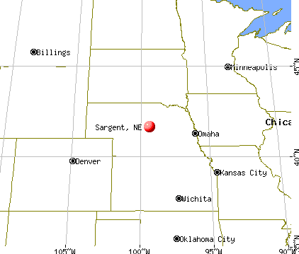
Nearest city with pop. 50,000+: Lincoln, NE (151.6 miles , pop. 225,581).
Nearest city with pop. 1,000,000+: Chicago, IL (603.1 miles , pop. 2,896,016).
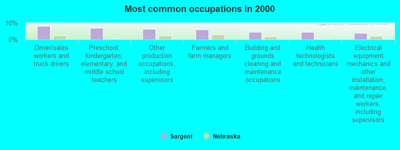
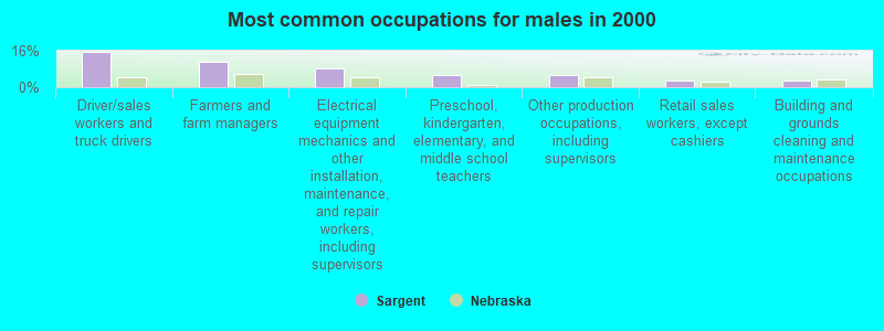
Preschool, kindergarten, elementary, and middle school teachers (6.9%)
Other production occupations, including supervisors (6.5%)
Farmers and farm managers (6.1%)
Building and grounds cleaning and maintenance occupations (4.7%)
Health technologists and technicians (4.7%)
Electrical equipment mechanics and other installation, maintenance, and repair workers, including supervisors (4.0%)
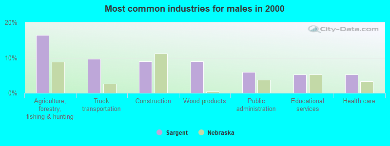
Driver/sales workers and truck drivers (15.7%)
Farmers and farm managers (11.2%)
Electrical equipment mechanics and other installation, maintenance, and repair workers, including supervisors (8.2%)
Preschool, kindergarten, elementary, and middle school teachers (5.2%)
Other production occupations, including supervisors (5.2%)
Retail sales workers, except cashiers (3.0%)
Building and grounds cleaning and maintenance occupations (3.0%)
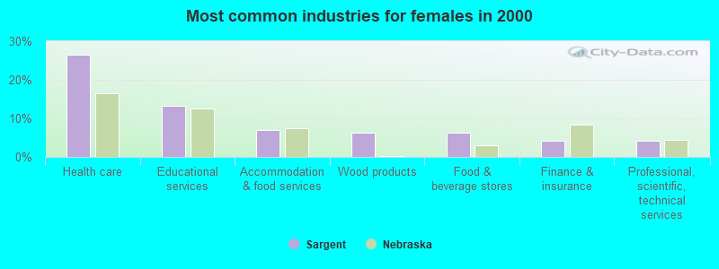
Health technologists and technicians (9.1%)
Preschool, kindergarten, elementary, and middle school teachers (8.4%)
Other production occupations, including supervisors (7.7%)
Cooks and food preparation workers (7.0%)
Secretaries and administrative assistants (7.0%)
Building and grounds cleaning and maintenance occupations (6.3%)
Registered nurses (5.6%)
Average climate in Sargent, Nebraska
Based on data reported by over 4,000 weather stations
Tornado activity:
Sargent-area historical tornado activity is slightly below Nebraska state average. It is 35% greater than the overall U.S. average.
On 6/7/1953, a category F4 (max. wind speeds 207-260 mph) tornado 17.4 miles away from the Sargent city center killed 11 peopleand causedbetween $50,000 and $500,000 in damages.
On 5/30/1961, a category F4 tornado 22.9 miles away from the city center causedbetween $50,000 and $500,000 in damages.
Earthquake activity:
Sargent-area historical earthquake activity is significantly above Nebraska state average. It is 355% greater than the overall U.S. average.
On 8/18/1959 at 06:37:13, a magnitude 7.7 (7.7 UK, Class: Major, Intensity: VIII - XII) earthquake occurred 604.0 miles away from the city center, causing $26,000,000 total damage On 11/3/2002 at 20:41:56, a magnitude 4.3 (4.3 MB, Depth: 3.1 mi, Class: Light, Intensity: IV - V) earthquake occurred 81.7 miles away from the city center On 10/18/1984 at 15:30:23, a magnitude 5.5 (5.4 MB, 5.1 MS, 5.5 ML, Class: Moderate, Intensity: VI - VII) earthquake occurred 322.6 miles away from Sargent center On 9/3/2016 at 12:02:44, a magnitude 5.8 (5.8 MW, Depth: 3.5 mi) earthquake occurred 383.8 miles away from the city center On 6/22/2019 at 08:50:24, a magnitude 4.6 (4.6 MW, Depth: 1.9 mi) earthquake occurred 167.8 miles away from the city center On 3/4/1983 at 06:32:18, a magnitude 4.6 (4.4 MB, 4.6 LG, 4.4 ML) earthquake occurred 178.0 miles away from the city center Magnitude types: regional Lg-wave magnitude (LG), body-wave magnitude (MB), local magnitude (ML), surface-wave magnitude (MS), moment magnitude (MW)
Natural disasters:
The number of natural disasters in Custer County (18) is near the US average (15). Major Disasters (Presidential) Declared: 13 Emergencies Declared: 1
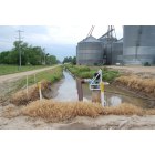
Causes of natural disasters: Storms: 11, Floods: 9, Tornadoes: 5, Winter Storms: 5, Snows: 3, Winds: 3, Hurricane: 1, Ice Storm: 1, Other: 1 (Note: some incidents may be assigned to more than one category).
Hospitals and medical centers in Sargent:
GOLI MEDICAL CENTER (provides emergency services, 1201 WEST MAIN RR1 BOX 11)
SARGENT TOWNSHIP LIBRARY (Operating income: $14,687; Location: 504 MAIN STREET; 8,380 books; 145 audio materials; 473 video materials; 1 local licensed databases; 20 state licensed databases; 12 print serial subscriptions)
User-submitted facts and corrections:
New Police Salary is 33,500 I was the police chief from 1999-2004, There is a wonderful 9 hole golf course, great schools, and a new 2006 community center added by Opie
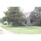
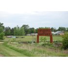
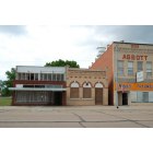
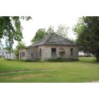
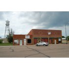
Notable locations in Sargent: Farmers Cooperative Elevator (A), Sargent Golden Acres RV Park (B), Sargent Feed and Grain Company Elevator (C), Sargent Volunteer Fire Department (D), Sargent Library (E), Sargent Ambulance Service (F). Display/hide their locations on the map
Churches in Sargent include: Evangelical Free Church (A), Church of Christ (B), Peace Lutheran Church (C), United Methodist Church (D), Assumption of Blessed Virgin Mary Church (E). Display/hide their locations on the map
Hotel: Drakes Sunset Motel (302 North Highway 183).
Custer County has a predicted average indoor radon screening level between 2 and 4 pCi/L (pico curies per liter) - Moderate Potential
Drinking water stations with addresses in Sargent and their reported violations in the past:
SARGENT, CITY OF (Population served: 577, Groundwater):
Past health violations:
MCL, Monthly (TCR) - In MAR-2014, Contaminant: Coliform. Follow-up actions: St Public Notif requested (APR-11-2014), St Violation/Reminder Notice (APR-11-2014), St Public Notif received (MAY-02-2014)
MCL, Monthly (TCR) - In NOV-2011, Contaminant: Coliform. Follow-up actions: St Public Notif requested (DEC-02-2011), St Violation/Reminder Notice (DEC-02-2011), St Public Notif received (DEC-14-2011)
MCL, Monthly (TCR) - In MAR-2005, Contaminant: Coliform. Follow-up actions: St Public Notif requested (APR-01-2005), St Violation/Reminder Notice (APR-01-2005), St Public Notif received (APR-13-2005)
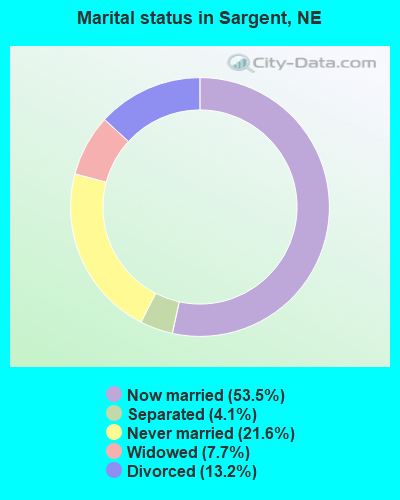
Average household size:
This city:
2.1 people
Nebraska:
2.5 people
Percentage of family households:
This city:
60.4%
Whole state:
64.8%
Percentage of households with unmarried partners:
This city:
4.5%
Whole state:
6.0%
Likely homosexual households (counted as self-reported same-sex unmarried-partner households)
Lesbian couples: 0.4% of all households
Gay men: 0.4% of all households
40 people in nursing homes in 2000
Banks with branches in Sargent (2011 data):
First National Bank in Ord: Sargent Branch at 315 West Main Street, branch established on 1910/01/01. Info updated 2006/11/03: Bank assets: $93.6 mil, Deposits: $79.2 mil, headquarters in Ord, NE, positive income, Agricultural Specialization, 2 total offices, Holding Company: Bbj Incorporated
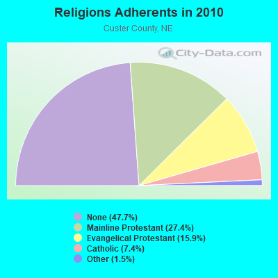
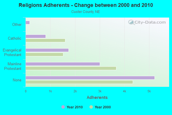
Religion statistics for Sargent, NE (based on Custer County data)
Religion
Adherents
Congregations
Mainline Protestant
3,002
18
Evangelical Protestant
1,741
21
Catholic
809
4
Other
165
2
None
5,222
-
Source: Clifford Grammich, Kirk Hadaway, Richard Houseal, Dale E.Jones, Alexei Krindatch, Richie Stanley and Richard H.Taylor. 2012. 2010 U.S.Religion Census: Religious Congregations & Membership Study. Association of Statisticians of American Religious Bodies. Jones, Dale E., et al. 2002. Congregations and Membership in the United States 2000. Nashville, TN: Glenmary Research Center. Graphs represent county-level data
Hwy 183 5 Mi N (Lat: 41.705000 Lon: -99.372056), Call Sign: KOB698, Assigned Frequencies: 463.025 MHz, 463.050 MHz, 463.075 MHz, 463.100 MHz, 463.125 MHz, 463.150 MHz, 463.175 MHz, 468.000 MHz, 468.025 MHz, 468.050 MHz... (+5 more), Grant Date: 02/14/2023, Expiration Date: 02/12/2033, Registrant: Platte Valley Communications Of Kearney, 2215 Ave I, Kearney, NE 68848, Phone: (308) 237-9512, Fax: (308) 236-5728, Email:
Hwy 183 5 Mi N (Lat: 41.705000 Lon: -99.372056), Call Sign: WDD527, Assigned Frequencies: 468.000 MHz, 468.025 MHz, 468.050 MHz, 468.075 MHz, 468.100 MHz, 468.125 MHz, 468.150 MHz, 468.175 MHz, Grant Date: 02/14/2023, Expiration Date: 02/12/2033, Registrant: Platte Valley Communications Of Kearney, 2215 Ave I, Kearney, NE 68848, Phone: (308) 237-9512, Fax: (308) 236-5728, Email:
City Water Tower N First St (Lat: 41.650000 Lon: -99.383722), Call Sign: KAN802, Assigned Frequencies: 153.710 MHz, Grant Date: 12/23/2004, Expiration Date: 01/31/2015, Cancellation Date: 04/04/2015, Registrant: Sargent Irrigation District, 402 N 1st St., Sargent, NE 68874, Phone: (308) 527-4216, Fax: (308) 527-9101, Email:
South School Land (Lat: 41.701667 Lon: -99.505833), Type: Mast, Structure height: 2.4 m, Call Sign: WQTY844, Assigned Frequencies: 154.555 MHz, Grant Date: 05/08/2014, Expiration Date: 05/08/2024, Certifier: Bernard Ritchie, Registrant: Cara Enterprises Inc, Las Vegas, NV 89140-0124, Phone: (702) 838-9728, Fax: (702) 363-4607, Email:
Lat: 41.638333 Lon: -99.365028, Call Sign: WRBQ448, Assigned Frequencies: 451.775 MHz, Grant Date: 05/21/2018, Expiration Date: 05/21/2028, Certifier: Nick Ernesti, Registrant: Electronic Engineering Co, 1100 Keo Way, Des Moines, IA 50309, Phone: (515) 283-1100, Fax: (515) 244-6948, Email:
FCC Registered Microwave Towers:
7
Sargent, 8 Km North Of Sargent On Hwy 183 (Lat: 41.702222 Lon: -99.372056), Type: Tower, Structure height: 103.6 m, Call Sign: WQBS549, Assigned Frequencies: 955.150 MHz, Grant Date: 11/27/2014, Expiration Date: 12/06/2024, Certifier: Richard D Nelson, Registrant: Haggerty Communication Group, 7840 El Cajon Blvd. Suite 401, La Mesa, CA 91941, Phone: (619) 698-9560, Fax: (619) 698-9574, Email:
Sargent, Lat: 41.637083 Lon: -99.371917, Type: Ltower, Structure height: 38.1 m, Overall height: 39.6 m, Call Sign: WQUP435, Assigned Frequencies: 3650.00 MHz, Grant Date: 09/03/2014, Expiration Date: 09/03/2024, Cancellation Date: 01/03/2023, Certifier: Thomas W Burnett, Registrant: Ne Colorado Cellular, Inc., 1224 West Platte Avenue, Fort Morgan, CO 80701, Phone: (970) 542-3667, Fax: (970) 867-3589, Email:
Sargent, Lat: 41.637083 Lon: -99.371917, Type: Ltower, Structure height: 38.1 m, Overall height: 39.6 m, Call Sign: WQUP435, Assigned Frequencies: 3650.00 MHz, Grant Date: 09/03/2014, Expiration Date: 09/03/2024, Cancellation Date: 01/03/2023, Certifier: Thomas W Burnett, Registrant: Ne Colorado Cellular, Inc., 1224 West Platte Avenue, Fort Morgan, CO 80701, Phone: (970) 542-3667, Fax: (970) 867-3589, Email:
Sargent, Lat: 41.637083 Lon: -99.371917, Type: Ltower, Structure height: 38.1 m, Overall height: 39.6 m, Call Sign: WQUP435, Assigned Frequencies: 3650.00 MHz, Grant Date: 09/03/2014, Expiration Date: 09/03/2024, Cancellation Date: 01/03/2023, Certifier: Thomas W Burnett, Registrant: Ne Colorado Cellular, Inc., 1224 West Platte Avenue, Fort Morgan, CO 80701, Phone: (970) 542-3667, Fax: (970) 867-3589, Email:
NE-SARGENT, Jessie Street & Broadway Street (Lat: 41.637083 Lon: -99.371917), Type: Ltower, Structure height: 38.1 m, Overall height: 39.6 m, Call Sign: WQZQ787, Assigned Frequencies: 6226.89 MHz, 6256.54 MHz, 10875.0 MHz, 10915.0 MHz, 10875.0 MHz, 10915.0 MHz, 6226.89 MHz, 6256.54 MHz, 10875.0 MHz, 10915.0 MHz... (+58 more), Grant Date: 07/11/2017, Expiration Date: 07/11/2027, Certifier: Thomas W Burnett, Registrant: Ne Colorado Cellular, Inc., 1220 West Platte Ave, Fort Morgan, CO 80701, Phone: (970) 867-6767, Fax: (970) 867-3589, Email:
Taylor Region 26, 8 Km North Of Sargent On Hwy 183 (Lat: 41.702222 Lon: -99.372056), Type: Gtower, Structure height: 103.6 m, Call Sign: WRHR852, Assigned Frequencies: 10995.0 MHz, 10795.0 MHz, 6004.50 MHz, 10995.0 MHz, 10795.0 MHz, 6004.50 MHz, 10995.0 MHz, 10795.0 MHz, 6004.50 MHz, 10995.0 MHz... (+8 more), Grant Date: 06/04/2020, Expiration Date: 06/04/2030, Certifier: Doug Fox, Registrant: Platte Valley Communications, Inc, 2215 Ave I, Keanrey, NE 68848, Phone: (308) 237-9512, Fax: (308) 236-5278, Email:
STATION, 5 Miles N On Highway 183 (Lat: 41.702222 Lon: -99.372028), Overall height: 91.1 m, Call Sign: WHP32, Assigned Frequencies: 956.600 MHz, 956.800 MHz, Grant Date: 03/05/2008, Expiration Date: 02/04/2018, Cancellation Date: 04/14/2018, Registrant: Region 26 Council, Taylor, NE 68879, Phone: (308) 942-3461
FCC Registered Amateur Radio Licenses:
6
Call Sign: K0UDB, Licensee ID: L01473382, Grant Date: 03/10/2009, Expiration Date: 03/02/2019, Cancellation Date: 03/03/2021, Certifier: Gaylord B Ottun, Registrant: Gaylord B Ottun, 81036 Road 446, Sargent, NE 68874
Call Sign: KA0LAR, Licensee ID: L00274251, Grant Date: 09/07/2006, Expiration Date: 08/13/2016, Cancellation Date: 08/14/2018, Certifier: Daniel L Tinkham, Registrant: Daniel L Tinkham, 408 N 2nd, Sargent, NE 68874
Call Sign: KA0LAS, Licensee ID: L01190050, Grant Date: 09/07/2006, Expiration Date: 08/13/2016, Cancellation Date: 08/14/2018, Certifier: Edith C Tinkham, Registrant: Edith C Tinkham, 408 N 2nd, Sargent, NE 68874
Call Sign: KB0DEH, Grant Date: 06/15/1998, Expiration Date: 06/15/2008, Cancellation Date: 06/16/2010, Registrant: Michael D Cook, 206 N Second Box 22, Sargent, NE 68874
Call Sign: KE0RRQ, Licensee ID: L02179347, Grant Date: 05/11/2018, Expiration Date: 05/11/2028, Certifier: Daniel D Vincent, Registrant: Daniel D Vincent, 1002 W Main St, Sargent, NE 68874
Call Sign: KE0YVA, Licensee ID: L02314399, Grant Date: 12/27/2019, Expiration Date: 12/27/2029, Certifier: Jason C Schwarting, Registrant: Jason C Schwarting, 207 W Semler, Sargent, NE 68874
FAA Registered Aircraft:
6
Aircraft: CESSNA 180 (Category: Land, Seats: 4, Weight: Up to 12,499 Pounds, Speed: 121 mph), Engine: CONT MOTOR O-470 SERIES (230 HP) (Reciprocating) N-Number: 1725C, N1725C, N-1725C, Serial Number: 30425, Year manufactured: 1953, Airworthiness Date: 05/25/1956, Certificate Issue Date: 11/15/2006 Registrant (Individual): Elizabeth A Poland, 204 S 2nd St, Sargent, NE 68874
Aircraft: CESSNA 172G (Category: Land, Seats: 4, Weight: Up to 12,499 Pounds, Speed: 105 mph), Engine: CONT MOTOR 0-300 SER (145 HP) (Reciprocating) N-Number: 3866L, N3866L, N-3866L, Serial Number: 17254035, Year manufactured: 1966, Airworthiness Date: 01/06/1966, Certificate Issue Date: 04/08/2019 Registrant (Individual): Daniel A Lamb, 102 N Highway 183, Sargent, NE 68874
Aircraft: PIPER PA-31-310 (Category: Land, Engines: 2, Seats: 8, Weight: Up to 12,499 Pounds, Speed: 162 mph), Engine: LYCOMING TI0-540 SER (310 HP) (Reciprocating) N-Number: 412TM, N412TM, N-412TM, Serial Number: 31-510, Year manufactured: 1969, Airworthiness Date: 08/02/1988, Certificate Issue Date: 03/31/2005 Registrant (LLC): Flying J Aviation LLC, 45100 Weissert Rd, Sargent, NE 68874
Aircraft: CESSNA 140 (Category: Land, Seats: 2, Weight: Up to 12,499 Pounds, Speed: 105 mph), Engine: CONT MOTOR C85 SERIES (85 HP) (Reciprocating) N-Number: 4290N, N4290N, N-4290N, Serial Number: 13761, Year manufactured: 1947, Airworthiness Date: 11/27/1953, Certificate Issue Date: 02/15/2012 Registrant (Corporation): Albion Aerial Sprayers Inc, 45100 Weissert Rd, Sargent, NE 68874
Aircraft: CESSNA 172N (Category: Land, Seats: 4, Weight: Up to 12,499 Pounds, Speed: 105 mph), Engine: LYCOMING 0-320 SERIES (180 HP) (Reciprocating) N-Number: 738RA, N738RA, N-738RA, Serial Number: 17270168, Year manufactured: 1977, Airworthiness Date: 01/13/1978, Certificate Issue Date: 06/11/1998 Registrant (LLC): Flying J Aviation LLC, 45100 Weissert Rd, Sargent, NE 68874
Aircraft: CESSNA 172N (Category: Land, Seats: 4, Weight: Up to 12,499 Pounds, Speed: 105 mph), Engine: LYCOMING 0-320 SERIES (180 HP) (Reciprocating) N-Number: 75778, N75778, N-75778, Serial Number: 17267943, Year manufactured: 1976, Airworthiness Date: 10/15/1976, Certificate Issue Date: 04/06/2012 Registrant (Co-Owned): Gregory S Kissell, 44921 Sargent Rd, Sargent, NE 68874, Other Owners: Aletha S G Kissell
Most common first names in Sargent, NE among deceased individuals
Name
Count
Lived (average)
William
17
76.8 years
Mary
13
85.4 years
Anna
11
84.0 years
James
11
74.0 years
John
10
78.5 years
Charles
10
76.6 years
Frank
10
82.0 years
George
10
79.5 years
Dorothy
9
79.3 years
Florence
8
84.1 years
Most common last names in Sargent, NE among deceased individuals


 Recent articles from our blog. Our writers, many of them Ph.D. graduates or candidates, create easy-to-read articles on a wide variety of topics.

 (151.6 miles