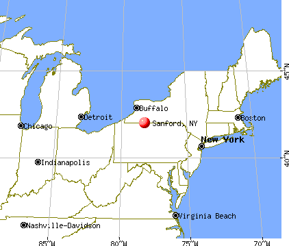
Sanford, New York
Submit your own pictures of this town and show them to the world
- OSM Map
- General Map
- Google Map
- MSN Map
Population change since 2000: -2.8%
 |
| Males: 1,210 | |
| Females: 1,197 |
| Median resident age: | 45.2 years |
| New York median age: | 40.7 years |
Zip codes: 13754.
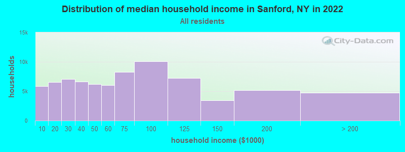
| Sanford: | $57,121 |
| NY: | $79,557 |
Estimated per capita income in 2022: $29,422 (it was $17,083 in 2000)
Sanford town income, earnings, and wages data
Estimated median house or condo value in 2022: $139,782 (it was $70,800 in 2000)
| Sanford: | $139,782 |
| NY: | $400,400 |
Mean prices in 2022: all housing units: $180,458; detached houses: $178,249; townhouses or other attached units: $268,846; in 2-unit structures: $138,144; in 3-to-4-unit structures: $139,592; in 5-or-more-unit structures: $758,756; mobile homes: $62,903
Detailed information about poverty and poor residents in Sanford, NY


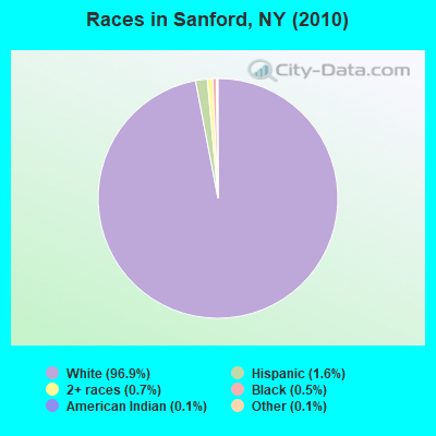
- 2,33396.9%White alone
- 381.6%Hispanic
- 160.7%Two or more races
- 120.5%Black alone
- 30.1%American Indian alone
- 30.1%Other race alone
- 20.08%Asian alone
Races in Sanford detailed stats: ancestries, foreign born residents, place of birth
 Recent articles from our blog. Our writers, many of them Ph.D. graduates or candidates, create easy-to-read articles on a wide variety of topics.

 | Upper Middle class african-american communities in ny (2044 replies) |
| Letitia James get booed at FDNY ceremony (159 replies) |
| For those interested in Binghamton development/news/events, etc... (424 replies) |
| How did the NYC anti-Asian violence disappear all of a sudden? (57 replies) |
| Safest Cities from natural disasters (70 replies) |
| Syracuse, NY Highly Rated and Ranked (43 replies) |
Latest news from Sanford, NY collected exclusively by city-data.com from local newspapers, TV, and radio stations
Ancestries: German (21.2%), English (16.6%), Irish (15.7%), Italian (12.6%), United States (12.0%), Dutch (4.6%).
Current Local Time: EST time zone
Land area: 90.1 square miles.
Population density: 27 people per square mile (very low).
55 residents are foreign born (1.8% Europe, 0.4% North America).
| This town: | 2.2% |
| New York: | 20.4% |
| Sanford town: | 1.8% ($1,286) |
| New York: | 1.9% ($2,847) |
Nearest city with pop. 50,000+: Union, NY (27.9 miles  , pop. 56,298).
Nearest city with pop. 200,000+: Newark, NJ (114.8 miles , pop. 273,546).
Nearest city with pop. 1,000,000+: Bronx, NY (119.3 miles , pop. 1,332,650).
Nearest cities:
), ), ), ), ), Latitude: 42.08 N, Longitude: 75.48 W
Area code commonly used in this area: 607

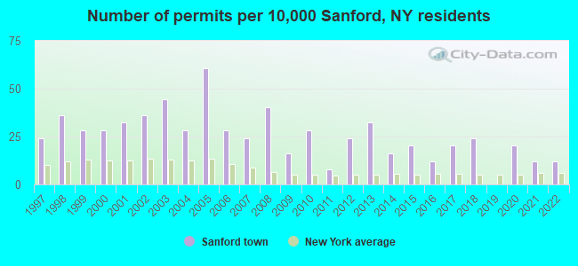
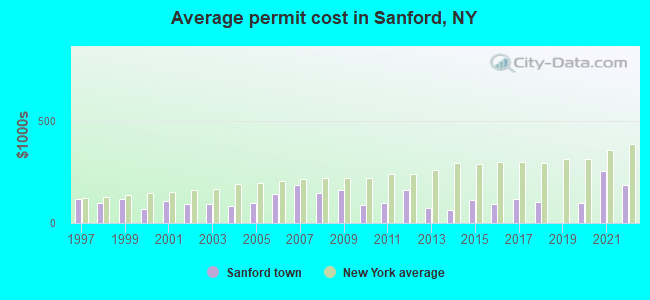
Single-family new house construction building permits:
- 2022: 3 buildings, average cost: $186,700
- 2021: 3 buildings, average cost: $251,700
- 2020: 5 buildings, average cost: $97,000
- 2018: 6 buildings, average cost: $103,600
- 2017: 5 buildings, average cost: $117,000
- 2016: 3 buildings, average cost: $94,000
- 2015: 5 buildings, average cost: $111,200
- 2014: 4 buildings, average cost: $65,300
- 2013: 8 buildings, average cost: $74,100
- 2012: 6 buildings, average cost: $161,700
- 2011: 2 buildings, average cost: $100,000
- 2010: 7 buildings, average cost: $86,300
- 2009: 4 buildings, average cost: $160,000
- 2008: 10 buildings, average cost: $145,200
- 2007: 6 buildings, average cost: $187,000
- 2006: 7 buildings, average cost: $139,600
- 2005: 15 buildings, average cost: $97,800
- 2004: 7 buildings, average cost: $83,400
- 2003: 11 buildings, average cost: $93,200
- 2002: 9 buildings, average cost: $95,200
- 2001: 8 buildings, average cost: $107,500
- 2000: 7 buildings, average cost: $67,100
- 1999: 7 buildings, average cost: $117,400
- 1998: 9 buildings, average cost: $95,800
- 1997: 6 buildings, average cost: $118,300
| Here: | 4.7% |
| New York: | 4.4% |
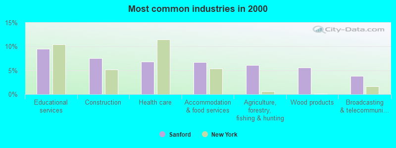
- Educational services (9.5%)
- Construction (7.5%)
- Health care (6.8%)
- Accommodation & food services (6.7%)
- Agriculture, forestry, fishing & hunting (6.1%)
- Wood products (5.6%)
- Broadcasting & telecommunications (3.8%)
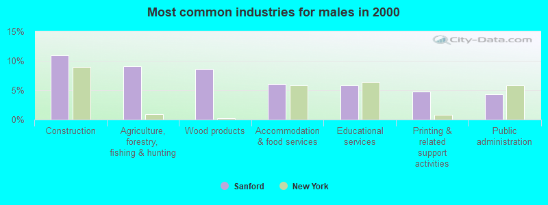
- Construction (10.9%)
- Agriculture, forestry, fishing & hunting (9.1%)
- Wood products (8.6%)
- Accommodation & food services (6.1%)
- Educational services (5.8%)
- Printing & related support activities (4.8%)
- Public administration (4.3%)
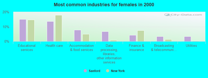
- Educational services (15.0%)
- Health care (13.6%)
- Accommodation & food services (7.7%)
- Data processing, libraries, other information services (6.8%)
- Finance & insurance (4.2%)
- Broadcasting & telecommunications (3.3%)
- Utilities (3.3%)
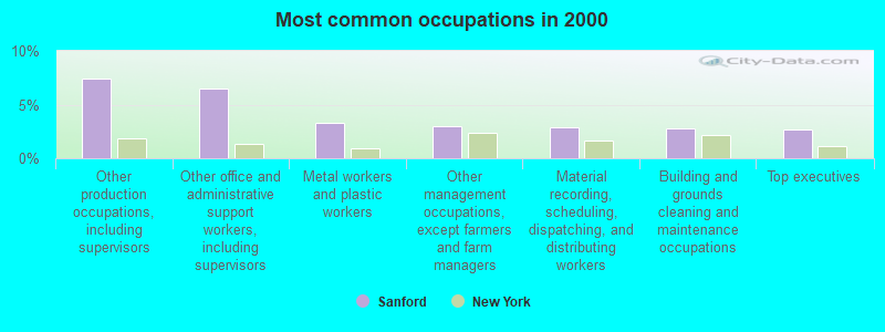
- Other production occupations, including supervisors (7.4%)
- Other office and administrative support workers, including supervisors (6.5%)
- Metal workers and plastic workers (3.3%)
- Other management occupations, except farmers and farm managers (2.9%)
- Material recording, scheduling, dispatching, and distributing workers (2.9%)
- Building and grounds cleaning and maintenance occupations (2.8%)
- Top executives (2.7%)
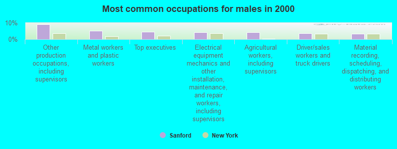
- Other production occupations, including supervisors (9.0%)
- Metal workers and plastic workers (5.1%)
- Top executives (4.5%)
- Electrical equipment mechanics and other installation, maintenance, and repair workers, including supervisors (4.2%)
- Agricultural workers, including supervisors (4.2%)
- Driver/sales workers and truck drivers (3.5%)
- Material recording, scheduling, dispatching, and distributing workers (3.4%)
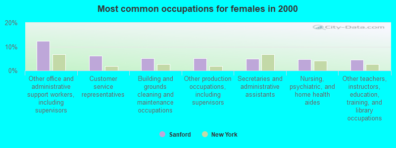
- Other office and administrative support workers, including supervisors (12.4%)
- Customer service representatives (6.1%)
- Building and grounds cleaning and maintenance occupations (5.2%)
- Other production occupations, including supervisors (5.2%)
- Secretaries and administrative assistants (4.9%)
- Nursing, psychiatric, and home health aides (4.7%)
- Other teachers, instructors, education, training, and library occupations (4.4%)
Average climate in Sanford, New York
Based on data reported by over 4,000 weather stations


Tornado activity:
Sanford-area historical tornado activity is near New York state average. It is 60% smaller than the overall U.S. average.
On 5/31/1998, a category F3 (max. wind speeds 158-206 mph) tornado 24.6 miles away from the Sanford town center injured 12 people and caused $3 million in damages.
On 5/31/1998, a category F3 tornado 36.6 miles away from the town center injured 3 people and caused $800,000 in damages.
Earthquake activity:
Sanford-area historical earthquake activity is significantly above New York state average. It is 66% smaller than the overall U.S. average.On 10/7/1983 at 10:18:46, a magnitude 5.3 (5.1 MB, 5.3 LG, 5.1 ML, Class: Moderate, Intensity: VI - VII) earthquake occurred 141.7 miles away from the city center
On 4/20/2002 at 10:50:47, a magnitude 5.3 (5.3 ML, Depth: 3.0 mi) earthquake occurred 190.6 miles away from the city center
On 4/20/2002 at 10:50:47, a magnitude 5.2 (5.2 MB, 4.2 MS, 5.2 MW, 5.0 MW) earthquake occurred 188.6 miles away from Sanford center
On 8/23/2011 at 17:51:04, a magnitude 5.8 (5.8 MW, Depth: 3.7 mi) earthquake occurred 316.5 miles away from the city center
On 1/16/1994 at 01:49:16, a magnitude 4.6 (4.6 MB, 4.6 LG, Depth: 3.1 mi, Class: Light, Intensity: IV - V) earthquake occurred 124.5 miles away from the city center
On 9/25/1998 at 19:52:52, a magnitude 5.2 (4.8 MB, 4.3 MS, 5.2 LG, 4.5 MW, Depth: 3.1 mi) earthquake occurred 256.8 miles away from Sanford center
Magnitude types: regional Lg-wave magnitude (LG), body-wave magnitude (MB), local magnitude (ML), surface-wave magnitude (MS), moment magnitude (MW)
Natural disasters:
The number of natural disasters in Broome County (25) is a lot greater than the US average (15).Major Disasters (Presidential) Declared: 15
Emergencies Declared: 8
Causes of natural disasters: Floods: 11, Storms: 11, Snowstorms: 3, Tropical Storms: 3, Heavy Rains: 2, Hurricanes: 2, Tornadoes: 2, Blizzard: 1, Landslide: 1, Power Outage: 1, Tropical Depression: 1, Wind: 1, Winter Storm: 1, Other: 2 (Note: some incidents may be assigned to more than one category).
Colleges/universities with over 2000 students nearest to Sanford:
- SUNY Broome Community College (about 23 miles; Binghamton, NY; Full-time enrollment: 4,969)
- SUNY at Binghamton (about 26 miles; Vestal, NY; FT enrollment: 15,096)
- SUNY College of Technology at Delhi (about 32 miles; Delhi, NY; FT enrollment: 2,911)
- SUNY Oneonta (about 35 miles; Oneonta, NY; FT enrollment: 6,081)
- Marywood University (about 46 miles; Scranton, PA; FT enrollment: 2,959)
- University of Scranton (about 48 miles; Scranton, PA; FT enrollment: 5,488)
- Tompkins Cortland Community College (about 51 miles; Dryden, NY; FT enrollment: 3,884)
Points of interest:
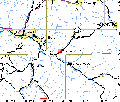
Notable locations in Sanford: Kellystone Park (A), Initial Monument (B), Camp Amahami (C), Baxters Tree Farm And Nursery (D), Scotts Golf Course (E), State Theatre (F), Deposit Village Hall (G), Deposit Free Library (H). Display/hide their locations on the map
Churches in Sanford include: First Presbyterian Church (A), First United Methodist Church (B), Saint Joseph's Roman Catholic Church (C), Gulf Summit Church (D), North Sanford United Methodist Church (E), McClure United Methodist Church (F). Display/hide their locations on the map
Cemeteries: Saint Josephs Cemetery (1), Lord Road Cemetery (2), Danville Cemetery (3), McClure Cemetery (4), Sanford Cemetery (5), Loomis Hill Cemetery (6), Arctic Cemetery (7). Display/hide their locations on the map
Lakes, reservoirs, and swamps: Laurel Lake (A), Marsh Pond (B), Oquaga Lake (C), Page Pond (D), Palmers Pond (E), Stilson Pond (F), Summit Lake (G), Beaver Pond (H). Display/hide their locations on the map
Streams, rivers, and creeks: Butler Brook (A), Fly Creek (B), Page Pond Brook (C), Bone Creek (D), Dry Brook (E), Tarbell Brook (F), Sherman Creek (G), Oquaga Creek (H), Marsh Creek (I). Display/hide their locations on the map
Birthplace of: Bert Lord - Politician.
| This town: | 2.5 people |
| New York: | 2.6 people |
| This town: | 69.5% |
| Whole state: | 63.5% |
| This town: | 6.4% |
| Whole state: | 6.8% |
Likely homosexual households (counted as self-reported same-sex unmarried-partner households)
- Lesbian couples: 0.3% of all households
- Gay men: 0.7% of all households
| This town: | 15.6% |
| Whole state: | 14.6% |
| This town: | 7.8% |
| Whole state: | 7.4% |
For population 15 years and over in Sanford:
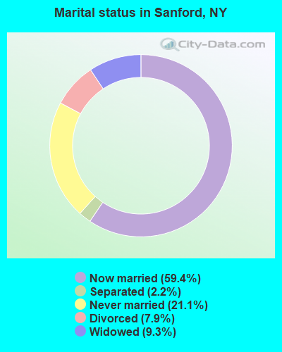
- Never married: 21.1%
- Now married: 59.4%
- Separated: 2.2%
- Widowed: 9.3%
- Divorced: 7.9%
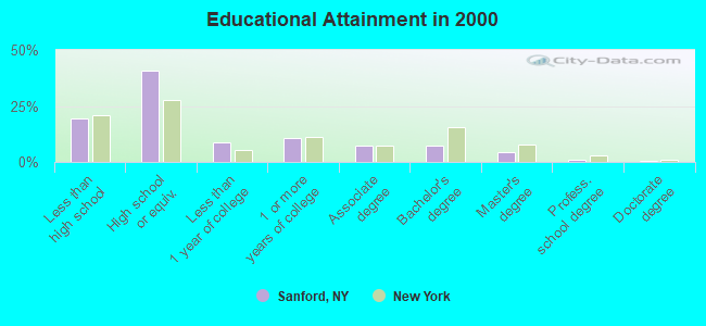
For population 25 years and over in Sanford:
- High school or higher: 80.4%
- Bachelor's degree or higher: 12.7%
- Graduate or professional degree: 5.6%
- Unemployed: 6.4%
- Mean travel time to work (commute): 26.1 minutes
| Here: | 10.3 |
| New York average: | 14.2 |
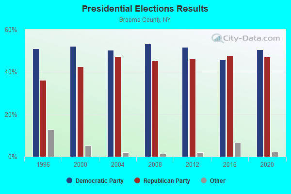
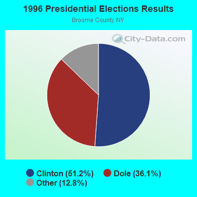
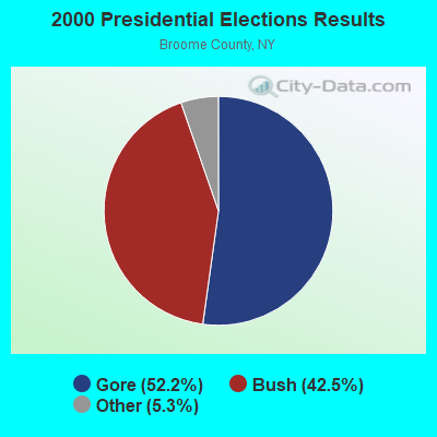
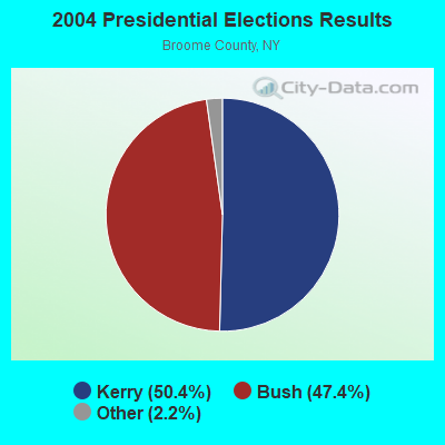
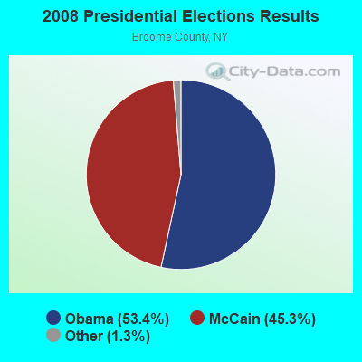
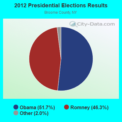
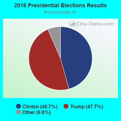
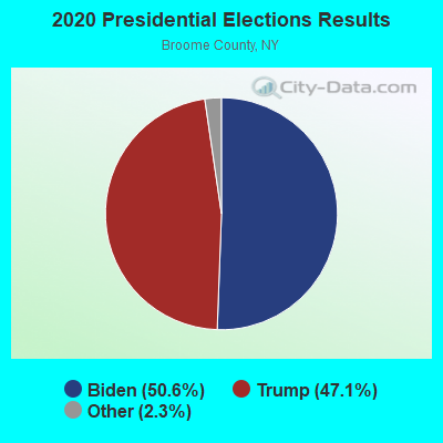
Graphs represent county-level data. Detailed 2008 Election Results
Religion statistics for Sanford, NY (based on Broome County data)
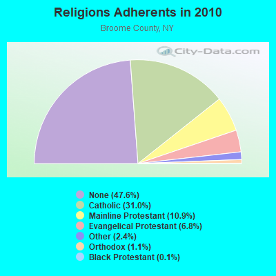
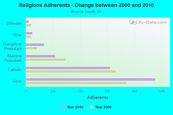
| Religion | Adherents | Congregations |
|---|---|---|
| Catholic | 62,220 | 34 |
| Mainline Protestant | 21,823 | 82 |
| Evangelical Protestant | 13,541 | 84 |
| Other | 4,900 | 18 |
| Orthodox | 2,285 | 9 |
| Black Protestant | 295 | 2 |
| None | 95,536 | - |
Food Environment Statistics:
| This county: | 1.64 / 10,000 pop. |
| New York: | 4.13 / 10,000 pop. |
| This county: | 0.10 / 10,000 pop. |
| New York: | 0.06 / 10,000 pop. |
| Broome County: | 0.67 / 10,000 pop. |
| State: | 0.92 / 10,000 pop. |
| This county: | 4.14 / 10,000 pop. |
| State: | 1.68 / 10,000 pop. |
| Broome County: | 8.13 / 10,000 pop. |
| New York: | 8.82 / 10,000 pop. |
| Broome County: | 8.6% |
| New York: | 8.2% |
| Broome County: | 27.0% |
| New York: | 23.8% |
| Broome County: | 14.7% |
| New York: | 15.6% |
Strongest AM radio stations in Sanford:
- WINR (680 AM; 5 kW; BINGHAMTON, NY; Owner: CLEVELAND RADIO LICENSES, LLC)
- WNBF (1290 AM; 9 kW; BINGHAMTON, NY; Owner: CITADEL BROADCASTING COMPANY)
- WDLA (1270 AM; 5 kW; WALTON, NY; Owner: BANJO COMMUNICATIONS GROUP, INC.)
- WYOS (1360 AM; 5 kW; BINGHAMTON, NY; Owner: CITADEL BROADCASTING COMPANY)
- WGY (810 AM; 50 kW; SCHENECTADY, NY; Owner: CLEAR CHANNEL BROADCASTING LICENSES, INC.)
- WMCA (570 AM; 50 kW; NEW YORK, NY; Owner: SALEM MEDIA OF NEW YORK, LLC)
- WWJZ (640 AM; 50 kW; MOUNT HOLLY, NJ; Owner: ABC, INC.)
- WOR (710 AM; 50 kW; NEW YORK, NY; Owner: BUCKLEY BROADCASTING CORPORATION)
- WABC (770 AM; 50 kW; NEW YORK, NY; Owner: WABC-AM RADIO, INC.)
- WFAN (660 AM; 50 kW; NEW YORK, NY; Owner: INFINITY BROADCASTING OPERATIONS, INC.)
- WENE (1430 AM; 5 kW; ENDICOTT, NY; Owner: CLEAR CHANNEL BROADCASTING LICENSES, INC.)
- WINS (1010 AM; 50 kW; NEW YORK, NY; Owner: INFINITY BROADCASTING OPERATIONS, INC.)
- WPTR (1540 AM; 50 kW; ALBANY, NY; Owner: KIMTRON, INC.)
Strongest FM radio stations in Sanford:
- WIYN (94.7 FM; DEPOSIT, NY; Owner: BANJO COMMUNICATIONS GROUP, INC.)
- WIFF (90.1 FM; BINGHAMTON, NY; Owner: CSN INTERNATIONAL)
- WCDW (100.5 FM; CONKLIN, NY; Owner: EQUINOX BROADCASTING CORPORATION)
- WHWK (98.1 FM; BINGHAMTON, NY; Owner: CITADEL BROADCASTING COMPANY)
- WAAL (99.1 FM; BINGHAMTON, NY; Owner: CITADEL BROADCASTING COMPANY)
- WSKG-FM (89.3 FM; BINGHAMTON, NY; Owner: WSKG PUB.TELECOMMUNICATIONS COUNCIL)
- WMXW (103.3 FM; VESTAL, NY; Owner: CLEAR CHANNEL BROADCASTING LICENSES, INC.)
- WCDO-FM (100.9 FM; SIDNEY, NY; Owner: CDO BROADCASTING, INC.)
- WKGB-FM (92.5 FM; CONKLIN, NY; Owner: CLEAR CHANNEL BROADCASTING LICENSES, INC.)
- WSQX-FM (91.5 FM; BINGHAMTON, NY; Owner: WSKG PUBLIC TELECOMMUNICATIONS CNCL.)
- WWYL (104.1 FM; CHENANGO BRIDGE, NY; Owner: CITADEL BROADCASTING COMPANY)
- WBKT (95.3 FM; NORWICH, NY; Owner: BANJO COMMUNICATIONS GROUP, INC)
- WDLA-FM (92.1 FM; WALTON, NY; Owner: BANJO COMMUNICATIONS GROUP, INC.)
- WPGP (88.3 FM; TAFTON, PA; Owner: SOUND OF LIFE, INC.)
- WQFN (100.1 FM; FOREST CITY, PA; Owner: THE SCRANTON TIMES, L.P.)
- W273AB (102.5 FM; OWEGO, NY; Owner: WEBO RADIO, INC.)
- WKXZ (93.9 FM; NORWICH, NY; Owner: BANJO COMMUNICATIONS GROUP, INC)
- WEZX (106.9 FM; SCRANTON, PA; Owner: THE SCRANTON TIMES, L.P.)
- WGKR (105.3 FM; GRAND GORGE, NY; Owner: SOUND OF LIFE, INC.)
- WMRV-FM (105.7 FM; ENDICOTT, NY; Owner: CLEAR CHANNEL BROADCASTING LICENSES, INC.)
TV broadcast stations around Sanford:
- WSKG-TV (Channel 46; BINGHAMTON, NY; Owner: WSKG PUBLIC TELECOMMUNICATIONS COUNCIL)
- WICZ-TV (Channel 40; BINGHAMTON, NY; Owner: STAINLESS BROADCASTING, L.P.)
- WBNG-TV (Channel 12; BINGHAMTON, NY; Owner: TELEVISION STATION GROUP LICENSE SUBSIDIARY, LLC)
- W26BS (Channel 14; BINGHAMTON, NY; Owner: TRINITY BROADCASTING NETWORK)
- WIVT (Channel 34; BINGHAMTON, NY; Owner: CENTRAL NY NEWS, INC.)
- WBPN-LP (Channel 10; BINGHAMTON, NY; Owner: STAINLESS BROADCASTING, L.P.)
- WBGH-CA (Channel 20; BINGHAMTON, NY; Owner: CENTRAL NY NEWS, INC.)
- National Bridge Inventory (NBI) Statistics
- 36Number of bridges
- 453ft / 138mTotal length
- $59,506,000Total costs
- 64,450Total average daily traffic
- 7,640Total average daily truck traffic
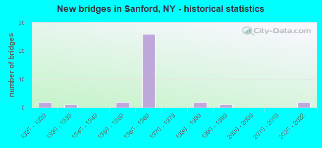
- New bridges - historical statistics
- 21920-1929
- 11930-1939
- 21950-1959
- 261960-1969
- 21980-1989
- 11990-1999
- 22020-2022
FCC Registered Cell Phone Towers:
1 (See the full list of FCC Registered Cell Phone Towers in Sanford)FCC Registered Antenna Towers:
16 (See the full list of FCC Registered Antenna Towers)FCC Registered Microwave Towers:
3- DEPOSIT, Oquaga Lake Road (Lat: 42.033472 Lon: -75.449806), Type: Mast, Structure height: 53 m, Overall height: 56.7 m, Call Sign: WQZW455,
Assigned Frequencies: 6137.92 MHz, 6137.92 MHz, 6137.92 MHz, 6137.92 MHz, 6137.92 MHz, 6137.92 MHz, 6137.92 MHz, 6137.92 MHz, 6078.62 MHz, 6137.92 MHz... (+10 more), Grant Date: 08/19/2017, Expiration Date: 08/19/2027, Certifier: Scott A Basista, Registrant: Transwave Communication Systems, Inc., 9020 Wehrie Dr, Buffalo, NY 14031, Phone: (716) 626-9020, Fax: (716) 626-4991, Email:
- SANFORD, Off Marsh Pond Road, Sanford, Ny (Lat: 42.116917 Lon: -75.508833), Type: Ltower, Structure height: 91.4 m, Call Sign: WRMP763,
Assigned Frequencies: 10915.0 MHz, 10995.0 MHz, Grant Date: 05/13/2021, Expiration Date: 05/13/2031, Certifier: Tom Vroman, Registrant: County Of Broome, 153 Lt. Vanwinkle Drive, Binghamton, NY 13905, Phone: (607) 778-8214, Email:
- LAUREL LAKE, 542 Laurel Lake Rd (Lat: 42.010056 Lon: -75.486417), Type: Mast, Structure height: 60.9 m, Call Sign: WRMP784,
Assigned Frequencies: 10835.0 MHz, 6078.62 MHz, Grant Date: 05/13/2021, Expiration Date: 05/13/2031, Certifier: Tom Vroman, Registrant: County Of Broome, 153 Lt. Vanwinkle Drive, Binghamton, NY 13905, Phone: (607) 778-8214, Email:
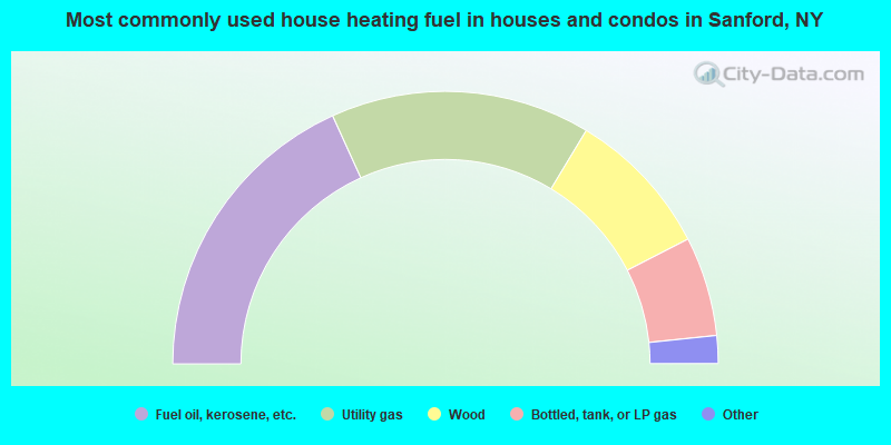
- 36.4%Fuel oil, kerosene, etc.
- 30.8%Utility gas
- 17.6%Wood
- 11.8%Bottled, tank, or LP gas
- 2.3%Electricity
- 1.0%Coal or coke
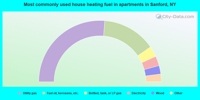
- 52.5%Utility gas
- 28.3%Fuel oil, kerosene, etc.
- 5.6%Bottled, tank, or LP gas
- 5.1%Electricity
- 4.5%Wood
- 3.0%No fuel used
- 1.0%Other fuel
Sanford compared to New York state average:
- Median house value significantly below state average.
- Unemployed percentage below state average.
- Black race population percentage significantly below state average.
- Hispanic race population percentage significantly below state average.
- Median age above state average.
- Foreign-born population percentage significantly below state average.
- Renting percentage significantly below state average.
- Length of stay since moving in significantly above state average.
- Number of rooms per house significantly below state average.
- House age significantly below state average.
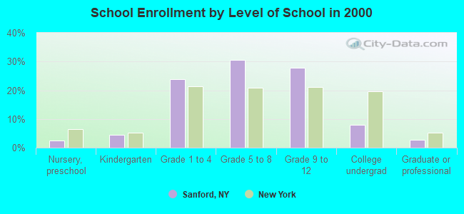
- Number of college students below state average.
- Percentage of population with a bachelor's degree or higher below state average.