Sacramento Canyon, California
Submit your own pictures of this place and show them to the world
- OSM Map
- General Map
- Google Map
- MSN Map

| Males: 887 | |
| Females: 874 |
| Median resident age: | 49.4 years |
| California median age: | 33.3 years |
Zip code: 96017
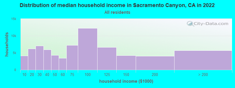
| Sacramento Canyon: | $68,356 |
| CA: | $91,551 |
Estimated per capita income in 2022: $38,196 (it was $19,199 in 2000)
Sacramento Canyon CCD income, earnings, and wages data
Estimated median house or condo value in 2022: $381,520 (it was $121,300 in 2000)
| Sacramento Canyon: | $381,520 |
| CA: | $715,900 |
Mean prices in 2022: all housing units: $370,501; detached houses: $409,007; townhouses or other attached units: $359,872; in 2-unit structures: $411,184; in 3-to-4-unit structures: $437,892; in 5-or-more-unit structures: $487,419; mobile homes: $134,922; occupied boats, rvs, vans, etc.: $31,319
Sacramento Canyon, CA residents, houses, and apartments details
Detailed information about poverty and poor residents in Sacramento Canyon, CA


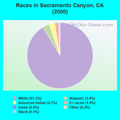
- 1,46991.3%White alone
- 553.4%Hispanic
- 442.7%American Indian alone
- 301.9%Two or more races
- 60.4%Asian alone
- 30.2%Other race alone
- 20.1%Black alone
 Recent articles from our blog. Our writers, many of them Ph.D. graduates or candidates, create easy-to-read articles on a wide variety of topics.
Current Local Time: PST time zone
Land area: 469.6 square miles.
Population density: 3.7 people per square mile (very low).

| Sacramento Canyon CCD: | 0.7% ($815) |
| California: | 0.8% ($1,564) |
Nearest city with pop. 50,000+: Redding, CA  (33.0 miles , pop. 80,865).
Nearest city with pop. 200,000+: Sacramento, CA (178.8 miles , pop. 407,018).
Nearest city with pop. 1,000,000+: Los Angeles, CA (528.5 miles , pop. 3,694,820).
Nearest cities:
), ), ), Latitude: 41.05 N, Longitude: 122.34 W
Area code commonly used in this area: 530

| Here: | 5.6% |
| California: | 5.1% |
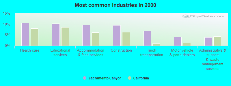
- Health care (10.6%)
- Educational services (10.2%)
- Accommodation & food services (9.6%)
- Construction (9.4%)
- Truck transportation (6.8%)
- Motor vehicle & parts dealers (4.1%)
- Administrative & support & waste management services (3.8%)
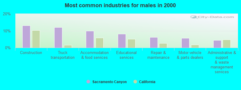
- Construction (13.0%)
- Truck transportation (12.0%)
- Accommodation & food services (9.9%)
- Educational services (8.1%)
- Repair & maintenance (6.2%)
- Motor vehicle & parts dealers (5.7%)
- Administrative & support & waste management services (4.4%)
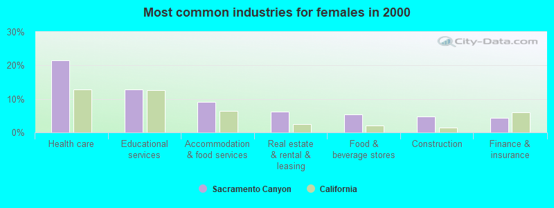
- Health care (21.4%)
- Educational services (12.9%)
- Accommodation & food services (9.2%)
- Real estate & rental & leasing (6.1%)
- Food & beverage stores (5.4%)
- Construction (4.8%)
- Finance & insurance (4.4%)
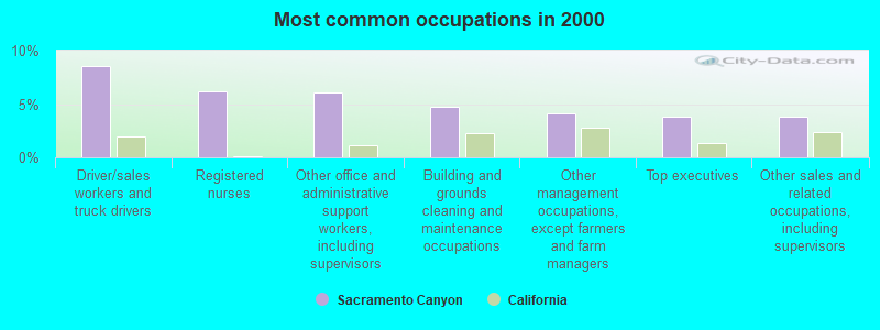
- Driver/sales workers and truck drivers (8.6%)
- Registered nurses (6.2%)
- Other office and administrative support workers, including supervisors (6.0%)
- Building and grounds cleaning and maintenance occupations (4.7%)
- Other management occupations, except farmers and farm managers (4.1%)
- Top executives (3.8%)
- Other sales and related occupations, including supervisors (3.8%)
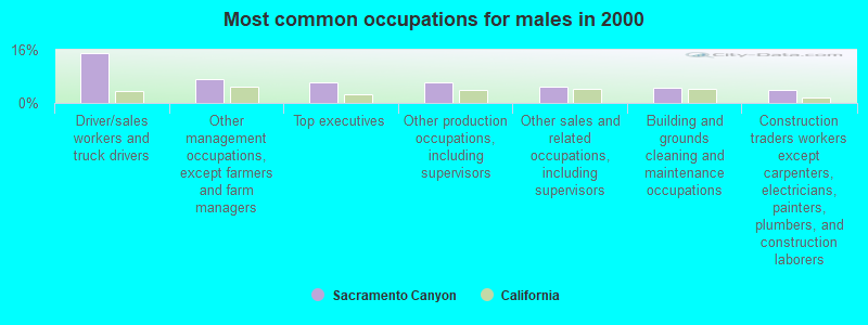
- Driver/sales workers and truck drivers (15.1%)
- Other management occupations, except farmers and farm managers (7.3%)
- Top executives (6.2%)
- Other production occupations, including supervisors (6.2%)
- Other sales and related occupations, including supervisors (4.9%)
- Building and grounds cleaning and maintenance occupations (4.7%)
- Construction traders workers except carpenters, electricians, painters, plumbers, and construction laborers (3.9%)
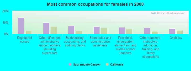
- Registered nurses (14.3%)
- Other office and administrative support workers, including supervisors (9.9%)
- Bookkeeping, accounting, and auditing clerks (7.1%)
- Secretaries and administrative assistants (6.5%)
- Preschool, kindergarten, elementary, and middle school teachers (5.8%)
- Other teachers, instructors, education, training, and library occupations (5.4%)
- Cashiers (4.8%)
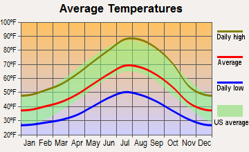
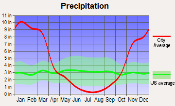
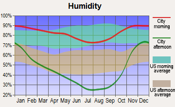
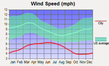
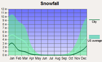
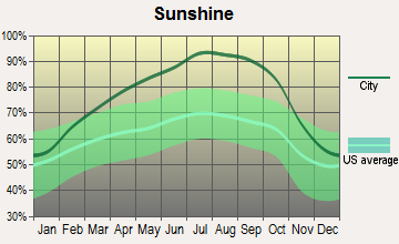
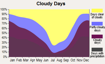
Average climate in Sacramento Canyon, California
Based on data reported by over 4,000 weather stations
Earthquake activity:
Sacramento Canyon-area historical earthquake activity is significantly above California state average. It is 4651% greater than the overall U.S. average.On 4/18/1906 at 13:12:21, a magnitude 7.9 (7.9 UK, Class: Major, Intensity: VIII - XII) earthquake occurred 214.1 miles away from Sacramento Canyon center, causing $524,000,000 total damage
On 1/31/1922 at 13:17:28, a magnitude 7.6 (7.6 UK) earthquake occurred 169.9 miles away from Sacramento Canyon center
On 11/8/1980 at 10:27:34, a magnitude 7.2 (6.2 MB, 7.2 MS, 7.2 MW, 7.0 ML) earthquake occurred 102.4 miles away from Sacramento Canyon center
On 4/25/1992 at 18:06:04, a magnitude 7.2 (6.3 MB, 7.1 MS, 7.2 MW, 7.1 MW, Depth: 9.4 mi) earthquake occurred 102.9 miles away from the city center, causing $75,000,000 total damage
On 1/22/1923 at 09:04:18, a magnitude 7.2 (7.2 UK) earthquake occurred 161.2 miles away from the city center
On 10/3/1915 at 06:52:48, a magnitude 7.6 (7.6 UK) earthquake occurred 256.2 miles away from the city center
Magnitude types: body-wave magnitude (MB), local magnitude (ML), surface-wave magnitude (MS), moment magnitude (MW)
Natural disasters:
The number of natural disasters in Shasta County (29) is a lot greater than the US average (15).Major Disasters (Presidential) Declared: 13
Emergencies Declared: 4
Causes of natural disasters: Floods: 14, Fires: 12, Storms: 8, Winter Storms: 6, Landslides: 5, Mudslides: 4, Drought: 1, Heavy Rain: 1, Hurricane: 1, Tornado: 1, Wind: 1, Other: 1 (Note: some incidents may be assigned to more than one category).
Colleges/universities with over 2000 students nearest to Sacramento Canyon:
- Shasta College (about 30 miles; Redding, CA; Full-time enrollment: 5,645)
- Southern Oregon University (about 81 miles; Ashland, OR; FT enrollment: 4,650)
- Oregon Institute of Technology (about 89 miles; Klamath Falls, OR; FT enrollment: 2,900)
- Humboldt State University (about 92 miles; Arcata, CA; FT enrollment: 7,353)
- California State University-Chico (about 96 miles; Chico, CA; FT enrollment: 14,838)
- College of the Redwoods (about 101 miles; Eureka, CA; FT enrollment: 4,410)
- Butte College (about 104 miles; Oroville, CA; FT enrollment: 8,649)
Points of interest:
Notable locations in Sacramento Canyon: Sugar Pine Sheep Camp (A), Tollhouse (B), Schultz Sheep Camp (C), Wintoon Campground (D), Willow Creek Ranch (E), Upper Salt Creek Resort (F), Sims Lookout (G), Girard Lookout (H), Stuckeys Place (I), Dekkas Rock Campground (J), Pollard Flat Campground (K), Gregory Beach Campground (L), Lakeshore Resort (M), Lakeshore East Campground (N), Ellery Creek Campground (O), Lakeshore East Campground (P), Moore Creek Campground (Q), Jennings Creek Camp (R), Beehive Campground (S), Tasadi Resort (T). Display/hide their locations on the map
Lakes: Grey Rock Lake (A), Lake Helen (B), Echo Lake (C). Display/hide their locations on the map
Rivers and creeks: Brush Creek (A), Dutch Creek (B), Flume Creek (C), Hazel Creek (D), Ladybug Creek (E), Mears Creek (F), Lost Creek (G), Pit River (H), Tom Head Creek (I). Display/hide their locations on the map
Parks in Sacramento Canyon include: Salt Creek Picnic Area (1), Castle Crags State Park (2). Display/hide their locations on the map
| This place: | 2.0 people |
| California: | 2.9 people |
| This place: | 57.9% |
| Whole state: | 68.7% |
| This place: | 7.2% |
| Whole state: | 7.2% |
Likely homosexual households (counted as self-reported same-sex unmarried-partner households)
- Lesbian couples: 0.6% of all households
- Gay men: 1.2% of all households
| This place: | 13.7% |
| Whole state: | 14.2% |
| This place: | 4.9% |
| Whole state: | 6.3% |
For population 15 years and over in Sacramento Canyon:
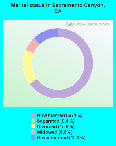
- Never married: 12.3%
- Now married: 65.1%
- Separated: 0.4%
- Widowed: 6.6%
- Divorced: 15.9%
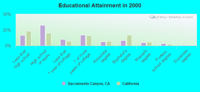
For population 25 years and over in Sacramento Canyon:
- High school or higher: 83.5%
- Bachelor's degree or higher: 17.4%
- Graduate or professional degree: 9.2%
- Unemployed: 8.7%
- Mean travel time to work (commute): 26.8 minutes
| Here: | 10.4 |
| California average: | 16.1 |
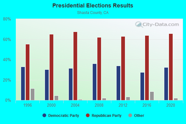
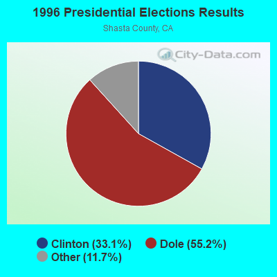
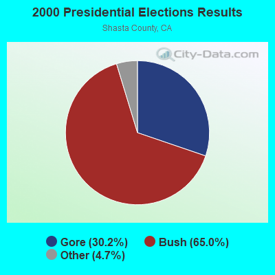
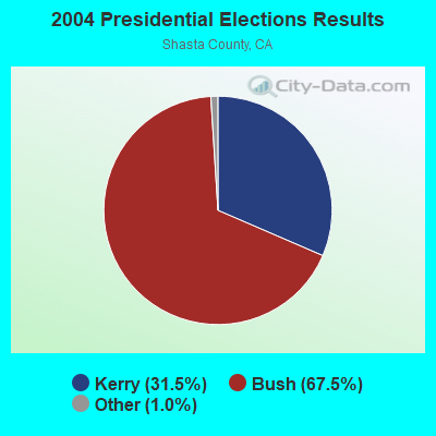
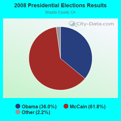
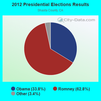
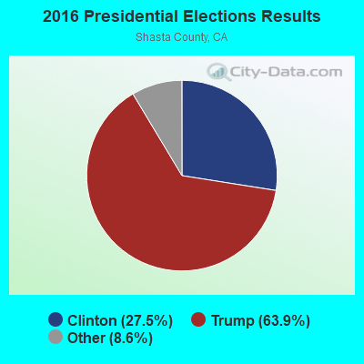

Graphs represent county-level data. Detailed 2008 Election Results
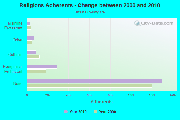
Religion statistics for Sacramento Canyon, CA (based on Shasta County data)
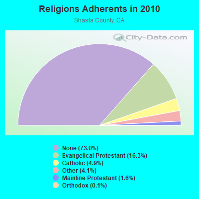
| Religion | Adherents | Congregations |
|---|---|---|
| Evangelical Protestant | 28,805 | 109 |
| Catholic | 8,629 | 8 |
| Other | 7,277 | 29 |
| Mainline Protestant | 2,830 | 12 |
| Orthodox | 191 | 5 |
| Black Protestant | 120 | 1 |
| None | 129,371 | - |
Food Environment Statistics:
| This county: | 2.35 / 10,000 pop. |
| California: | 2.14 / 10,000 pop. |
| Here: | 0.06 / 10,000 pop. |
| California: | 0.04 / 10,000 pop. |
| Here: | 0.39 / 10,000 pop. |
| California: | 0.62 / 10,000 pop. |
| Here: | 3.85 / 10,000 pop. |
| California: | 1.49 / 10,000 pop. |
| This county: | 6.42 / 10,000 pop. |
| State: | 7.42 / 10,000 pop. |
| Shasta County: | 8.0% |
| California: | 7.3% |
| This county: | 25.3% |
| California: | 21.3% |
| Shasta County: | 15.4% |
| California: | 17.9% |
Strongest AM radio stations in Sacramento Canyon:
- KNRO (1670 AM; 10 kW; REDDING, CA; Owner: REGENT LICENSEE OF REDDING, INC.)
- KVIP (540 AM; 2 kW; REDDING, CA; Owner: PACIFIC CASCADE COMMUNICATIONS CORP.)
- KMJC (620 AM; 1 kW; MOUNT SHASTA, CA; Owner: JPR FOUNDATION INC.)
- KTMT (580 AM; 10 kW; ASHLAND, OR; Owner: MAPLETON COMMUNICATIONS, LLC)
- KKOH (780 AM; 50 kW; RENO, NV; Owner: CITADEL BROADCASTING COMPANY)
- KAPL (1300 AM; 20 kW; PHOENIX, OR; Owner: APPLEGATE MEDIA, INC.)
- KCBS (740 AM; 50 kW; SAN FRANCISCO, CA; Owner: INFINITY BROADCASTING OPERATIONS, INC.)
- KGRV (700 AM; 25 kW; WINSTON, OR; Owner: PACIFIC CASCADE COMMUNICATIONS CORP.)
- KFBK (1530 AM; 50 kW; SACRAMENTO, CA; Owner: AMFM RADIO LICENSES, L.L.C.)
- KFIA (710 AM; 25 kW; CARMICHAEL, CA; Owner: VISTA BROADCASTING INC.)
- KNBR (680 AM; 50 kW; SAN FRANCISCO, CA; Owner: KNBR LICO, INC.)
- KHTK (1140 AM; 50 kW; SACRAMENTO, CA; Owner: INFINITY RADIO SUBSIDIARY OPERATIONS INC.)
- KDUN (1030 AM; 50 kW; REEDSPORT, OR; Owner: PAMPLIN BROADCASTING-OREGON, INC.)
Strongest FM radio stations in Sacramento Canyon:
- KNSQ (88.1 FM; MOUNT SHASTA, CA; Owner: STATE OF ORE./STATE BD. OF HGR. ED.)
- KNTK (102.3 FM; WEED, CA; Owner: FOUR RIVERS BROADCASTING, INC.)
- KHRD (103.1 FM; WEAVERVILLE, CA; Owner: RESULTS RADIO LICENSEE, LLC)
- KNCQ (97.3 FM; REDDING, CA; Owner: RESULTS RADIO OF REDDING, LLC)
- KMJC-FM (107.9 FM; MT. SHASTA, CA; Owner: EDUCATIONAL MEDIA FOUNDATION)
- KNCA (89.7 FM; BURNEY, CA; Owner: OREGON STATE BOARD OF HIGHER ED.)
- K225AJ (92.9 FM; BURNEY/REDDING, CA; Owner: CALVARY CHAPEL OF TWIN FALLS, INC.)
- KRRX (106.1 FM; BURNEY, CA; Owner: REGENT LICENSEE OF REDDING, INC.)
- KVIP-FM (98.1 FM; REDDING, CA; Owner: PACIFIC CASCADE COMMUNICATIONS CORP.)
- KEWB (94.7 FM; ANDERSON, CA; Owner: RESULTS RADIO OF REDDING, LLC)
- KSHA (104.3 FM; REDDING, CA; Owner: REGENT LICENSEE OF REDDING, INC)
- K235AG (94.9 FM; DORRIS, CA; Owner: CALVARY CHAPEL OF TWIN FALLS, INC.)
- K207BU (89.3 FM; YREKA, CA; Owner: SOUTHERN OREGON UNIVERSITY)
- KNYR (91.3 FM; YREKA, CA; Owner: STATE OF OREGON/STATE BD/OREGON STAT)
- KSYC-FM (103.9 FM; YREKA, CA; Owner: FOUR RIVERS BROACASTING, INC.)
- K214BS (90.7 FM; YREKA, CA; Owner: THE UNIVERSITY FOUNDATION)
- K268AJ (101.5 FM; REDDING, CA; Owner: FAMILY STATIONS, INC.)
- K227AE (93.3 FM; REDDING, CA; Owner: RESULTS RADIO OF REDDING, LLC)
- K220EB (91.9 FM; BURNEY, CA; Owner: THE UNIVERSITY FOUNDATION)
- KESR (107.1 FM; SHASTA LAKE CITY, CA; Owner: RESULTS RADIO OF REDDING, LLC)
TV broadcast stations around Sacramento Canyon:
- K13FC (Channel 13; CASTELLA, CA; Owner: CATAMOUNT BROADCASTING OF CHICO-REDDING, INC.)
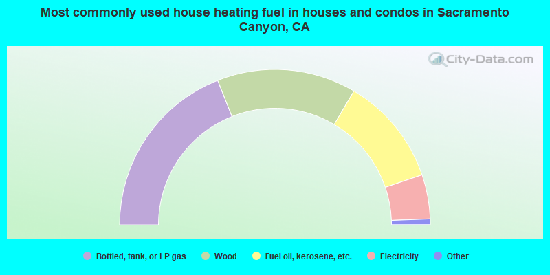
- 38.0%Bottled, tank, or LP gas
- 29.0%Wood
- 22.6%Fuel oil, kerosene, etc.
- 9.2%Electricity
- 0.9%Other fuel
- 0.3%Utility gas
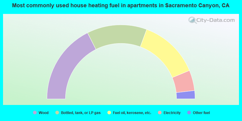
- 35.1%Wood
- 26.2%Bottled, tank, or LP gas
- 26.2%Fuel oil, kerosene, etc.
- 8.9%Electricity
- 3.6%Other fuel
Sacramento Canyon compared to California state average:
- Median house value below state average.
- Unemployed percentage below state average.
- Black race population percentage significantly below state average.
- Hispanic race population percentage significantly below state average.
- Median age significantly above state average.
- Foreign-born population percentage significantly below state average.
- Renting percentage significantly below state average.
- Length of stay since moving in significantly above state average.
- Number of rooms per house significantly below state average.
- House age significantly below state average.
- Number of college students below state average.