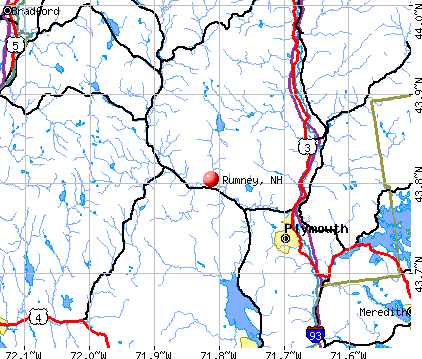
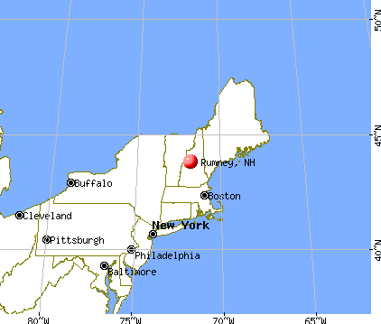
Rumney, New Hampshire
Submit your own pictures of this town and show them to the world
- OSM Map
- General Map
- Google Map
- MSN Map
Population change since 2000: 0.0%
 |
| Males: 762 | |
| Females: 718 |
| Median resident age: | 45.9 years |
| New Hampshire median age: | 43.9 years |
Zip codes: 03266.
| Rumney: | $74,543 |
| NH: | $89,992 |
Estimated per capita income in 2022: $39,042 (it was $17,169 in 2000)
Rumney town income, earnings, and wages data
Estimated median house or condo value in 2022: $298,208 (it was $93,300 in 2000)
| Rumney: | $298,208 |
| NH: | $384,700 |
Mean prices in 2022: all housing units: $486,096; detached houses: $533,852; townhouses or other attached units: $375,744; in 2-unit structures: $230,260; in 3-to-4-unit structures: $242,363; in 5-or-more-unit structures: $588,257; mobile homes: $127,035
Detailed information about poverty and poor residents in Rumney, NH
Compare current foreclosures near Rumney, NH:
| Photo | Address | Area | Beds / Baths | Price | Details |
|---|---|---|---|---|---|

|
#1
Streeter Woods Rd
Rumney, NH 03266
|
- sq. feet
|
- baths - beds |
show details | |

|
#2
Route 25a
Orford, NH 03777
|
2,222 sq. feet
|
2 baths 3 beds |
$564,900
|
show details |

|
#3
Prospect Hill Rd
Canaan, NH 03741
|
1,428 sq. feet
|
1 baths 4 beds |
show details | |

|
#4
New Hebron Rd
Plymouth, NH 03264
|
- sq. feet
|
- baths - beds |
show details | |

|
#5
Nh Route 118
Warren, NH 03279
|
- sq. feet
|
- baths - beds |
show details | |

|
#6
Summit Dr
Campton, NH 03223
|
- sq. feet
|
- baths - beds |
show details | |

|
#7
Beaver Path
Thornton, NH 03285
|
- sq. feet
|
- baths - beds |
show details | |

|
#8
N Main St
Bristol, NH 03222
|
- sq. feet
|
- baths - beds |
show details | |

|
#9
Lake St Apt 1
Bristol, NH 03222
|
- sq. feet
|
- baths - beds |
show details | |

|
#10
Mayhew Tpke
Plymouth, NH 03264
|
- sq. feet
|
- baths - beds |
show details |
| Photo | Address | Area | Beds / Baths | Price | Details |
|---|---|---|---|---|---|

|
#11
Fairgrounds Rd
Plymouth, NH 03264
|
- sq. feet
|
- baths - beds |
show details | |

|
#12
Eastside Rd
North Woodstock, NH 03262
|
- sq. feet
|
- baths - beds |
show details | |

|
Check over 1 million property listings on Foreclosure.com!
|
browse all offers | |||

- 1,41795.7%White alone
- 322.2%Two or more races
- 161.1%Hispanic
- 80.5%Asian alone
- 40.3%American Indian alone
- 20.1%Black alone
- 10.07%Other race alone

Races in Rumney detailed stats: ancestries, foreign born residents, place of birth
Full-time law enforcement employees in 2021, including police officers: 1 (1 officers - 1 male; 0 female).
| Officers per 1,000 residents here: | 0.63 |
| New Hampshire average: | 2.14 |
 Recent articles from our blog. Our writers, many of them Ph.D. graduates or candidates, create easy-to-read articles on a wide variety of topics.

 | Looking for Brad, Rumney NH (2 replies) |
| Move to NH - Suggested Areas & Towns? (108 replies) |
| What's it like to live in or near Plymouth? (6 replies) |
| Nice towns in NH (38 replies) |
| Looking for Off-Grid/Homestead Communities in New Hampshire (13 replies) |
| Moving to Berlin, is it that scary? (100 replies) |
Latest news from Rumney, NH collected exclusively by city-data.com from local newspapers, TV, and radio stations
Ancestries: English (28.6%), French (20.1%), Irish (16.2%), German (10.6%), Italian (6.0%), United States (5.1%).
Current Local Time: EST time zone
Incorporated in 1761
Elevation: 535 feet
Land area: 41.9 square miles.
Population density: 35 people per square mile (very low).
31 residents are foreign born (1.3% Europe, 0.4% North America, 0.3% Asia).
| This town: | 2.1% |
| New Hampshire: | 4.4% |
| Rumney town: | 2.0% ($1,880) |
| New Hampshire: | 2.3% ($2,946) |
Nearest city with pop. 50,000+: Manchester, NH  (59.5 miles , pop. 107,006).
Nearest city with pop. 200,000+: Boston, MA (109.0 miles , pop. 589,141).
Nearest city with pop. 1,000,000+: Bronx, NY (229.5 miles , pop. 1,332,650).
Nearest cities:
), ), Latitude: 43.80 N, Longitude: 71.83 W
Area code: 603


| Here: | 2.5% |
| New Hampshire: | 2.5% |


- Educational services (11.9%)
- Accommodation & food services (11.2%)
- Construction (10.9%)
- Health care (7.4%)
- Wood products (6.6%)
- Agriculture, forestry, fishing & hunting (3.2%)
- Repair & maintenance (2.9%)

- Construction (17.5%)
- Wood products (10.1%)
- Accommodation & food services (9.7%)
- Educational services (6.6%)
- Agriculture, forestry, fishing & hunting (5.4%)
- Health care (5.0%)
- Repair & maintenance (3.8%)

- Educational services (19.3%)
- Accommodation & food services (13.3%)
- Health care (11.0%)
- Religious, grantmaking, civic, professional, similar organizations (5.0%)
- Social assistance (5.0%)
- Food & beverage stores (4.0%)
- Finance & insurance (3.7%)

- Building and grounds cleaning and maintenance occupations (7.9%)
- Other production occupations, including supervisors (4.8%)
- Other sales and related occupations, including supervisors (3.9%)
- Laborers and material movers, hand (3.6%)
- Metal workers and plastic workers (3.6%)
- Carpenters (3.6%)
- Cooks and food preparation workers (3.3%)

- Building and grounds cleaning and maintenance occupations (9.0%)
- Carpenters (6.1%)
- Other sales and related occupations, including supervisors (5.7%)
- Laborers and material movers, hand (5.2%)
- Other production occupations, including supervisors (5.2%)
- Metal workers and plastic workers (4.7%)
- Electrical equipment mechanics and other installation, maintenance, and repair workers, including supervisors (4.5%)

- Waiters and waitresses (7.3%)
- Bookkeeping, accounting, and auditing clerks (6.6%)
- Building and grounds cleaning and maintenance occupations (6.3%)
- Preschool, kindergarten, elementary, and middle school teachers (5.0%)
- Child care workers (4.3%)
- Information and record clerks, except customer service representatives (4.3%)
- Other production occupations, including supervisors (4.3%)
Average climate in Rumney, New Hampshire
Based on data reported by over 4,000 weather stations


(lower is better)

Air Quality Index (AQI) level in 2022 was 46.9. This is significantly better than average.
| City: | 46.9 |
| U.S.: | 72.6 |

Ozone [ppb] level in 2022 was 29.7. This is about average. Closest monitor was 4.1 miles away from the city center.
| City: | 29.7 |
| U.S.: | 33.3 |

Particulate Matter (PM2.5) [µg/m3] level in 2022 was 4.52. This is significantly better than average. Closest monitor was 7.8 miles away from the city center.
| City: | 4.52 |
| U.S.: | 8.11 |
Tornado activity:
Rumney-area historical tornado activity is below New Hampshire state average. It is 70% smaller than the overall U.S. average.
On 5/11/1973, a category F2 (max. wind speeds 113-157 mph) tornado 17.1 miles away from the Rumney town center .
On 8/11/1966, a category F2 tornado 19.2 miles away from the town center caused between $50,000 and $500,000 in damages.
Earthquake activity:
Rumney-area historical earthquake activity is significantly above New Hampshire state average. It is 71% smaller than the overall U.S. average.On 4/20/2002 at 10:50:47, a magnitude 5.3 (5.3 ML, Depth: 3.0 mi, Class: Moderate, Intensity: VI - VII) earthquake occurred 104.9 miles away from Rumney center
On 10/7/1983 at 10:18:46, a magnitude 5.3 (5.1 MB, 5.3 LG, 5.1 ML) earthquake occurred 125.7 miles away from Rumney center
On 4/20/2002 at 10:50:47, a magnitude 5.2 (5.2 MB, 4.2 MS, 5.2 MW, 5.0 MW) earthquake occurred 105.0 miles away from Rumney center
On 1/19/1982 at 00:14:42, a magnitude 4.7 (4.5 MB, 4.7 MD, 4.5 LG, Class: Light, Intensity: IV - V) earthquake occurred 23.8 miles away from the city center
On 10/16/2012 at 23:12:25, a magnitude 4.7 (4.7 ML, Depth: 10.0 mi) earthquake occurred 60.4 miles away from the city center
On 6/16/1995 at 12:13:11, a magnitude 3.8 (3.8 LG, Depth: 3.1 mi, Class: Light, Intensity: II - III) earthquake occurred 33.8 miles away from the city center
Magnitude types: regional Lg-wave magnitude (LG), body-wave magnitude (MB), duration magnitude (MD), local magnitude (ML), surface-wave magnitude (MS), moment magnitude (MW)
Natural disasters:
The number of natural disasters in Grafton County (32) is a lot greater than the US average (15).Major Disasters (Presidential) Declared: 20
Emergencies Declared: 9
Causes of natural disasters: Floods: 16, Storms: 16, Hurricanes: 3, Snows: 3, Winter Storms: 3, Tropical Storms: 2, Blizzard: 1, Heavy Rain: 1, Ice Storm: 1, Landslide: 1, Snowfall: 1, Snowstorm: 1, Wind: 1, Other: 1 (Note: some incidents may be assigned to more than one category).
Colleges/universities with over 2000 students nearest to Rumney:
- Plymouth State University (about 8 miles; Plymouth, NH; Full-time enrollment: 4,838)
- Dartmouth College (about 24 miles; Hanover, NH; FT enrollment: 6,030)
- NHTI-Concord's Community College (about 43 miles; Concord, NH; FT enrollment: 2,865)
- Norwich University (about 48 miles; Northfield, VT; FT enrollment: 4,221)
- Southern New Hampshire University (about 56 miles; Manchester, NH; FT enrollment: 16,552)
- Saint Anselm College (about 59 miles; Manchester, NH; FT enrollment: 2,059)
- Mount Washington College (about 61 miles; Manchester, NH; FT enrollment: 2,187)
Public elementary/middle school in Rumney:
- RUSSELL ELEMENTARY SCHOOL (Students: 155, Location: 195 SCHOOL ST., Grades: KG-8)
Private elementary/middle school in Rumney:
- THE HUNTER SCHOOL (Students: 21, Location: 768 DOETOWN RD, Grades: 3-8)
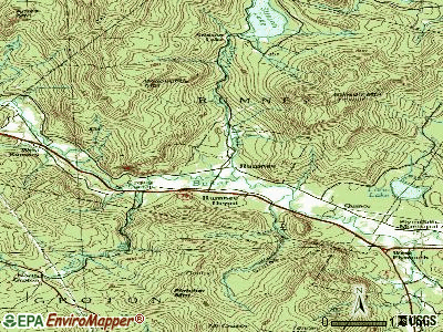
Points of interest:
Notable locations in Rumney: Camp Eagle Cliff (A), Camp Raleigh (B), Plymouth Sands Camping Area (C), Rumney Emergency Medical Services (D), Rumney Fire Department (E). Display/hide their locations on the map
Church in Rumney: Rumney Baptist Church (A). Display/hide its location on the map
Cemetery: Pleasant View Cemetery (1). Display/hide its location on the map
Reservoir: Stinson Lake (A). Display/hide its location on the map
Streams, rivers, and creeks: Halls Brook (A), Red Brook (B), Stinson Brook (C), Sucker Brook (D). Display/hide their locations on the map
Birthplace of: Nathan Clifford - Politician.
Drinking water stations with addresses in Rumney and their reported violations in the past:
RUMNEY BIBLE CONFERENCE CENTER (Population served: 300, Groundwater):Past health violations:RIVERBROOK RV RESORT (Population served: 225, Groundwater):Past monitoring violations:
- MCL, Monthly (TCR) - Between JUL-2009 and SEP-2009, Contaminant: Coliform. Follow-up actions: St Public Notif requested (JUN-30-2009), St Violation/Reminder Notice (JUN-30-2009), St Formal NOV issued (JUL-07-2009), St Public Notif received (SEP-04-2009), St Compliance achieved (MAY-25-2010)
- MCL, Monthly (TCR) - Between APR-2009 and JUN-2009, Contaminant: Coliform. Follow-up actions: St Public Notif requested (JUN-18-2009), St Violation/Reminder Notice (JUN-18-2009), St Public Notif received (JUN-25-2009), St Formal NOV issued (JUL-07-2009), St Compliance achieved (MAY-25-2010)
- One routine major monitoring violation
Past health violations:WHITE MOUNTAIN RANCH (Population served: 180, Groundwater):Past monitoring violations:
- MCL, Monthly (TCR) - Between JUL-2009 and SEP-2009, Contaminant: Coliform. Follow-up actions: St Violation/Reminder Notice (AUG-13-2009), St Public Notif requested (AUG-13-2009), St Public Notif received (AUG-24-2009), St Compliance achieved (SEP-29-2010)
- Monitoring, Source Water (GWR) - Between AUG-22-2012 and SEP-22-2012, Contaminant: E. COLI. Follow-up actions: St Public Notif requested (OCT-04-2012), St Violation/Reminder Notice (OCT-04-2012), St Public Notif received (DEC-07-2012), St Compliance achieved (MAY-14-2013)
- Monitoring, Repeat Major (TCR) - Between JUL-2012 and SEP-2012, Contaminant: Coliform (TCR). Follow-up actions: St Public Notif received (SEP-18-2012), St Public Notif requested (OCT-04-2012), St Compliance achieved (OCT-04-2012), St Violation/Reminder Notice (OCT-04-2012)
- 2 routine major monitoring violations
- 2 regular monitoring violations
Past monitoring violations:
- One routine major monitoring violation
| This town: | 2.5 people |
| New Hampshire: | 2.5 people |
| This town: | 69.5% |
| Whole state: | 66.3% |
| This town: | 6.6% |
| Whole state: | 8.3% |
Likely homosexual households (counted as self-reported same-sex unmarried-partner households)
- Lesbian couples: 0.2% of all households
- Gay men: 0.0% of all households
| This town: | 9.5% |
| Whole state: | 6.5% |
| This town: | 3.5% |
| Whole state: | 2.8% |
15 people in homes for abused, dependent, and neglected children in 2000
13 people in nursing homes in 2000
For population 15 years and over in Rumney:

- Never married: 23.9%
- Now married: 57.1%
- Separated: 1.3%
- Widowed: 7.1%
- Divorced: 10.6%
For population 25 years and over in Rumney:
- High school or higher: 82.3%
- Bachelor's degree or higher: 26.1%
- Graduate or professional degree: 10.1%
- Unemployed: 3.8%
- Mean travel time to work (commute): 23.2 minutes


| Here: | 11.3 |
| New Hampshire average: | 10.9 |


Graphs represent county-level data. Detailed 2008 Election Results
Religion statistics for Rumney, NH (based on Grafton County data)


| Religion | Adherents | Congregations |
|---|---|---|
| Catholic | 9,503 | 12 |
| Mainline Protestant | 7,832 | 57 |
| Evangelical Protestant | 1,494 | 29 |
| Other | 1,320 | 11 |
| None | 68,969 | - |
Food Environment Statistics:
| Grafton County: | 3.87 / 10,000 pop. |
| State: | 2.14 / 10,000 pop. |
| Grafton County: | 0.23 / 10,000 pop. |
| State: | 0.15 / 10,000 pop. |
| This county: | 1.29 / 10,000 pop. |
| New Hampshire: | 1.78 / 10,000 pop. |
| This county: | 6.45 / 10,000 pop. |
| New Hampshire: | 4.02 / 10,000 pop. |
| This county: | 14.41 / 10,000 pop. |
| New Hampshire: | 9.70 / 10,000 pop. |
| Here: | 7.2% |
| New Hampshire: | 7.6% |
| Here: | 22.9% |
| State: | 24.4% |
| Grafton County: | 15.9% |
| New Hampshire: | 15.9% |
Strongest AM radio stations in Rumney:
- WPNH (1300 AM; 5 kW; PLYMOUTH, NH; Owner: NORTHEAST COMMUNICATIONS CORPORATION)
- WNTK (1020 AM; 10 kW; NEWPORT, NH; Owner: KOOR COMMUNICATIONS, INC.)
- WRKO (680 AM; 50 kW; BOSTON, MA; Owner: ENTERCOM BOSTON LICENSE, LLC)
- WTWN (1100 AM; daytime; 5 kW; WELLS RIVER, VT; Owner: PUFFER BROADCASTING, INC.)
- WEZS (1350 AM; 5 kW; LACONIA, NH; Owner: GARY W. HAMMOND)
- WCRN (830 AM; 50 kW; WORCESTER, MA; Owner: CARTER BROADCASTING CORPORATION)
- WNNZ (640 AM; 50 kW; WESTFIELD, MA; Owner: CLEAR CHANNEL BROADCASTING LICENSES, INC.)
- WEEI (850 AM; 50 kW; BOSTON, MA; Owner: ENTERCOM BOSTON LICENSE, LLC)
- WKOX (1200 AM; 50 kW; FRAMINGHAM, MA; Owner: CAPSTAR TX LIMITED PARTNERSHIP)
- WBZ (1030 AM; 50 kW; BOSTON, MA; Owner: INFINITY BROADCASTING OPERATIONS, INC.)
- WGY (810 AM; 50 kW; SCHENECTADY, NY; Owner: CLEAR CHANNEL BROADCASTING LICENSES, INC.)
- WCHP (760 AM; 35 kW; CHAMPLAIN, NY; Owner: CHAMPLAIN RADIO, INC.)
- WBIX (1060 AM; 40 kW; NATICK, MA; Owner: LANGER BROADCASTING CORPORATION)
Strongest FM radio stations in Rumney:
- WPNH-FM (100.1 FM; PLYMOUTH, NH; Owner: NORTHEAST COMMUNICATIONS CORPORATION)
- WVFM (105.7 FM; CAMPTON, NH; Owner: DEVON BROADCASTING COMPANY, INC.)
- WSCY (106.9 FM; MOULTONBOROUGH, NH; Owner: NORTHEAST COMMUNICATIONS CORPORATION)
- WEVH (91.3 FM; HANOVER, NH; Owner: NEW HAMPSHIRE PUBLIC RADIO INC)
- WPKQ (103.7 FM; NORTH CONWAY, NH; Owner: CITADEL BROADCASTING COMPANY)
- WHOM (94.9 FM; MT. WASHINGTON, NH; Owner: CITADEL BROADCASTING COMPANY)
- WHDQ (106.1 FM; CLAREMONT, NH; Owner: GREAT NORTHERN RADIO, L.L.C.)
- WVPR (89.5 FM; WINDSOR, VT; Owner: VERMONT PUBLIC RADIO)
- WJJR (98.1 FM; RUTLAND, VT; Owner: 6 JOHNSON ROAD LICENSES, INC.)
- WZRT (97.1 FM; RUTLAND, VT; Owner: CAPSTAR TX LIMITED PARTNERSHIP)
- WEBK (105.3 FM; KILLINGTON, VT; Owner: 6 JOHNSON ROAD LICENSES, INC.)
- WLKZ (104.9 FM; WOLFEBORO, NH; Owner: TELE-MEDIA COMPANY OF NEW HAMPSHIRE, L.L.C.)
- WGLV (91.7 FM; WOODSTOCK, VT; Owner: CHRISTIAN MINISTRIES INC)
- WHDQ-FM1 (106.1 FM; RUTLAND, VT; Owner: GREAT NORTHERN RADIO, L.L.C.)
- WGMT (97.7 FM; LYNDON, VT; Owner: VERMONT BROADCAST ASSOCIATES, INC.)
- WNHI (93.3 FM; BELMONT, NH; Owner: CONCORD BROADCASTING, L.L.C.)
- WCVT (101.7 FM; STOWE, VT; Owner: RADIO VERMONT CLASSICS, L.L.C.)
- WDEV-FM (96.1 FM; WARREN, VT; Owner: RADIO VERMONT, INC.)
- WMTK (106.3 FM; LITTLETON, NH; Owner: VERMONT BROADCAST ASSOCIATES, INC.)
- WVPS (107.9 FM; BURLINGTON, VT; Owner: VERMONT PUBLIC RADIO)
TV broadcast stations around Rumney:
- W15BK (Channel 15; HANOVER, NH; Owner: UNIVERSITY OF NEW HAMPSHIRE)
- WMTW-TV (Channel 8; POLAND SPRING, ME; Owner: WMTW BROADCAST GROUP, LLC)
- Rumney, New Hampshire
- Fatal accident count16
- Vehicles involved in fatal accidents22
- Fatal accidents involving drunk persons:9
- Fatalities18
- Persons involved in fatal accidents36
- Pedestrians involved in fatal accidents1
- New Hampshire average
- Fatal accident count1646
- Vehicles involved in fatal accidents2425
- Fatal accidents involving drunk persons650
- Fatalities1799
- Persons involved in fatal accidents3781
- Pedestrians involved in fatal accidents121
- National Bridge Inventory (NBI) Statistics
- 9Number of bridges
- 59ft / 18.4mTotal length
- $28,278,000Total costs
- 16,368Total average daily traffic
- 1,209Total average daily truck traffic
- 24,219Total future (year 2042) average daily traffic
FCC Registered Antenna Towers:
7- Michael J Umano, Off Quincy Road (Lat: 43.802028 Lon: -71.801083), Type: 106.6, Overall height: 100.5 m, Registrant: Kevin.Delaney@induscom.Com, Phone: (781) 319-1011
- Michael J Umano, Off Quincy Road (Lat: 43.802028 Lon: -71.801083), Type: 106.6, Structure height: 33009 m, Overall height: 100.5 m, Registrant: Kevin.Delaney@induscom.Com, Phone: (781) 319-1011
- Victor Drouin, 117 Prospect Hill Road (Lat: 43.824139 Lon: -71.885778), Type: 59.4, Structure height: 33009 m, Overall height: 57.9 m, Registrant: Gmr Holdings Of New Hampshire, LLC, Gmci2@greenmtncomm.Com, , Pembr-oke, Phone: (603) 717-7117
- Victor Drouin, 117 Prospect Hill Road (Lat: 43.824139 Lon: -71.885778), Type: 59.4, Structure height: 33009 m, Overall height: 57.9 m, Licensee ID: L, Registrant: Gmr Holdings Of New Hampshire, LLC, Delilah@greenmtncomm.Com, , Pembr-oke, Phone: (603) 717-7117
- Victor Drouin, 117 Prospect Hill Road (Lat: 43.824139 Lon: -71.885778), Type: 59.4, Structure height: 33009 m, Overall height: 57.9 m, Registrant: Gmr Holdings Of New Hampshire, LLC, Gmci2@greenmtncomm.Com, , Pembr-oke, Phone: (603) 717-7117
- Michael J Umano, 333 Quincy Road (Lat: 43.802028 Lon: -71.801083), Type: 106.6, Structure height: 33009 m, Overall height: 100.5 m, Registrant: Industrial Tower And Wireless, LLC, Kevin.Delaney@itwllc.Com, , Marsh-field, Phone: (781) 319-1011
- Michael J Umano, 333 Quincy Road (Lat: 43.802028 Lon: -71.801083), Type: 106.6, Structure height: 33009 m, Overall height: 100.5 m, Licensee ID: L, Registrant: Industrial Tower And Wireless, LLC, Kevin.Delaney@itwllc.Com, , Marsh-field, Phone: (781) 319-1111
FCC Registered Broadcast Land Mobile Towers:
4- Rt 118 At Rt 25 (Lat: 43.819528 Lon: -71.885639), Structure height: 17 m, Call Sign: WNWM471,
Assigned Frequencies: 47.9600 MHz, 48.4200 MHz, 48.4800 MHz, Grant Date: 08/25/2015, Expiration Date: 10/03/2025, Registrant: Utilties Telecom Council, 1129 20th Street Nw, Suite 350, Washington, DC 20036, Phone: (202) 872-0030, Fax: (202) 872-1331, Email:
- Lat: 43.788611 Lon: -71.793889, Call Sign: WQIX420,
Assigned Frequencies: 160.162 MHz, 160.027 MHz, 160.192 MHz, 159.952 MHz, Grant Date: 06/10/2008, Expiration Date: 06/10/2018, Cancellation Date: 08/11/2018, Certifier: Chris J Knudson, Registrant: Skylines Unlimited Inc, 100 Stone Church Road, Carlisle, PA 17015, Phone: (717) 218-5003, Fax: (717) 218-5005, Email:
- Lat: 43.796167 Lon: -71.809167, Call Sign: WQUH870,
Assigned Frequencies: 72.1000 MHz, Grant Date: 07/14/2014, Expiration Date: 07/14/2024, Certifier: Jon Francis, Registrant: Primex Wireless, Inc., 965 Wells Street, Lake Geneva, WI 53147, Phone: (800) 537-0464
- Lat: 43.783056 Lon: -71.787194, Call Sign: WQUJ938,
Assigned Frequencies: 159.607 MHz, 159.660 MHz, 159.600 MHz, 160.005 MHz, Grant Date: 07/29/2014, Expiration Date: 07/29/2024, Certifier: Robert Arey, Registrant: Communications Express, Inc, 5407 C Port Royal Road, Springfield, VA 22151, Phone: (703) 321-0470, Fax: (703) 321-0474, Email:
FCC Registered Amateur Radio Licenses:
25 (See the full list of FCC Registered Amateur Radio Licenses in Rumney)FAA Registered Aircraft:
5- Aircraft: BLUE HERON MARATHON (Category: Land, Seats: 2, Weight: Up to 12,499 Pounds), Engine: ROTAX 582SER (65 HP) (2 Cycle)
N-Number: 2628R, N2628R, N-2628R, Serial Number: HD00039M, Year manufactured: 2001, Airworthiness Date: 12/27/2007, Certificate Issue Date: 11/14/2017
Registrant (Individual): Laurianne M Olcott, 925 Quincy Rd, Rumney, NH 03266 - Aircraft: POWRACHUTE LLC AIRWOLF 912ULS (Category: Land, Seats: 2, Weight: Up to 12,499 Pounds), Engine: ROTAX 912ULS SERIES (100 HP) (4 Cycle)
N-Number: 855BF, N855BF, N-855BF, Serial Number: A314ULS, Year manufactured: 2018, Airworthiness Date: 09/05/2018, Certificate Issue Date: 10/19/2018
Registrant (LLC): Powered Parachute Instruction LLC, 72 Quincy Rd, Rumney, NH 03266 - Aircraft: POWRACHUTE LLC AIRWOLF 912ULS (Category: Land, Seats: 2, Weight: Up to 12,499 Pounds), Engine: 4 Cycle
N-Number: 879VP, N879VP, N-879VP, Serial Number: A335ULS, Certificate Issue Date: 02/10/2020
Registrant (LLC): Powered Parachute Instruction LLC, 72 Quincy Rd, Rumney, NH 03266 - Aircraft: POWRACHUTE LLC AIRWOLF 912ULS (Category: Land, Seats: 2, Weight: Up to 12,499 Pounds), Engine: ROTAX 912ULS SERIES (100 HP) (4 Cycle)
N-Number: 879WP, N879WP, N-879WP, Serial Number: A334ULS, Year manufactured: 2019, Airworthiness Date: 12/08/2019, Certificate Issue Date: 03/09/2020
Registrant (LLC): Powered Parachute Instruction LLC, 72 Quincy Rd, Rumney, NH 03266 - Aircraft: POWRACHUTE LLC AIRWOLF 912ULS (Category: Land, Seats: 2, Weight: Up to 12,499 Pounds), Engine: ROTAX 912ULS SERIES (100 HP) (4 Cycle)
N-Number: 879XP, N879XP, N-879XP, Serial Number: A336ULS, Year manufactured: 2019, Airworthiness Date: 12/08/2019, Certificate Issue Date: 02/10/2020
Registrant (LLC): Powered Parachute Instruction LLC, 72 Quincy Rd, Rumney, NH 03266
2002 - 2018 National Fire Incident Reporting System (NFIRS) incidents
- Fire incident types reported to NFIRS in Rumney, NH
- 9951.3%Structure Fires
- 6131.6%Outside Fires
- 2311.9%Other
- 105.2%Mobile Property/Vehicle Fires
 Based on the data from the years 2002 - 2018 the average number of fires per year is 11. The highest number of reported fires - 31 took place in 2015, and the least - 1 in 2003. The data has a growing trend.
 When looking into fire subcategories, the most incidents belonged to: Structure Fires (51.3%), and Outside Fires (31.6%).
- 71.8%Fuel oil, kerosene, etc.
- 19.5%Wood
- 7.9%Bottled, tank, or LP gas
- 0.4%Electricity
- 0.4%Coal or coke

- 61.3%Fuel oil, kerosene, etc.
- 21.8%Bottled, tank, or LP gas
- 13.4%Wood
- 3.4%Electricity
Rumney compared to New Hampshire state average:
- Unemployed percentage significantly below state average.
- Black race population percentage significantly below state average.
- Hispanic race population percentage significantly below state average.
- Foreign-born population percentage significantly below state average.
- Renting percentage below state average.
- Length of stay since moving in significantly above state average.
- Number of rooms per house significantly below state average.
- House age significantly below state average.
Rumney on our top lists:
- #28 on the list of "Top 101 cities with the largest percentage of people in homes for abused, dependent, and neglected children (population 1,000+)"
- #22 on the list of "Top 101 counties with highest percentage of residents voting for 3rd party candidates in the 2012 Presidential Election"
- #35 on the list of "Top 101 counties with the best general health status score of residents (1-5), 3 years of data"
- #50 on the list of "Top 101 counties with the highest percentage of residents that keep firearms around their homes"
- #67 on the list of "Top 101 counties with the highest percentage of residents that exercised in the past month"
- #67 on the list of "Top 101 counties with the lowest Particulate Matter (PM2.5) Annual air pollution readings in 2012 (µg/m3)"

|
Total of 2 patent applications in 2008-2024.