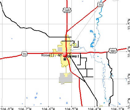
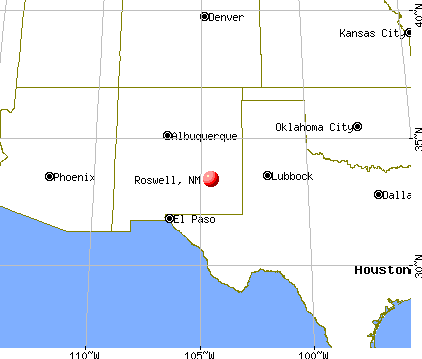
Roswell, New Mexico
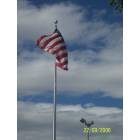
Roswell: Main Street - Looking South

Roswell: Scale quail love Roswell
Roswell: bird watchers dream town-quail
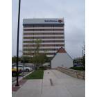
Roswell: Main Street - Facing North
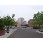
Roswell: Main Street - Facing West

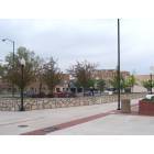
Roswell: Roswell New Mexico
Roswell: 20 minutesafter court halfer

Roswell: Roswell New Mexico
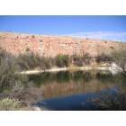
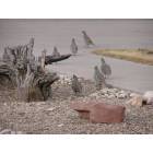
Roswell: Bottomless State Park
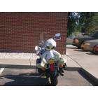
Roswell: Out of this world rider
Roswell: Roswell New Mexico
- see
29
more - add
your
Submit your own pictures of this city and show them to the world
- OSM Map
- General Map
- Google Map
- MSN Map
Population change since 2000: +4.6%
 |
| Males: 23,491 | |
| Females: 23,899 |
| Median resident age: | 36.2 years |
| New Mexico median age: | 39.4 years |
Zip codes: 88201.
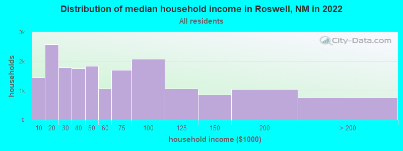
| Roswell: | $49,124 |
| NM: | $59,726 |
Estimated per capita income in 2022: $26,896 (it was $14,589 in 2000)
Roswell city income, earnings, and wages data
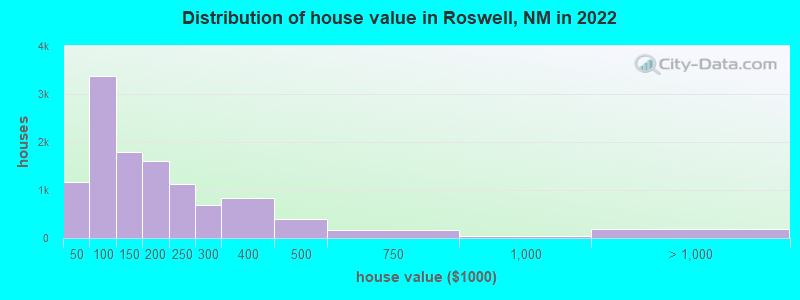
Estimated median house or condo value in 2022: $146,535 (it was $55,800 in 2000)
| Roswell: | $146,535 |
| NM: | $243,100 |
Median gross rent in 2022: $845.
(18.7% for White Non-Hispanic residents, 26.8% for Black residents, 26.4% for Hispanic or Latino residents, 15.0% for American Indian residents, 31.1% for other race residents, 25.4% for two or more races residents)
Detailed information about poverty and poor residents in Roswell, NM


Compare current foreclosures near Roswell, NM:
| Photo | Address | Area | Beds / Baths | Price | Details |
|---|---|---|---|---|---|

|
#1
Avenida Manana
Roswell, NM 88203
|
1,743 sq. feet
|
2 baths 4 beds |
show details | |

|
#2
Deborah Dr
Roswell, NM 88201
|
1,366 sq. feet
|
2 baths 3 beds |
show details | |

|
#3
S Fir Ave
Roswell, NM 88203
|
1,131 sq. feet
|
1 baths 3 beds |
show details | |

|
#4
Heather Dr
Roswell, NM 88203
|
- sq. feet
|
2 baths 3 beds |
show details | |

|
#5
N Michigan Ave
Roswell, NM 88201
|
852 sq. feet
|
1 baths 2 beds |
show details | |

|
#6
S Washington Ave
Roswell, NM 88203
|
2,032 sq. feet
|
2 baths - beds |
show details | |

|
#7
E Mescalero Rd
Roswell, NM 88201
|
1,896 sq. feet
|
2 baths 3 beds |
show details | |

|
#8
B St
Roswell, NM 88203
|
1,143 sq. feet
|
1 baths 3 beds |
show details | |

|
#9
Allen Ave
Roswell, NM 88201
|
1,753 sq. feet
|
2 baths 3 beds |
show details | |

|
#10
Andrews Pl
Roswell, NM 88203
|
1,376 sq. feet
|
1 baths 3 beds |
show details |
| Photo | Address | Area | Beds / Baths | Price | Details |
|---|---|---|---|---|---|

|
#11
W 10th St
Roswell, NM 88201
|
1,406 sq. feet
|
1 baths - beds |
show details | |

|
#12
S Michigan Ave
Roswell, NM 88203
|
2,111 sq. feet
|
3 baths - beds |
show details | |

|
#13
N Kansas Ave
Roswell, NM 88201
|
2,783 sq. feet
|
2 baths - beds |
show details | |

|
#14
E Church St
Roswell, NM 88203
|
1,218 sq. feet
|
1 baths - beds |
show details | |

|
#15
W Hervey Dr
Roswell, NM 88203
|
1,494 sq. feet
|
2 baths - beds |
show details | |

|
#16
N Garden Ave
Roswell, NM 88201
|
1,036 sq. feet
|
1 baths - beds |
show details | |

|
#17
Madison Ave
Roswell, NM 88203
|
1,286 sq. feet
|
1 baths - beds |
show details | |

|
#18
N Kansas Ave
Roswell, NM 88201
|
1,379 sq. feet
|
1 baths - beds |
show details | |

|
#19
W Tilden St
Roswell, NM 88203
|
1,102 sq. feet
|
1 baths - beds |
show details | |

|
#20
E Tilden St
Roswell, NM 88203
|
1,008 sq. feet
|
1 baths - beds |
show details |
| Photo | Address | Area | Beds / Baths | Price | Details |
|---|---|---|---|---|---|

|
#21
Pecan Dr
Roswell, NM 88201
|
1,204 sq. feet
|
1 baths - beds |
show details | |

|
#22
S Lea Ave
Roswell, NM 88203
|
2,140 sq. feet
|
2 baths - beds |
show details | |

|
#23
Alhambra Dr
Roswell, NM 88201
|
- sq. feet
|
- baths - beds |
show details | |

|
#24
N Kentucky Ave Apt B
Roswell, NM 88203
|
- sq. feet
|
- baths - beds |
show details | |

|
#25
N Sycamore Ave, Apt 209
Roswell, NM 88201
|
- sq. feet
|
- baths - beds |
show details | |

|
#26
Shoshoni Rd
Dexter, NM 88230
|
1,926 sq. feet
|
1 baths 3 beds |
show details | |

|
#27
Michelet Dr
Dexter, NM 88230
|
- sq. feet
|
- baths - beds |
show details | |

|
Check over 1 million property listings on Foreclosure.com!
|
browse all offers | |||


- 29,61361.6%Hispanic
- 15,84733.0%White alone
- 8061.7%Black alone
- 7021.5%Asian alone
- 7401.5%Two or more races
- 1910.4%American Indian alone
- 1690.4%Other race alone
- 190.04%Native Hawaiian and Other
Pacific Islander alone

Races in Roswell detailed stats: ancestries, foreign born residents, place of birth
According to our research of New Mexico and other state lists, there were 79 registered sex offenders living in Roswell, New Mexico as of May 23, 2024.
The ratio of all residents to sex offenders in Roswell is 612 to 1.
The ratio of registered sex offenders to all residents in this city is near the state average.
Type |
2009 |
2010 |
2011 |
2012 |
2013 |
2014 |
2015 |
2016 |
2017 |
2018 |
2019 |
2020 |
2021 |
2022 |
|---|---|---|---|---|---|---|---|---|---|---|---|---|---|---|
| Murders (per 100,000) | 7 (15.1) | 6 (12.4) | 5 (10.2) | 8 (16.5) | 10 (20.6) | 8 (16.4) | 8 (16.4) | 12 (24.7) | 5 (10.4) | 8 (16.8) | 9 (18.9) | 9 (19.0) | 9 (18.9) | 9 (18.9) |
| Rapes (per 100,000) | 17 (36.7) | 16 (33.1) | 15 (30.7) | 28 (57.6) | 38 (78.4) | 49 (100.7) | 39 (80.2) | 41 (84.4) | 42 (87.3) | 44 (92.3) | 61 (128.3) | 47 (99.0) | 29 (61.0) | 38 (79.8) |
| Robberies (per 100,000) | 43 (92.8) | 36 (74.4) | 36 (73.6) | 42 (86.4) | 34 (70.1) | 35 (72.0) | 38 (78.1) | 31 (63.8) | 19 (39.5) | 30 (62.9) | 36 (75.7) | 37 (78.0) | 39 (82.1) | 28 (58.8) |
| Assaults (per 100,000) | 330 (712.5) | 293 (605.8) | 244 (498.9) | 228 (468.9) | 229 (472.4) | 280 (575.7) | 233 (479.1) | 227 (467.5) | 240 (498.6) | 314 (658.6) | 298 (626.9) | 274 (577.4) | 389 (818.8) | 345 (724.4) |
| Burglaries (per 100,000) | 738 (1,593) | 541 (1,119) | 619 (1,266) | 552 (1,135) | 763 (1,574) | 642 (1,320) | 555 (1,141) | 363 (747.6) | 426 (885.0) | 398 (834.8) | 301 (633.2) | 234 (493.1) | 244 (513.6) | 223 (468.2) |
| Thefts (per 100,000) | 1,884 (4,068) | 1,714 (3,544) | 1,978 (4,044) | 1,988 (4,089) | 2,324 (4,795) | 2,278 (4,684) | 1,793 (3,687) | 1,666 (3,431) | 1,468 (3,050) | 1,456 (3,054) | 1,362 (2,865) | 1,007 (2,122) | 751 (1,581) | 1,036 (2,175) |
| Auto thefts (per 100,000) | 102 (220.2) | 70 (144.7) | 89 (182.0) | 75 (154.2) | 141 (290.9) | 137 (281.7) | 107 (220.0) | 103 (212.1) | 98 (203.6) | 154 (323.0) | 130 (273.5) | 142 (299.3) | 108 (227.3) | 162 (340.2) |
| Arson (per 100,000) | 18 (38.9) | 13 (26.9) | 21 (42.9) | 14 (28.8) | 31 (64.0) | 58 (119.3) | 22 (45.2) | 31 (63.8) | 22 (45.7) | 23 (48.2) | 27 (56.8) | 23 (48.5) | 29 (61.0) | 30 (63.0) |
| City-Data.com crime index | 521.8 | 426.4 | 431.8 | 454.0 | 544.7 | 552.5 | 461.3 | 436.2 | 402.4 | 464.4 | 469.5 | 399.4 | 392.5 | 411.1 |
The City-Data.com crime index weighs serious crimes and violent crimes more heavily. Higher means more crime, U.S. average is 246.1. It adjusts for the number of visitors and daily workers commuting into cities.
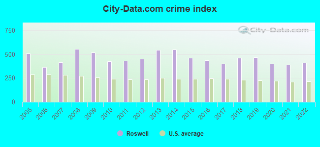
Crime rate in Roswell detailed stats: murders, rapes, robberies, assaults, burglaries, thefts, arson
Full-time law enforcement employees in 2021, including police officers: 101 (81 officers - 72 male; 9 female).
| Officers per 1,000 residents here: | 1.70 |
| New Mexico average: | 1.93 |
 Recent articles from our blog. Our writers, many of them Ph.D. graduates or candidates, create easy-to-read articles on a wide variety of topics.

 | Roswell......what's it like to live in? (17 replies) |
| Cell Service in Roswell (1 reply) |
| Roswell C.O.L. (8 replies) |
| Roswell, New Mexico (TV series) Jan 2019 (4 replies) |
| Albuquerque or Las Cruces??? (54 replies) |
| Roswell ICBM Sites Story (0 replies) |
Latest news from Roswell, NM collected exclusively by city-data.com from local newspapers, TV, and radio stations
Ancestries: American (10.2%), English (2.9%), German (2.2%), Irish (2.2%).
Current Local Time: MST time zone
Incorporated in 1903
Elevation: 3573 feet
Land area: 28.9 square miles.
Population density: 1,638 people per square mile (low).
5,537 residents are foreign born (9.5% Latin America, 1.2% Asia).
| This city: | 11.5% |
| New Mexico: | 9.2% |
Median real estate property taxes paid for housing units with mortgages in 2022: $1,128 (0.6%)
Median real estate property taxes paid for housing units with no mortgage in 2022: $650 (0.6%)
Nearest city with pop. 50,000+: Las Cruces, NM  (149.5 miles , pop. 74,267).
Nearest city with pop. 200,000+: El Paso, TX (156.2 miles , pop. 563,662).
Nearest city with pop. 1,000,000+: Phoenix, AZ (435.6 miles , pop. 1,321,045).
Nearest cities:
), ), ), ), Latitude: 33.39 N, Longitude: 104.53 W
Daytime population change due to commuting: -344 (-0.7%)
Workers who live and work in this city: 15,927 (80.3%)
Area code: 505

Roswell tourist attractions:
Roswell, New Mexico accommodation & food services, waste management - Economy and Business Data
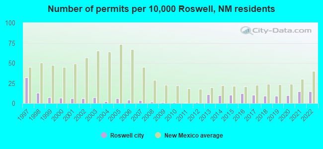
Single-family new house construction building permits:
- 2022: 67 buildings, average cost: $159,800
- 2021: 67 buildings, average cost: $157,100
- 2020: 44 buildings, average cost: $171,400
- 2019: 41 buildings, average cost: $170,000
- 2018: 41 buildings, average cost: $174,400
- 2017: 48 buildings, average cost: $181,500
- 2016: 56 buildings, average cost: $165,100
- 2015: 47 buildings, average cost: $165,400
- 2014: 44 buildings, average cost: $173,000
- 2013: 50 buildings, average cost: $189,600
- 2012: 6 buildings, average cost: $176,300
- 2011: 4 buildings, average cost: $176,300
- 2010: 5 buildings, average cost: $176,300
- 2009: 5 buildings, average cost: $176,300
- 2008: 9 buildings, average cost: $176,400
- 2007: 16 buildings, average cost: $176,300
- 2006: 20 buildings, average cost: $176,600
- 2005: 27 buildings, average cost: $175,200
- 2004: 11 buildings, average cost: $189,700
- 2003: 33 buildings, average cost: $116,800
- 2002: 29 buildings, average cost: $117,100
- 2001: 27 buildings, average cost: $115,900
- 2000: 30 buildings, average cost: $122,700
- 1999: 34 buildings, average cost: $89,600
- 1998: 60 buildings, average cost: $90,200
- 1997: 146 buildings, average cost: $84,700
| Here: | 3.7% |
| New Mexico: | 3.6% |

Population change in the 1990s: +666 (+1.5%).
- Educational services (10.3%)
- Health care (9.2%)
- Accommodation & food services (7.5%)
- Construction (6.7%)
- Public administration (4.8%)
- Transportation equipment (3.9%)
- Finance & insurance (3.7%)
- Construction (11.2%)
- Agriculture, forestry, fishing & hunting (6.5%)
- Accommodation & food services (6.2%)
- Educational services (6.1%)
- Transportation equipment (5.9%)
- Health care (5.1%)
- Public administration (4.7%)
- Educational services (15.4%)
- Health care (14.1%)
- Accommodation & food services (9.1%)
- Finance & insurance (5.7%)
- Social assistance (5.6%)
- Public administration (5.0%)
- Food & beverage stores (4.9%)
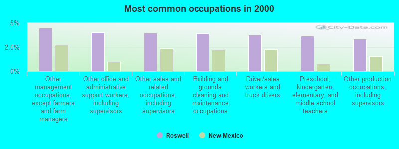
- Other management occupations, except farmers and farm managers (4.5%)
- Other office and administrative support workers, including supervisors (4.0%)
- Other sales and related occupations, including supervisors (3.9%)
- Building and grounds cleaning and maintenance occupations (3.9%)
- Driver/sales workers and truck drivers (3.7%)
- Preschool, kindergarten, elementary, and middle school teachers (3.6%)
- Other production occupations, including supervisors (3.3%)

- Driver/sales workers and truck drivers (6.7%)
- Other management occupations, except farmers and farm managers (4.8%)
- Agricultural workers, including supervisors (4.7%)
- Electrical equipment mechanics and other installation, maintenance, and repair workers, including supervisors (4.7%)
- Other production occupations, including supervisors (4.3%)
- Building and grounds cleaning and maintenance occupations (4.1%)
- Other sales and related occupations, including supervisors (3.8%)

- Preschool, kindergarten, elementary, and middle school teachers (6.4%)
- Secretaries and administrative assistants (6.4%)
- Other office and administrative support workers, including supervisors (5.1%)
- Information and record clerks, except customer service representatives (4.2%)
- Other management occupations, except farmers and farm managers (4.1%)
- Other sales and related occupations, including supervisors (4.1%)
- Cashiers (3.9%)
Average climate in Roswell, New Mexico
Based on data reported by over 4,000 weather stations


|
|


Earthquake activity:
Roswell-area historical earthquake activity is significantly above New Mexico state average. It is 430% greater than the overall U.S. average.On 4/14/1995 at 00:32:56, a magnitude 5.7 (5.6 MB, 5.7 MS, 5.7 MW, Depth: 11.1 mi, Class: Moderate, Intensity: VI - VII) earthquake occurred 225.5 miles away from Roswell center
On 1/2/1992 at 11:45:35, a magnitude 5.0 (4.6 MB, 5.0 LG, Depth: 3.1 mi) earthquake occurred 110.3 miles away from the city center
On 3/26/2020 at 15:16:27, a magnitude 5.0 (5.0 MW, Depth: 5.9 mi) earthquake occurred 119.0 miles away from Roswell center
On 6/16/1978 at 11:46:54, a magnitude 5.3 (4.4 MB, 4.6 UK, 5.3 ML) earthquake occurred 219.1 miles away from Roswell center
On 1/29/1990 at 13:16:10, a magnitude 4.8 (4.5 MB, 4.8 LG, Depth: 7.5 mi, Class: Light, Intensity: IV - V) earthquake occurred 154.1 miles away from the city center
On 8/23/2011 at 05:46:18, a magnitude 5.3 (5.3 MW, Depth: 2.5 mi) earthquake occurred 254.4 miles away from Roswell center
Magnitude types: regional Lg-wave magnitude (LG), body-wave magnitude (MB), local magnitude (ML), surface-wave magnitude (MS), moment magnitude (MW)
Natural disasters:
The number of natural disasters in Chaves County (6) is a lot smaller than the US average (15).Major Disasters (Presidential) Declared: 3
Emergencies Declared: 2
Causes of natural disasters: Fires: 2, Flood: 1, Hurricane: 1, Mudslide: 1, Storm: 1, Winter Storm: 1, Other: 1 (Note: some incidents may be assigned to more than one category).

Hospitals in Roswell:
- EASTERN NEW MEXICO MEDICAL CENTER (Proprietary, provides emergency services, 405 W COUNTRY CLUB ROAD)
- LOVELACE REGIONAL HOSPITAL - ROSWELL (Physician, 117 EAST 19TH STREET)
- NEW MEXICO REHABILITATION CENTER (31 GAIL HARRIS)
- ROSWELL HOSPICE HOME CARE (1107 SOUTH MAIN STREET)
- ST MARY'S ROSWELL HOSPICE (SOUTH MAIN & CHISUM STREETS)
Nursing Homes in Roswell:
- CASA MARIA HEALTHCARE CENTER AND PECOS VALLEY REHA (1601 SOUTH MAIN STREET)
- MISSION ARCH CARE AND REHABILITATION CENTER (3200 MISSION ARCH DRIVE)
- ROSWELL NURSING CENTER (3200 MISSION ARCH)
- SUNSET VILLA CARE CENTER (1515 SOUTH SUNSET)
- SUNSET VILLA NURSING HOME (1515 S SUNSET AVE)
Dialysis Facilities in Roswell:
Home Health Centers in Roswell:
Airports and heliports located in Roswell:
- Roswell International Air Center Airport (ROW) (Runways: 2, Commercial Ops: 518, Air Taxi Ops: 6,551, Itinerant Ops: 7,384, Local Ops: 3,127, Military Ops: 29,350)
- Benedict Airpark Airport (NM20) (Runways: 1)
- Jenkins Airport (NM87) (Runways: 2)
- Lovelace Regional Hospital - Roswell Heliport (NM93)
Colleges/Universities in Roswell:
Other colleges/universities with over 2000 students near Roswell:
- Eastern New Mexico University-Main Campus (about 88 miles; Portales, NM; Full-time enrollment: 4,263)
- South Plains College (about 126 miles; Levelland, TX; FT enrollment: 7,007)
- New Mexico State University-Main Campus (about 150 miles; Las Cruces, NM; FT enrollment: 14,497)
- New Mexico State University-Dona Ana (about 151 miles; Las Cruces, NM; FT enrollment: 5,640)
- Texas Tech University Health Sciences Center (about 153 miles; Lubbock, TX; FT enrollment: 3,269)
- Texas Tech University (about 154 miles; Lubbock, TX; FT enrollment: 29,251)
- El Paso Community College (about 155 miles; El Paso, TX; FT enrollment: 19,576)
Public high schools in Roswell:
- ROSWELL HIGH (Students: 1,356, Location: 500 WEST HOBBS ST, Grades: 9-12)
- GODDARD HIGH (Students: 1,184, Location: 701 EAST COUNTRY CLUB, Grades: 9-12)
- UNIVERSITY HIGH (Location: 606 WEST O'CONNER RD, Grades: 9-12)
- NM MILITARY INSTITUTE (Location: 101 WEST COLLEGE BLV, Grades: 9-12)
Private high schools in Roswell:
Biggest public elementary/middle schools in Roswell:
- BERRENDO MIDDLE (Students: 588, Location: 485 CALLE DON TOMAS, Grades: 6-8)
- MOUNTAIN VIEW MIDDLE (Students: 438, Location: 312 EAST MTN VIEW RD, Grades: 6-8)
- WASHINGTON AVE ELEMENTARY (Students: 436, Location: 408 NORTH WASHINGTON AVE, Grades: KG-5)
- EL CAPITAN ELEMENTARY (Students: 431, Location: 2807 WEST BLAND ST, Grades: KG-5)
- MESA MIDDLE (Students: 429, Location: 1601 EAST BLAND ST, Grades: 6-8)
- BERRENDO ELEMENTARY (Students: 417, Location: 505 WEST PINE LODGE RD, Grades: KG-5)
- MONTERREY ELEMENTARY (Students: 411, Location: 910 WEST GAYLE ST, Grades: KG-5)
- DEL NORTE ELEMENTARY (Students: 410, Location: 2701 NORTH GARDEN AVE, Grades: KG-5)
- MILITARY HGTS ELEMENTARY (Students: 360, Location: 1900 NORTH MICHIGAN, Grades: KG-5)
- MISSOURI AVE ELEMENTARY (Students: 340, Location: 700 SOUTH MISSOURI AVE, Grades: KG-5)
Private elementary/middle school in Roswell:
Points of interest:
Notable locations in Roswell: Roswell Industrial Air Center (A), Roswell Country Club (B), Roswell Weather Station (C), City of Roswell Fire Department Station 6 (D), City of Roswell Fire Department Station 5 (E), City of Roswell Fire Department Station 4 (F), City of Roswell Fire Department Station 3 (G), Museum of the Horse (H), City of Roswell Fire Department Station 1 (I), City of Roswell Fire Department Station 2 (J), Historical Center for Southeast New Mexico (K), Roswell Museum and Art Center (L), Milne-Bush Ranch (M), South Springs Ranch Outbuildings (N), Telephone Building Roswell (O), Urton Orchards Farmhouse and Milkhouse (P), J P White and T Lou House (Q), Saunders-Crosby House (R), Millhiser-Baker Farmhouse (S). Display/hide their locations on the map
Shopping Centers: Roswell Mall (1), Broadmoor Shopping Center (2). Display/hide their locations on the map
Churches in Roswell include: Peoples Baptist Church (A), Roswell Baptist Church (B), Central Church of the Nazarene (C), First Church of Christ Scientist (D), South Manor Baptist Church (E), Poor Clares Monastery (F), First Spanish Baptist Church (G), Mountain View Baptist Church (H), Westside Baptist Church (I). Display/hide their locations on the map
Cemetery: South Park Cemetery (1). Display/hide its location on the map
Parks in Roswell include: Cahoon Park (1), High Plains Historical Marker (2), Chisums South Springs Ranch Historical Marker (3), Castano de Sosas Route Historical Marker (4), Chisum Trail Historical Marker (5), Hondo Park (6), Carpenter Park (7). Display/hide their locations on the map
Tourist attractions: International UFO Museum & Research Center (114 North Main Street) (1), Robert H Goddard Planetarium (Museums; 11th & N Main) (2), Schools-Public - Roswell- Administrative Offices- Planetarium (Museums; 11 & W Martin Street) (3), Anderson Museum Of Contemporary Art (409 East College Boulevard) (4), Historical Society for Southeast New Mexico (Museums; 200 North Lea Avenue) (5), Roswell-City - Museum & Art Center (Cultural Attractions- Events- & Facilities; 11th Street & Main) (6), Wilson Cobb History & Genealogy Research Lbrry (Cultural Attractions- Events- & Facilities; 301 South Richardson Avenue) (7), American Music & Vending (Amusement & Theme Parks; 2503 North Michigan Avenue) (8), Roswell Visitor Center (426 North Main Street) (9). Display/hide their approximate locations on the map
Hotels: Super 8 Motel (3575 North Main Street) (1), Cozy Cowboy Furnished Rentals (1205 North Lea Avenue) (2), Crane Motel (1212 West 2nd Street) (3), Ramada Limited (2803 West 2nd Street) (4), Jd's Patio and Grille (2000 North Main Street) (5), Budget Inn (2200 West 2nd Street) (6), Budget Inn West (2200 West 2nd Street) (7), Best Western El Rancho Palacio (2205 North Main Street) (8), Leisure Inn (2700 West 2nd Street) (9). Display/hide their approximate locations on the map
Courts: New Mexico State - Child Support-9th Judicial District- Roswell Field (400 North Pennsylvania Avenue) (1), Magistrate Court (400 North Virginia Avenue) (2), Social Security Administration - Roswell OFC (501 East 5th Street) (3), Municipal Court (403 North Richardson) (4), New Mexico State Government - District Court- Courthouse Roswell- Court C (400 North Pennsylvania Avenue) (5), United States Government - Courts Federal- District Court- District Judges' Cham (500 North Richardson Avenue) (6). Display/hide their approximate locations on the map
Birthplace of: Demi Moore - Actress, John Denver - Singer-songwriter, Susan Graham - Singer, Michael Levitt (producer) - Television producer, Austin St. John - Film actor, Joe Skeen - Politician, Laura E. Gómez - Professor of Law, Mike E. Smith - Jockey, Paul K. Carlton, Jr. - General, Peter Guttman (photographer) - Television personality.
Drinking water stations with addresses in Roswell and their reported violations in the past:
ROSWELL MUNICIPAL WATER SYSTEM (Population served: 48,500, Groundwater):Past monitoring violations:BERRENDO COOPERATIVE WUA (Address: 2004 E 19TH STREET , Population served: 3,220, Groundwater):
- Follow-up Or Routine LCR Tap M/R - In OCT-01-2007, Contaminant: Lead and Copper Rule. Follow-up actions: St No addtl Formal Action needed (APR-06-2011), St Compliance achieved (NOV-29-2011)
- Follow-up Or Routine LCR Tap M/R - In OCT-01-2004, Contaminant: Lead and Copper Rule. Follow-up actions: St No addtl Formal Action needed (APR-06-2011), St Compliance achieved (NOV-29-2011)
- One minor monitoring violation
Past monitoring violations:CUMBERLAND COOPERATIVE WUA (Population served: 583, Groundwater):
- Initial Tap Sampling for Pb and Cu - In JAN-01-1993, Contaminant: Lead and Copper Rule. Follow-up actions: St Public Notif requested (NOV-16-2004), St Violation/Reminder Notice (NOV-16-2004), St Public Notif received (JUN-01-2005), St Compliance achieved (AUG-23-2005)
- Initial Tap Sampling for Pb and Cu - In JAN-01-1993, Contaminant: Lead and Copper Rule. Follow-up actions: St Public Notif requested (NOV-16-2004), St Violation/Reminder Notice (NOV-16-2004), St Public Notif received (JUN-01-2005), St Compliance achieved (AUG-23-2005)
Past monitoring violations:NORTH PARK MDWCA (Population served: 300, Groundwater):
- Follow-up Or Routine LCR Tap M/R - In JAN-01-1994, Contaminant: Lead and Copper Rule. Follow-up actions: St Public Notif requested (NOV-08-2004), St Violation/Reminder Notice (NOV-08-2004), St Compliance achieved (JUL-26-2005)
- Follow-up Or Routine LCR Tap M/R - In JAN-01-1994, Contaminant: Lead and Copper Rule. Follow-up actions: St Public Notif requested (NOV-08-2004), St Violation/Reminder Notice (NOV-08-2004), St Compliance achieved (JUL-26-2005)
Past health violations:Past monitoring violations:
- MCL, Monthly (TCR) - In JUL-2011, Contaminant: Coliform. Follow-up actions: St Public Notif requested (AUG-04-2011), St Violation/Reminder Notice (AUG-04-2011), St Public Notif received (AUG-20-2011), St Compliance achieved (DEC-16-2011)
- MCL, Acute (TCR) - In MAY-2008, Contaminant: Coliform. Follow-up actions: St Site Visit (enforcement) (JUN-05-2008), St Boil Water Order (JUN-05-2008), St Compliance achieved (JUN-05-2008), St Violation/Reminder Notice (JUN-09-2008), St Public Notif requested (JUN-09-2008), St AO (w/o penalty) issued (JUN-13-2008), St Public Notif received (JUN-30-2008)
- MCL, Monthly (TCR) - In MAY-2008, Contaminant: Coliform. Follow-up actions: St Compliance achieved (JUN-05-2008), St Public Notif requested (JUN-09-2008), St Violation/Reminder Notice (JUN-09-2008), St AO (w/o penalty) issued (JUN-13-2008), St Public Notif received (JUN-30-2008)
- MCL, Monthly (TCR) - In SEP-2007, Contaminant: Coliform. Follow-up actions: St Public Notif requested (SEP-21-2007), St Violation/Reminder Notice (SEP-21-2007), St AO (w/o penalty) issued (JUN-13-2008), St Public Notif received (JUN-30-2008), St Compliance achieved (NOV-13-2008)
- Lead Consumer Notice - In DEC-30-2013, Contaminant: Lead and Copper Rule. Follow-up actions: St Violation/Reminder Notice (FEB-19-2014)
- Monitoring, Source Water (GWR) - In DEC-30-2012, Contaminant: E. COLI. Follow-up actions: St Public Notif requested (JAN-09-2013), St Violation/Reminder Notice (JAN-09-2013), St Public Notif received (NOV-04-2013), St Compliance achieved (NOV-19-2013)
- Monitoring, Repeat Major (TCR) - In DEC-2012, Contaminant: Coliform (TCR). Follow-up actions: St Compliance achieved (NOV-19-2013)
- Monitoring, Source Water (GWR) - In MAY-14-2010, Contaminant: E. COLI. Follow-up actions: St Public Notif requested (MAY-20-2010), St Violation/Reminder Notice (MAY-20-2010), St Public Notif received (MAY-27-2010), St Compliance achieved (SEP-01-2011)
- Monitoring, Repeat Major (TCR) - In MAY-2010, Contaminant: Coliform (TCR). Follow-up actions: St Public Notif requested (MAY-20-2010), St Violation/Reminder Notice (MAY-20-2010), St Public Notif received (MAY-27-2010), St Compliance achieved (SEP-01-2011)
- 2 routine major monitoring violations
- One minor monitoring violation
- 2 regular monitoring violations
- 2 other older monitoring violations
| This city: | 2.7 people |
| New Mexico: | 2.5 people |
| This city: | 68.5% |
| Whole state: | 65.5% |
| This city: | 7.9% |
| Whole state: | 8.2% |
Likely homosexual households (counted as self-reported same-sex unmarried-partner households)
- Lesbian couples: 0.4% of all households
- Gay men: 0.2% of all households
People in group quarters in Roswell in 2010:
- 792 people in college/university student housing
- 216 people in nursing facilities/skilled-nursing facilities
- 204 people in local jails and other municipal confinement facilities
- 176 people in workers' group living quarters and job corps centers
- 55 people in other noninstitutional facilities
- 19 people in group homes for juveniles (non-correctional)
- 13 people in correctional facilities intended for juveniles
- 12 people in emergency and transitional shelters (with sleeping facilities) for people experiencing homelessness
- 2 people in group homes intended for adults
People in group quarters in Roswell in 2000:
- 355 people in college dormitories (includes college quarters off campus)
- 322 people in nursing homes
- 204 people in local jails and other confinement facilities (including police lockups)
- 182 people in job corps and vocational training facilities
- 62 people in other noninstitutional group quarters
- 33 people in religious group quarters
- 15 people in hospitals or wards for drug/alcohol abuse
- 13 people in short-term care, detention or diagnostic centers for delinquent children
- 6 people in homes for the mentally ill
Banks with most branches in Roswell (2011 data):
- Pioneer Bank: Penn Avenue Branch, at 3000 North Main Street, South Sunset Avenue Branch, North Main Street Branch, St. Mary's Place Branch. Info updated 2011/07/21: Bank assets: $594.7 mil, Deposits: $436.4 mil, local headquarters, positive income, 13 total offices
- Bank of the Southwest: North Branch - Roswell Branch, South Branch, Messenger Service, Drive-Up Facility, Bank Of The Southwest. Info updated 2006/11/03: Bank assets: $156.7 mil, Deposits: $138.0 mil, local headquarters, positive income, Commercial Lending Specialization, 14 total offices, Holding Company: New Mexico National Financial Incorporated
- Wells Fargo Bank, National Association: Roswell North Branch, Roswell South Branch, Roswell Branch. Info updated 2011/04/05: Bank assets: $1,161,490.0 mil, Deposits: $905,653.0 mil, headquarters in Sioux Falls, SD, positive income, 6395 total offices, Holding Company: Wells Fargo & Company
- The James Polk Stone Community Bank: South Branch at 1801 South Main, branch established on 2004/09/01; The Roswell National Bank Branch at 1901 North Main, branch established on 2003/01/02. Info updated 2010/09/10: Bank assets: $182.2 mil, Deposits: $160.7 mil, headquarters in Portales, NM, positive income, 7 total offices, Holding Company: James Polk Stone Community Bancshares, Inc.
- Valley Bank of Commerce: Valley Bank Of Commerce at 217 West 2nd Street, branch established on 1978/02/01; North Main Branch at 2426 North Main Street, branch established on 1986/11/17. Info updated 2006/11/03: Bank assets: $140.0 mil, Deposits: $125.8 mil, local headquarters, positive income, Agricultural Specialization, 3 total offices, Holding Company: Commerce Bancshares Of Roswell, Inc.
- First American Bank: Roswell Branch at 111 East Fifth St., branch established on 1998/07/31; Roswell-Berrendo Branch at 3220 N Main St, branch established on 2000/01/26. Info updated 2010/06/26: Bank assets: $732.3 mil, Deposits: $605.7 mil, headquarters in Artesia, NM, positive income, Commercial Lending Specialization, 14 total offices, Holding Company: First Artesia Bancshares, Inc.
- Bank of America, National Association: Roswell Main Branch at 500 North Main Street, branch established on 1960/10/03. Info updated 2009/11/18: Bank assets: $1,451,969.3 mil, Deposits: $1,077,176.8 mil, headquarters in Charlotte, NC, positive income, 5782 total offices, Holding Company: Bank Of America Corporation
- Washington Federal: First Federal Bank Branch at 300 N Pennsylvania Ave, branch established on 1920/01/01. Info updated 2011/12/19: Bank assets: $13,653.0 mil, Deposits: $8,905.8 mil, headquarters in Seattle, WA, positive income, Mortgage Lending Specialization, 174 total offices
- First National Bank Texas: Roswell Banking Center Rc-915 at 4500 North Main Street, branch established on 2011/11/04. Info updated 2006/11/03: Bank assets: $944.3 mil, Deposits: $815.9 mil, headquarters in Killeen, TX, positive income, Mortgage Lending Specialization, 250 total offices, Holding Company: First Community Bancshares, Inc.
For population 15 years and over in Roswell:

- Never married: 36.3%
- Now married: 41.9%
- Separated: 1.6%
- Widowed: 6.2%
- Divorced: 13.9%
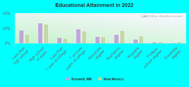
For population 25 years and over in Roswell:
- High school or higher: 81.5%
- Bachelor's degree or higher: 18.4%
- Graduate or professional degree: 7.3%
- Unemployed: 9.7%
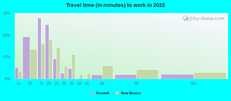
- Mean travel time to work (commute): 17.3 minutes
| Here: | 13.5 |
| New Mexico average: | 12.6 |
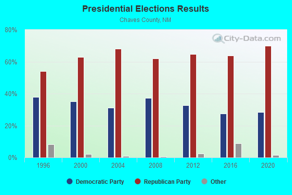
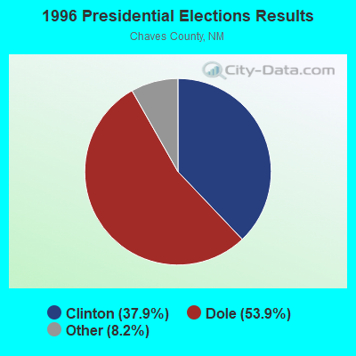
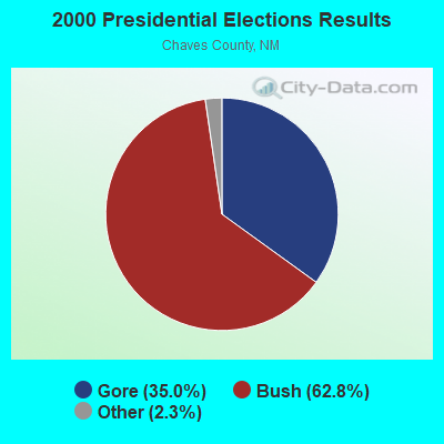

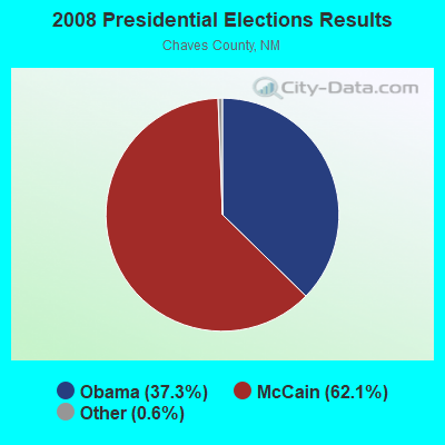

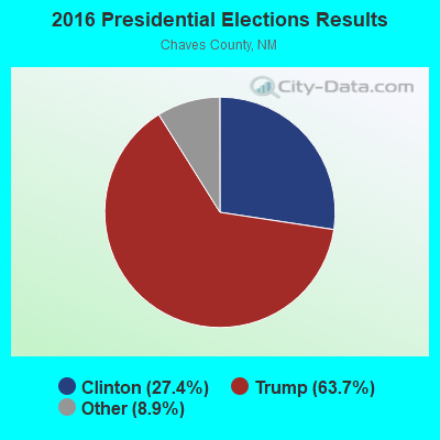
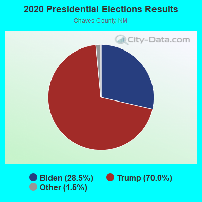
Graphs represent county-level data. Detailed 2008 Election Results
Religion statistics for Roswell, NM (based on Chaves County data)
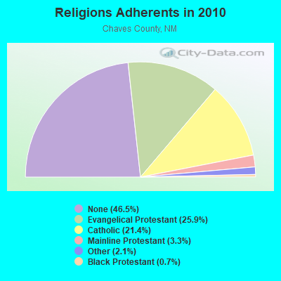
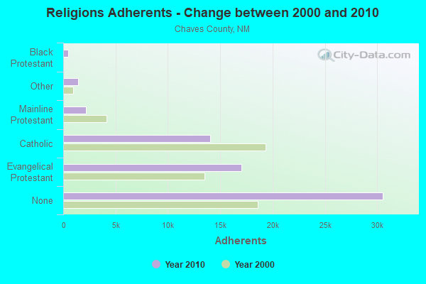
| Religion | Adherents | Congregations |
|---|---|---|
| Evangelical Protestant | 17,026 | 59 |
| Catholic | 14,031 | 6 |
| Mainline Protestant | 2,193 | 11 |
| Other | 1,399 | 10 |
| Black Protestant | 448 | 3 |
| None | 30,548 | - |
Food Environment Statistics:
| Here: | 1.44 / 10,000 pop. |
| New Mexico: | 1.44 / 10,000 pop. |
| Chaves County: | 0.32 / 10,000 pop. |
| New Mexico: | 0.21 / 10,000 pop. |
| Here: | 0.32 / 10,000 pop. |
| New Mexico: | 0.32 / 10,000 pop. |
| Chaves County: | 4.16 / 10,000 pop. |
| New Mexico: | 4.06 / 10,000 pop. |
| Here: | 7.85 / 10,000 pop. |
| New Mexico: | 7.12 / 10,000 pop. |
| This county: | 8.1% |
| State: | 6.4% |
| Chaves County: | 25.6% |
| New Mexico: | 22.1% |
| Here: | 10.6% |
| New Mexico: | 11.5% |
Health and Nutrition:
| This city: | 48.8% |
| New Mexico: | 49.0% |
| This city: | 47.0% |
| New Mexico: | 48.1% |
| Roswell: | 28.6 |
| New Mexico: | 28.6 |
| Roswell: | 20.8% |
| New Mexico: | 20.7% |
| This city: | 10.8% |
| New Mexico: | 10.1% |
| Roswell: | 6.8 |
| New Mexico: | 6.8 |
| Roswell: | 34.3% |
| State: | 34.6% |
| Roswell: | 54.8% |
| State: | 55.9% |
| This city: | 79.0% |
| State: | 80.3% |
More about Health and Nutrition of Roswell, NM Residents
| Local government employment and payroll (March 2022) | |||||
| Function | Full-time employees | Monthly full-time payroll | Average yearly full-time wage | Part-time employees | Monthly part-time payroll |
|---|---|---|---|---|---|
| Police Protection - Officers | 86 | $517,590 | $72,222 | 4 | $3,746 |
| Firefighters | 80 | $491,000 | $73,650 | 0 | $0 |
| Other and Unallocable | 62 | $253,219 | $49,010 | 1 | $481 |
| Parks and Recreation | 53 | $194,664 | $44,075 | 9 | $13,106 |
| Sewerage | 45 | $160,811 | $42,883 | 0 | $0 |
| Streets and Highways | 32 | $153,893 | $57,710 | 0 | $0 |
| Solid Waste Management | 29 | $109,304 | $45,229 | 0 | $0 |
| Other Government Administration | 24 | $79,266 | $39,633 | 0 | $0 |
| Water Supply | 19 | $75,025 | $47,384 | 0 | $0 |
| Local Libraries | 16 | $61,022 | $45,767 | 5 | $5,123 |
| Police - Other | 16 | $60,574 | $45,431 | 0 | $0 |
| Transit | 15 | $54,927 | $43,942 | 1 | $2,375 |
| Financial Administration | 14 | $73,242 | $62,779 | 0 | $0 |
| Airports | 11 | $45,245 | $49,358 | 0 | $0 |
| Judicial and Legal | 10 | $43,939 | $52,727 | 1 | $1,207 |
| Welfare | 1 | $4,209 | $50,508 | 1 | $1,094 |
| Totals for Government | 513 | $2,377,930 | $55,624 | 22 | $27,132 |
Roswell government finances - Expenditure in 2021 (per resident):
- Construction - General - Other: $8,602,000 ($181.52)
Regular Highways: $3,948,000 ($83.31)
Water Utilities: $2,899,000 ($61.17)
Housing and Community Development: $1,060,000 ($22.37)
Sewerage: $573,000 ($12.09)
Air Transportation: $365,000 ($7.70)
Solid Waste Management: $130,000 ($2.74)
Parks and Recreation: $85,000 ($1.79)
Transit Utilities: $48,000 ($1.01)
Libraries: $15,000 ($0.32)
Police Protection: $7,000 ($0.15)
- Current Operations - Solid Waste Management: $10,953,000 ($231.12)
Parks and Recreation: $4,519,000 ($95.36)
Financial Administration: $4,119,000 ($86.92)
Air Transportation: $3,962,000 ($83.60)
Central Staff Services: $3,503,000 ($73.92)
Water Utilities: $3,397,000 ($71.68)
Regular Highways: $3,143,000 ($66.32)
Sewerage: $2,115,000 ($44.63)
Police Protection: $1,175,000 ($24.79)
General - Other: $1,116,000 ($23.55)
Miscellaneous Commercial Activities - Other: $632,000 ($13.34)
Transit Utilities: $526,000 ($11.10)
Judicial and Legal Services: $419,000 ($8.84)
Local Fire Protection: $303,000 ($6.39)
Libraries: $164,000 ($3.46)
- Intergovernmental to Local - Other - Public Welfare - Other: $670,000 ($14.14)
- Other Capital Outlay - Solid Waste Management: $2,666,000 ($56.26)
Regular Highways: $816,000 ($17.22)
Water Utilities: $680,000 ($14.35)
Sewerage: $339,000 ($7.15)
Transit Utilities: $265,000 ($5.59)
Police Protection: $250,000 ($5.28)
Local Fire Protection: $242,000 ($5.11)
Parks and Recreation: $141,000 ($2.98)
Miscellaneous Commercial Activities - Other: $122,000 ($2.57)
Libraries: $20,000 ($0.42)
Air Transportation: $18,000 ($0.38)
Central Staff Services: $9,000 ($0.19)
- Total Salaries and Wages: $38,780,000 ($818.32)
Roswell government finances - Revenue in 2021 (per resident):
- Charges - Solid Waste Management: $6,380,000 ($134.63)
Sewerage: $5,755,000 ($121.44)
Air Transportation: $2,593,000 ($54.72)
Parks and Recreation: $1,074,000 ($22.66)
Other: $731,000 ($15.43)
Miscellaneous Commercial Activities: $455,000 ($9.60)
- Federal Intergovernmental - Air Transportation: $1,184,000 ($24.98)
Transit Utilities: $1,147,000 ($24.20)
Public Welfare: $112,000 ($2.36)
- Local Intergovernmental - Public Welfare: $670,000 ($14.14)
- Miscellaneous - Rents: $2,484,000 ($52.42)
General Revenue - Other: $1,691,000 ($35.68)
Fines and Forfeits: $185,000 ($3.90)
Donations From Private Sources: $137,000 ($2.89)
Interest Earnings: $47,000 ($0.99)
Sale of Property: $7,000 ($0.15)
- Revenue - Water Utilities: $10,002,000 ($211.06)
Transit Utilities: $29,000 ($0.61)
- State Intergovernmental - Public Welfare: $23,405,000 ($493.88)
Highways: $1,098,000 ($23.17)
Housing and Community Development: $884,000 ($18.65)
General Local Government Support: $713,000 ($15.05)
Water Utilities: $661,000 ($13.95)
Other: $25,000 ($0.53)
- Tax - General Sales and Gross Receipts: $21,976,000 ($463.73)
Property: $5,631,000 ($118.82)
Other Selective Sales: $3,094,000 ($65.29)
Roswell government finances - Debt in 2021 (per resident):
- Long Term Debt - Outstanding Nonguaranteed - Industrial Revenue: $33,377,000 ($704.30)
Beginning Outstanding - Unspecified Public Purpose: $32,952,000 ($695.34)
Beginning Outstanding - Public Debt for Private Purpose: $32,513,000 ($686.07)
Outstanding Unspecified Public Purpose: $30,944,000 ($652.96)
Retired Unspecified Public Purpose: $3,622,000 ($76.43)
Issue, Nonguaranteed - Public Debt for Private Purpose: $3,055,000 ($64.47)
Retired Nonguaranteed - Public Debt for Private Purpose: $2,191,000 ($46.23)
Issue, Unspecified Public Purpose: $1,614,000 ($34.06)
Roswell government finances - Cash and Securities in 2021 (per resident):
- Other Funds - Cash and Securities: $50,046,000 ($1056.05)
- Sinking Funds - Cash and Securities: $34,223,000 ($722.16)
| Businesses in Roswell, NM | ||||
| Name | Count | Name | Count | |
|---|---|---|---|---|
| Ace Hardware | 1 | La Quinta | 1 | |
| Albertsons | 1 | La-Z-Boy | 3 | |
| Applebee's | 1 | Lane Furniture | 2 | |
| Arby's | 1 | Little Caesars Pizza | 1 | |
| AutoZone | 2 | Long John Silver's | 1 | |
| Best Western | 2 | Marriott | 1 | |
| Big O Tires | 1 | MasterBrand Cabinets | 4 | |
| Budget Car Rental | 1 | Maurices | 1 | |
| Chevrolet | 1 | McDonald's | 3 | |
| Church's Chicken | 2 | Motel 6 | 1 | |
| Circle K | 1 | Nike | 4 | |
| Comfort Inn | 1 | Nissan | 1 | |
| Comfort Suites | 1 | OfficeMax | 1 | |
| Curves | 1 | Payless | 2 | |
| Dairy Queen | 2 | Pizza Hut | 1 | |
| Days Inn | 1 | RadioShack | 1 | |
| Dennys | 1 | Red Lobster | 1 | |
| Discount Tire | 1 | Rodeway Inn | 1 | |
| Famous Footwear | 1 | Rue21 | 1 | |
| FedEx | 6 | SONIC Drive-In | 4 | |
| Foot Locker | 1 | Sam's Club | 1 | |
| Ford | 1 | Sears | 1 | |
| GNC | 1 | Sprint Nextel | 1 | |
| GameStop | 1 | Starbucks | 2 | |
| Goodwill | 2 | Super 8 | 1 | |
| H&R Block | 2 | T-Mobile | 2 | |
| Hilton | 1 | Target | 1 | |
| Hobby Lobby | 1 | Toyota | 1 | |
| Holiday Inn | 2 | True Value | 1 | |
| Home Depot | 1 | U-Haul | 2 | |
| Honda | 1 | UPS | 6 | |
| IHOP | 1 | Vans | 1 | |
| JCPenney | 1 | Walgreens | 2 | |
| Jones New York | 3 | Walmart | 1 | |
| KFC | 2 | Wendy's | 1 | |
| Kmart | 1 | |||
Strongest AM radio stations in Roswell:
- KINF (1020 AM; 50 kW; ROSWELL, NM; Owner: JAMES CRYSTAL HOLDINGS OF NEW MEXICO, INC.)
- KBIM (910 AM; 5 kW; ROSWELL, NM; Owner: KING BROADCASTING COMPANY)
- KPSA (1230 AM; 1 kW; ROSWELL, NM; Owner: ROSWELL RADIO, INC.)
- KCRX (1430 AM; 5 kW; ROSWELL, NM; Owner: ROSENDO CASAREZ, JR.)
- KRDD (1320 AM; 1 kW; ROSWELL, NM; Owner: TRINNIE B. ESPINOZA)
- KICA (980 AM; 50 kW; CLOVIS, NM; Owner: BROADCAST ENTERTAINMENT CORPORATION)
- KMUL (1380 AM; 50 kW; MULESHOE, TX; Owner: BROADCAST ENTERTAINMENT CORPORATION)
- KKOB (770 AM; 50 kW; ALBUQUERQUE, NM; Owner: CITADEL BROADCASTING COMPANY)
- KELP (1590 AM; 50 kW; EL PASO, TX; Owner: MCCLATCHEY BROADCASTING)
- KBUY (1360 AM; 5 kW; RUIDOSO, NM; Owner: WALTON STATIONS-NEW MEXICO, INC.)
- KIJN (1060 AM; daytime; 10 kW; FARWELL, TX; Owner: METROPOLITIAN RADIO GROUP, INC.)
- KTNN (660 AM; 50 kW; WINDOW ROCK, AZ; Owner: THE NAVAJO NATION)
- KTSM (690 AM; 10 kW; EL PASO, TX; Owner: CCB TEXAS LICENSES, L.P.)
Strongest FM radio stations in Roswell:
- K213EA (90.5 FM; ROSWELL, NM; Owner: CALVARY CHAPEL OF TWIN FALLS, INC.)
- K276ED (103.1 FM; ROSWELL, NM; Owner: ROSWELL INTERARTS ORGANIZATION)
- K216BJ (91.1 FM; ROSWELL, NM; Owner: EASTERN NEW MEXICO UNIVERSITY)
- KEND (106.5 FM; ROSWELL, NM; Owner: BURKBERY COMMUNICATIONS GROUP INC.)
- KSFX (100.5 FM; ROSWELL, NM; Owner: ROSWELL RADIO, INC.)
- KWFL (99.5 FM; ROSWELL, NM; Owner: ROSWELL CHRISTIAN RADIO, INC.)
- K250AB (97.9 FM; ROSWELL, NM; Owner: CONNECTION COMMUNICATIONS ASSOC., INC.)
- KBCQ (97.1 FM; ROSWELL, NM; Owner: ROSWELL RADIO, INC.)
- KMOU (104.7 FM; ROSWELL, NM; Owner: ROSWELL RADIO, INC.)
- KBIM-FM (94.9 FM; ROSWELL, NM; Owner: KING BROADCASTING COMPANY)
- K249DD (97.7 FM; RUIDOSO, NM; Owner: ROSWELL CHRISTIAN RADIO, INC.)
- KNMB (96.7 FM; CLOUDCROFT, NM; Owner: MTD, INC.)
- KIDX (101.5 FM; RUIDOSO, NM; Owner: MTD, INC.)
- K240CN (95.9 FM; RUIDOSO, NM; Owner: FRIENDS OF KHFM-RUIDOSO)
- K297AE (107.3 FM; RUIDOSO, NM; Owner: FAMILY LIFE BROADCASTING SYSTEM)
- KTZA (92.9 FM; ARTESIA, NM; Owner: PECOS VALLEY BROADCASTING COMPANY)
- K208DR (89.5 FM; ROSWELL, NM; Owner: EDUCATIONAL MEDIA FOUNDATION)
TV broadcast stations around Roswell:
- KPLP-LP (Channel 44; ROSWELL, NM; Owner: PRIME TIME CHRISTIAN B/CING., INC.)
- KRPV (Channel 27; ROSWELL, NM; Owner: PRIME TIME CHRISTIAN BROADCASTING, INC.)
- KKGD-LP (Channel 33; ROSWELL, NM; Owner: PRIME TIME CHRISTIAN BROADCASTING, INC.)
- K15FT (Channel 15; ROSWELL, NM; Owner: RAYCOM NATIONAL, INC.)
- K17EM (Channel 17; ROSWELL, NM; Owner: ACME TV LICENSES OF NEW MEXICO, LLC)
- KOBR (Channel 8; ROSWELL, NM; Owner: STANLEY S. HUBBARD REVOCABLE TRUST)
- K50FG (Channel 62; ROSWELL, NM; Owner: KOAT HEARST-ARGYLE TELEVISION, INC.)
- K13RK (Channel 13; ROSWELL, NM; Owner: KOAT HEARST-ARGYLE TELEVISION, INC.)
- National Bridge Inventory (NBI) Statistics
- 56Number of bridges
- 367ft / 112mTotal length
- $4,714,000Total costs
- 231,233Total average daily traffic
- 22,663Total average daily truck traffic
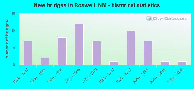
- New bridges - historical statistics
- 71930-1939
- 21940-1949
- 81950-1959
- 121960-1969
- 71970-1979
- 11980-1989
- 101990-1999
- 72000-2009
- 12010-2019
- 12020-2022
FCC Registered Antenna Towers: 451 (See the full list of FCC Registered Antenna Towers)
FCC Registered Commercial Land Mobile Towers: 8 (See the full list of FCC Registered Commercial Land Mobile Towers in Roswell, NM)
FCC Registered Private Land Mobile Towers: 4 (See the full list of FCC Registered Private Land Mobile Towers)
FCC Registered Broadcast Land Mobile Towers: 80 (See the full list of FCC Registered Broadcast Land Mobile Towers)
FCC Registered Microwave Towers: 235 (See the full list of FCC Registered Microwave Towers in this town)
FCC Registered Paging Towers: 5 (See the full list of FCC Registered Paging Towers)
FCC Registered Maritime Coast & Aviation Ground Towers: 25 (See the full list of FCC Registered Maritime Coast & Aviation Ground Towers)
FCC Registered Amateur Radio Licenses: 302 (See the full list of FCC Registered Amateur Radio Licenses in Roswell)
FAA Registered Aircraft: 71 (See the full list of FAA Registered Aircraft in Roswell)
2004 - 2018 National Fire Incident Reporting System (NFIRS) incidents
- Fire incident types reported to NFIRS in Roswell, NM
- 2,99757.8%Outside Fires
- 1,03119.9%Structure Fires
- 63112.2%Other
- 52510.1%Mobile Property/Vehicle Fires
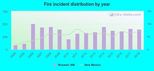 Based on the data from the years 2004 - 2018 the average number of fires per year is 346. The highest number of reported fire incidents - 507 took place in 2006, and the least - 87 in 2004. The data has a growing trend.
 When looking into fire subcategories, the most reports belonged to: Outside Fires (57.8%), and Structure Fires (19.9%).
Fire-safe hotels and motels in Roswell, New Mexico:
- Days Inn by Wyndham - Roswell, 1310 N Main St, Roswell, New Mexico 88201 , Phone: (505) 623-4021, Fax: (505) 623-0079
- Belmont Motel, 2100 West 2ND, Roswell, New Mexico 88201 , Phone: (505) 623-4522, Fax: (505) 623-2974
- Budget Inn West, 2200 W 2ND, Roswell, New Mexico 88201 , Phone: (505) 623-3811
- Rodeway Inn Of Roswell, 2803 W 2ND St, Roswell, New Mexico 88201 , Phone: (575) 623-9440, Fax: (875) 622-9708
- Budget Inn, 2101 N Main St, Roswell, New Mexico 88201 , Phone: (505) 623-6050, Fax: (505) 623-8546
- Baymont Inn & Suites, 2300 N Main St, Roswell, New Mexico 88201 , Phone: (505) 627-9900, Fax: (505) 627-9963
- Hampton Inn & Suites, 3607 N Main, Roswell, New Mexico 88201 , Phone: (505) 623-5151, Fax: (505) 623-8969
- La Quinta Inn And Suites Roswell NM, 201 E 19h St, Roswell, New Mexico 88201 , Phone: (575) 622-8000, Fax: (575) 622-8020
- 3 other hotels and motels
| Most common first names in Roswell, NM among deceased individuals | ||
| Name | Count | Lived (average) |
|---|---|---|
| John | 298 | 73.2 years |
| William | 284 | 75.4 years |
| James | 277 | 72.8 years |
| Mary | 267 | 76.6 years |
| Robert | 214 | 70.8 years |
| George | 170 | 76.7 years |
| Charles | 163 | 74.3 years |
| Frank | 114 | 75.3 years |
| Ruth | 108 | 77.9 years |
| Helen | 106 | 78.7 years |
| Most common last names in Roswell, NM among deceased individuals | ||
| Last name | Count | Lived (average) |
|---|---|---|
| Smith | 176 | 74.0 years |
| Johnson | 89 | 76.9 years |
| Brown | 89 | 80.0 years |
| Jones | 83 | 75.8 years |
| Davis | 79 | 75.0 years |
| Williams | 73 | 78.7 years |
| Sanchez | 68 | 68.5 years |
| Garcia | 68 | 69.8 years |
| Miller | 68 | 75.0 years |
| Taylor | 64 | 76.8 years |
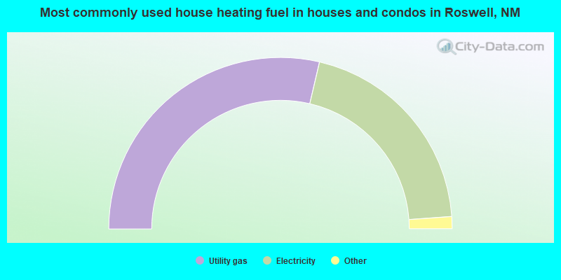
- 57.3%Utility gas
- 40.4%Electricity
- 1.5%Bottled, tank, or LP gas
- 0.7%Wood
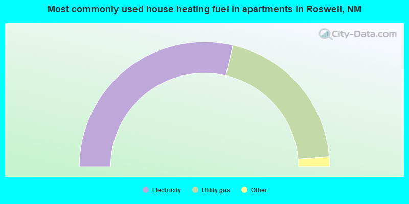
- 57.3%Electricity
- 40.1%Utility gas
- 1.5%Bottled, tank, or LP gas
- 0.4%No fuel used
- 0.4%Fuel oil, kerosene, etc.
- 0.3%Wood
Roswell compared to New Mexico state average:
- Median house value below state average.
- Median age below state average.
- Length of stay since moving in significantly above state average.
- House age above state average.
Roswell on our top lists:
- #58 on the list of "Top 101 cities with the largest percentage of people in job corps and vocational training facilities (population 1,000+)"
- #32 on the list of "Top 101 counties with highest percentage of residents voting for 3rd party candidates in the 2012 Presidential Election (pop. 50,000+)"

|
|
Total of 28 patent applications in 2008-2024.