Rosemark, Tennessee
Submit your own pictures of this place and show them to the world
- OSM Map
- General Map
- Google Map
- MSN Map

| Males: 1,177 | |
| Females: 1,138 |
| Median resident age: | 43.7 years |
| Tennessee median age: | 35.9 years |
Zip code: 38053
| Rosemark: | $98,078 |
| TN: | $65,254 |
Estimated per capita income in 2022: $44,290 (it was $25,297 in 2000)
Rosemark CCD income, earnings, and wages data
Estimated median house or condo value in 2022: $468,365 (it was $169,500 in 2000)
| Rosemark: | $468,365 |
| TN: | $284,800 |
Mean prices in 2022: all housing units: $312,315; detached houses: $317,445; townhouses or other attached units: $266,407; in 2-unit structures: $296,597; in 3-to-4-unit structures: $138,859; in 5-or-more-unit structures: $242,552; mobile homes: $127,229; occupied boats, rvs, vans, etc.: $434,364
Detailed information about poverty and poor residents in Rosemark, TN


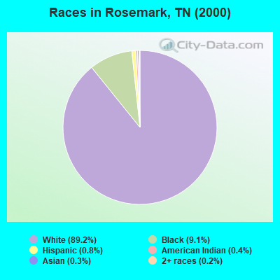
- 2,01689.2%White alone
- 2069.1%Black alone
- 190.8%Hispanic
- 90.4%American Indian alone
- 60.3%Asian alone
- 50.2%Two or more races
Races in Rosemark detailed stats: ancestries, foreign born residents, place of birth
 Recent articles from our blog. Our writers, many of them Ph.D. graduates or candidates, create easy-to-read articles on a wide variety of topics.
Current Local Time: CST time zone
Elevation: 337 feet
Land area: 34.9 square miles.
Population density: 66 people per square mile (very low).

| Rosemark CCD: | 0.8% ($1,285) |
| Tennessee: | 0.8% ($715) |
Nearest city with pop. 50,000+: Memphis, TN  (19.6 miles , pop. 650,100).
Nearest city with pop. 1,000,000+: Dallas, TX (438.4 miles , pop. 1,188,580).
Nearest cities:
), ), ), )Latitude: 35.35 N, Longitude: 89.78 W
Area code: 901

| Here: | 4.0% |
| Tennessee: | 3.0% |
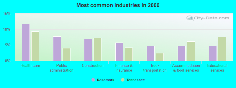
- Health care (11.6%)
- Public administration (7.7%)
- Construction (6.9%)
- Finance & insurance (5.8%)
- Truck transportation (4.7%)
- Accommodation & food services (4.7%)
- Educational services (4.7%)
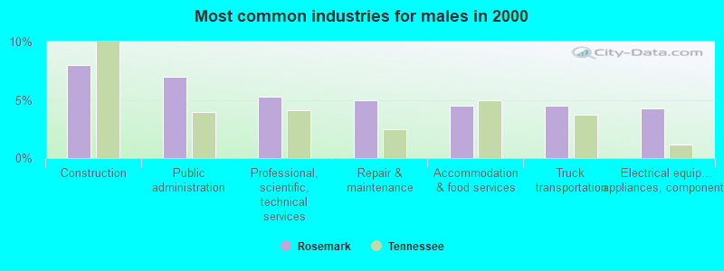
- Construction (8.0%)
- Public administration (7.0%)
- Professional, scientific, technical services (5.2%)
- Repair & maintenance (5.0%)
- Accommodation & food services (4.5%)
- Truck transportation (4.5%)
- Electrical equipment, appliances, components (4.2%)
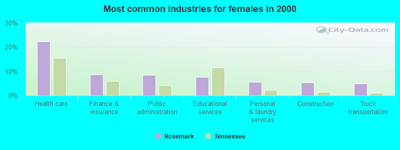
- Health care (22.4%)
- Finance & insurance (8.8%)
- Public administration (8.6%)
- Educational services (7.6%)
- Personal & laundry services (5.6%)
- Construction (5.4%)
- Truck transportation (5.0%)

- Other sales and related occupations, including supervisors (5.6%)
- Retail sales workers, except cashiers (4.6%)
- Other management occupations, except farmers and farm managers (4.5%)
- Other production occupations, including supervisors (4.5%)
- Accountants and auditors (3.9%)
- Laborers and material movers, hand (3.7%)
- Vehicle and mobile equipment mechanics, installers, and repairers (3.6%)
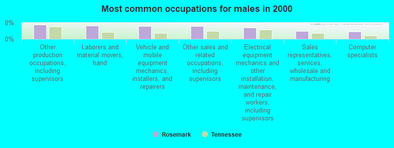
- Other production occupations, including supervisors (7.0%)
- Laborers and material movers, hand (6.6%)
- Vehicle and mobile equipment mechanics, installers, and repairers (6.4%)
- Other sales and related occupations, including supervisors (6.4%)
- Electrical equipment mechanics and other installation, maintenance, and repair workers, including supervisors (5.7%)
- Sales representatives, services, wholesale and manufacturing (3.8%)
- Computer specialists (3.6%)

- Secretaries and administrative assistants (8.0%)
- Retail sales workers, except cashiers (6.9%)
- Registered nurses (6.9%)
- Other management occupations, except farmers and farm managers (6.0%)
- Health technologists and technicians (5.8%)
- Other office and administrative support workers, including supervisors (5.6%)
- Accountants and auditors (5.2%)
Average climate in Rosemark, Tennessee
Based on data reported by over 4,000 weather stations


(lower is better)
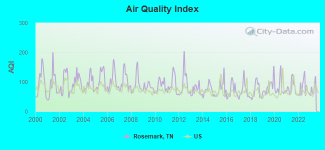
Air Quality Index (AQI) level in 2022 was 77.6. This is about average.
| City: | 77.6 |
| U.S.: | 72.6 |
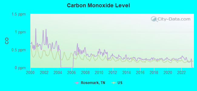
Carbon Monoxide (CO) [ppm] level in 2022 was 0.254. This is about average. Closest monitor was 14.3 miles away from the city center.
| City: | 0.254 |
| U.S.: | 0.251 |
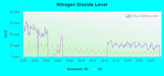
Nitrogen Dioxide (NO2) [ppb] level in 2022 was 8.51. This is significantly worse than average. Closest monitor was 7.5 miles away from the city center.
| City: | 8.51 |
| U.S.: | 5.11 |
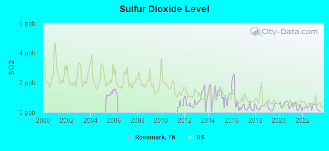
Sulfur Dioxide (SO2) [ppb] level in 2022 was 0.365. This is significantly better than average. Closest monitor was 7.5 miles away from the city center.
| City: | 0.365 |
| U.S.: | 1.515 |
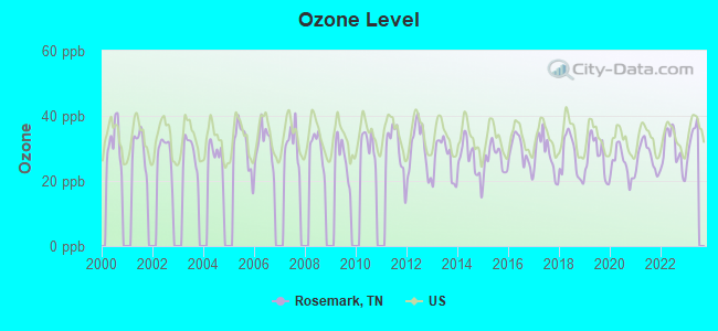
Ozone [ppb] level in 2022 was 29.4. This is about average. Closest monitor was 14.0 miles away from the city center.
| City: | 29.4 |
| U.S.: | 33.3 |
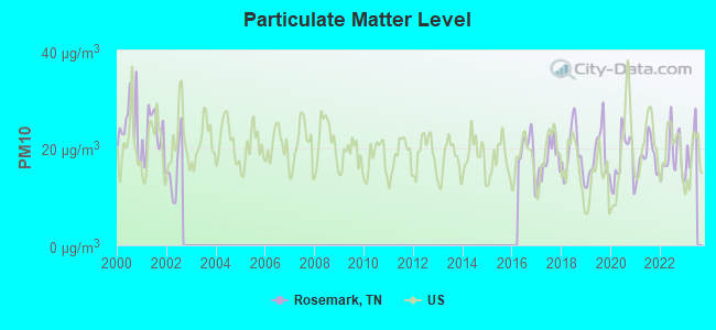
Particulate Matter (PM10) [µg/m3] level in 2022 was 18.2. This is about average. Closest monitor was 14.6 miles away from the city center.
| City: | 18.2 |
| U.S.: | 19.2 |
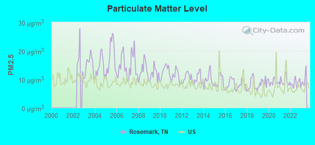
Particulate Matter (PM2.5) [µg/m3] level in 2022 was 8.53. This is about average. Closest monitor was 3.4 miles away from the city center.
| City: | 8.53 |
| U.S.: | 8.11 |
Tornado activity:
Rosemark-area historical tornado activity is above Tennessee state average. It is 106% greater than the overall U.S. average.
On 11/27/1994, a category F3 (max. wind speeds 158-206 mph) tornado 7.8 miles away from the Rosemark place center killed 3 people and injured 25 people and caused between $5,000,000 and $50,000,000 in damages.
On 12/14/1987, a category F3 tornado 7.8 miles away from the place center killed 6 people and injured 121 people and caused between $5,000,000 and $50,000,000 in damages.
Earthquake activity:
Rosemark-area historical earthquake activity is significantly above Tennessee state average. It is 377% greater than the overall U.S. average.On 3/25/1976 at 00:41:20, a magnitude 5.0 (4.9 MB, 5.0 LG, Class: Moderate, Intensity: VI - VII) earthquake occurred 36.4 miles away from Rosemark center
On 5/4/1991 at 01:18:54, a magnitude 5.0 (4.4 MB, 4.6 LG, 5.0 LG, Depth: 3.1 mi) earthquake occurred 83.7 miles away from the city center
On 4/27/1989 at 16:47:49, a magnitude 4.7 (4.6 MB, 4.7 LG, 4.3 LG, Class: Light, Intensity: IV - V) earthquake occurred 45.1 miles away from the city center
On 9/26/1990 at 13:18:51, a magnitude 5.0 (4.7 MB, 4.8 LG, 5.0 LG, Depth: 7.7 mi) earthquake occurred 126.1 miles away from Rosemark center
On 3/25/1976 at 01:00:11, a magnitude 4.5 (4.1 MB, 4.5 LG) earthquake occurred 43.1 miles away from the city center
On 4/18/2008 at 09:36:59, a magnitude 5.4 (5.1 MB, 4.8 MS, 5.4 MW, 5.2 MW) earthquake occurred 238.5 miles away from Rosemark center
Magnitude types: regional Lg-wave magnitude (LG), body-wave magnitude (MB), surface-wave magnitude (MS), moment magnitude (MW)
Natural disasters:
The number of natural disasters in Shelby County (18) is near the US average (15).Major Disasters (Presidential) Declared: 14
Emergencies Declared: 2
Causes of natural disasters: Floods: 13, Storms: 13, Tornadoes: 8, Winds: 8, Winter Storms: 2, Flash Flood: 1, Heavy Rain: 1, Hurricane: 1, Ice Storm: 1, Other: 1 (Note: some incidents may be assigned to more than one category).
Hospitals and medical centers near Rosemark:
- MILLINGTON HEALTHCARE CENTER (Nursing Home, about 7 miles away; MILLINGTON, TN)
- FMC MILLINGTON (Dialysis Facility, about 7 miles away; MILLINGTON, TN)
- DAVITA MILLINGTON (Dialysis Facility, about 8 miles away; MILLINGTON, TN)
- ARLINGTON DEVELOPMENTAL CENTER (Hospital, about 8 miles away; ARLINGTON, TN)
- THE KINGS DAUGHTERS AND SONS (Nursing Home, about 10 miles away; BARTLETT, TN)
- GALLAWAY HEALTH AND REHAB (Nursing Home, about 10 miles away; GALLAWAY, TN)
- LAYTON W WATSON NH (Nursing Home, about 10 miles away; GALLAWAY, TN)
Airports located in Rosemark:
- Ray Airport (TN01) (Runways: 1)
Colleges/universities with over 2000 students nearest to Rosemark:
- Rhodes College (about 19 miles; Memphis, TN; Full-time enrollment: 2,052)
- University of Memphis (about 21 miles; Memphis, TN; FT enrollment: 17,427)
- Southwest Tennessee Community College (about 21 miles; Memphis, TN; FT enrollment: 8,043)
- Northwest Mississippi Community College (about 52 miles; Senatobia, MS; FT enrollment: 6,607)
- Dyersburg State Community College (about 53 miles; Dyersburg, TN; FT enrollment: 2,211)
- Union University (about 57 miles; Jackson, TN; FT enrollment: 4,051)
- Jackson State Community College (about 60 miles; Jackson, TN; FT enrollment: 2,958)
Points of interest:
Notable locations in Rosemark: T L Farms (A), Bartlett Sewage Treatment Plant (B), Shelby County Fire Department Station 69 (C). Display/hide their locations on the map
Churches in Rosemark include: Pleasant Union Church (A), Bolton Methodist Church (B), Greenwood Church (C), Gildfield Church (D), Rosemark Church (E), Saint James Church (F), Pleasant Ridge Church (G), Richland Church (H), Rosemark Baptist Church (I). Display/hide their locations on the map
Cemeteries: Gildfield Cemetery (1), Pleasant Union Cemetery (2), Pleasant Ridge Cemetery (3), Smith Cemetery (4), Saint James Cemetery (5), Rosemark Cemetery (6). Display/hide their locations on the map
Streams, rivers, and creeks: Crooked Creek (A), Bull Branch (B), Raner Creek (C). Display/hide their locations on the map
| This place: | 2.7 people |
| Tennessee: | 2.5 people |
| This place: | 77.9% |
| Whole state: | 69.8% |
| This place: | 3.2% |
| Whole state: | 4.2% |
Likely homosexual households (counted as self-reported same-sex unmarried-partner households)
- Lesbian couples: 0.5% of all households
- Gay men: 0.4% of all households
| This place: | 2.1% |
| Whole state: | 13.5% |
| This place: | 1.6% |
| Whole state: | 5.8% |
For population 15 years and over in Rosemark:
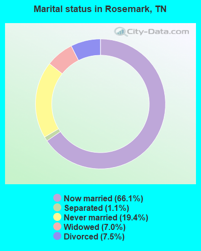
- Never married: 19.4%
- Now married: 66.1%
- Separated: 1.1%
- Widowed: 7.0%
- Divorced: 7.5%
For population 25 years and over in Rosemark:
- High school or higher: 86.3%
- Bachelor's degree or higher: 20.1%
- Graduate or professional degree: 6.2%
- Unemployed: 0.8%
- Mean travel time to work (commute): 32.6 minutes

| Here: | 9.4 |
| Tennessee average: | 13.3 |


Graphs represent county-level data. Detailed 2008 Election Results
Religion statistics for Rosemark, TN (based on Shelby County data)
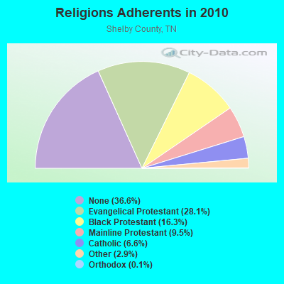
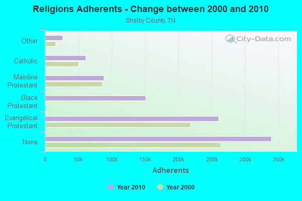
| Religion | Adherents | Congregations |
|---|---|---|
| Evangelical Protestant | 260,401 | 504 |
| Black Protestant | 150,894 | 292 |
| Mainline Protestant | 87,990 | 127 |
| Catholic | 61,202 | 29 |
| Other | 26,520 | 68 |
| Orthodox | 1,125 | 6 |
| None | 339,512 | - |
Food Environment Statistics:
| Shelby County: | 2.05 / 10,000 pop. |
| Tennessee: | 1.99 / 10,000 pop. |
| This county: | 0.14 / 10,000 pop. |
| Tennessee: | 0.17 / 10,000 pop. |
| Shelby County: | 0.54 / 10,000 pop. |
| Tennessee: | 0.65 / 10,000 pop. |
| Shelby County: | 4.25 / 10,000 pop. |
| Tennessee: | 5.16 / 10,000 pop. |
| Shelby County: | 6.12 / 10,000 pop. |
| Tennessee: | 6.56 / 10,000 pop. |
| Shelby County: | 11.3% |
| Tennessee: | 11.4% |
| Shelby County: | 32.8% |
| Tennessee: | 30.2% |
| This county: | 9.2% |
| Tennessee: | 13.5% |
4.35% of this county's 2021 resident taxpayers lived in other counties in 2020 ($59,303 average adjusted gross income)
| Here: | 4.35% |
| Tennessee average: | 8.49% |
0.02% of residents moved from foreign countries ($242 average AGI)
Shelby County: 0.02% Tennessee average: 0.02%
Top counties from which taxpayers relocated into this county between 2020 and 2021:
| from DeSoto County, MS | |
| from Fayette County, TN | |
| from Tipton County, TN |
5.27% of this county's 2020 resident taxpayers moved to other counties in 2021 ($68,956 average adjusted gross income)
| Here: | 5.27% |
| Tennessee average: | 7.40% |
0.02% of residents moved to foreign countries ($220 average AGI)
Shelby County: 0.02% Tennessee average: 0.01%
Top counties to which taxpayers relocated from this county between 2020 and 2021:
| to DeSoto County, MS | |
| to Fayette County, TN | |
| to Tipton County, TN |
Strongest AM radio stations in Rosemark:
- WMQM (1600 AM; 50 kW; LAKELAND, TN; Owner: WMQM, INC.)
- WGSF (1030 AM; 50 kW; MEMPHIS, TN; Owner: FLINN BROADCASTING CORPORATION)
- WDIA (1070 AM; 50 kW; MEMPHIS, TN; Owner: CLEAR CHANNEL BROADCASTING LICENSES, INC.)
- WCRV (640 AM; 50 kW; COLLIERVILLE, TN; Owner: BOTT BROADCASTING COMPANY/TENNESSEE)
- WJCE (680 AM; 10 kW; MEMPHIS, TN; Owner: ENTERCOM MEMPHIS LICENSE, LLC)
- KWAM (990 AM; 10 kW; MEMPHIS, TN; Owner: CONCORD MEDIA GROUP, INC.)
- WMC (790 AM; 5 kW; MEMPHIS, TN; Owner: INFINITY RADIO OPERATIONS INC.)
- WHBQ (560 AM; 5 kW; MEMPHIS, TN; Owner: FLINN BROADCASTING CORPORATION)
- WREC (600 AM; 5 kW; MEMPHIS, TN; Owner: CLEAR CHANNEL BROADCASTING LICENSES, INC.)
- WLRM (1380 AM; 2 kW; MILLINGTON, TN; Owner: WORLD OVERCOMERS OUTREACH MINISTRIES)
- WPLX (1170 AM; 10 kW; GERMANTOWN, TN; Owner: EDUCATIONAL MEDIA FOUNDATION)
- WBBP (1480 AM; 5 kW; MEMPHIS, TN)
- WCPC (940 AM; 50 kW; HOUSTON, MS; Owner: WCPC BROADCASTING CO., INC.)
Strongest FM radio stations in Rosemark:
- WEGR (102.7 FM; MEMPHIS, TN; Owner: CLEAR CHANNEL BROADCASTING LICENSES, INC.)
- WSRR-FM (98.1 FM; MILLINGTON, TN; Owner: KOOL BROADCASTING, INC.)
- WGKX (105.9 FM; MEMPHIS, TN; Owner: KIX BROADCASTING, INC.)
- WRVR-FM (104.5 FM; MEMPHIS, TN; Owner: ENTERCOM MEMPHIS LICENSE, LLC)
- WMC-FM (99.7 FM; MEMPHIS, TN; Owner: INFINITY RADIO OPERATIONS INC.)
- WYPL (89.3 FM; MEMPHIS, TN; Owner: MEMPHIS/SHELBY COUNTY PUBLIC LIBRARY & INFO CNTR.)
- WKNO-FM (91.1 FM; MEMPHIS, TN; Owner: MID-SOUTH PUBLIC COMMUNICATIONS FOUNDATION)
- WMFS (92.9 FM; BARTLETT, TN; Owner: INFINITY BROADCASTING CORP. OF ILLINOIS)
- WMPS (107.5 FM; GERMANTOWN, TN; Owner: FLINN BROADCASTING CORPORATION)
- WQOX (88.5 FM; MEMPHIS, TN; Owner: MEMPHIS CITY SCHOOLS)
- WHRK (97.1 FM; MEMPHIS, TN; Owner: CLEAR CHANNEL BROADCASTING LICENSES, INC.)
- WUMR (91.7 FM; MEMPHIS, TN; Owner: THE UNIVERSITY OF MEMPHIS)
- WEVL (89.9 FM; MEMPHIS, TN; Owner: SOUTHERN COMMUNICATION VOLUNTEERS, INC.)
- KJMS (101.1 FM; MEMPHIS, TN; Owner: CLEAR CHANNEL BROADCASTING LICENSES, INC.)
- KXHT (107.1 FM; MARION, AR; Owner: FLINN BROADCASTING CORPORATION)
- WKBQ (93.5 FM; COVINGTON, TN; Owner: COVINGTON BROADCASTING, INC.)
- WHAL-FM (95.7 FM; OLIVE BRANCH, MS; Owner: CLEAR CHANNEL BROADCASTING LICENSES, INC.)
- WMBZ (94.1 FM; GERMANTOWN, TN; Owner: ENTERCOM MEMPHIS LICENSE, LLC)
TV broadcast stations around Rosemark:
- WMC-TV (Channel 5; MEMPHIS, TN; Owner: RAYCOM AMERICA, INC.)
- WLMT (Channel 30; MEMPHIS, TN; Owner: CLEAR CHANNEL BROADCASTING LICENSES, INC.)
- WPTY-TV (Channel 24; MEMPHIS, TN; Owner: CLEAR CHANNEL BROADCASTING LICENSES, INC.)
- WREG-TV (Channel 3; MEMPHIS, TN; Owner: NEW YORK TIMES MANAGEMENT SERVICES)
- WPXX-TV (Channel 50; MEMPHIS, TN; Owner: FLINN BROADCASTING CORPORATION)
- WHBQ-TV (Channel 13; MEMPHIS, TN; Owner: FOX TELEVISION STATIONS, INC.)
- WKNO (Channel 10; MEMPHIS, TN; Owner: MID-SOUTH PUBLIC COMMUNICATIONS FOUNDATION)
- W57CG (Channel 57; MEMPHIS, TN; Owner: GEORGE S. FLINN, JR.)
- W67CV (Channel 67; MEMPHIS, TN; Owner: GEORGE S. FLINN, JR.)
- WJRJ-LP (Channel 59; MEMPHIS, TN; Owner: WORD OF GOD FELLOWSHIP, INC.)
- WBXP-CA (Channel 44; MEMPHIS, TN; Owner: THE BOX WORLDWIDE LLC)
- WBUY (Channel 40; HOLLY SPRINGS, MS; Owner: TRINITY BROADCASTING NETWORK)
- W42BY (Channel 42; MEMPHIS, TN; Owner: THREE ANGELS BROADCASTING NETWORK, INC,)
- W61BP (Channel 61; MEMPHIS, TN; Owner: JIMMY BOYD)
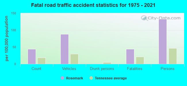
Rosemark fatal accident list:
FCC Registered Microwave Towers:
2- TIPTON, 18946 Highway 14 (Lat: 35.367361 Lon: -89.756028), Type: Mast, Structure height: 70.1 m, Overall height: 71.6 m, Call Sign: WMM388,
Assigned Frequencies: 6226.89 MHz, 6375.14 MHz, Grant Date: 01/25/2011, Expiration Date: 02/01/2021, Cancellation Date: 09/04/2019, Certifier: Gregory M Romano, Registrant: Verizon Wireless, 5055 North Point Pkwy, Np2ne Network Engineering, Alpharetta, GA 30022, Phone: (770) 797-1070, Email:
- ROSEMARK, 8946 Austin Peay (Lat: 35.367361 Lon: -89.756028), Type: Gtower, Structure height: 70.1 m, Overall height: 72.2 m, Call Sign: WQQW541,
Assigned Frequencies: 11545.0 MHz, 11585.0 MHz, 11625.0 MHz, 11665.0 MHz, 11305.0 MHz, 11055.0 MHz, Grant Date: 02/07/2023, Expiration Date: 03/15/2033, Certifier: John E Monday, Registrant: At&t Services, Inc., 208 S Akard St, 20f, Dallas, TX 75202, Phone: (855) 699-7073, Email:
FAA Registered Aircraft:
1- Aircraft: CESSNA 170B (Category: Land, Seats: 4, Weight: Up to 12,499 Pounds, Speed: 105 mph), Engine: CONT MOTOR C145 SERIES (145 HP) (Reciprocating)
N-Number: 4641C, N4641C, N-4641C, Serial Number: 25585, Year manufactured: 1953, Airworthiness Date: 09/30/1955, Certificate Issue Date: 06/11/2014
Registrant (Individual): Kevin B Kirchoff, 10517 Moose Rd, Rosemark, TN 38053
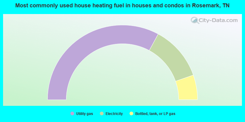
- 65.8%Utility gas
- 23.5%Electricity
- 10.7%Bottled, tank, or LP gas
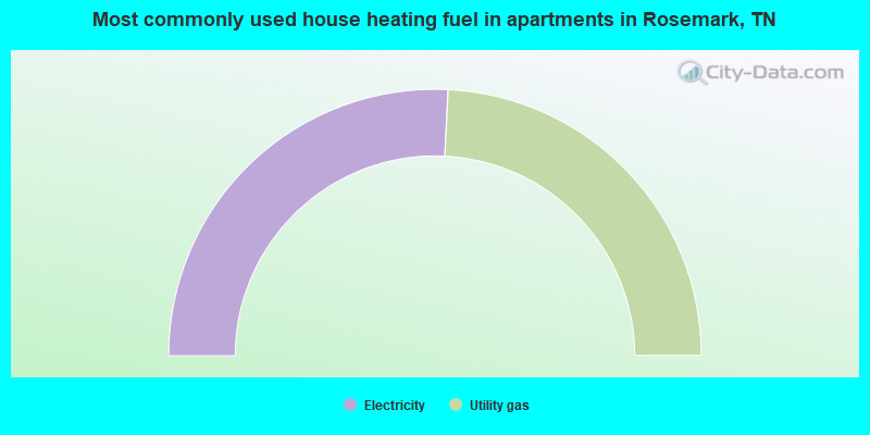
- 51.6%Electricity
- 48.4%Utility gas
Rosemark compared to Tennessee state average:
- Median household income above state average.
- Median house value above state average.
- Unemployed percentage significantly below state average.
- Hispanic race population percentage significantly below state average.
- Median age above state average.
- Foreign-born population percentage significantly below state average.
- Renting percentage significantly below state average.
- Length of stay since moving in significantly above state average.
- Number of rooms per house significantly below state average.
- House age significantly below state average.