Rocky Boy's, Montana
Submit your own pictures of this place and show them to the world
- OSM Map
- General Map
- Google Map
- MSN Map

| Males: 1,023 | |
| Females: 1,006 |
| Median resident age: | 22.9 years |
| Montana median age: | 37.5 years |
Zip code: 59521
| Rocky Boy's: | $54,077 |
| MT: | $67,631 |
Estimated per capita income in 2022: $16,860 (it was $8,879 in 2000)
Rocky Boy's CCD income, earnings, and wages data
Estimated median house or condo value in 2022: $108,670 (it was $36,900 in 2000)
| Rocky Boy's: | $108,670 |
| MT: | $366,400 |
Detailed information about poverty and poor residents in Rocky Boy's, MT


- 1,80388.1%American Indian alone
- 1879.1%White alone
- 301.5%Hispanic
- 211.0%Two or more races
- 20.10%Black alone
- 20.10%Asian alone
- 10.05%Native Hawaiian and Other
Pacific Islander alone

Races in Rocky Boy's detailed stats: ancestries, foreign born residents, place of birth
 Recent articles from our blog. Our writers, many of them Ph.D. graduates or candidates, create easy-to-read articles on a wide variety of topics.
Current Local Time: MST time zone
Land area: 222.7 square miles.
Population density: 9.1 people per square mile (very low).

| Rocky Boy's CCD: | 1.5% ($542) |
| Montana: | 1.3% ($1,212) |
Nearest city with pop. 50,000+: Great Falls, MT  (87.6 miles , pop. 56,690).
Nearest city with pop. 200,000+: East Seattle, WA (571.7 miles , pop. 480,100).
Nearest city with pop. 1,000,000+: Phoenix, AZ (1030.1 miles , pop. 1,321,045).
Nearest cities:
), ), ), ), ), ), )Latitude: 48.33 N, Longitude: 109.85 W
Area code commonly used in this area: 406

| Here: | 3.2% |
| Montana: | 3.8% |

- Educational services (25.0%)
- Public administration (20.9%)
- Health care (8.7%)
- Agriculture, forestry, fishing & hunting (7.1%)
- Construction (6.8%)
- Accommodation & food services (5.4%)
- Social assistance (4.4%)

- Public administration (23.9%)
- Educational services (13.4%)
- Construction (12.2%)
- Agriculture, forestry, fishing & hunting (9.6%)
- Health care (6.6%)
- Arts, entertainment, recreation (3.6%)
- Social assistance (3.3%)

- Educational services (39.3%)
- Public administration (17.3%)
- Health care (11.4%)
- Accommodation & food services (9.6%)
- Social assistance (5.9%)
- Agriculture, forestry, fishing & hunting (4.0%)
- Arts, entertainment, recreation (4.0%)

- Building and grounds cleaning and maintenance occupations (8.7%)
- Other management occupations, except farmers and farm managers (7.2%)
- Other teachers, instructors, education, training, and library occupations (5.9%)
- Other office and administrative support workers, including supervisors (5.6%)
- Preschool, kindergarten, elementary, and middle school teachers (5.3%)
- Supervisors and other personal care and service workers, except child care workers (3.3%)
- Farmers and farm managers (3.0%)

- Building and grounds cleaning and maintenance occupations (13.1%)
- Other management occupations, except farmers and farm managers (5.7%)
- Construction laborers (5.4%)
- Law enforcement workers, including supervisors (4.8%)
- Farmers and farm managers (4.5%)
- Carpenters (3.9%)
- Driver/sales workers and truck drivers (3.9%)

- Preschool, kindergarten, elementary, and middle school teachers (11.0%)
- Other teachers, instructors, education, training, and library occupations (11.0%)
- Other management occupations, except farmers and farm managers (9.2%)
- Other office and administrative support workers, including supervisors (8.5%)
- Child care workers (5.1%)
- Financial managers (4.0%)
- Secretaries and administrative assistants (3.3%)
Average climate in Rocky Boy's, Montana
Based on data reported by over 4,000 weather stations


Earthquake activity:
Rocky Boy's-area historical earthquake activity is significantly above Montana state average. It is 464% greater than the overall U.S. average.On 8/18/1959 at 06:37:13, a magnitude 7.7 (7.7 UK, Class: Major, Intensity: VIII - XII) earthquake occurred 263.0 miles away from the city center, causing $26,000,000 total damage
On 10/28/1983 at 14:06:06, a magnitude 7.3 (6.2 MB, 7.3 MS, 7.0 MW) earthquake occurred 349.5 miles away from Rocky Boy's center, causing 2 deaths (2 shaking deaths) and 3 injuries, causing $15,000,000 total damage
On 7/6/2017 at 06:30:17, a magnitude 5.8 (5.8 MW, Depth: 7.6 mi, Class: Moderate, Intensity: VI - VII) earthquake occurred 161.7 miles away from Rocky Boy's center
On 6/30/1975 at 18:54:13, a magnitude 6.1 (5.6 MB, 5.9 MS, 6.1 UK, 6.1 ML, Class: Strong, Intensity: VII - IX) earthquake occurred 256.3 miles away from the city center
On 3/31/2020 at 23:52:30, a magnitude 6.5 (6.5 MW, Depth: 7.5 mi) earthquake occurred 366.6 miles away from the city center
On 7/26/2005 at 04:08:37, a magnitude 5.7 (5.7 MB, 5.2 MS, 5.6 MW) earthquake occurred 240.1 miles away from the city center
Magnitude types: body-wave magnitude (MB), local magnitude (ML), surface-wave magnitude (MS), moment magnitude (MW)
Natural disasters:
The number of natural disasters in Hill County (10) is smaller than the US average (15).Major Disasters (Presidential) Declared: 7
Emergencies Declared: 1
Causes of natural disasters: Floods: 7, Storms: 4, Fire: 1, Hurricane: 1, Other: 1 (Note: some incidents may be assigned to more than one category).
Colleges/universities with over 2000 students nearest to Rocky Boy's:
- Montana State University-Billings (about 186 miles; Billings, MT; Full-time enrollment: 4,319)
- Montana State University (about 193 miles; Bozeman, MT; FT enrollment: 12,942)
- The University of Montana (about 218 miles; Missoula, MT; FT enrollment: 13,602)
- Sheridan College (about 283 miles; Sheridan, WY; FT enrollment: 2,070)
- North Idaho College (about 325 miles; Coeur d'Alene, ID; FT enrollment: 4,684)
- Brigham Young University-Idaho (about 326 miles; Rexburg, ID; FT enrollment: 30,522)
- Spokane Community College (about 351 miles; Spokane, WA; FT enrollment: 6,482)
Points of interest:
Notable locations in Rocky Boy's: Champagne Ranch (A), General Mills Incorporated Elevator (B), Box Elder (C), Bear Paw Ski Bowl (D), Beaver Creek Park Campground (E), Box Elder Rural Fire District (F). Display/hide their locations on the map
Churches in Rocky Boy's include: Saint Mary Church (A), Our Savior Lutheran Church (B), Saint Anthony Church (C). Display/hide their locations on the map
Cemetery: Rocky Boy Gravel (1). Display/hide its location on the map
Lakes and reservoirs: Amisk Pond (A), Grass Reservoir (B), Schmidt Reservoir (C), East Fork Beaver Creek Reservoir (D). Display/hide their locations on the map
Creeks: Boxelder Creek (A), Cabin Creek (B), Daychild Creek (C), Elk Creek (D), East Fork Beaver Creek (E), West Fork Beaver Creek (F), Otayachinas Creek (G), Small Boy Creek (H), Rocky Hock Creek (I). Display/hide their locations on the map
Parks in Rocky Boy's include: Beaver Creek Park (1), Rocky Boy Recreation Area (2). Display/hide their locations on the map
| This place: | 3.8 people |
| Montana: | 2.4 people |
| This place: | 87.4% |
| Whole state: | 62.8% |
| This place: | 10.1% |
| Whole state: | 6.7% |
Likely homosexual households (counted as self-reported same-sex unmarried-partner households)
- Lesbian couples: 1.0% of all households
- Gay men: 0.5% of all households
| This place: | 32.6% |
| Whole state: | 14.6% |
| This place: | 12.9% |
| Whole state: | 5.8% |
For population 15 years and over in Rocky Boy's:

- Never married: 32.2%
- Now married: 52.5%
- Separated: 2.3%
- Widowed: 4.9%
- Divorced: 10.4%
For population 25 years and over in Rocky Boy's:
- High school or higher: 79.0%
- Bachelor's degree or higher: 16.4%
- Graduate or professional degree: 6.1%
- Unemployed: 26.2%
- Mean travel time to work (commute): 16.7 minutes


| Here: | 11.8 |
| Montana average: | 10.4 |
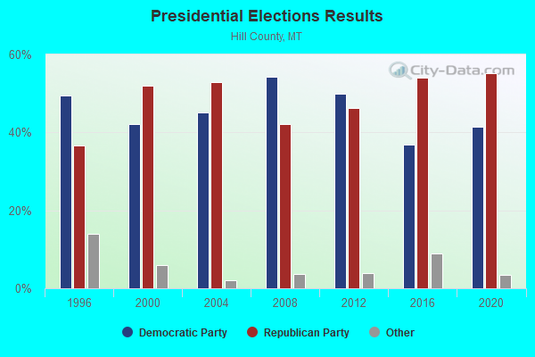
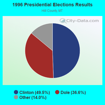
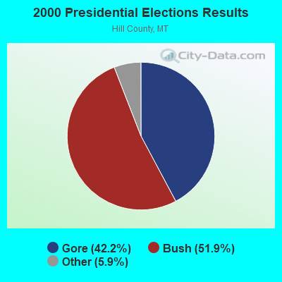
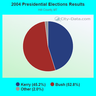
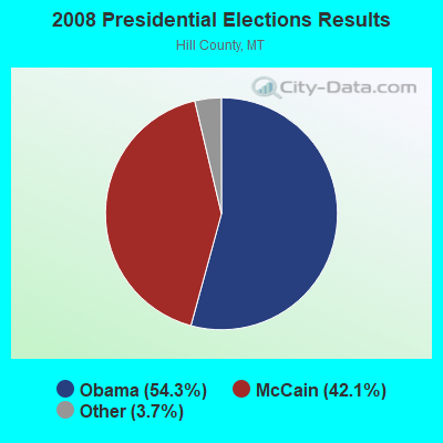
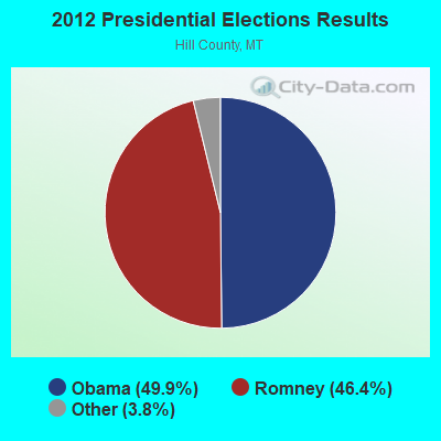
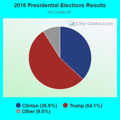
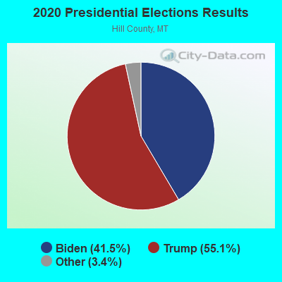
Graphs represent county-level data. Detailed 2008 Election Results
Religion statistics for Rocky Boy's, MT (based on Hill County data)
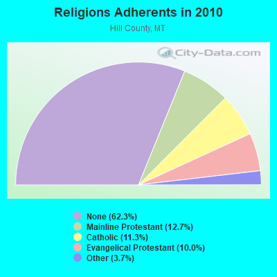
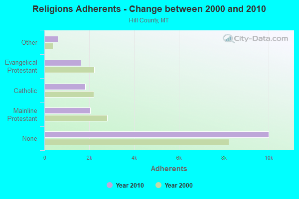
| Religion | Adherents | Congregations |
|---|---|---|
| Mainline Protestant | 2,039 | 14 |
| Catholic | 1,820 | 5 |
| Evangelical Protestant | 1,615 | 18 |
| Other | 601 | 2 |
| None | 10,021 | - |
Food Environment Statistics:
| This county: | 1.21 / 10,000 pop. |
| Montana: | 2.55 / 10,000 pop. |
| Hill County: | 0.60 / 10,000 pop. |
| Montana: | 0.48 / 10,000 pop. |
| Hill County: | 4.84 / 10,000 pop. |
| Montana: | 4.69 / 10,000 pop. |
| This county: | 6.65 / 10,000 pop. |
| State: | 10.38 / 10,000 pop. |
| This county: | 8.1% |
| Montana: | 7.2% |
| Hill County: | 29.0% |
| State: | 23.1% |
| Here: | 18.8% |
| State: | 10.7% |
Strongest AM radio stations in Rocky Boy's:
- KOJM (610 AM; 1 kW; HAVRE, MT; Owner: NEW MEDIA BROADCASTERS, INC.)
- KERR (750 AM; 50 kW; POLSON, MT; Owner: ANDERSON RADIO BROADCASTING, INC.)
- KOFI (1180 AM; 50 kW; KALISPELL, MT; Owner: KOFI, INC.)
- KSEN (1150 AM; 10 kW; SHELBY, MT; Owner: CAPSTAR TX LIMITED PARTNERSHIP)
- KMON (560 AM; 5 kW; GREAT FALLS, MT; Owner: COMMONWEALTH LICENSE SUBSIDIARY, LLC)
- KEIN (1310 AM; 5 kW; GREAT FALLS, MT; Owner: MUNSON RADIO, INC.)
- KGVW (640 AM; 10 kW; BELGRADE, MT; Owner: GALLATIN VALLEY WITNESS, INC.)
- KXMR (710 AM; 50 kW; BISMARCK, ND; Owner: RADIO BISMARCK MANDAN, LLC)
- KBOI (670 AM; 50 kW; BOISE, ID; Owner: CITADEL BROADCASTING COMPANY)
- KTBI (810 AM; daytime; 50 kW; EPHRATA, WA; Owner: TACOMA BROADCASTERS, INCORPORATED)
- KKGR (680 AM; daytime; 5 kW; EAST HELENA, MT; Owner: KKGR, INC.)
- KTWO (1030 AM; 50 kW; CASPER, WY; Owner: CITICASTERS LICENSES, L.P.)
- KGA (1510 AM; 50 kW; SPOKANE, WA; Owner: CITADEL BROADCASTING COMPANY)
Strongest FM radio stations in Rocky Boy's:
- KNMC (90.1 FM; HAVRE, MT; Owner: NORTHERN MONTANA COLLEGE)
- KXEI (95.1 FM; HAVRE, MT; Owner: HI-LINE RADIO FELLOWSHIP, INC.)
- KPQX (92.5 FM; HAVRE, MT; Owner: NEW MEDIA BROADCASTERS, INC.)
- K261CC (100.1 FM; CHESTER, MT; Owner: RANDALL D. ROCKS)
- KEHT (100.3 FM; GREAT FALLS, MT; Owner: GEORGE S. FLINN, JR.)
- KRYK (101.3 FM; CHINOOK, MT; Owner: NEW MEDIA BROADCASTERS, INC)
TV broadcast stations around Rocky Boy's:
- KBBJ (Channel 9; HAVRE, MT; Owner: SUNBELT COMMUNICATIONS COMPANY)
- K52CI (Channel 52; HAVRE, MT; Owner: CONTINENTAL TELEVISION NETWORK, INC.)
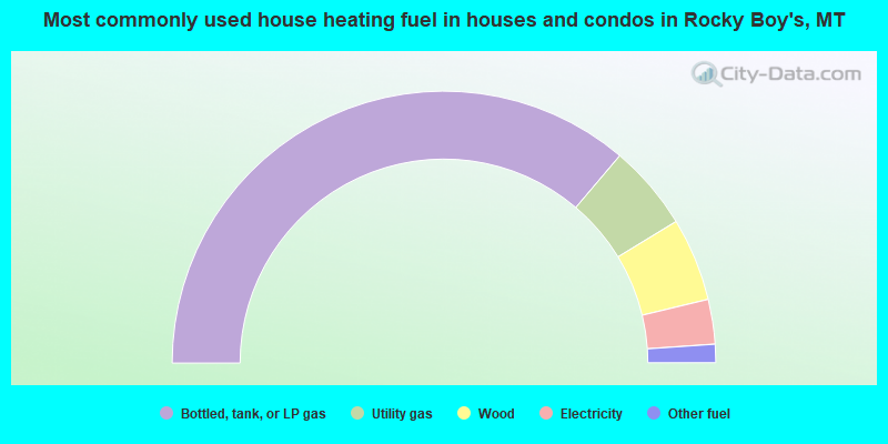
- 72.4%Bottled, tank, or LP gas
- 10.2%Utility gas
- 9.9%Wood
- 5.3%Electricity
- 2.2%Other fuel
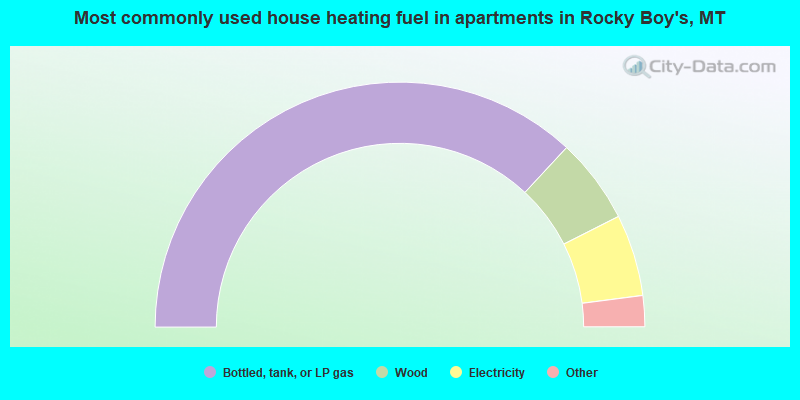
- 73.9%Bottled, tank, or LP gas
- 11.3%Wood
- 10.8%Electricity
- 3.2%Utility gas
- 0.9%Other fuel
Rocky Boy's compared to Montana state average:
- Median house value significantly below state average.
- Unemployed percentage above state average.
- Black race population percentage significantly below state average.
- Hispanic race population percentage significantly below state average.
- Median age significantly below state average.
- Foreign-born population percentage significantly below state average.
- Length of stay since moving in significantly above state average.
- Number of rooms per house significantly below state average.
- House age significantly below state average.