Rindge, New Hampshire
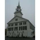
Rindge: Rindge Town Hall-Town Center
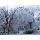
Rindge: Town Office
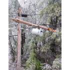
Rindge: Town Office
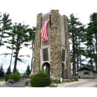
Rindge: Bell Tower, Cathedral of the Pines, Rindge NH
Rindge: Town Office
- add
your
Submit your own pictures of this town and show them to the world
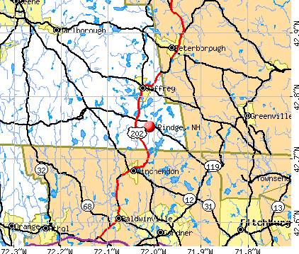
- OSM Map
- General Map
- Google Map
- MSN Map
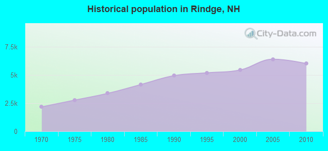
Population change since 2000: +10.3%
 |
| Males: 3,056 | |
| Females: 2,958 |
| Median resident age: | 29.7 years |
| New Hampshire median age: | 43.9 years |
Zip codes: 03461.
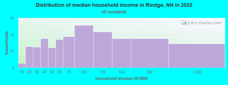
| Rindge: | $92,640 |
| NH: | $89,992 |
Estimated per capita income in 2022: $37,213 (it was $18,495 in 2000)
Rindge town income, earnings, and wages data
Estimated median house or condo value in 2022: $293,276 (it was $113,200 in 2000)
| Rindge: | $293,276 |
| NH: | $384,700 |
Mean prices in 2022: all housing units: $286,446; detached houses: $308,243; townhouses or other attached units: $255,194; in 2-unit structures: $255,554; in 3-to-4-unit structures: $346,438; in 5-or-more-unit structures: $233,006; mobile homes: $69,259
Detailed information about poverty and poor residents in Rindge, NH


- 5,69994.8%White alone
- 901.5%Two or more races
- 771.3%Hispanic
- 731.2%Black alone
- 540.9%Asian alone
- 130.2%Other race alone
- 80.1%American Indian alone
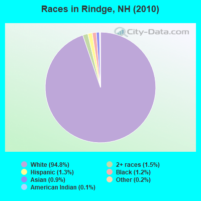
Races in Rindge detailed stats: ancestries, foreign born residents, place of birth
Type |
2009 |
2010 |
2011 |
2012 |
2013 |
2014 |
2015 |
2016 |
2017 |
2018 |
2019 |
2020 |
2021 |
2022 |
|---|---|---|---|---|---|---|---|---|---|---|---|---|---|---|
| Murders (per 100,000) | 0 (0.0) | 0 (0.0) | 0 (0.0) | 0 (0.0) | 0 (0.0) | 0 (0.0) | 0 (0.0) | 0 (0.0) | 0 (0.0) | 0 (0.0) | 0 (0.0) | 0 (0.0) | 0 (0.0) | 0 (0.0) |
| Rapes (per 100,000) | 2 (30.0) | 1 (16.6) | 1 (16.6) | 2 (33.3) | 4 (66.7) | 4 (68.2) | 3 (50.5) | 1 (17.2) | 2 (34.0) | 1 (16.0) | 5 (79.3) | 2 (32.8) | 1 (16.3) | 1 (15.1) |
| Robberies (per 100,000) | 0 (0.0) | 2 (33.3) | 2 (33.2) | 1 (16.6) | 0 (0.0) | 0 (0.0) | 1 (16.8) | 1 (17.2) | 0 (0.0) | 2 (32.1) | 0 (0.0) | 1 (16.4) | 1 (16.3) | 0 (0.0) |
| Assaults (per 100,000) | 4 (60.0) | 5 (83.1) | 3 (49.8) | 5 (83.2) | 4 (66.7) | 2 (34.1) | 4 (67.3) | 2 (34.4) | 4 (68.0) | 1 (16.0) | 7 (111.0) | 0 (0.0) | 0 (0.0) | 1 (15.1) |
| Burglaries (per 100,000) | 16 (239.9) | 26 (432.3) | 19 (315.5) | 12 (199.6) | 7 (116.7) | 14 (238.7) | 17 (286.1) | 9 (154.6) | 13 (221.0) | 10 (160.4) | 8 (126.8) | 4 (65.6) | 4 (65.1) | 5 (75.4) |
| Thefts (per 100,000) | 98 (1,469) | 40 (665.1) | 60 (996.3) | 45 (748.6) | 113 (1,884) | 77 (1,313) | 86 (1,447) | 69 (1,185) | 46 (781.9) | 55 (882.1) | 48 (760.9) | 41 (672.1) | 34 (553.6) | 26 (392.0) |
| Auto thefts (per 100,000) | 3 (45.0) | 4 (66.5) | 2 (33.2) | 3 (49.9) | 1 (16.7) | 1 (17.1) | 2 (33.7) | 2 (34.4) | 2 (34.0) | 2 (32.1) | 4 (63.4) | 2 (32.8) | 2 (32.6) | 1 (15.1) |
| Arson (per 100,000) | 4 (60.0) | 1 (16.6) | 0 (0.0) | 0 (0.0) | 0 (0.0) | 2 (34.1) | 0 (0.0) | 0 (0.0) | 0 (0.0) | 6 (96.2) | 14 (221.9) | 25 (409.8) | 30 (488.4) | 13 (196.0) |
| City-Data.com crime index | 115.2 | 102.1 | 97.8 | 96.2 | 151.6 | 132.0 | 139.5 | 86.7 | 90.3 | 74.7 | 130.0 | 65.2 | 47.2 | 37.2 |
The City-Data.com crime index weighs serious crimes and violent crimes more heavily. Higher means more crime, U.S. average is 246.1. It adjusts for the number of visitors and daily workers commuting into cities.
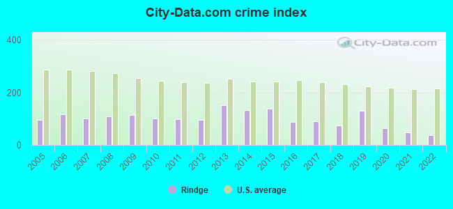
Crime rate in Rindge detailed stats: murders, rapes, robberies, assaults, burglaries, thefts, arson
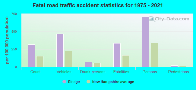
Full-time law enforcement employees in 2021, including police officers: 10 (9 officers - 8 male; 1 female).
| Officers per 1,000 residents here: | 1.47 |
| New Hampshire average: | 2.14 |
 Recent articles from our blog. Our writers, many of them Ph.D. graduates or candidates, create easy-to-read articles on a wide variety of topics.

 | Dover: hilly hikes? (18 replies) |
| antiques restoration in NH ? (3 replies) |
| More States Trying to Eliminate Income Tax (9 replies) |
| Thinking About Southern NH (11 replies) |
| New Hampshire (Cheshire Country) - WHAT THE HELL??? (21 replies) |
| Scott Brown and Andy Sanborn scheduled to appear at Rindge, NH Meeting House Aug 4th (36 replies) |
Latest news from Rindge, NH collected exclusively by city-data.com from local newspapers, TV, and radio stations
Ancestries: English (17.3%), Irish (12.4%), French (10.3%), Italian (8.3%), French Canadian (7.8%), United States (6.8%).
Current Local Time: EST time zone
Incorporated in 1768
Elevation: 1207 feet
Land area: 37.2 square miles.
Population density: 162 people per square mile (very low).
154 residents are foreign born (1.4% Europe, 1.2% North America).
| This town: | 2.8% |
| New Hampshire: | 4.4% |
| Rindge town: | 2.3% ($2,563) |
| New Hampshire: | 2.3% ($2,946) |
Nearest city with pop. 50,000+: Nashua, NH  (26.9 miles , pop. 86,605).
Nearest city with pop. 200,000+: Boston, MA (55.5 miles , pop. 589,141).
Nearest city with pop. 1,000,000+: Bronx, NY (162.9 miles , pop. 1,332,650).
Nearest cities:
), )Latitude: 42.75 N, Longitude: 72.01 W
Area code: 603

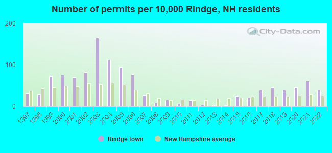
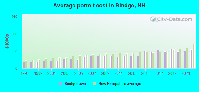
Single-family new house construction building permits:
- 2022: 22 buildings, average cost: $277,400
- 2021: 34 buildings, average cost: $259,200
- 2020: 25 buildings, average cost: $248,200
- 2019: 22 buildings, average cost: $282,200
- 2018: 25 buildings, average cost: $249,800
- 2017: 22 buildings, average cost: $267,800
- 2016: 11 buildings, average cost: $246,000
- 2015: 13 buildings, average cost: $257,200
- 2014: 1 building, cost: $184,000
- 2013: 1 building, cost: $184,000
- 2012: 2 buildings, average cost: $184,000
- 2011: 7 buildings, average cost: $168,900
- 2010: 3 buildings, average cost: $178,900
- 2009: 8 buildings, average cost: $180,600
- 2008: 5 buildings, average cost: $181,700
- 2007: 14 buildings, average cost: $178,300
- 2006: 42 buildings, average cost: $164,100
- 2005: 51 buildings, average cost: $129,500
- 2004: 61 buildings, average cost: $139,500
- 2003: 90 buildings, average cost: $132,800
- 2002: 44 buildings, average cost: $109,500
- 2001: 38 buildings, average cost: $109,300
- 2000: 41 buildings, average cost: $110,400
- 1999: 40 buildings, average cost: $100,000
- 1998: 16 buildings, average cost: $91,700
- 1997: 17 buildings, average cost: $91,700
| Here: | 3.9% |
| New Hampshire: | 2.5% |
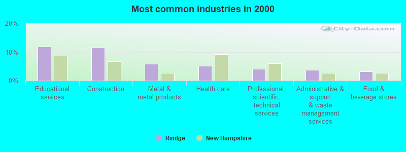
- Educational services (11.9%)
- Construction (11.7%)
- Metal & metal products (5.9%)
- Health care (5.1%)
- Professional, scientific, technical services (4.1%)
- Administrative & support & waste management services (3.8%)
- Food & beverage stores (3.1%)
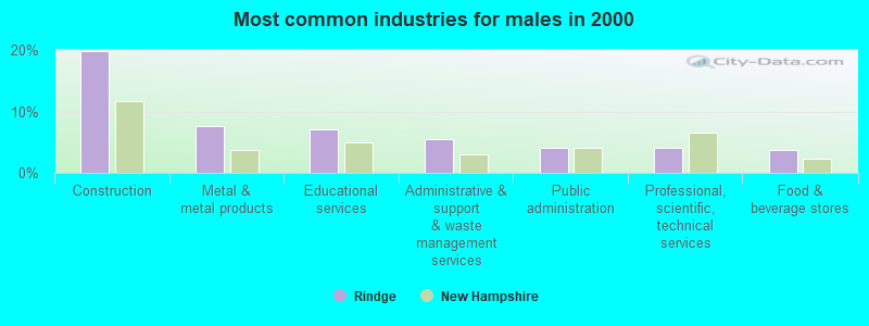
- Construction (19.8%)
- Metal & metal products (7.7%)
- Educational services (7.0%)
- Administrative & support & waste management services (5.5%)
- Public administration (4.2%)
- Professional, scientific, technical services (4.1%)
- Food & beverage stores (3.7%)
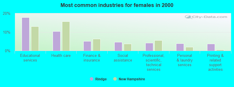
- Educational services (17.8%)
- Health care (10.3%)
- Finance & insurance (5.1%)
- Social assistance (4.6%)
- Professional, scientific, technical services (4.2%)
- Personal & laundry services (3.8%)
- Printing & related support activities (3.7%)
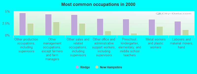
- Other production occupations, including supervisors (4.7%)
- Other management occupations, except farmers and farm managers (4.4%)
- Other sales and related occupations, including supervisors (4.3%)
- Other office and administrative support workers, including supervisors (3.5%)
- Preschool, kindergarten, elementary, and middle school teachers (3.4%)
- Metal workers and plastic workers (3.3%)
- Laborers and material movers, hand (2.9%)
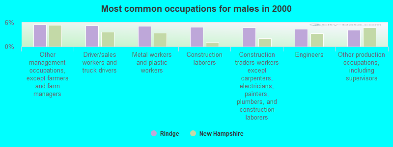
- Other management occupations, except farmers and farm managers (5.5%)
- Driver/sales workers and truck drivers (5.3%)
- Metal workers and plastic workers (5.2%)
- Construction laborers (4.9%)
- Construction traders workers except carpenters, electricians, painters, plumbers, and construction laborers (4.7%)
- Engineers (4.4%)
- Other production occupations, including supervisors (4.2%)
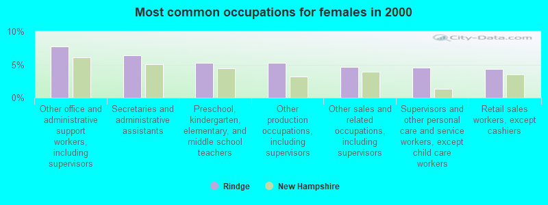
- Other office and administrative support workers, including supervisors (7.7%)
- Secretaries and administrative assistants (6.3%)
- Preschool, kindergarten, elementary, and middle school teachers (5.3%)
- Other production occupations, including supervisors (5.3%)
- Other sales and related occupations, including supervisors (4.6%)
- Supervisors and other personal care and service workers, except child care workers (4.5%)
- Retail sales workers, except cashiers (4.3%)
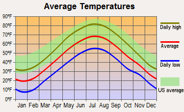
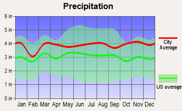
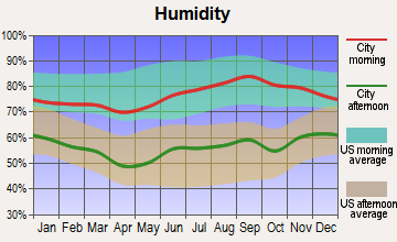
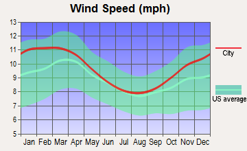
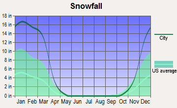
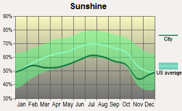
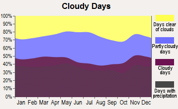
Average climate in Rindge, New Hampshire
Based on data reported by over 4,000 weather stations
(lower is better)
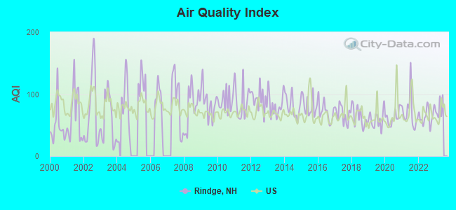
Air Quality Index (AQI) level in 2022 was 64.4. This is about average.
| City: | 64.4 |
| U.S.: | 72.6 |
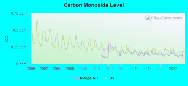
Carbon Monoxide (CO) [ppm] level in 2022 was 0.131. This is significantly better than average. Closest monitor was 10.2 miles away from the city center.
| City: | 0.131 |
| U.S.: | 0.251 |
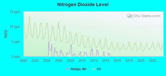
Nitrogen Dioxide (NO2) [ppb] level in 2008 was 1.69. This is significantly better than average. Closest monitor was 10.2 miles away from the city center.
| City: | 1.69 |
| U.S.: | 5.11 |
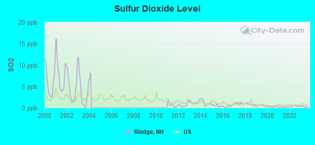
Sulfur Dioxide (SO2) [ppb] level in 2022 was 0.411. This is significantly better than average. Closest monitor was 10.2 miles away from the city center.
| City: | 0.411 |
| U.S.: | 1.515 |
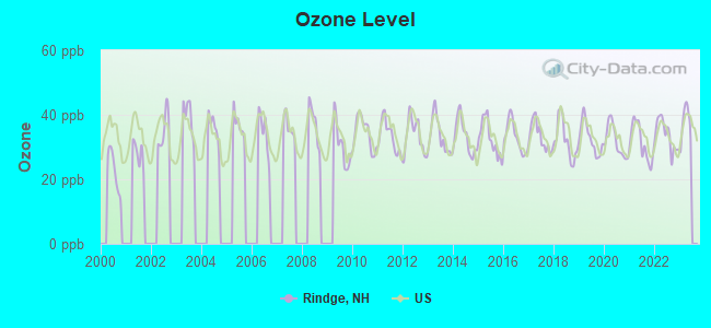
Ozone [ppb] level in 2022 was 33.7. This is about average. Closest monitor was 10.2 miles away from the city center.
| City: | 33.7 |
| U.S.: | 33.3 |
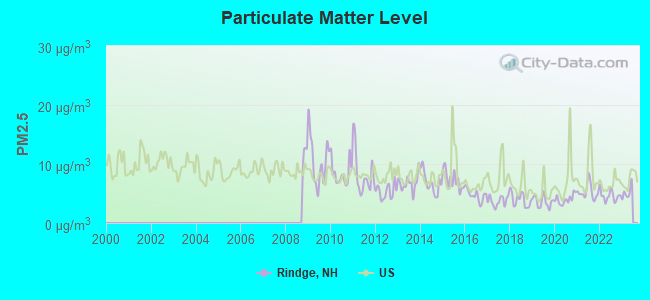
Particulate Matter (PM2.5) [µg/m3] level in 2022 was 4.62. This is significantly better than average. Closest monitor was 10.2 miles away from the city center.
| City: | 4.62 |
| U.S.: | 8.11 |
Tornado activity:
Rindge-area historical tornado activity is above New Hampshire state average. It is 20% smaller than the overall U.S. average.
On 6/9/1953, a category F4 (max. wind speeds 207-260 mph) tornado 21.0 miles away from the Rindge town center killed 90 people and injured 1228 people and caused between $50,000,000 and $500,000,000 in damages.
On 6/22/1981, a category F3 (max. wind speeds 158-206 mph) tornado 14.9 miles away from the town center injured 3 people and caused between $5000 and $50,000 in damages.
Earthquake activity:
Rindge-area historical earthquake activity is significantly above New Hampshire state average. It is 71% smaller than the overall U.S. average.On 10/7/1983 at 10:18:46, a magnitude 5.3 (5.1 MB, 5.3 LG, 5.1 ML, Class: Moderate, Intensity: VI - VII) earthquake occurred 143.8 miles away from Rindge center
On 4/20/2002 at 10:50:47, a magnitude 5.3 (5.3 ML, Depth: 3.0 mi) earthquake occurred 148.3 miles away from the city center
On 4/20/2002 at 10:50:47, a magnitude 5.2 (5.2 MB, 4.2 MS, 5.2 MW, 5.0 MW) earthquake occurred 147.5 miles away from the city center
On 1/19/1982 at 00:14:42, a magnitude 4.7 (4.5 MB, 4.7 MD, 4.5 LG, Class: Light, Intensity: IV - V) earthquake occurred 55.9 miles away from Rindge center
On 10/16/2012 at 23:12:25, a magnitude 4.7 (4.7 ML, Depth: 10.0 mi) earthquake occurred 90.0 miles away from the city center
On 10/2/1994 at 11:27:22, a magnitude 3.7 (3.5 LG, 3.7 LG, Depth: 6.2 mi, Class: Light, Intensity: II - III) earthquake occurred 31.0 miles away from Rindge center
Magnitude types: regional Lg-wave magnitude (LG), body-wave magnitude (MB), duration magnitude (MD), local magnitude (ML), surface-wave magnitude (MS), moment magnitude (MW)
Natural disasters:
The number of natural disasters in Cheshire County (27) is a lot greater than the US average (15).Major Disasters (Presidential) Declared: 16
Emergencies Declared: 11
Causes of natural disasters: Floods: 11, Storms: 11, Snows: 4, Snowstorms: 3, Winter Storms: 3, Hurricanes: 2, Blizzard: 1, Heavy Rain: 1, Ice Storm: 1, Landslide: 1, Snowfall: 1, Tropical Storm: 1, Wind: 1, Other: 1 (Note: some incidents may be assigned to more than one category).
Hospitals and medical centers near Rindge:
- GOOD SHEPHERD REHABILITATION AND NURSING CENTER (Nursing Home, about 4 miles away; JAFFREY, NH)
- OPEN ARMS NURSING HOME INC (Nursing Home, about 6 miles away; WINCHENDON, MA)
- WACHUSETT MANOR NURSING HOME (Nursing Home, about 7 miles away; GARDNER, MA)
- NAUKEAG HOSPITAL CORPORATION (Hospital, about 8 miles away; ASHBURNHAM, MA)
- BALDWINVILLE NURSING HOME (Nursing Home, about 11 miles away; BALDWINVILLE, MA)
- MONADNOCK COMMUNITY HOSPITAL Critical Access Hospitals (about 11 miles away; PETERBOROUGH, NH)
- GARDNER VNA (Home Health Center, about 12 miles away; GARDNER, MA)
College/University in Rindge:
Other colleges/universities with over 2000 students near Rindge:
- Mount Wachusett Community College (about 11 miles; Gardner, MA; Full-time enrollment: 3,143)
- Fitchburg State University (about 16 miles; Fitchburg, MA; FT enrollment: 5,010)
- Keene State College (about 19 miles; Keene, NH; FT enrollment: 5,098)
- Saint Anselm College (about 31 miles; Manchester, NH; FT enrollment: 2,059)
- Mount Washington College (about 32 miles; Manchester, NH; FT enrollment: 2,187)
- Quinsigamond Community College (about 33 miles; Worcester, MA; FT enrollment: 5,877)
- Assumption College (about 33 miles; Worcester, MA; FT enrollment: 2,580)
Private high schools in Rindge:
- HERITAGE CHRISTIAN SCHOOL (Students: 78, Location: 13 NORTH ST, Grades: KG-10)
- HAMPSHIRE COUNTRY SCHOOL (Students: 22, Location: 28 PATEY CIR, Grades: 4-12, Boys only)
- THE MEETING SCHOOL (Students: 1, Location: 120 THOMAS RD, Grades: 12)
Public elementary/middle school in Rindge:
- RINDGE MEMORIAL SCHOOL (Students: 426, Location: 45 SCHOOL ST., Grades: PK-5)
Points of interest:
Notable locations in Rindge: Cathedral of the Pines (A), Woodemere Park Campground (B), Camp Quinapoxet (C), Christian Science Camp (D), Rindge Fire Department (E), Franklin Pierce University Emergency Medical Technician Squad (F). Display/hide their locations on the map
Church in Rindge: Advent Lutheran Church (A). Display/hide its location on the map
Cemeteries: Wilder Cemetery (1), Robbins Cemetery (2), Hillside Cemetery (3), Rand Cemetery (4). Display/hide their locations on the map
Lakes and reservoirs: Robbins Pond (A), Bancroft Reservoir (B), Bullet Pond (C), Converse Meadow Pond (D), Crowcroft Pond (E), Divol Pond (F), Emerson Pond (G), Grassy Pond (H). Display/hide their locations on the map
Streams, rivers, and creeks: Lord Brook (A). Display/hide its location on the map
Parks in Rindge include: Fosket Wildlife Refuge (1), Annett State Reservation (2). Display/hide their locations on the map
Birthplace of: Alfred C. Converse - March 17.
Drinking water stations with addresses in Rindge and their reported violations in the past:
FRANKLIN PIERCE UNIVERSITY (Population served: 1,600, Groundwater):Past monitoring violations:WOODMORE CAMPGROUND (Population served: 313, Groundwater):
- Failure To Address Deficiency - In DEC-16-2013, Contaminant: GROUNDWATER RULE. Follow-up actions: St Public Notif requested (DEC-31-2013), St Violation/Reminder Notice (DEC-31-2013), St Public Notif received (FEB-07-2014)
Past monitoring violations:RINDGE PIZZA HAVEN (Population served: 100, Groundwater):
- Failure To Address Deficiency - In SEP-18-2011, Contaminant: GROUNDWATER RULE. Follow-up actions: St Public Notif requested (SEP-30-2011), St Formal NOV issued (SEP-30-2011), St Compliance achieved (JAN-10-2012), St Public Notif received (MAR-06-2012)
- 2 routine major monitoring violations
- One regular monitoring violation
Past health violations:TOAH NIPI/RETREAT BETHEL (Population served: 88, Groundwater):Past monitoring violations:
- MCL, Monthly (TCR) - Between JUL-2010 and SEP-2010, Contaminant: Coliform. Follow-up actions: St Public Notif requested (AUG-05-2010), St Violation/Reminder Notice (AUG-05-2010), St Public Notif received (AUG-13-2010), St Formal NOV issued (AUG-27-2010), St Compliance achieved (APR-05-2011)
- MCL, Monthly (TCR) - Between APR-2010 and JUN-2010, Contaminant: Coliform. Follow-up actions: St Public Notif requested (JUN-29-2010), St Violation/Reminder Notice (JUN-29-2010), St Public Notif received (JUL-12-2010), St Formal NOV issued (AUG-27-2010), St Compliance achieved (APR-05-2011)
- MCL, Monthly (TCR) - Between APR-2006 and JUN-2006, Contaminant: Coliform. Follow-up actions: St Public Notif requested (JUL-18-2006), St Violation/Reminder Notice (JUL-18-2006), St Public Notif received (AUG-07-2006), St Compliance achieved (DEC-28-2006)
- 2 routine major monitoring violations
- One minor monitoring violation
Past monitoring violations:TOAH NIPI/RETREAT HEBRON (Population served: 62, Groundwater):
- One routine major monitoring violation
Past monitoring violations:WELLINGTON REC COMPLEX (Address: 115 MAIN ST , Population served: 25, Groundwater):
- One routine major monitoring violation
Past monitoring violations:
- 2 routine major monitoring violations
Drinking water stations with addresses in Rindge that have no violations reported:
- MONADNOCK TENANTS (Population served: 190, Primary Water Source Type: Groundwater)
- FOREST VIEW ESTATES (Population served: 70, Primary Water Source Type: Groundwater)
| This town: | 2.7 people |
| New Hampshire: | 2.5 people |
| This town: | 72.9% |
| Whole state: | 66.3% |
| This town: | 7.7% |
| Whole state: | 8.3% |
Likely homosexual households (counted as self-reported same-sex unmarried-partner households)
- Lesbian couples: 0.7% of all households
- Gay men: 0.3% of all households
| This town: | 7.6% |
| Whole state: | 6.5% |
| This town: | 1.8% |
| Whole state: | 2.8% |
18 people in workers' group living quarters and job corps centers in 2010
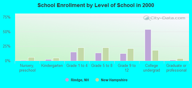
1,136 people in college dormitories (includes college quarters off campus) in 2000
9 people in unknown juvenile institutions in 2000
Banks with branches in Rindge (2011 data):
- TD Bank, National Association: Rindge Branch at Cheshire Market Place, Route 202, branch established on 1979/05/14. Info updated 2010/10/04: Bank assets: $188,912.6 mil, Deposits: $153,149.8 mil, headquarters in Wilmington, DE, positive income, 1314 total offices, Holding Company: Toronto-Dominion Bank, The
For population 15 years and over in Rindge:
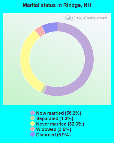
- Never married: 32.3%
- Now married: 56.2%
- Separated: 1.3%
- Widowed: 3.5%
- Divorced: 6.9%
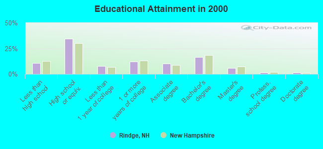
For population 25 years and over in Rindge:
- High school or higher: 89.5%
- Bachelor's degree or higher: 24.9%
- Graduate or professional degree: 8.6%
- Unemployed: 19.1%
- Mean travel time to work (commute): 26.5 minutes
| Here: | 9.6 |
| New Hampshire average: | 10.9 |
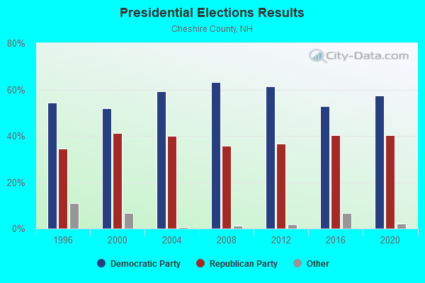
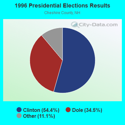
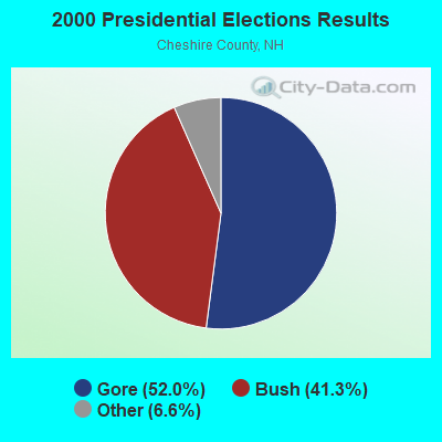
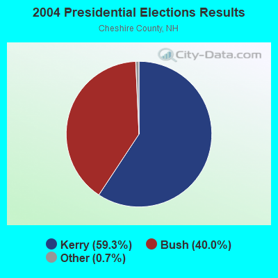

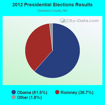
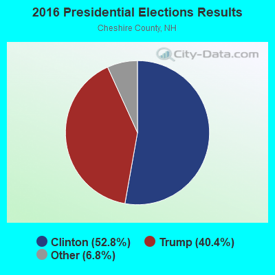
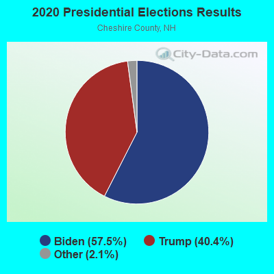
Graphs represent county-level data. Detailed 2008 Election Results
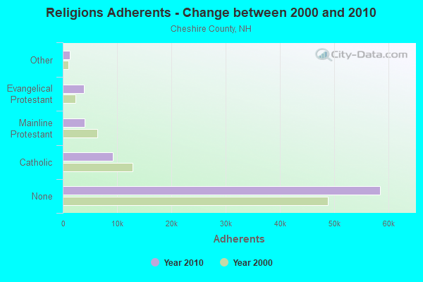
Religion statistics for Rindge, NH (based on Cheshire County data)
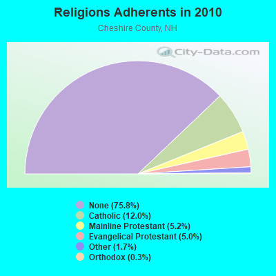
| Religion | Adherents | Congregations |
|---|---|---|
| Catholic | 9,237 | 9 |
| Mainline Protestant | 4,015 | 37 |
| Evangelical Protestant | 3,881 | 25 |
| Other | 1,292 | 13 |
| Orthodox | 250 | 1 |
| None | 58,442 | - |
Food Environment Statistics:
| Cheshire County: | 3.10 / 10,000 pop. |
| New Hampshire: | 2.14 / 10,000 pop. |
| Cheshire County: | 3.10 / 10,000 pop. |
| New Hampshire: | 1.78 / 10,000 pop. |
| This county: | 3.75 / 10,000 pop. |
| State: | 4.02 / 10,000 pop. |
| Cheshire County: | 8.67 / 10,000 pop. |
| New Hampshire: | 9.70 / 10,000 pop. |
| This county: | 8.2% |
| New Hampshire: | 7.6% |
| Here: | 27.5% |
| New Hampshire: | 24.4% |
| Cheshire County: | 14.5% |
| New Hampshire: | 15.9% |
| Businesses in Rindge, NH | ||||
| Name | Count | Name | Count | |
|---|---|---|---|---|
| Decora Cabinetry | 4 | Sears | 1 | |
| Dunkin Donuts | 2 | Subway | 1 | |
| FedEx | 1 | Taco Bell | 1 | |
| KFC | 1 | U-Haul | 1 | |
| MasterBrand Cabinets | 4 | Walmart | 1 | |
| Payless | 1 | |||
Strongest AM radio stations in Rindge:
- WCRN (830 AM; 50 kW; WORCESTER, MA; Owner: CARTER BROADCASTING CORPORATION)
- WRKO (680 AM; 50 kW; BOSTON, MA; Owner: ENTERCOM BOSTON LICENSE, LLC)
- WVNE (760 AM; daytime; 25 kW; LEICESTER, MA; Owner: BLOUNT MASSCOM, INC.)
- WNNZ (640 AM; 50 kW; WESTFIELD, MA; Owner: CLEAR CHANNEL BROADCASTING LICENSES, INC.)
- WEEI (850 AM; 50 kW; BOSTON, MA; Owner: ENTERCOM BOSTON LICENSE, LLC)
- WKOX (1200 AM; 50 kW; FRAMINGHAM, MA; Owner: CAPSTAR TX LIMITED PARTNERSHIP)
- WEIM (1280 AM; 5 kW; FITCHBURG, MA; Owner: LIVEAIR COMMUNICATIONS, INC.)
- WBIX (1060 AM; 40 kW; NATICK, MA; Owner: LANGER BROADCASTING CORPORATION)
- WWZN (1510 AM; 50 kW; BOSTON, MA; Owner: ROSE CITY RADIO CORPORATION)
- WALE (990 AM; 50 kW; GREENVILLE, RI; Owner: NORTH AMERICAN BROADCASTING CO., INC.)
- WAMG (890 AM; 25 kW; DEDHAM, MA; Owner: MEGA COMMUNICATIONS OF DEDHAM LICENSEE, LLC)
- WFGL (960 AM; 2 kW; FITCHBURG, MA; Owner: CSN INTERNATIONAL)
- WBZ (1030 AM; 50 kW; BOSTON, MA; Owner: INFINITY BROADCASTING OPERATIONS, INC.)
Strongest FM radio stations in Rindge:
- WINQ (97.7 FM; WINCHENDON, MA; Owner: SAGA COMMUNICATIONS OF NEW ENGLAND, LLC)
- WFEX (92.1 FM; PETERBOROUGH, NH; Owner: FNX BROADCASTING OF NEW HAMPSHIRE LLC)
- WHDQ (106.1 FM; CLAREMONT, NH; Owner: GREAT NORTHERN RADIO, L.L.C.)
- WXLO (104.5 FM; FITCHBURG, MA; Owner: CITADEL BROADCASTING COMPANY)
- WGIR-FM (101.1 FM; MANCHESTER, NH; Owner: CAPSTAR TX LIMITED PARTNERSHIP)
- WKNE (103.7 FM; KEENE, NH; Owner: SAGA COMMUNICATIONS OF NEW ENGLAND, LLC)
- WQLL (96.5 FM; BEDFORD, NH; Owner: SAGA COMMUNICATIONS OF NEW ENGLAND, LLC)
- WLMW (90.7 FM; MANCHESTER, NH; Owner: KNOWLEDGE FOR LIFE)
- WAHL (99.9 FM; ATHOL, MA; Owner: CITADEL BROADCASTING COMPANY)
- WEVN (90.7 FM; KEENE, NH; Owner: NEW HAMPSHIRE PUBLIC RADIO, INC.)
- WZID (95.7 FM; MANCHESTER, NH; Owner: SAGA COMMUNICATIONS OF NEW ENGLAND, LLC)
- WOQL (98.7 FM; WINCHESTER, NH; Owner: SAGA COMMUNICATIONS OF NEW HAMPSHIRE, LLC)
- WAAF (107.3 FM; WORCESTER, MA; Owner: ENTERCOM BOSTON LICENSE, LLC)
- WVPR (89.5 FM; WINDSOR, VT; Owner: VERMONT PUBLIC RADIO)
- WYRY (104.9 FM; HINSDALE, NH; Owner: TRI-VALLEY BROADCASTING CORPORATION)
- W293AB (106.5 FM; KEENE, NH; Owner: GREAT NORTHERN RADIO, L.L.C.)
- WEQX (102.7 FM; MANCHESTER, VT; Owner: NORTHSHIRE COMMUNICATIONS, INC.)
- WTPL (107.7 FM; HILLSBORO, NH; Owner: CONCORD BROADCASTING, L.L.C.)
- WJAN (95.1 FM; SUNDERLAND, VT; Owner: 6 JOHNSON ROAD LICENSES, INC.)
- WSRS (96.1 FM; WORCESTER, MA; Owner: CAPSTAR TX LIMITED PARTNERSHIP)
TV broadcast stations around Rindge:
- WUNI (Channel 27; WORCESTER, MA; Owner: ENTRAVISION HOLDINGS, LLC)
- WUTF (Channel 66; MARLBOROUGH, MA; Owner: TELEFUTURA BOSTON LLC)
- WCVB-TV (Channel 5; BOSTON, MA; Owner: WCVB HEARST-ARGYLE TV, INC.)
- WYDN (Channel 48; WORCESTER, MA; Owner: EDUCATIONAL PUBLIC TV CORPORATION)
- WMFP (Channel 62; LAWRENCE, MA; Owner: WSAH LICENSE, INC.)
- WBZ-TV (Channel 4; BOSTON, MA; Owner: VIACOM INC.)
- WGBX-TV (Channel 44; BOSTON, MA; Owner: WGBH EDUCATIONAL FOUNDATION)
- WEKW-TV (Channel 52; KEENE, NH; Owner: UNIVERSITY OF NEW HAMPSHIRE)
- National Bridge Inventory (NBI) Statistics
- 3Number of bridges
- 10ft / 2.8mTotal length
- $9,426,000Total costs
- 4,878Total average daily traffic
- 306Total average daily truck traffic
- 7,218Total future (year 2042) average daily traffic
FCC Registered Cell Phone Towers:
1 (See the full list of FCC Registered Cell Phone Towers in Rindge)FCC Registered Antenna Towers:
12 (See the full list of FCC Registered Antenna Towers)FCC Registered Broadcast Land Mobile Towers:
6- Fire Station Main St (Lat: 42.750917 Lon: -72.010361), Call Sign: KDL958,
Assigned Frequencies: 153.770 MHz, 154.430 MHz, Grant Date: 11/06/2021, Expiration Date: 01/16/2032, Registrant: Beltronics, Inc., 240 Main Dunstable Rd, Nashua, NH 03062, Phone: (603) 402-4144, Fax: (603) 386-6344, Email:
- Hwy Garage (Lat: 42.753694 Lon: -72.012861), Call Sign: KFP400,
Assigned Frequencies: 156.180 MHz, Grant Date: 12/06/2011, Expiration Date: 02/19/2022, Cancellation Date: 04/23/2022, Registrant: Business Radio Licensing, 26941 Cabot Road #134, Laguna Hills, CA 92653, Phone: (949) 348-8510, Fax: (949) 348-8514, Email:
- Franklin Pierce College (Lat: 42.757222 Lon: -72.020556), Type: Tank, Structure height: 12.2 m, Overall height: 14 m, Call Sign: KVT716,
Assigned Frequencies: 155.070 MHz, Grant Date: 08/03/2021, Expiration Date: 09/01/2031, Registrant: Cheshire County Sheriffs Office, 12 Court Street, Keene, NH 03431, Phone: (603) 352-4238, Fax: (603) 355-3020, Email:
- Town Office (Lat: 42.750083 Lon: -72.143972), Call Sign: KWX371,
Assigned Frequencies: 155.070 MHz, Grant Date: 02/24/2024, Expiration Date: 05/10/2034, Registrant: Rindge Police Department, 158 Main Street, Rindge, NH 03461-0007, Phone: (603) 899-5009, Fax: (603) 899-2103, Email:
- Squantum Rd (Lat: 42.780083 Lon: -71.981472), Type: Tank, Structure height: 9 m, Call Sign: WPGS540,
Assigned Frequencies: 173.312 MHz, Grant Date: 01/27/2015, Expiration Date: 03/09/2025, Registrant: Swnh District Fire Mutual Aid, 32 Vernon St., Keene, NH 03431, Phone: (603) 352-8635, Fax: (603) 357-1985, Email:
- Lat: 42.770833 Lon: -72.057444, Call Sign: WQJN737,
Assigned Frequencies: 154.505 MHz, Grant Date: 11/12/2008, Expiration Date: 11/12/2018, Cancellation Date: 02/16/2019, Certifier: Douglas Lear, Registrant: Radio Licensing Services, 4700 Se International Way, Milwaukie, OR 97269, Phone: (503) 794-3761, Fax: (503) 794-3759, Email:
FCC Registered Microwave Towers:
6- RINDGE/JAFFREY, 19 Jones Road (Lat: 42.756806 Lon: -72.019889), Type: Tower, Structure height: 57.9 m, Overall height: 59.4 m, Call Sign: WMT393,
Assigned Frequencies: 10557.5 MHz, Grant Date: 01/04/2011, Expiration Date: 02/01/2021, Cancellation Date: 04/10/2015, Registrant: Holland & Knight LLP, 800 17th Street, N.W., Suite #1100, Washington, DC 20006-3906, Phone: (202) 955-3000, Fax: (202) 955-5564, Email:
- Franklin Pierce, Franklin Pierce College Ollege Rd. (Lat: 42.780833 Lon: -72.057778), Type: Bant, Structure height: 18.2 m, Call Sign: WPTN208, Licensee ID: L00129200,
Assigned Frequencies: 11615.0 MHz, Grant Date: 11/05/2001, Expiration Date: 11/05/2011, Cancellation Date: 09/28/2010, Certifier: Michael J Shortley Iii, Registrant: Global Crossing Telecommunications, Inc.
- NH RIN JON, Lat: 42.757000 Lon: -72.020417, Type: Upole, Structure height: 23 m, Call Sign: WQJH296,
Assigned Frequencies: 3650.00 MHz, Grant Date: 11/07/2018, Expiration Date: 10/17/2020, Cancellation Date: 12/19/2020, Certifier: Brian R Foucher, Registrant: Business Radio Licensing, 30251 Golden Lantern, Suite E # 501, Laguna Niguel, CA 92677, Phone: (949) 348-8510, Fax: (949) 348-8514, Email:
- NH RIN STA, Lat: 42.719389 Lon: -71.990056, Type: Upole, Structure height: 15 m, Call Sign: WQJH296,
Assigned Frequencies: 3650.00 MHz, Grant Date: 11/07/2018, Expiration Date: 10/17/2020, Cancellation Date: 12/19/2020, Certifier: Brian R Foucher, Registrant: Business Radio Licensing, 30251 Golden Lantern, Suite E # 501, Laguna Niguel, CA 92677, Phone: (949) 348-8510, Fax: (949) 348-8514, Email:
- NH RIN MEA, Lat: 42.769639 Lon: -72.081194, Type: Ltower, Structure height: 24 m, Call Sign: WQJH296,
Assigned Frequencies: 3650.00 MHz, Grant Date: 11/07/2018, Expiration Date: 10/17/2020, Cancellation Date: 12/19/2020, Certifier: Brian R Foucher, Registrant: Business Radio Licensing, 30251 Golden Lantern, Suite E # 501, Laguna Niguel, CA 92677, Phone: (949) 348-8510, Fax: (949) 348-8514, Email:
- NH RIN CAT, Lat: 42.774750 Lon: -71.988556, Type: Pole, Structure height: 23 m, Call Sign: WQJH296,
Assigned Frequencies: 3650.00 MHz, Grant Date: 11/07/2018, Expiration Date: 10/17/2020, Cancellation Date: 12/19/2020, Certifier: Brian R Foucher, Registrant: Business Radio Licensing, 30251 Golden Lantern, Suite E # 501, Laguna Niguel, CA 92677, Phone: (949) 348-8510, Fax: (949) 348-8514, Email:
FCC Registered Amateur Radio Licenses:
70 (See the full list of FCC Registered Amateur Radio Licenses in Rindge)FAA Registered Aircraft:
13 (See the full list of FAA Registered Aircraft in Rindge)2002 - 2018 National Fire Incident Reporting System (NFIRS) incidents
- Fire incident types reported to NFIRS in Rindge, NH
- 26546.8%Structure Fires
- 16328.8%Outside Fires
- 8815.5%Other
- 508.8%Mobile Property/Vehicle Fires
 According to the data from the years 2002 - 2018 the average number of fires per year is 33. The highest number of fire incidents - 59 took place in 2008, and the least - 10 in 2007. The data has a growing trend.
 When looking into fire subcategories, the most reports belonged to: Structure Fires (46.8%), and Outside Fires (28.8%).
- 76.9%Fuel oil, kerosene, etc.
- 14.0%Wood
- 7.2%Bottled, tank, or LP gas
- 1.8%Electricity
- 82.2%Fuel oil, kerosene, etc.
- 11.2%Electricity
- 6.6%Bottled, tank, or LP gas
Rindge compared to New Hampshire state average:
- Hispanic race population percentage significantly below state average.
- Median age significantly below state average.
- Foreign-born population percentage below state average.
- Renting percentage below state average.
- Length of stay since moving in significantly above state average.
- Number of rooms per house significantly below state average.
- House age significantly below state average.
- Number of college students significantly above state average.
Rindge on our top lists:
- #5 on the list of "Top 101 cities with largest percentage of males in industries: petroleum and petroleum products merchant wholesalers (population 5,000+)"
- #8 on the list of "Top 101 cities with largest percentage of females in industries: printing and related support activities (population 5,000+)"
- #13 on the list of "Top 101 cities with largest percentage of females in occupations: printing workers (population 5,000+)"
- #14 on the list of "Top 101 cities with largest percentage of females in industries: book stores and news dealers (population 5,000+)"
- #23 on the list of "Top 101 cities with largest percentage of females in industries: metal and metal products (population 5,000+)"
- #26 on the list of "Top 101 cities with largest percentage of females in occupations: art and design workers (population 5,000+)"
- #26 on the list of "Top 101 cities with largest percentage of males in occupations: construction laborers (population 5,000+)"
- #27 on the list of "Top 101 cities with largest percentage of females in occupations: supervisors and other personal care and service workers except personal appearance, transportation, and child care workers (population 5,000+)"
- #29 on the list of "Top 101 cities with largest percentage of females in industries: furniture and home furnishing merchant wholesalers (population 5,000+)"
- #31 on the list of "Top 101 cities with largest percentage of females in industries: sewing, needlework, and piece goods stores (population 5,000+)"
- #40 on the list of "Top 101 cities with largest percentage of females in occupations: woodworkers (population 5,000+)"
- #40 on the list of "Top 101 cities with largest percentage of males in industries: printing and related support activities (population 5,000+)"
- #42 on the list of "Top 101 cities with largest percentage of females in industries: machinery (population 5,000+)"
- #53 on the list of "Top 101 cities with largest percentage of females in industries: paper and paper products merchant wholesalers (population 5,000+)"
- #53 on the list of "Top 101 cities with largest percentage of males in industries: metal and metal products (population 5,000+)"
- #53 on the list of "Top 101 cities with largest percentage of females in industries: retail florists (population 5,000+)"
- #54 on the list of "Top 101 cities with largest percentage of males in occupations: cashiers (population 5,000+)"
- #60 on the list of "Top 101 cities with largest percentage of males in industries: furniture and home furnishing merchant wholesalers (population 5,000+)"
- #67 on the list of "Top 101 cities with largest percentage of females in industries: chemicals (population 5,000+)"
- #67 on the list of "Top 101 cities with largest percentage of females in industries: petroleum and petroleum products merchant wholesalers (population 5,000+)"
- #4 on the list of "Top 101 counties with the highest percentage of residents that smoked 100+ cigarettes in their lives"
- #7 on the list of "Top 101 counties with the highest Sulfur Oxides Annual air pollution readings in 2012 (µg/m3)"
- #26 on the list of "Top 101 counties with the lowest Ozone (1-hour) air pollution readings in 2012 (ppm)"
- #47 on the list of "Top 101 counties with the lowest average weight of females"
- #65 on the list of "Top 101 counties with the best general health status score of residents (1-5), 3 years of data"

|
|
Total of 52 patent applications in 2008-2024.