Richwood, Wisconsin
Submit your own pictures of this town and show them to the world
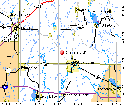
- OSM Map
- General Map
- Google Map
- MSN Map
Population change since 2000: -13.8%
 |
| Males: 286 | |
| Females: 247 |
| Median resident age: | 48.9 years |
| Wisconsin median age: | 42.6 years |
Zip codes: 53518.
| Richwood: | $62,803 |
| WI: | $70,996 |
Estimated per capita income in 2022: $33,944 (it was $17,304 in 2000)
Richwood town income, earnings, and wages data
Estimated median house or condo value in 2022: $218,610 (it was $100,300 in 2000)
| Richwood: | $218,610 |
| WI: | $252,800 |
Mean prices in 2022: all housing units: $250,850; detached houses: $261,473; townhouses or other attached units: $613,931; in 2-unit structures: $276,599; in 5-or-more-unit structures: $248,379; mobile homes: $59,249; occupied boats, rvs, vans, etc.: $29,774
Detailed information about poverty and poor residents in Richwood, WI


- 52197.7%White alone
- 50.9%Hispanic
- 40.8%Two or more races
- 10.2%Black alone
- 10.2%American Indian alone
- 10.2%Other race alone

Races in Richwood detailed stats: ancestries, foreign born residents, place of birth
 Recent articles from our blog. Our writers, many of them Ph.D. graduates or candidates, create easy-to-read articles on a wide variety of topics.

Latest news from Richwood, WI collected exclusively by city-data.com from local newspapers, TV, and radio stations
Ancestries: German (38.2%), Irish (17.0%), Norwegian (14.1%), English (13.8%), United States (8.6%), Czech (6.5%).
Current Local Time: CST time zone
Elevation: 840 feet
Land area: 41.7 square miles.
Population density: 13 people per square mile (very low).
| Richwood town: | 0.9% ($947) |
| Wisconsin: | 2.0% ($2,245) |
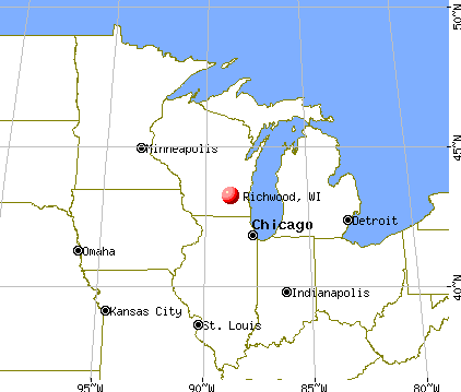
Nearest city with pop. 50,000+: La Crosse, WI  (50.0 miles , pop. 51,818).
Nearest city with pop. 200,000+: Madison, WI (62.6 miles , pop. 208,054).
Nearest city with pop. 1,000,000+: Chicago, IL (178.3 miles , pop. 2,896,016).
Nearest cities:
), ), ), ), )Latitude: 43.25 N, Longitude: 90.61 W
Area code commonly used in this area: 608


| Here: | 2.6% |
| Wisconsin: | 2.7% |

- Agriculture, forestry, fishing & hunting (16.2%)
- Construction (9.7%)
- Health care (8.4%)
- Accommodation & food services (5.0%)
- Educational services (5.0%)
- Food & beverage stores (3.8%)
- Metal & metal products (3.8%)

- Agriculture, forestry, fishing & hunting (22.6%)
- Construction (15.6%)
- Metal & metal products (4.8%)
- Accommodation & food services (4.3%)
- Wood products (4.3%)
- Nonmetallic mineral products (4.3%)
- U. S. Postal service (3.8%)

- Health care (18.7%)
- Educational services (10.4%)
- Agriculture, forestry, fishing & hunting (7.5%)
- Food & beverage stores (6.0%)
- Electronic shopping & mail-order houses (6.0%)
- Accommodation & food services (6.0%)
- Department & other general merchandise stores (5.2%)

- Farmers and farm managers (12.2%)
- Material recording, scheduling, dispatching, and distributing workers (5.6%)
- Driver/sales workers and truck drivers (5.0%)
- Other production occupations, including supervisors (5.0%)
- Other sales and related occupations, including supervisors (3.8%)
- Building and grounds cleaning and maintenance occupations (3.4%)
- Laborers and material movers, hand (3.4%)

- Farmers and farm managers (18.8%)
- Driver/sales workers and truck drivers (7.5%)
- Other sales and related occupations, including supervisors (5.4%)
- Material recording, scheduling, dispatching, and distributing workers (5.4%)
- Building and grounds cleaning and maintenance occupations (4.8%)
- Other production occupations, including supervisors (4.8%)
- Laborers and material movers, hand (4.3%)

- Information and record clerks, except customer service representatives (6.0%)
- Secretaries and administrative assistants (6.0%)
- Material recording, scheduling, dispatching, and distributing workers (6.0%)
- Other production occupations, including supervisors (5.2%)
- Preschool, kindergarten, elementary, and middle school teachers (4.5%)
- Accountants and auditors (4.5%)
- Assemblers and fabricators (4.5%)
Average climate in Richwood, Wisconsin
Based on data reported by over 4,000 weather stations


Tornado activity:
Richwood-area historical tornado activity is slightly above Wisconsin state average. It is 46% greater than the overall U.S. average.
On 4/11/1965, a category F4 (max. wind speeds 207-260 mph) tornado 9.0 miles away from the Richwood town center killed one person and injured 3 people and caused between $500,000 and $5,000,000 in damages.
On 6/7/1984, a category F5 (max. wind speeds 261-318 mph) tornado 37.3 miles away from the town center killed 9 people and injured 200 people and caused between $50,000 and $500,000 in damages.
Earthquake activity:
Richwood-area historical earthquake activity is significantly above Wisconsin state average. It is 57% greater than the overall U.S. average.On 4/18/2008 at 09:36:59, a magnitude 5.4 (5.1 MB, 4.8 MS, 5.4 MW, 5.2 MW, Class: Moderate, Intensity: VI - VII) earthquake occurred 361.0 miles away from Richwood center
On 6/28/2004 at 06:10:52, a magnitude 4.2 (4.2 MW, Depth: 6.2 mi, Class: Light, Intensity: IV - V) earthquake occurred 151.5 miles away from the city center
On 6/10/1987 at 23:48:54, a magnitude 5.1 (4.9 MB, 4.4 MS, 4.6 MS, 5.1 LG) earthquake occurred 337.6 miles away from the city center
On 4/18/2008 at 09:36:59, a magnitude 5.2 (5.2 MW, Depth: 8.9 mi) earthquake occurred 361.0 miles away from the city center
On 2/10/2010 at 09:59:35, a magnitude 3.8 (3.8 MW, Depth: 6.2 mi, Class: Light, Intensity: II - III) earthquake occurred 139.3 miles away from Richwood center
On 7/9/1975 at 14:54:15, a magnitude 4.6 (4.6 MB) earthquake occurred 315.9 miles away from Richwood center
Magnitude types: regional Lg-wave magnitude (LG), body-wave magnitude (MB), surface-wave magnitude (MS), moment magnitude (MW)
Natural disasters:
The number of natural disasters in Richland County (18) is near the US average (15).Major Disasters (Presidential) Declared: 14
Emergencies Declared: 2
Causes of natural disasters: Floods: 15, Storms: 15, Tornadoes: 8, Winds: 4, Landslides: 2, Mudslides: 2, Drought: 1, Heavy Rain: 1, Hurricane: 1, Other: 1 (Note: some incidents may be assigned to more than one category).

Hospitals and medical centers near Richwood:
- BOSCOBEL AREA HEALTH CARE Critical Access Hospitals (about 10 miles away; BOSCOBEL, WI)
- BOSCOBEL CARE AND REHAB (Nursing Home, about 10 miles away; BOSCOBEL, WI)
- GOLDEN LIVINGCENTER-RIVERDALE (Nursing Home, about 10 miles away; MUSCODA, WI)
- SCHMITT WOODLAND HILLS (Nursing Home, about 13 miles away; RICHLAND CENTER, WI)
- PINE VALLEY HLTH CARE REHAB (Nursing Home, about 14 miles away; RICHLAND CENTER, WI)
Colleges/universities with over 2000 students nearest to Richwood:
- University of Wisconsin-Platteville (about 37 miles; Platteville, WI; Full-time enrollment: 7,679)
- Viterbo University (about 50 miles; La Crosse, WI; FT enrollment: 2,848)
- University of Wisconsin-La Crosse (about 51 miles; La Crosse, WI; FT enrollment: 9,837)
- Western Technical College (about 51 miles; La Crosse, WI; FT enrollment: 3,377)
- Luther College (about 61 miles; Decorah, IA; FT enrollment: 2,700)
- Edgewood College (about 62 miles; Madison, WI; FT enrollment: 2,455)
- University of Wisconsin-Madison (about 63 miles; Madison, WI; FT enrollment: 34,621)
Points of interest:
Notable locations in Richwood: Hansons Homestead Stock and Grain Farm (A), Hill Farm (B), Larsons Homestead (C), Byrds Creek Stock Farm (D), Dawsons Empire Stock and Dairy Farm (E), Tisdale Homestead (F), Valley Farm (G), Echo Glen Stock Farm (H), Ellsworth Home Stock Farm (I), Grand Trunk Farm (J), Maple Bluff Stock Farm (K), Maple Valley Stock Farm (L), Pleasant Valley Stock Farm (M), Running Brook Stock Farm (N), Trout Brook Stock Farm (O). Display/hide their locations on the map
Church in Richwood: Richland Church (A). Display/hide its location on the map
Cemeteries: Coumbe Cemetery (1), Methodist Cemetery (2), Sand Prairie Cemetery (3), Haskins Cemetery (4), Tavera Cemetery (5), West Fork Cemetery (6), Greenwood Cemetery (7). Display/hide their locations on the map
Lakes and reservoirs: Garner Lake (A), Lower Lake (B), 1.28 Reservoir (C). Display/hide their locations on the map
Streams, rivers, and creeks: West Fork Knapp Creek (A), O'Connor Branch (B). Display/hide their locations on the map
Park in Richwood: Richwood Bottoms State Natural Area (1). Display/hide its location on the map
| This town: | 2.3 people |
| Wisconsin: | 2.4 people |
| This town: | 72.1% |
| Whole state: | 64.4% |
| This town: | 7.7% |
| Whole state: | 7.3% |
No gay or lesbian households reported
| This town: | 8.2% |
| Whole state: | 8.7% |
| This town: | 1.6% |
| Whole state: | 3.7% |
For population 15 years and over in Richwood:

- Never married: 24.9%
- Now married: 59.3%
- Separated: 1.8%
- Widowed: 5.4%
- Divorced: 8.6%
For population 25 years and over in Richwood:
- High school or higher: 82.2%
- Bachelor's degree or higher: 11.8%
- Graduate or professional degree: 2.3%
- Unemployed: 2.7%
- Mean travel time to work (commute): 30.6 minutes


| Here: | 10.1 |
| Wisconsin average: | 11.0 |
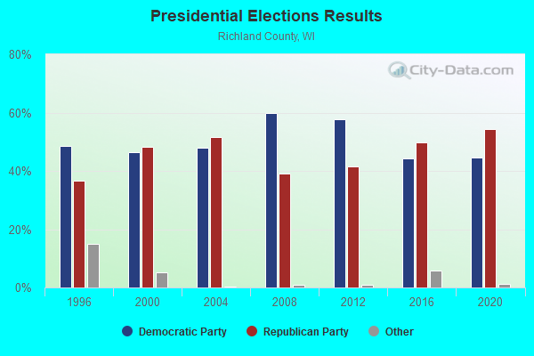
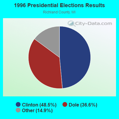
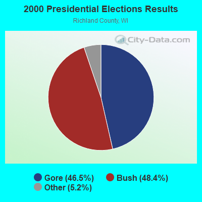
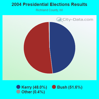

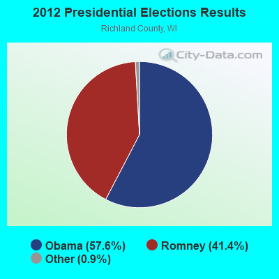
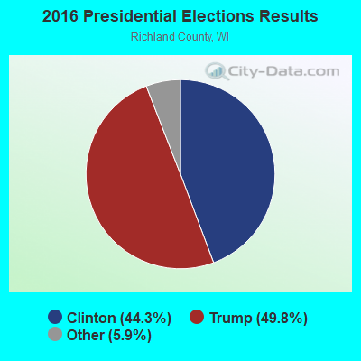
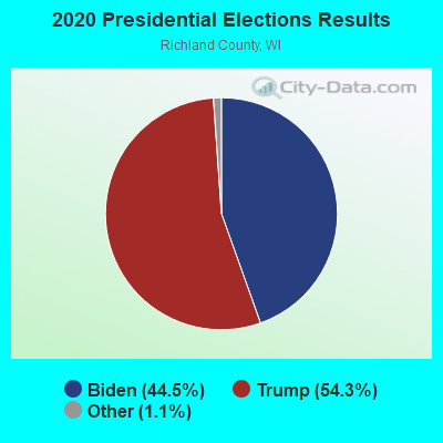
Graphs represent county-level data. Detailed 2008 Election Results
Religion statistics for Richwood, WI (based on Richland County data)
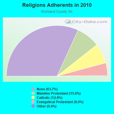
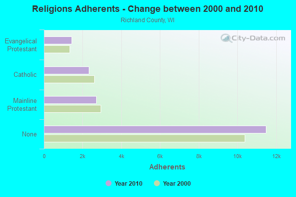
| Religion | Adherents | Congregations |
|---|---|---|
| Mainline Protestant | 2,706 | 14 |
| Catholic | 2,330 | 4 |
| Evangelical Protestant | 1,435 | 16 |
| Other | 65 | 2 |
| None | 11,485 | - |
Food Environment Statistics:
| Richland County: | 2.20 / 10,000 pop. |
| State: | 1.86 / 10,000 pop. |
| Richland County: | 0.55 / 10,000 pop. |
| Wisconsin: | 0.11 / 10,000 pop. |
| Here: | 0.55 / 10,000 pop. |
| Wisconsin: | 0.38 / 10,000 pop. |
| This county: | 5.51 / 10,000 pop. |
| Wisconsin: | 4.12 / 10,000 pop. |
| Here: | 9.36 / 10,000 pop. |
| State: | 8.64 / 10,000 pop. |
| Here: | 7.7% |
| Wisconsin: | 7.6% |
| Richland County: | 29.2% |
| State: | 27.5% |
| This county: | 17.4% |
| Wisconsin: | 13.0% |
Strongest AM radio stations in Richwood:
- WSPT (1010 AM; 50 kW; STEVENS POINT, WI)
- WRCO (1450 AM; 1 kW; RICHLAND CENTER, WI; Owner: FRUIT BROADCASTING, LLC)
- WTMJ (620 AM; 50 kW; MILWAUKEE, WI; Owner: JOURNAL BROADCAST CORPORATION)
- WKTY (580 AM; 5 kW; LA CROSSE, WI; Owner: FAMILY RADIO, INC.)
- WSCR (670 AM; 50 kW; CHICAGO, IL; Owner: INFINITY BROADCASTING OPERATIONS, INC.)
- WNAM (1280 AM; 50 kW; NEENAH-MENASHA, WI; Owner: CUMULUS LICENSING CORP.)
- WGN (720 AM; 50 kW; CHICAGO, IL; Owner: WGN CONTINENTAL BROADCASTING CO.)
- KXEL (1540 AM; 50 kW; WATERLOO, IA; Owner: KXEL BROADCASTING COMPANY, INC.)
- WISN (1130 AM; 50 kW; MILWAUKEE, WI; Owner: CAPSTAR TX LIMITED PARTNERSHIP)
- WBBM (780 AM; 50 kW; CHICAGO, IL; Owner: INFINITY BROADCASTING OPERATIONS, INC.)
- WSAU (550 AM; 20 kW; WAUSAU, WI; Owner: WRIG, INC.)
- WTSO (1070 AM; 10 kW; MADISON, WI; Owner: CAPSTAR TX LIMITED PARTNERSHIP)
- WCTS (1030 AM; 50 kW; MAPLEWOOD, MN; Owner: CNTL. BAPT. THEO/AL SEMI MINNEAPOLIS)
Strongest FM radio stations in Richwood:
- WHHI (91.3 FM; HIGHLAND, WI; Owner: STATE OF WISCONSIN - EDUCATIONAL COMMUNICATIONS BOARD)
- WRCO-FM (100.9 FM; RICHLAND CENTER, WI; Owner: FRUIT BROADCASTING, LLC)
- WJTY (88.1 FM; LANCASTER, WI; Owner: JOY PUBLIC BROADCASTING CORP.)
- WOLX-FM (94.9 FM; BARABOO, WI; Owner: ENTERCOM MADISON LICENSE, LLC.)
- WVCX (98.9 FM; TOMAH, WI; Owner: VCY AMERICA, INC.)
- WQPC (94.3 FM; PRAIRIE DU CHIEN, WI; Owner: ROBINSON CORPORATION)
- WGLR-FM (97.7 FM; LANCASTER, WI; Owner: QUEENB RADIO WISCONSIN, INC.)
- WVRQ-FM (102.3 FM; VIROQUA, WI; Owner: ROBINSON CORPORATION)
TV broadcast stations around Richwood:
- WDLS-LP (Channel 35; TOMAH, WI; Owner: MAGNUM RADIO, INC.)
- W22CI (Channel 22; BLOOMINGTON, WI; Owner: STATE OF WISCONSIN - EDUCATIONAL COMMUNICATIONS BOARD)
- National Bridge Inventory (NBI) Statistics
- 26Number of bridges
- 187ft / 57.5mTotal length
- $2,750,000Total costs
- 10,326Total average daily traffic
- 599Total average daily truck traffic
- 11,577Total future (year 2037) average daily traffic

- New bridges - historical statistics
- 81950-1959
- 41960-1969
- 31970-1979
- 41980-1989
- 51990-1999
- 22000-2009
FCC Registered Antenna Towers:
3- MARK HEINZE, .3 M South Of Cth Q On Welsh Rd. (Lat: 43.237222 Lon: -88.759722), Type: 97.5, Structure height: 55027 m, Overall height: 97.5 m, Registrant: Wisconsin Electric Power Company, Chris.Buckmaster@we-Energires.Com, A026, 2046 Milwa-ukee, Phone: (414) 221-2081
- Mark Heinze, .3 M South Of Cth Q On Welsh Rd. (Lat: 43.237222 Lon: -88.759722), Type: 97.5, Structure height: 55027 m, Overall height: 97.5 m, Registrant: Wisconsin Electric Power Company, Christopher.Buckmaster@wecenergygroup.Com, , 2046 Milwa-ukee, Phone: (414) 221-2081
- .3 M South Of Cth Q On Welsh Rd. (Lat: 43.237222 Lon: -88.759722), Type: 97.5, Overall height: 97.5 m, Registrant: Wisconsin Electric Power Company, Mike.Kelley@wemail.Wisenergy.Com, , P.O. BOX 2046 Milwa-ukee, Phone: (414) 221-2226
FCC Registered Private Land Mobile Towers:
1- .3 M South Of Cth Q On Welsh Rd. (Lat: 43.237222 Lon: -88.759722), Type: Tower, Structure height: 97.5 m, Call Sign: WNUM413,
Assigned Frequencies: 462.825 MHz, Grant Date: 11/03/2020, Expiration Date: 10/05/2030, Registrant: 333 W. Everett St, Milwaukee, WI 53203, Phone: (414) 221-2081, Fax: (414) 221-3198, Email:
FCC Registered Microwave Towers:
6- STATION, W Side Of Welsh Rd .3 Mi S Of Q (Lat: 43.262472 Lon: -88.759806), Overall height: 84.4 m, Call Sign: WNTC486,
Assigned Frequencies: 952.706 MHz, 928.706 MHz, Grant Date: 03/07/2020, Expiration Date: 04/18/2030, Certifier: Signature On File, Registrant: Mc Dermott Will & Emery, 333 W. Everett St, Milwaukee, WI 53203, Phone: (414) 221-2081, Fax: (414) 221-3198, Email:
- STATION, .3 Mi S Of Q On W Side Of Welsh Rd (Lat: 43.237194 Lon: -88.759806), Overall height: 97.5 m, Call Sign: WNTH914,
Assigned Frequencies: 952.418 MHz, 928.418 MHz, 952.506 MHz, 928.506 MHz, Grant Date: 12/02/2020, Expiration Date: 01/29/2031, Registrant: 333 W. Everett St, Milwaukee, WI 53203, Phone: (414) 221-2081, Fax: (414) 221-3198, Email:
- WATERTOWN, .3 M South Of Cth Q On Welsh Rd. (Lat: 43.237222 Lon: -88.759722), Type: Gtower, Structure height: 97.5 m, Call Sign: WNTP234,
Assigned Frequencies: 6645.00 MHz, 6315.84 MHz, 6226.89 MHz, 6315.84 MHz, 6226.89 MHz, 6315.84 MHz, 6226.89 MHz, 6315.84 MHz, 6226.89 MHz, 6315.84 MHz... (+18 more), Grant Date: 01/03/2019, Expiration Date: 02/28/2029, Registrant: Wisconsin Electric Power Company, 333 W. Everett St, Milwaukee, WI 53203, Phone: (414) 221-2081, Fax: (414) 221-3198, Email:
- STATION, .3 Mi S Of Q On W Side Of Welsh Rd (Lat: 43.237194 Lon: -88.759806), Overall height: 97.5 m, Call Sign: WNTQ975,
Assigned Frequencies: 2196.80 MHz, Grant Date: 03/29/1993, Expiration Date: 03/29/1998, Cancellation Date: 12/14/1995, Phone: (414) 221-2226
- Watertown RT, Lat: 43.237222 Lon: -88.759722, Type: Ltower, Structure height: 97.5 m, Call Sign: WQNN671,
Assigned Frequencies: 3650.00 MHz, Grant Date: 04/01/2011, Expiration Date: 04/01/2021, Cancellation Date: 04/12/2021, Certifier: Michael J Kelley, Registrant: Wisconsin Electric Power Company, 333 W. Everett St, Milwaukee, WI 53203, Phone: (414) 221-2081, Fax: (414) 221-3198, Email:
- WE Energies Twr, .3 M South Of Cth Q On Welsh Rd. (Lat: 43.237222 Lon: -88.759722), Type: Gtower, Structure height: 97.5 m, Call Sign: WRVN682,
Assigned Frequencies: 11055.0 MHz, 11175.0 MHz, 11055.0 MHz, 11175.0 MHz, 11055.0 MHz, 11175.0 MHz, 11055.0 MHz, 11175.0 MHz, Grant Date: 12/14/2022, Expiration Date: 12/14/2032, Certifier: Todd Lindert, Registrant: Micronet Communications, Inc., 812 Lexington Dr, Plano, TX 75075, Phone: (972) 422-7200, Email:

- 74.9%Bottled, tank, or LP gas
- 15.5%Wood
- 4.3%Electricity
- 3.9%Fuel oil, kerosene, etc.
- 1.4%Utility gas

- 57.1%Bottled, tank, or LP gas
- 21.4%Fuel oil, kerosene, etc.
- 14.3%Wood
- 7.1%Utility gas
Richwood compared to Wisconsin state average:
- Unemployed percentage significantly below state average.
- Black race population percentage significantly below state average.
- Hispanic race population percentage significantly below state average.
- Median age above state average.
- Foreign-born population percentage significantly below state average.
- Renting percentage significantly below state average.
- Length of stay since moving in significantly above state average.
- Number of rooms per house significantly below state average.
- House age significantly below state average.
- Percentage of population with a bachelor's degree or higher below state average.