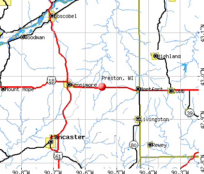
Preston, Wisconsin
Submit your own pictures of this town and show them to the world
- OSM Map
- General Map
- Google Map
- MSN Map
Population change since 2000: +2.4%
 |
| Males: 699 | |
| Females: 694 |
| Median resident age: | 52.2 years |
| Wisconsin median age: | 42.6 years |
Zip codes: 53934.
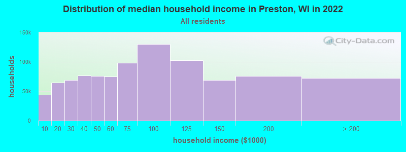
| Preston: | $54,243 |
| WI: | $70,996 |
Estimated per capita income in 2022: $34,702 (it was $19,117 in 2000)
Preston town income, earnings, and wages data
Estimated median house or condo value in 2022: $194,851 (it was $82,400 in 2000)
| Preston: | $194,851 |
| WI: | $252,800 |
Mean prices in 2022: all housing units: $226,508; detached houses: $254,100; townhouses or other attached units: $301,444; in 2-unit structures: $162,432; in 3-to-4-unit structures: $303,631; in 5-or-more-unit structures: $204,663; mobile homes: $107,260; occupied boats, rvs, vans, etc.: $47,510
Detailed information about poverty and poor residents in Preston, WI


- 1,30994.0%White alone
- 392.8%Hispanic
- 171.2%Two or more races
- 130.9%American Indian alone
- 90.6%Black alone
- 60.4%Asian alone
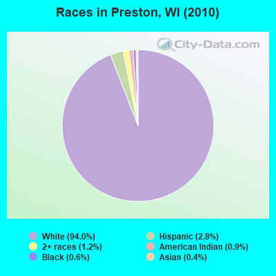
Races in Preston detailed stats: ancestries, foreign born residents, place of birth
 Recent articles from our blog. Our writers, many of them Ph.D. graduates or candidates, create easy-to-read articles on a wide variety of topics.

 | Billings MT or Onalaska WI???? (22 replies) |
Latest news from Preston, WI collected exclusively by city-data.com from local newspapers, TV, and radio stations
Ancestries: German (44.7%), Irish (14.0%), Polish (10.7%), English (9.4%), Norwegian (9.4%), United States (4.7%).
Current Local Time: CST time zone
Elevation: 1160 feet
Land area: 35.4 square miles.
Population density: 39 people per square mile (very low).
33 residents are foreign born (2.1% Europe, 0.4% Asia).
| This town: | 2.4% |
| Wisconsin: | 3.6% |
| Preston town: | 1.7% ($1,410) |
| Wisconsin: | 2.0% ($2,245) |
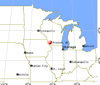
Nearest city with pop. 50,000+: Oshkosh, WI  (61.5 miles , pop. 62,916).
Nearest city with pop. 200,000+: Madison, WI (68.3 miles , pop. 208,054).
Nearest city with pop. 1,000,000+: Chicago, IL (184.7 miles , pop. 2,896,016).
Nearest cities:
), ), ), ), ), ), Latitude: 44.02 N, Longitude: 89.79 W
Area code commonly used in this area: 608

| Here: | 5.3% |
| Wisconsin: | 2.7% |
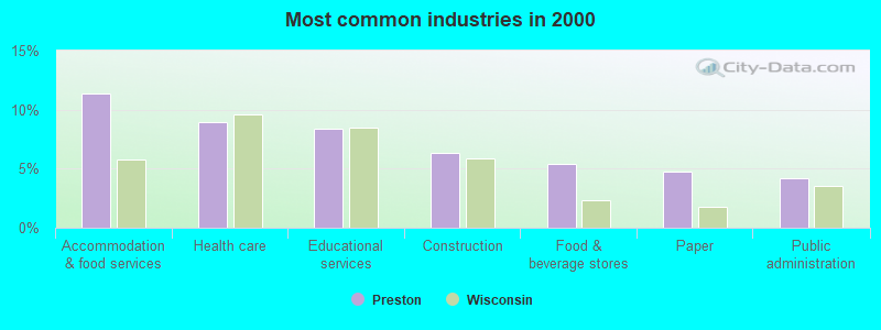
- Accommodation & food services (11.4%)
- Health care (8.9%)
- Educational services (8.4%)
- Construction (6.3%)
- Food & beverage stores (5.4%)
- Paper (4.7%)
- Public administration (4.2%)
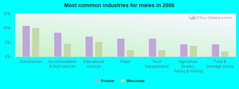
- Construction (10.9%)
- Accommodation & food services (8.5%)
- Educational services (7.1%)
- Paper (6.5%)
- Truck transportation (6.5%)
- Agriculture, forestry, fishing & hunting (4.4%)
- Food & beverage stores (4.4%)
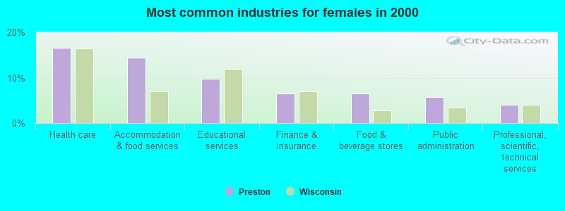
- Health care (16.5%)
- Accommodation & food services (14.4%)
- Educational services (9.7%)
- Finance & insurance (6.5%)
- Food & beverage stores (6.5%)
- Public administration (5.8%)
- Professional, scientific, technical services (4.0%)
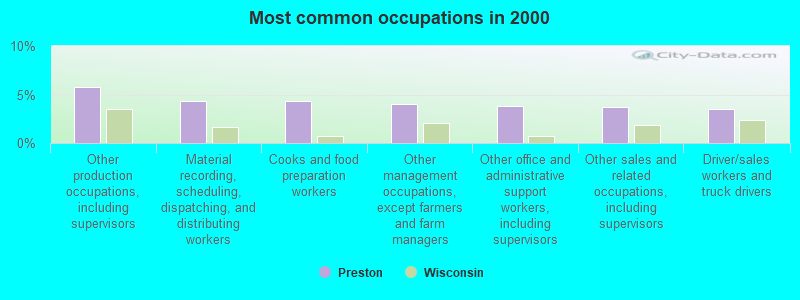
- Other production occupations, including supervisors (5.8%)
- Material recording, scheduling, dispatching, and distributing workers (4.4%)
- Cooks and food preparation workers (4.4%)
- Other management occupations, except farmers and farm managers (4.0%)
- Other office and administrative support workers, including supervisors (3.8%)
- Other sales and related occupations, including supervisors (3.7%)
- Driver/sales workers and truck drivers (3.5%)
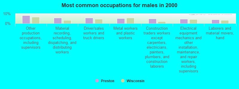
- Other production occupations, including supervisors (8.2%)
- Material recording, scheduling, dispatching, and distributing workers (5.8%)
- Driver/sales workers and truck drivers (5.8%)
- Metal workers and plastic workers (5.1%)
- Construction traders workers except carpenters, electricians, painters, plumbers, and construction laborers (4.8%)
- Electrical equipment mechanics and other installation, maintenance, and repair workers, including supervisors (4.4%)
- Laborers and material movers, hand (4.1%)
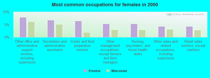
- Other office and administrative support workers, including supervisors (7.9%)
- Secretaries and administrative assistants (6.8%)
- Cooks and food preparation workers (6.5%)
- Other management occupations, except farmers and farm managers (5.4%)
- Nursing, psychiatric, and home health aides (5.4%)
- Other sales and related occupations, including supervisors (4.3%)
- Retail sales workers, except cashiers (4.3%)
Average climate in Preston, Wisconsin
Based on data reported by over 4,000 weather stations


(lower is better)
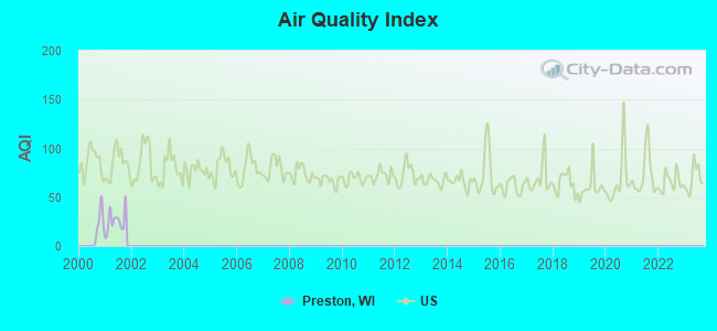
Air Quality Index (AQI) level in 2001 was 25.9. This is significantly better than average.
| City: | 25.9 |
| U.S.: | 72.6 |
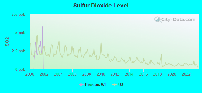
Sulfur Dioxide (SO2) [ppb] level in 2001 was 3.05. This is significantly worse than average. Closest monitor was 13.6 miles away from the city center.
| City: | 3.05 |
| U.S.: | 1.51 |
Tornado activity:
Preston-area historical tornado activity is slightly above Wisconsin state average. It is 46% greater than the overall U.S. average.
On 4/19/1957, a category F4 (max. wind speeds 207-260 mph) tornado 17.8 miles away from the Preston town center killed one person and caused between $5000 and $50,000 in damages.
On 8/27/1994, a category F3 (max. wind speeds 158-206 mph) tornado 8.6 miles away from the town center killed 2 people and injured 22 people and caused between $500,000 and $5,000,000 in damages.
Earthquake activity:
Preston-area historical earthquake activity is significantly above Wisconsin state average. It is 16% greater than the overall U.S. average.On 6/28/2004 at 06:10:52, a magnitude 4.2 (4.2 MW, Depth: 6.2 mi, Class: Light, Intensity: IV - V) earthquake occurred 182.7 miles away from Preston center
On 4/18/2008 at 09:36:59, a magnitude 5.4 (5.1 MB, 4.8 MS, 5.4 MW, 5.2 MW, Class: Moderate, Intensity: VI - VII) earthquake occurred 397.6 miles away from the city center
On 6/10/1987 at 23:48:54, a magnitude 5.1 (4.9 MB, 4.4 MS, 4.6 MS, 5.1 LG) earthquake occurred 372.9 miles away from Preston center
On 4/18/2008 at 09:36:59, a magnitude 5.2 (5.2 MW, Depth: 8.9 mi) earthquake occurred 397.6 miles away from Preston center
On 2/10/2010 at 09:59:35, a magnitude 3.8 (3.8 MW, Depth: 6.2 mi, Class: Light, Intensity: II - III) earthquake occurred 156.2 miles away from the city center
On 5/2/2015 at 16:23:07, a magnitude 4.2 (4.2 MW, Depth: 2.8 mi) earthquake occurred 252.3 miles away from Preston center
Magnitude types: regional Lg-wave magnitude (LG), body-wave magnitude (MB), surface-wave magnitude (MS), moment magnitude (MW)
Natural disasters:
The number of natural disasters in Adams County (11) is smaller than the US average (15).Major Disasters (Presidential) Declared: 8
Emergencies Declared: 2
Causes of natural disasters: Floods: 8, Storms: 7, Tornadoes: 4, Drought: 1, Hurricane: 1, Landslide: 1, Mudslide: 1, Wind: 1, Other: 1 (Note: some incidents may be assigned to more than one category).

Colleges/universities with over 2000 students nearest to Preston:
- Mid-State Technical College (about 26 miles; Wisconsin Rapids, WI; Full-time enrollment: 2,128)
- University of Wisconsin-Stevens Point (about 37 miles; Stevens Point, WI; FT enrollment: 9,089)
- University of Wisconsin-Oshkosh (about 62 miles; Oshkosh, WI; FT enrollment: 10,637)
- Herzing University-Madison (about 66 miles; Madison, WI; FT enrollment: 3,160)
- Madison Area Technical College (about 67 miles; Madison, WI; FT enrollment: 9,603)
- Northcentral Technical College (about 68 miles; Wausau, WI; FT enrollment: 3,356)
- University of Wisconsin-Madison (about 69 miles; Madison, WI; FT enrollment: 34,621)
Points of interest:
Cemeteries: Cottonville Cemetery (1), Indian Cemetery (2). Display/hide their locations on the map
Reservoirs: Big Roche a Cri Lake (A), 50 Reservoir (B), Big Roche Lake 71 (C), Friendship Lake (D). Display/hide their locations on the map
Creeks: Bingham Creek (A), Fordham Creek (B). Display/hide their locations on the map
Parks in Preston include: Roche-A-Cri Mound State Natural Area (1), Roche-A-Cri Woods State Natural Area (2), Roche a Cri State Park (3). Display/hide their locations on the map
| This town: | 2.2 people |
| Wisconsin: | 2.4 people |
| This town: | 68.2% |
| Whole state: | 64.4% |
| This town: | 6.8% |
| Whole state: | 7.3% |
Likely homosexual households (counted as self-reported same-sex unmarried-partner households)
- Lesbian couples: 0.3% of all households
- Gay men: 0.2% of all households
| This town: | 9.6% |
| Whole state: | 8.7% |
| This town: | 3.7% |
| Whole state: | 3.7% |
For population 15 years and over in Preston:
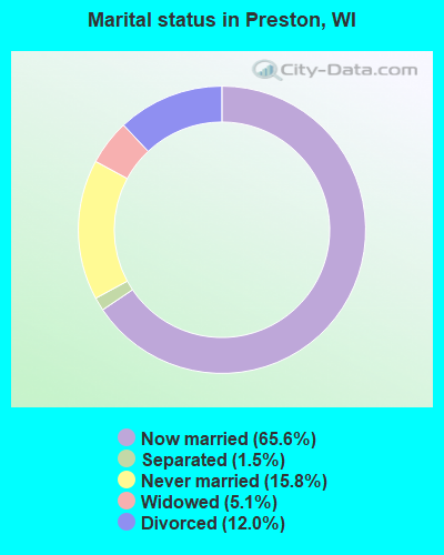
- Never married: 15.8%
- Now married: 65.6%
- Separated: 1.5%
- Widowed: 5.1%
- Divorced: 12.0%
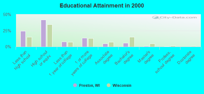
For population 25 years and over in Preston:
- High school or higher: 76.0%
- Bachelor's degree or higher: 8.0%
- Graduate or professional degree: 2.0%
- Unemployed: 9.4%
- Mean travel time to work (commute): 20.0 minutes
| Here: | 9.4 |
| Wisconsin average: | 11.0 |
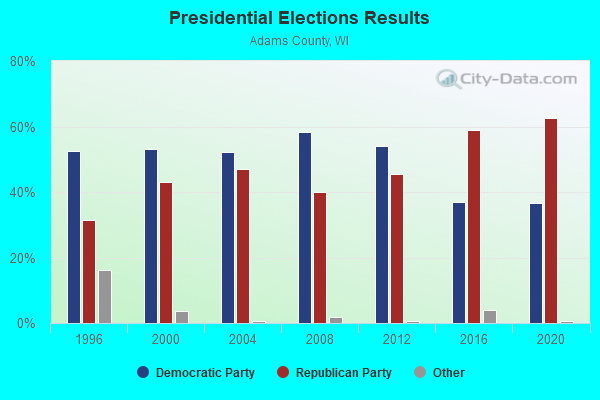
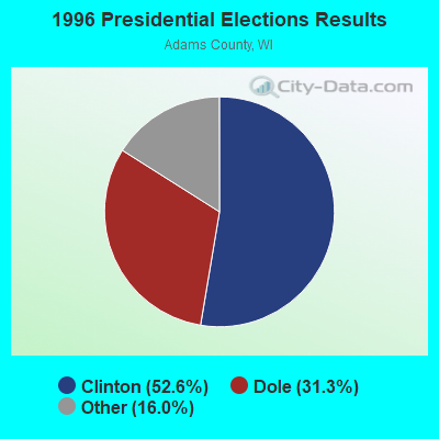
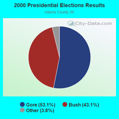
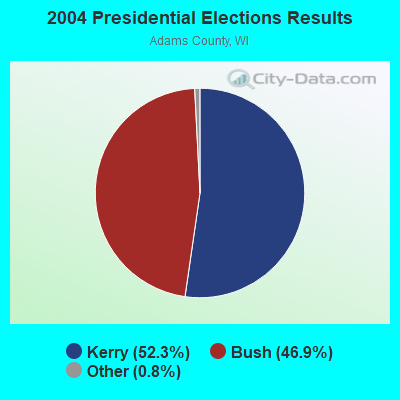
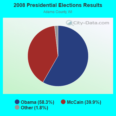
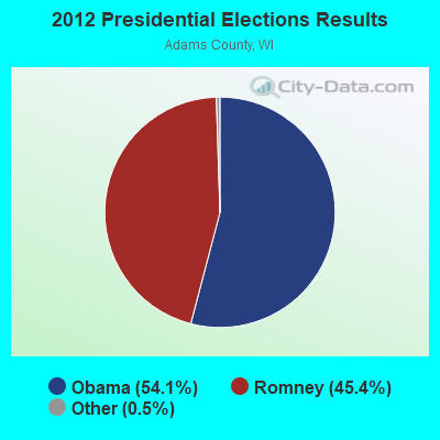
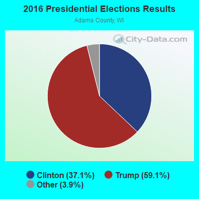
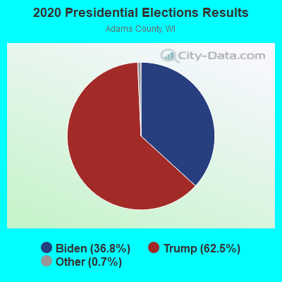
Graphs represent county-level data. Detailed 2008 Election Results
Religion statistics for Preston, WI (based on Adams County data)
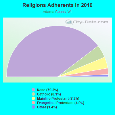
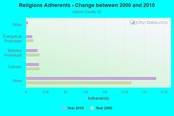
| Religion | Adherents | Congregations |
|---|---|---|
| Catholic | 1,700 | 2 |
| Mainline Protestant | 1,511 | 9 |
| Evangelical Protestant | 839 | 8 |
| Other | 289 | 2 |
| None | 16,536 | - |
Food Environment Statistics:
| Adams County: | 0.49 / 10,000 pop. |
| Wisconsin: | 1.86 / 10,000 pop. |
| Adams County: | 0.49 / 10,000 pop. |
| Wisconsin: | 0.38 / 10,000 pop. |
| Here: | 3.41 / 10,000 pop. |
| Wisconsin: | 4.12 / 10,000 pop. |
| Adams County: | 7.80 / 10,000 pop. |
| Wisconsin: | 8.64 / 10,000 pop. |
| Adams County: | 9.2% |
| Wisconsin: | 7.6% |
| Adams County: | 28.7% |
| Wisconsin: | 27.5% |
| Here: | 13.8% |
| State: | 13.0% |
Strongest AM radio stations in Preston:
- WSPT (1010 AM; 50 kW; STEVENS POINT, WI)
- WNAM (1280 AM; 50 kW; NEENAH-MENASHA, WI; Owner: CUMULUS LICENSING CORP.)
- WSAU (550 AM; 20 kW; WAUSAU, WI; Owner: WRIG, INC.)
- WHBY (1150 AM; 25 kW; KIMBERLY, WI; Owner: WOODWARD COMMUNICATIONS, INC.)
- WFHR (1320 AM; 5 kW; WISCONSIN RAPIDS, WI; Owner: WISCONSIN RAPIDS BROADCASTING, LLC)
- WTMJ (620 AM; 50 kW; MILWAUKEE, WI; Owner: JOURNAL BROADCAST CORPORATION)
- WDUX (800 AM; 5 kW; WAUPACA, WI; Owner: LAIRD BROADCASTING COMPANY, INC.)
- WISN (1130 AM; 50 kW; MILWAUKEE, WI; Owner: CAPSTAR TX LIMITED PARTNERSHIP)
- WLBL (930 AM; 5 kW; AUBURNDALE, WI; Owner: STATE OF WISCONSIN - EDUCATIONAL COMMUNICATIONS BOARD)
- WSCR (670 AM; 50 kW; CHICAGO, IL; Owner: INFINITY BROADCASTING OPERATIONS, INC.)
- WGN (720 AM; 50 kW; CHICAGO, IL; Owner: WGN CONTINENTAL BROADCASTING CO.)
- WBBM (780 AM; 50 kW; CHICAGO, IL; Owner: INFINITY BROADCASTING OPERATIONS, INC.)
- WRIG (1390 AM; 10 kW; SCHOFIELD, WI; Owner: WRIG, INC.)
Strongest FM radio stations in Preston:
- WDKM (106.1 FM; ADAMS, WI; Owner: ROCHE-A-CRI BROADCASTING)
- WGLX-FM (103.3 FM; WISCONSIN RAPIDS, WI; Owner: WISCONSIN RAPIDS BROADCASTING, LLC)
- WMMA (93.9 FM; NEKOOSA, WI; Owner: STARBOARD BROADCASTING, INC.)
- WOLX-FM (94.9 FM; BARABOO, WI; Owner: ENTERCOM MADISON LICENSE, LLC.)
- WVCX (98.9 FM; TOMAH, WI; Owner: VCY AMERICA, INC.)
- WRJC-FM (92.1 FM; MAUSTON, WI; Owner: WRJC, INCORPORATED)
- WIZD (99.9 FM; RUDOLPH, WI; Owner: WRIG, INC)
TV broadcast stations around Preston:
- W64AU (Channel 64; ADAMS, WI; Owner: STATE OF WISCONSIN - EDUCATIONAL COMMUNICATIONS BOARD)
- WDLS-LP (Channel 35; TOMAH, WI; Owner: MAGNUM RADIO, INC.)
- W24BV (Channel 24; WHITING, WI; Owner: MS COMMUNICATIONS, LLC)
- W60CI (Channel 60; WHITING, WI; Owner: MS COMMUNICATIONS, LLC)
- National Bridge Inventory (NBI) Statistics
- 12Number of bridges
- 66ft / 20.3mTotal length
- 17,428Total average daily traffic
- 436Total average daily truck traffic
- 20,878Total future (year 2037) average daily traffic
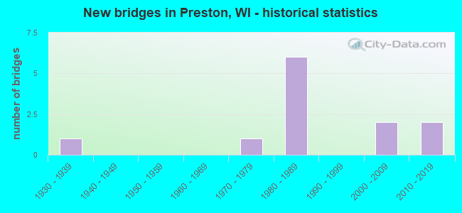
- New bridges - historical statistics
- 11930-1939
- 11970-1979
- 61980-1989
- 22000-2009
- 22010-2019
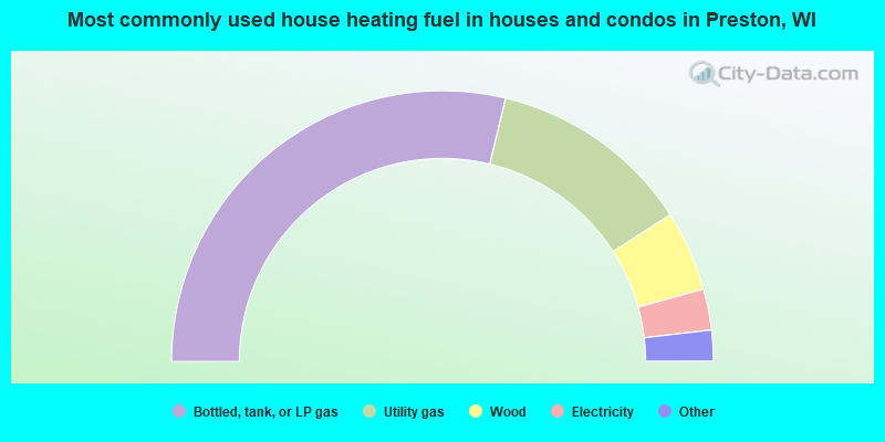
- 57.5%Bottled, tank, or LP gas
- 24.3%Utility gas
- 9.6%Wood
- 4.9%Electricity
- 3.3%Fuel oil, kerosene, etc.
- 0.4%No fuel used
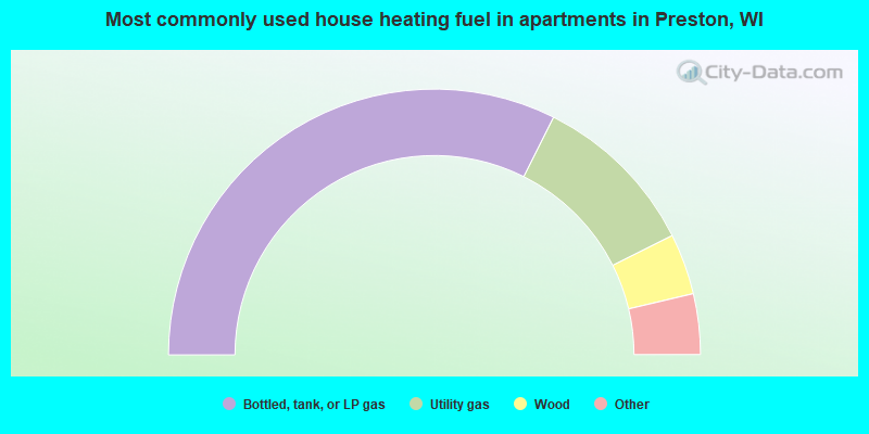
- 64.8%Bottled, tank, or LP gas
- 20.4%Utility gas
- 7.4%Wood
- 3.7%Electricity
- 3.7%Fuel oil, kerosene, etc.
Preston compared to Wisconsin state average:
- Black race population percentage significantly below state average.
- Hispanic race population percentage below state average.
- Median age significantly above state average.
- Foreign-born population percentage below state average.
- Renting percentage significantly below state average.
- Length of stay since moving in significantly above state average.
- Number of rooms per house significantly below state average.
- House age significantly below state average.
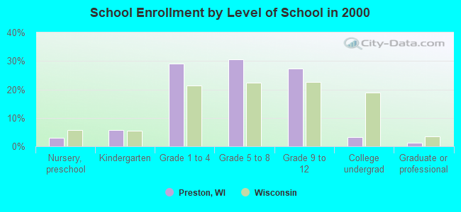
- Number of college students significantly below state average.
- Percentage of population with a bachelor's degree or higher significantly below state average.