Powell Butte, Oregon
Submit your own pictures of this place and show them to the world
- OSM Map
- General Map
- Google Map
- MSN Map
| Males: 1,208 | |
| Females: 1,195 |
| Median resident age: | 43.6 years |
| Oregon median age: | 36.3 years |
Zip code: 97753
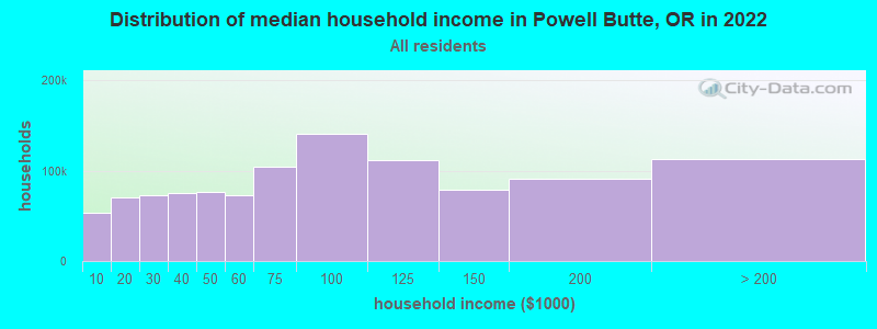
| Powell Butte: | $105,865 |
| OR: | $75,657 |
Estimated per capita income in 2022: $51,807 (it was $22,391 in 2000)
Powell Butte CCD income, earnings, and wages data
Estimated median house or condo value in 2022: $841,073 (it was $202,400 in 2000)
| Powell Butte: | $841,073 |
| OR: | $475,600 |
Detailed information about poverty and poor residents in Powell Butte, OR
Compare current foreclosures near Powell Butte, OR:
| Photo | Address | Area | Beds / Baths | Price | Details |
|---|---|---|---|---|---|

|
#1
SW Powell Butte Hwy
Powell Butte, OR 97753
|
4,475 sq. feet
|
4 baths 5 beds |
show details | |

|
#2
SW Highway 126
Powell Butte, OR 97753
|
997 sq. feet
|
1 baths 2 beds |
show details | |

|
#3
SW Powell Butte Hwy
Powell Butte, OR 97753
|
- sq. feet
|
- baths - beds |
show details | |

|
#4
SW Raven Ln
Powell Butte, OR 97753
|
- sq. feet
|
- baths - beds |
show details | |

|
#5
SW Ranchview Rd
Powell Butte, OR 97753
|
- sq. feet
|
- baths - beds |
show details | |

|
#6
Stonewood Dr
Bend, OR 97701
|
2,052 sq. feet
|
2 baths 3 beds |
show details | |

|
#7
SE 4th St
Prineville, OR 97754
|
960 sq. feet
|
1 baths 2 beds |
show details | |

|
#8
SE Antler Ln
Prineville, OR 97754
|
187 sq. feet
|
2 baths 3 beds |
show details | |

|
#9
NE Upas Ave
Redmond, OR 97756
|
950 sq. feet
|
2 baths 3 beds |
show details | |

|
#10
Oakview Dr
Bend, OR 97701
|
2,040 sq. feet
|
2 baths 3 beds |
show details |
| Photo | Address | Area | Beds / Baths | Price | Details |
|---|---|---|---|---|---|

|
#11
NE 45th St
Redmond, OR 97756
|
1,506 sq. feet
|
2 baths 3 beds |
show details | |

|
#12
NE Shoshone Ct
Redmond, OR 97756
|
1,188 sq. feet
|
2 baths 3 beds |
show details | |

|
#13
SW 4th St
Prineville, OR 97754
|
1,848 sq. feet
|
1 baths 3 beds |
show details | |

|
#14
SW Quartz Ave
Redmond, OR 97756
|
1,008 sq. feet
|
2 baths 3 beds |
show details | |

|
#15
NW Jordan Ave
Prineville, OR 97754
|
1,839 sq. feet
|
2 baths 3 beds |
show details | |

|
#16
NW Larch Dr
Redmond, OR 97756
|
2,890 sq. feet
|
3 baths 4 beds |
show details | |

|
#17
SW 33rd St
Redmond, OR 97756
|
1,409 sq. feet
|
2 baths 3 beds |
show details | |

|
#18
SW Pumice Ave
Redmond, OR 97756
|
1,008 sq. feet
|
2 baths 3 beds |
show details | |

|
#19
SW Newberry Ave
Redmond, OR 97756
|
1,235 sq. feet
|
2 baths 3 beds |
show details | |

|
#20
SW 31st St
Redmond, OR 97756
|
2,628 sq. feet
|
4 baths 4 beds |
show details |
| Photo | Address | Area | Beds / Baths | Price | Details |
|---|---|---|---|---|---|

|
#21
SW Volcano Cir
Redmond, OR 97756
|
1,384 sq. feet
|
2 baths 3 beds |
show details | |

|
#22
SW 30th St
Redmond, OR 97756
|
1,088 sq. feet
|
1 baths 3 beds |
show details | |

|
#23
Snowcap Ct
Bend, OR 97701
|
1,060 sq. feet
|
2 baths 3 beds |
show details | |

|
#24
SW 29th St
Redmond, OR 97756
|
1,279 sq. feet
|
2 baths 3 beds |
show details | |

|
#25
NW Grizzly Mt Rd
Prineville, OR 97754
|
2,384 sq. feet
|
3 baths 5 beds |
show details | |

|
#26
SW 35th St
Redmond, OR 97756
|
1,525 sq. feet
|
2 baths 3 beds |
show details | |

|
#27
SW Indian Pl
Redmond, OR 97756
|
1,608 sq. feet
|
2 baths 4 beds |
show details | |

|
#28
NE Cobblestone Ct
Prineville, OR 97754
|
1,924 sq. feet
|
2 baths 3 beds |
show details | |

|
#29
NW Country Loop
Prineville, OR 97754
|
2,024 sq. feet
|
2 baths 3 beds |
show details | |

|
#30
SE 6th St
Prineville, OR 97754
|
1,008 sq. feet
|
1 baths 2 beds |
show details |
| Photo | Address | Area | Beds / Baths | Price | Details |
|---|---|---|---|---|---|

|
#31
SE Elm St
Prineville, OR 97754
|
1,492 sq. feet
|
1 baths 3 beds |
show details | |

|
#32
NW Overlook Ln
Prineville, OR 97754
|
1,320 sq. feet
|
1 baths 2 beds |
show details | |

|
#33
SE Fairview St
Prineville, OR 97754
|
1,437 sq. feet
|
1 baths 2 beds |
show details | |

|
#34
SW Wickiup Ave
Redmond, OR 97756
|
2,112 sq. feet
|
4 baths 7 beds |
show details | |

|
#35
13th St
Terrebonne, OR 97760
|
2,368 sq. feet
|
2 baths 3 beds |
show details | |

|
#36
NE Laughlin Rd
Prineville, OR 97754
|
746 sq. feet
|
1 baths 2 beds |
show details | |

|
#37
NE Tennessee Ln
Prineville, OR 97754
|
1,284 sq. feet
|
2 baths 3 beds |
show details | |

|
#38
SE 2nd St
Prineville, OR 97754
|
2,264 sq. feet
|
2 baths 5 beds |
show details | |

|
#39
NE Clifton Ave
Prineville, OR 97754
|
1,766 sq. feet
|
2 baths 3 beds |
show details | |

|
#40
SW Lava Ave
Redmond, OR 97756
|
1,008 sq. feet
|
2 baths 3 beds |
show details |
| Photo | Address | Area | Beds / Baths | Price | Details |
|---|---|---|---|---|---|

|
#41
SW Meadowlakes Dr
Prineville, OR 97754
|
1,780 sq. feet
|
2 baths 3 beds |
show details | |

|
#42
NW Kingwood Ave
Redmond, OR 97756
|
1,710 sq. feet
|
2 baths 3 beds |
show details | |

|
#43
NE Wyoming Dr
Prineville, OR 97754
|
2,453 sq. feet
|
2 baths 3 beds |
show details | |

|
#44
NW Elm Ave
Redmond, OR 97756
|
819 sq. feet
|
1 baths 2 beds |
show details | |

|
#45
NW 9th Ln
Redmond, OR 97756
|
1,428 sq. feet
|
2 baths 3 beds |
show details | |

|
#46
SW Rimrock Way
Redmond, OR 97756
|
2,464 sq. feet
|
4 baths 6 beds |
show details | |

|
#47
NW 19th St Unit 16
Redmond, OR 97756
|
1,476 sq. feet
|
2 baths 3 beds |
show details | |

|
#48
NW Dove Rd
Terrebonne, OR 97760
|
2,585 sq. feet
|
2 baths 4 beds |
show details | |

|
#49
NW Ivy Ave
Redmond, OR 97756
|
1,872 sq. feet
|
2 baths 4 beds |
show details | |

|
Check over 1 million property listings on Foreclosure.com!
|
browse all offers | |||

- 1,90693.4%White alone
- 793.9%Hispanic
- 201.0%American Indian alone
- 170.8%Two or more races
- 150.7%Asian alone
- 30.1%Other race alone
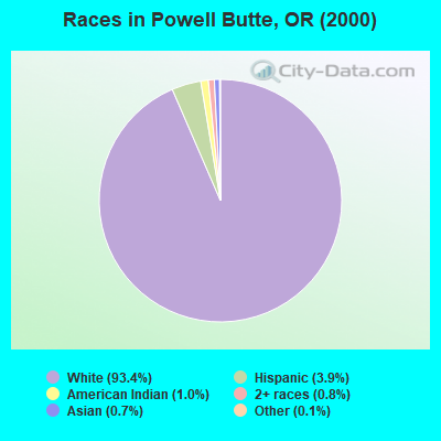
Races in Powell Butte detailed stats: ancestries, foreign born residents, place of birth
 Recent articles from our blog. Our writers, many of them Ph.D. graduates or candidates, create easy-to-read articles on a wide variety of topics.

Current Local Time: PST time zone
Elevation: 3120 feet
Land area: 144.6 square miles.
Population density: 17 people per square mile (very low).
| Powell Butte CCD: | 0.8% ($1,598) |
| Oregon: | 1.2% ($1,687) |
Nearest city with pop. 50,000+: Bend, OR  (19.7 miles , pop. 52,029).
Nearest city with pop. 200,000+: Northwest Clackamas, OR (111.2 miles , pop. 224,220).
Nearest city with pop. 1,000,000+: Los Angeles, CA (717.4 miles , pop. 3,694,820).
Nearest cities:
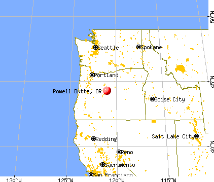
), Latitude: 44.25 N, Longitude: 121.02 W
Area code commonly used in this area: 541

| Here: | 6.2% |
| Oregon: | 3.9% |
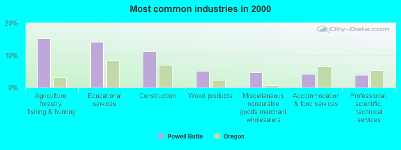
- Agriculture, forestry, fishing & hunting (15.2%)
- Educational services (14.0%)
- Construction (11.1%)
- Wood products (5.1%)
- Miscellaneous nondurable goods merchant wholesalers (4.7%)
- Accommodation & food services (4.2%)
- Professional, scientific, technical services (3.9%)
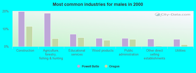
- Construction (19.8%)
- Agriculture, forestry, fishing & hunting (18.8%)
- Educational services (7.0%)
- Wood products (4.7%)
- Public administration (4.7%)
- Other direct selling establishments (4.3%)
- Utilities (4.1%)
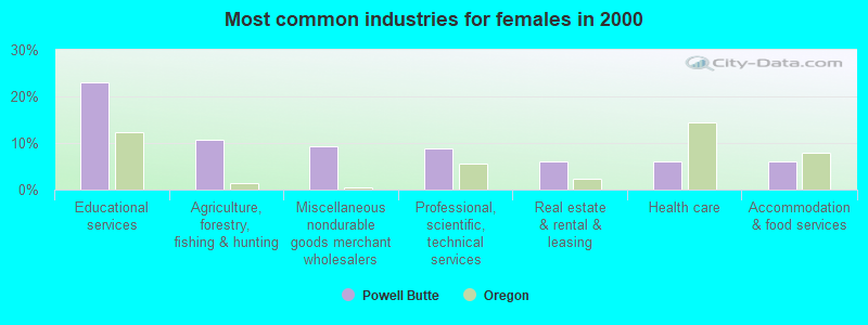
- Educational services (23.0%)
- Agriculture, forestry, fishing & hunting (10.6%)
- Miscellaneous nondurable goods merchant wholesalers (9.4%)
- Professional, scientific, technical services (8.9%)
- Real estate & rental & leasing (5.9%)
- Health care (5.9%)
- Accommodation & food services (5.9%)

- Driver/sales workers and truck drivers (6.4%)
- Secretaries and administrative assistants (5.5%)
- Preschool, kindergarten, elementary, and middle school teachers (5.2%)
- Other management occupations, except farmers and farm managers (5.2%)
- Other sales and related occupations, including supervisors (5.0%)
- Farmers and farm managers (4.9%)
- Agricultural workers, including supervisors (4.5%)
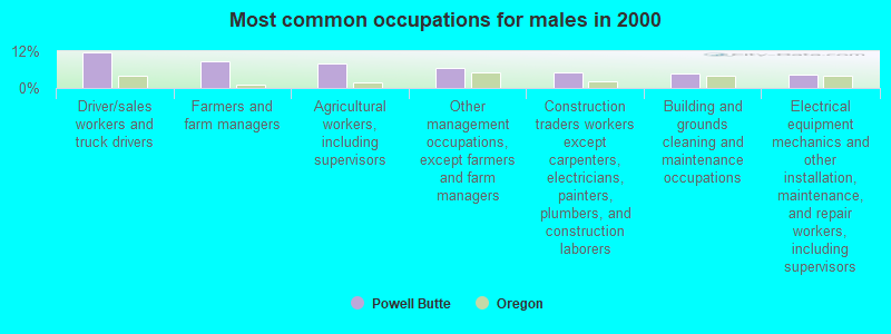
- Driver/sales workers and truck drivers (11.5%)
- Farmers and farm managers (8.7%)
- Agricultural workers, including supervisors (8.0%)
- Other management occupations, except farmers and farm managers (6.4%)
- Construction traders workers except carpenters, electricians, painters, plumbers, and construction laborers (5.0%)
- Building and grounds cleaning and maintenance occupations (4.9%)
- Electrical equipment mechanics and other installation, maintenance, and repair workers, including supervisors (4.3%)

- Preschool, kindergarten, elementary, and middle school teachers (11.9%)
- Secretaries and administrative assistants (10.6%)
- Other sales and related occupations, including supervisors (7.9%)
- Financial clerks, except bookkeeping, accounting and auditing clerks (6.2%)
- Bookkeeping, accounting, and auditing clerks (5.9%)
- Life, physical, and social science technicians (5.2%)
- Legal support workers (4.2%)
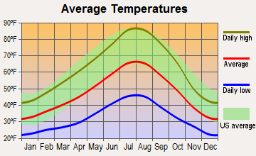
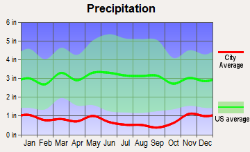
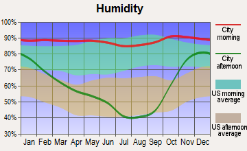
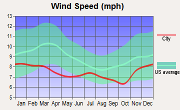
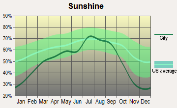
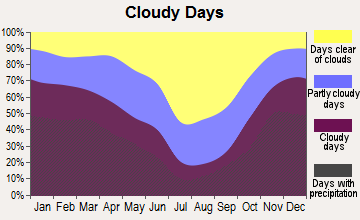
Average climate in Powell Butte, Oregon
Based on data reported by over 4,000 weather stations
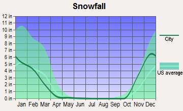
(lower is better)
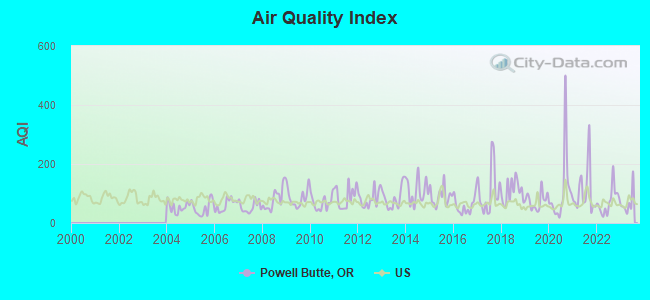
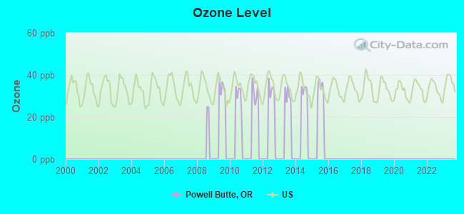
Air Quality Index (AQI) level in 2023 was 69.1. This is about average.
| City: | 69.1 |
| U.S.: | 72.6 |
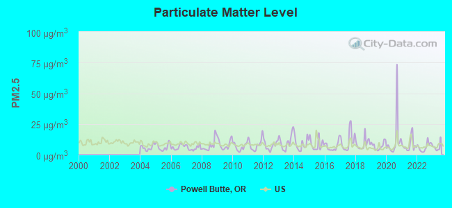
Particulate Matter (PM2.5) [µg/m3] level in 2023 was 6.24. This is better than average. Closest monitor was 9.4 miles away from the city center.
| City: | 6.24 |
| U.S.: | 8.11 |
Earthquake activity:
Powell Butte-area historical earthquake activity is significantly above Oregon state average. It is 2448% greater than the overall U.S. average.On 10/3/1915 at 06:52:48, a magnitude 7.6 (7.6 UK, Class: Major, Intensity: VIII - XII) earthquake occurred 315.9 miles away from the city center
On 1/31/1922 at 13:17:28, a magnitude 7.6 (7.6 UK) earthquake occurred 337.3 miles away from the city center
On 4/13/1949 at 19:55:42, a magnitude 7.0 (7.0 UK) earthquake occurred 219.1 miles away from the city center, causing $80,000,000 total damage
On 11/8/1980 at 10:27:34, a magnitude 7.2 (6.2 MB, 7.2 MS, 7.2 MW, 7.0 ML) earthquake occurred 273.9 miles away from Powell Butte center
On 2/28/2001 at 18:54:32, a magnitude 6.8 (6.5 MB, 6.6 MS, 6.8 MW, Class: Strong, Intensity: VII - IX) earthquake occurred 210.0 miles away from Powell Butte center, causing $2,000,000,000 total damage and $305,000,000 insured losses
On 2/28/2001 at 18:54:32, a magnitude 6.8 (6.8 MD, Depth: 32.2 mi) earthquake occurred 216.4 miles away from the city center
Magnitude types: body-wave magnitude (MB), duration magnitude (MD), local magnitude (ML), surface-wave magnitude (MS), moment magnitude (MW)
Natural disasters:
The number of natural disasters in Crook County (8) is smaller than the US average (15).Major Disasters (Presidential) Declared: 6
Emergencies Declared: 2
Causes of natural disasters: Floods: 4, Landslides: 2, Mudslides: 2, Winter Storms: 2, Drought: 1, Heavy Rain: 1, Hurricane: 1, Storm: 1, Other: 1 (Note: some incidents may be assigned to more than one category).
Hospitals and medical centers near Powell Butte:
- CODH HOME HEALTH AGENCY (Home Health Center, about 8 miles away; REDMOND, OR)
- ST CHARLES MEDICAL CENTER - REDMOND Acute Care Hospitals (about 8 miles away; REDMOND, OR)
- FRESENIUS MEDICAL CARE DIALYSIS SERVICES, OREGON, LLC (Dialysis Facility, about 9 miles away; REDMOND, OR)
- REDMOND HEALTH CARE CTR (Nursing Home, about 9 miles away; REDMOND, OR)
- OCHOCO CARE CENTER (Nursing Home, about 10 miles away; PRINEVILLE, OR)
- PIONEER MEMORIAL HOSPITAL Critical Access Hospitals (about 10 miles away; PRINEVILLE, OR)
- CROOK COUNTY NURSING HOME (Nursing Home, about 10 miles away; PRINEVILLE, OR)
Heliports located in Powell Butte:
Amtrak stations near Powell Butte:
- 9 miles: REDMOND (2456 S. US HWY. 97) - Bus Station . Services: snack bar, free short-term parking, intercity bus service.
- 19 miles: BEND (2045 US HWY 20) - Bus Station . Services: enclosed waiting area, public payphones, free short-term parking, call for car rental service, call for taxi service, intercity bus service.
Colleges/universities with over 2000 students nearest to Powell Butte:
- Central Oregon Community College (about 21 miles; Bend, OR; Full-time enrollment: 5,217)
- Lane Community College (about 102 miles; Eugene, OR; FT enrollment: 6,373)
- University of Oregon (about 103 miles; Eugene, OR; FT enrollment: 23,329)
- Linn-Benton Community College (about 106 miles; Albany, OR; FT enrollment: 4,511)
- Clackamas Community College (about 107 miles; Oregon City, OR; FT enrollment: 4,261)
- Chemeketa Community College (about 109 miles; Salem, OR; FT enrollment: 10,746)
- Willamette University (about 110 miles; Salem, OR; FT enrollment: 2,551)
Points of interest:
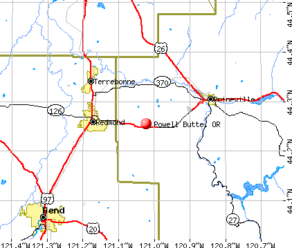
Notable locations in Powell Butte: Ponderosa Substation (A), Three Spring Ranch (B), Red Cloud Ranch (C), Crook County Fire and Rescue Powell Butte Station (D). Display/hide their locations on the map
Lakes and reservoirs: Houston Lake (A), Little Houston Lake (B), Shumway Lake (C). Display/hide their locations on the map
Rivers and creeks: Japanese Creek (A), Dry River (B), Lone Pine Creek (C). Display/hide their locations on the map
Drinking water stations with addresses in Powell Butte and their reported violations in the past:
POWELL BUTTE COUNTRY STORE INC (Population served: 125, Groundwater):Past monitoring violations:
- 2 routine major monitoring violations
- One regular monitoring violation
Drinking water stations with addresses in Powell Butte that have no violations reported:
- POWELL BUTTE CHRISTIAN CHURCH (Population served: 200, Primary Water Source Type: Groundwater)
| This place: | 2.4 people |
| Oregon: | 2.5 people |
| This place: | 79.5% |
| Whole state: | 63.4% |
| This place: | 3.7% |
| Whole state: | 8.0% |
Likely homosexual households (counted as self-reported same-sex unmarried-partner households)
- Lesbian couples: 0.3% of all households
- Gay men: 0.2% of all households
| This place: | 6.3% |
| Whole state: | 11.6% |
| This place: | 3.3% |
| Whole state: | 5.0% |
For population 15 years and over in Powell Butte:
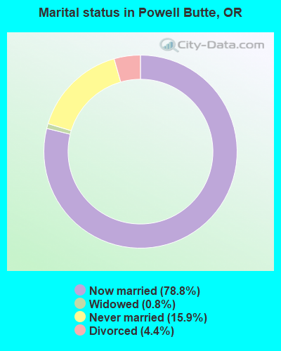
- Never married: 15.9%
- Now married: 78.8%
- Separated: 0.0%
- Widowed: 0.8%
- Divorced: 4.4%
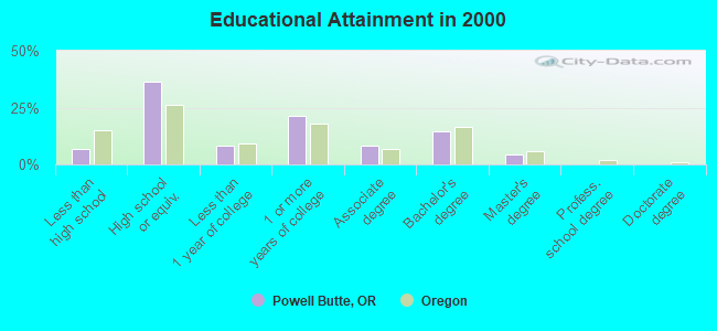
For population 25 years and over in Powell Butte:
- High school or higher: 93.1%
- Bachelor's degree or higher: 18.7%
- Graduate or professional degree: 4.2%
- Unemployed: 6.7%
- Mean travel time to work (commute): 21.0 minutes
| Here: | 8.3 |
| Oregon average: | 11.5 |
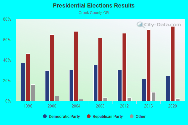
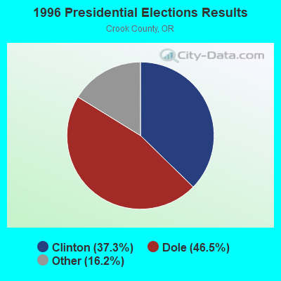
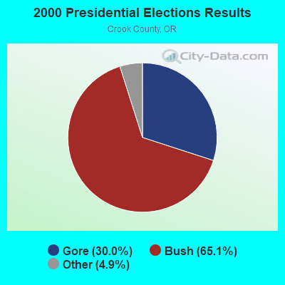
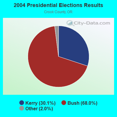
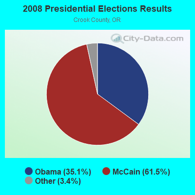

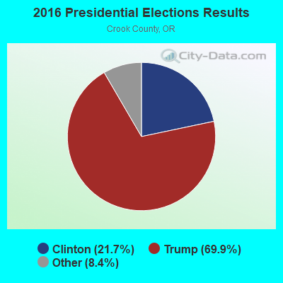
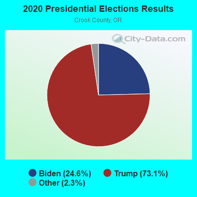
Graphs represent county-level data. Detailed 2008 Election Results
Religion statistics for Powell Butte, OR (based on Crook County data)
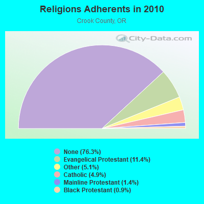
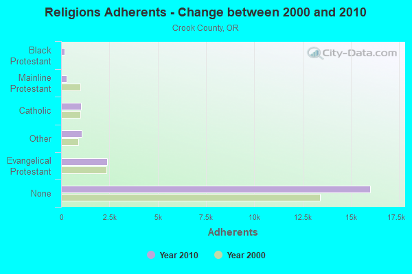
| Religion | Adherents | Congregations |
|---|---|---|
| Evangelical Protestant | 2,385 | 16 |
| Other | 1,079 | 3 |
| Catholic | 1,035 | 1 |
| Mainline Protestant | 285 | 3 |
| Black Protestant | 180 | 1 |
| None | 16,014 | - |
Food Environment Statistics:
| This county: | 2.63 / 10,000 pop. |
| Oregon: | 2.03 / 10,000 pop. |
| Crook County: | 0.44 / 10,000 pop. |
| Oregon: | 0.33 / 10,000 pop. |
| Crook County: | 1.31 / 10,000 pop. |
| State: | 2.01 / 10,000 pop. |
| Crook County: | 3.50 / 10,000 pop. |
| State: | 1.69 / 10,000 pop. |
| This county: | 7.88 / 10,000 pop. |
| Oregon: | 9.93 / 10,000 pop. |
| Crook County: | 8.1% |
| Oregon: | 7.4% |
| This county: | 29.9% |
| Oregon: | 25.6% |
| Here: | 12.1% |
| Oregon: | 14.2% |
Strongest AM radio stations in Powell Butte:
- KBND (1110 AM; 12 kW; BEND, OR; Owner: COMBINED COMMUNICATIONS, INC.)
- KICE (940 AM; 10 kW; BEND, OR; Owner: GCC BEND, LLC)
- KRCO (690 AM; 1 kW; PRINEVILLE, OR; Owner: HORIZON BROADCASTING GROUP LLC)
- KPOJ (620 AM; 50 kW; PORTLAND, OR; Owner: CITICASTERS LICENSES, L.P.)
- KXL (750 AM; 50 kW; PORTLAND, OR; Owner: ROSE CITY RADIO CORPORATION)
- KPNW (1120 AM; 50 kW; EUGENE, OR; Owner: CAPSTAR TX LIMITED PARTNERSHIP)
- KPAM (860 AM; 50 kW; TROUTDALE, OR; Owner: PAMPLIN BROADCASTING-OREGON, INC.)
- KOTK (1080 AM; 50 kW; PORTLAND, OR; Owner: FISHER BROADCASTING - PORTLAND RADIO, L.L.C.)
- KEX (1190 AM; 50 kW; PORTLAND, OR; Owner: CITICASTERS LICENSES, L.P.)
- KKSN (1520 AM; 50 kW; OREGON CITY, OR; Owner: ENTERCOM PORTLAND LICENSE, LLC)
- KKAD (1550 AM; 50 kW; VANCOUVER, WA; Owner: PAMPLIN BROADCASTING-WASHINGTON, INC)
- KDUN (1030 AM; 50 kW; REEDSPORT, OR; Owner: PAMPLIN BROADCASTING-OREGON, INC.)
- KGRV (700 AM; 25 kW; WINSTON, OR; Owner: PACIFIC CASCADE COMMUNICATIONS CORP.)
Strongest FM radio stations in Powell Butte:
- KWRX (88.5 FM; REDMOND, OR; Owner: ST BD OF HIGHER ED FOR THE UN OF OR)
- KMJZ-FM (95.1 FM; PRINEVILLE, OR; Owner: HORIZON BROADCASTING GROUP LLC)
- KSJJ (102.9 FM; REDMOND, OR; Owner: GCC BEND, LLC)
- K266AI (101.1 FM; BEND, OR; Owner: CALVARY CHAPEL OF TWIN FALLS, INC.)
- K205BJ (88.9 FM; BEND, OR; Owner: STATE OF OREGON(ACTING BY & THROUGH THE ST BD OF HIGHER EDU))
- KWPK-FM (104.1 FM; SISTERS, OR; Owner: THUNDEREGG WIRELESS, L.L.C.)
- KTWS (98.3 FM; BEND, OR; Owner: COMBINED COMMUNICATIONS, INC)
- KLRR (107.5 FM; REDMOND, OR; Owner: COMBINED COMMUNICATIONS, INC.)
- KQAK (105.7 FM; BEND, OR; Owner: HORIZON BROADCASTING GROUP, LLC)
- KMTK (99.7 FM; BEND, OR; Owner: COMBINED COMMUNICATIONS, INC.)
- KOAB-FM (91.3 FM; BEND, OR; Owner: OREGON PUBLIC BROADCASTING)
- KXIX (94.1 FM; BEND, OR; Owner: GCC BEND, LLC)
- KVLB (90.5 FM; BEND, OR; Owner: EDUCATIONAL MEDIA FOUNDATION)
- K208CV (89.5 FM; TUMALO, OR; Owner: EDUCATIONAL MEDIA FOUNDATION)
- KNLR (97.5 FM; BEND, OR; Owner: TERRY A. COWAN)
- KMGX (100.7 FM; BEND, OR; Owner: GCC BEND, LLC)
- KWLZ-FM (96.5 FM; WARM SPRINGS, OR; Owner: HORIZON BROADCASTING GROUP LLC)
- KWSO (91.9 FM; WARM SPRINGS, OR; Owner: CONFEDERATED TRIBES WARM SPRINGS REV)
TV broadcast stations around Powell Butte:
- K05HO (Channel 5; RILEY, OR; Owner: NPG OF OREGON, INC.)
- K29CI (Channel 29; PRINEVILLE, ETC., OR; Owner: FISHER BROADCASTING - PORTLAND TV, L.L.C.)
- K31CR (Channel 31; PRINEVILLE, ETC., OR; Owner: EMMIS TELEVISION LICENSE CORPORATION)
- KUBN-LP (Channel 50; BEND, OR; Owner: MEREDITH CORPORATION)
- K60BQ (Channel 60; TERREBONNE, OR; Owner: KING BROADCASTING COMPANY)
- K08KN (Channel 8; PRINEVILLE, ETC., OR; Owner: KING BROADCASTING COMPANY)
- KFXO-LP (Channel 39; BEND, OR; Owner: MEREDITH CORPORATION)
- KOAB-TV (Channel 3; BEND, OR; Owner: OREGON PUBLIC BROADCASTING)
- K27DO (Channel 27; BEND, ETC., OR; Owner: MEREDITH CORPORATION)
FCC Registered Antenna Towers:
16 (See the full list of FCC Registered Antenna Towers in Powell Butte)FCC Registered Broadcast Land Mobile Towers:
3- Lat: 44.164333 Lon: -121.046944, Call Sign: WQDT816,
Assigned Frequencies: 451.962 MHz, 451.887 MHz, 452.187 MHz, 452.537 MHz, 456.337 MHz, 457.487 MHz, 462.237 MHz, Grant Date: 10/28/2005, Expiration Date: 10/28/2015, Cancellation Date: 01/02/2016, Certifier: John Hassler, Registrant: Radio Licensing Services, Milwaukie, OR 97269-2161, Phone: (503) 794-3787, Fax: (503) 794-3759, Email:
- Lat: 44.286194 Lon: -121.046722, Call Sign: WQHE625,
Assigned Frequencies: 462.387 MHz, 467.387 MHz, 462.437 MHz, 467.437 MHz, Grant Date: 07/12/2007, Expiration Date: 07/12/2017, Cancellation Date: 09/16/2017, Certifier: Joseph Greytac, Registrant: Cara Enterprises Inc, Salt Lake City, UT 84117-0503, Phone: (801) 278-9728, Fax: (801) 278-7239, Email:
- Lat: 44.157056 Lon: -121.046639, Call Sign: WRYU706,
Assigned Frequencies: 452.187 MHz, 456.337 MHz, 457.487 MHz, 462.237 MHz, 451.962 MHz, 451.337 MHz, 451.637 MHz, 456.637 MHz, 457.187 MHz, 467.237 MHz, Grant Date: 09/19/2023, Expiration Date: 09/19/2033, Certifier: Aaron Oxenreider, Registrant: Radio Licensing Services, 4700 Se International Way, Milwaukie, OR 97269, Phone: (503) 659-1240, Email:
FCC Registered Microwave Towers:
33 (See the full list of FCC Registered Microwave Towers in this town)FCC Registered Paging Towers:
2 (See the full list of FCC Registered Paging Towers)FCC Registered Amateur Radio Licenses:
33 (See the full list of FCC Registered Amateur Radio Licenses in Powell Butte)FAA Registered Aircraft:
17 (See the full list of FAA Registered Aircraft in Powell Butte)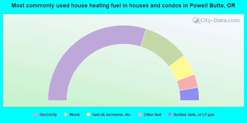
- 59.7%Electricity
- 19.8%Wood
- 9.2%Fuel oil, kerosene, etc.
- 5.7%Other fuel
- 5.6%Bottled, tank, or LP gas
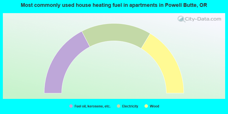
- 34.7%Fuel oil, kerosene, etc.
- 32.6%Electricity
- 32.6%Wood
Powell Butte compared to Oregon state average:
- Median house value above state average.
- Unemployed percentage below state average.
- Black race population percentage significantly below state average.
- Hispanic race population percentage significantly below state average.
- Median age above state average.
- Foreign-born population percentage significantly below state average.
- Renting percentage significantly below state average.
- Length of stay since moving in significantly above state average.
- Number of rooms per house significantly below state average.
- House age significantly below state average.
- Number of college students below state average.

|
|
Total of 19 patent applications in 2008-2024.