Poplar Top, Tennessee
Submit your own pictures of this place and show them to the world
- OSM Map
- General Map
- Google Map
- MSN Map

| Males: 1,810 | |
| Females: 1,807 |
| Median resident age: | 36.3 years |
| Tennessee median age: | 35.9 years |
Zip code: 38474
| Poplar Top: | $79,022 |
| TN: | $65,254 |
Estimated per capita income in 2022: $34,578 (it was $19,669 in 2000)
Poplar Top CCD income, earnings, and wages data
Estimated median house or condo value in 2022: $352,000 (it was $95,400 in 2000)
| Poplar Top: | $352,000 |
| TN: | $284,800 |
Detailed information about poverty and poor residents in Poplar Top, TN
Compare current foreclosures near Poplar Top, TN:
| Photo | Address | Area | Beds / Baths | Price | Details |
|---|---|---|---|---|---|

|
#1
Gulley Dr
Summertown, TN 38483
|
- sq. feet
|
2 baths 3 beds |
show details | |

|
#2
Highway 100
Centerville, TN 37033
|
1,325 sq. feet
|
2 baths 3 beds |
show details | |

|
#3
Columbia Ave
Centerville, TN 37033
|
2,116 sq. feet
|
2 baths 4 beds |
show details | |

|
#4
Florida Ave
Mount Pleasant, TN 38474
|
- sq. feet
|
1 baths 2 beds |
show details | |

|
#5
Zion Rd
Columbia, TN 38401
|
2,370 sq. feet
|
3 baths - beds |
show details | |

|
#6
Sioux Trl
Columbia, TN 38401
|
1,300 sq. feet
|
2 baths - beds |
show details | |

|
#7
Carters Creek Pike
Columbia, TN 38401
|
1,482 sq. feet
|
2 baths - beds |
show details | |

|
#8
W 17th St
Columbia, TN 38401
|
744 sq. feet
|
1 baths - beds |
show details | |

|
#9
Mount Olivet Rd
Columbia, TN 38401
|
3,784 sq. feet
|
3 baths - beds |
show details | |

|
#10
Campbellsville Rd
Lynnville, TN 38472
|
812 sq. feet
|
1 baths - beds |
show details |
| Photo | Address | Area | Beds / Baths | Price | Details |
|---|---|---|---|---|---|

|
#11
Cornelia Dr
Columbia, TN 38401
|
1,225 sq. feet
|
1 baths - beds |
show details | |

|
#12
Cardinal Way
Summertown, TN 38483
|
1,484 sq. feet
|
2 baths - beds |
show details | |

|
#13
Mckenzie Ln
Summertown, TN 38483
|
1,548 sq. feet
|
2 baths - beds |
show details | |

|
#14
Iron Bridge Rd
Columbia, TN 38401
|
1,149 sq. feet
|
1 baths - beds |
show details | |

|
#15
Parker St
Columbia, TN 38401
|
1,122 sq. feet
|
1 baths - beds |
show details | |

|
#16
Carters Creek Pike
Columbia, TN 38401
|
1,512 sq. feet
|
2 baths - beds |
show details | |

|
#17
Highland Ave
Columbia, TN 38401
|
744 sq. feet
|
1 baths - beds |
show details | |

|
#18
E Valley Dr
Columbia, TN 38401
|
729 sq. feet
|
1 baths - beds |
show details | |

|
#19
Whitney Dr
Columbia, TN 38401
|
2,246 sq. feet
|
2 baths - beds |
show details | |

|
#20
Highland Ave
Columbia, TN 38401
|
1,583 sq. feet
|
2 baths - beds |
show details |
| Photo | Address | Area | Beds / Baths | Price | Details |
|---|---|---|---|---|---|

|
#21
Hemingway Dr
Columbia, TN 38401
|
1,862 sq. feet
|
1 baths - beds |
show details | |

|
#22
Indian Creek Rd
Hohenwald, TN 38462
|
1,849 sq. feet
|
2 baths - beds |
show details | |

|
#23
Gene Fitzgerald Rd
Columbia, TN 38401
|
972 sq. feet
|
2 baths - beds |
show details | |

|
#24
Richmond Rd
Columbia, TN 38401
|
1,105 sq. feet
|
1 baths - beds |
show details | |

|
#25
Trousdale Ln
Columbia, TN 38401
|
1,344 sq. feet
|
2 baths - beds |
show details | |

|
#26
Trousdale Ln
Columbia, TN 38401
|
1,882 sq. feet
|
2 baths - beds |
show details | |

|
#27
Darden Pl
Columbia, TN 38401
|
1,352 sq. feet
|
1 baths - beds |
show details | |

|
#28
Deerview Dr
Columbia, TN 38401
|
1,940 sq. feet
|
2 baths - beds |
show details | |

|
#29
Lenape Path
Columbia, TN 38401
|
1,960 sq. feet
|
2 baths - beds |
show details | |

|
#30
Riverside Dr
Centerville, TN 37033
|
2,099 sq. feet
|
2 baths - beds |
show details |
| Photo | Address | Area | Beds / Baths | Price | Details |
|---|---|---|---|---|---|

|
#31
Shenandoah Dr
Columbia, TN 38401
|
1,325 sq. feet
|
2 baths - beds |
show details | |

|
#32
Cumberland Dr
Columbia, TN 38401
|
1,300 sq. feet
|
1 baths - beds |
show details | |

|
#33
Blackwood Dr
Summertown, TN 38483
|
1,456 sq. feet
|
1 baths - beds |
show details | |

|
#34
Scribner Ave
Columbia, TN 38401
|
1,278 sq. feet
|
1 baths - beds |
show details | |

|
#35
Autumn Ridge Ln
Columbia, TN 38401
|
1,804 sq. feet
|
3 baths - beds |
show details | |

|
#36
W Sheepneck Rd
Mount Pleasant, TN 38474
|
984 sq. feet
|
1 baths - beds |
show details | |

|
#37
Hampshire Pike
Hampshire, TN 38461
|
1,484 sq. feet
|
3 baths - beds |
show details | |

|
#38
Woodmont Dr
Columbia, TN 38401
|
1,040 sq. feet
|
1 baths - beds |
show details | |

|
#39
Edge Park Ct
Columbia, TN 38401
|
1,230 sq. feet
|
2 baths - beds |
show details | |

|
#40
Brookview Cir
Columbia, TN 38401
|
1,189 sq. feet
|
2 baths - beds |
show details |
| Photo | Address | Area | Beds / Baths | Price | Details |
|---|---|---|---|---|---|

|
#41
Galloway St
Columbia, TN 38401
|
1,736 sq. feet
|
1 baths - beds |
show details | |

|
#42
Smith Hollow Rd
Mount Pleasant, TN 38474
|
1,008 sq. feet
|
2 baths - beds |
show details | |

|
#43
Lee Dr
Columbia, TN 38401
|
2,118 sq. feet
|
1 baths - beds |
show details | |

|
#44
1/2 Wheeler Dr
Columbia, TN 38401
|
1,300 sq. feet
|
1 baths - beds |
show details | |

|
#45
Tommy Dr
Columbia, TN 38401
|
1,178 sq. feet
|
2 baths - beds |
show details | |

|
#46
W Sheepneck Rd
Mount Pleasant, TN 38474
|
984 sq. feet
|
2 baths - beds |
show details | |

|
#47
Pinehurst Dr
Columbia, TN 38401
|
1,360 sq. feet
|
2 baths - beds |
show details | |

|
#48
Avra Ct
Columbia, TN 38401
|
1,194 sq. feet
|
2 baths - beds |
show details | |

|
#49
W 15th St
Columbia, TN 38401
|
948 sq. feet
|
1 baths - beds |
show details | |

|
Check over 1 million property listings on Foreclosure.com!
|
browse all offers | |||

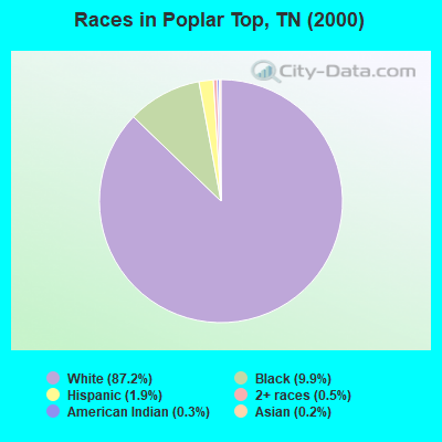
- 2,73387.2%White alone
- 3109.9%Black alone
- 581.9%Hispanic
- 170.5%Two or more races
- 90.3%American Indian alone
- 60.2%Asian alone
- 20.06%Other race alone
Races in Poplar Top detailed stats: ancestries, foreign born residents, place of birth
 Recent articles from our blog. Our writers, many of them Ph.D. graduates or candidates, create easy-to-read articles on a wide variety of topics.
Current Local Time: CST time zone
Elevation: 680 feet
Land area: 79.8 square miles.
Population density: 45 people per square mile (very low).

| Poplar Top CCD: | 0.5% ($511) |
| Tennessee: | 0.8% ($715) |
Nearest city with pop. 50,000+: Metropolitan Government, TN  (44.8 miles , pop. 569,891).
Nearest city with pop. 1,000,000+: Chicago, IL (429.8 miles , pop. 2,896,016).
Nearest cities:
), ), ), ), ), Latitude: 35.64 N, Longitude: 87.24 W
Area code commonly used in this area: 931

| Here: | 2.5% |
| Tennessee: | 3.0% |
- Transportation equipment (13.3%)
- Health care (11.4%)
- Construction (8.2%)
- Finance & insurance (5.4%)
- Educational services (5.1%)
- Truck transportation (3.5%)
- Accommodation & food services (3.3%)
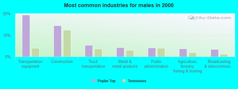
- Transportation equipment (19.4%)
- Construction (14.4%)
- Truck transportation (5.4%)
- Metal & metal products (4.3%)
- Public administration (4.1%)
- Agriculture, forestry, fishing & hunting (3.8%)
- Broadcasting & telecommunications (3.4%)
- Health care (22.9%)
- Educational services (11.8%)
- Finance & insurance (9.5%)
- Accommodation & food services (7.7%)
- Transportation equipment (5.0%)
- Miscellaneous manufacturing (3.6%)
- Department & other general merchandise stores (3.4%)
- Assemblers and fabricators (7.3%)
- Driver/sales workers and truck drivers (5.4%)
- Other office and administrative support workers, including supervisors (4.8%)
- Electrical equipment mechanics and other installation, maintenance, and repair workers, including supervisors (4.4%)
- Other production occupations, including supervisors (3.9%)
- Metal workers and plastic workers (3.9%)
- Laborers and material movers, hand (3.8%)
- Assemblers and fabricators (10.1%)
- Driver/sales workers and truck drivers (9.4%)
- Electrical equipment mechanics and other installation, maintenance, and repair workers, including supervisors (7.7%)
- Metal workers and plastic workers (6.8%)
- Vehicle and mobile equipment mechanics, installers, and repairers (6.0%)
- Other production occupations, including supervisors (5.5%)
- Construction traders workers except carpenters, electricians, painters, plumbers, and construction laborers (4.7%)

- Other office and administrative support workers, including supervisors (8.9%)
- Secretaries and administrative assistants (8.3%)
- Cooks and food preparation workers (8.0%)
- Health technologists and technicians (6.5%)
- Preschool, kindergarten, elementary, and middle school teachers (5.2%)
- Customer service representatives (5.2%)
- Laborers and material movers, hand (5.0%)
Average climate in Poplar Top, Tennessee
Based on data reported by over 4,000 weather stations


(lower is better)
Air Quality Index (AQI) level in 2022 was 63.8. This is about average.
| City: | 63.8 |
| U.S.: | 72.6 |
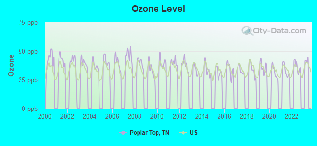
Ozone [ppb] level in 2022 was 36.9. This is about average. Closest monitor was 6.8 miles away from the city center.
| City: | 36.9 |
| U.S.: | 33.3 |
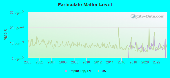
Particulate Matter (PM2.5) [µg/m3] level in 2022 was 6.82. This is about average. Closest monitor was 13.0 miles away from the city center.
| City: | 6.82 |
| U.S.: | 8.11 |
Tornado activity:
Poplar Top-area historical tornado activity is slightly above Tennessee state average. It is 83% greater than the overall U.S. average.
On 4/16/1998, a category F5 (max. wind speeds 261-318 mph) tornado 20.1 miles away from the Poplar Top place center killed 3 people and injured 36 people and caused $13 million in damages.
On 5/18/1995, a category F4 (max. wind speeds 207-260 mph) tornado 20.2 miles away from the place center killed 3 people and injured 32 people and caused between $500,000 and $5,000,000 in damages.
Earthquake activity:
Poplar Top-area historical earthquake activity is significantly above Tennessee state average. It is 220% greater than the overall U.S. average.On 4/18/2008 at 09:36:59, a magnitude 5.4 (5.1 MB, 4.8 MS, 5.4 MW, 5.2 MW, Class: Moderate, Intensity: VI - VII) earthquake occurred 198.0 miles away from Poplar Top center
On 4/29/2003 at 08:59:39, a magnitude 4.9 (4.4 MB, 4.6 MW, 4.9 LG, Class: Light, Intensity: IV - V) earthquake occurred 120.7 miles away from Poplar Top center
On 4/18/2008 at 09:36:59, a magnitude 5.2 (5.2 MW, Depth: 8.9 mi) earthquake occurred 197.9 miles away from the city center
On 5/4/1991 at 01:18:54, a magnitude 5.0 (4.4 MB, 4.6 LG, 5.0 LG, Depth: 3.1 mi) earthquake occurred 157.9 miles away from the city center
On 6/18/2002 at 17:37:15, a magnitude 5.0 (4.3 MB, 4.6 MW, 5.0 LG) earthquake occurred 165.3 miles away from the city center
On 9/26/1990 at 13:18:51, a magnitude 5.0 (4.7 MB, 4.8 LG, 5.0 LG, Depth: 7.7 mi) earthquake occurred 165.9 miles away from the city center
Magnitude types: regional Lg-wave magnitude (LG), body-wave magnitude (MB), surface-wave magnitude (MS), moment magnitude (MW)
Natural disasters:
The number of natural disasters in Maury County (14) is near the US average (15).Major Disasters (Presidential) Declared: 12
Emergencies Declared: 1
Causes of natural disasters: Storms: 10, Floods: 9, Tornadoes: 7, Winds: 4, Flash Flood: 1, Heavy Rain: 1, Hurricane: 1, Ice Storm: 1, Winter Storm: 1, Other: 1 (Note: some incidents may be assigned to more than one category).
Hospitals and medical centers near Poplar Top:
- HIDDEN ACRES (Nursing Home, about 7 miles away; MOUNT PLEASANT, TN)
- MT PLEASANT HEALTH AND REHABILITATION (Nursing Home, about 7 miles away; MOUNT PLEASANT, TN)
- LEWIS COUNTY NURSING AND REHABILITATION CENTER (Nursing Home, about 8 miles away; HOHENWALD, TN)
- HILLVIEW HEALTH CARE CENTER INC (Nursing Home, about 10 miles away; COLUMBIA, TN)
- NHC HEALTHCARE, COLUMBIA (Nursing Home, about 10 miles away; COLUMBIA, TN)
- HERITAGE MANOR OF COLUMBIA (Nursing Home, about 10 miles away; COLUMBIA, TN)
- SIGNATURE HEALTHCARE OF COLUMBIA (Nursing Home, about 10 miles away; COLUMBIA, TN)
Colleges/universities with over 2000 students nearest to Poplar Top:
- Columbia State Community College (about 8 miles; Columbia, TN; Full-time enrollment: 3,383)
- Nashville State Community College (about 41 miles; Nashville, TN; FT enrollment: 6,436)
- Lipscomb University (about 41 miles; Nashville, TN; FT enrollment: 3,827)
- Belmont University (about 43 miles; Nashville, TN; FT enrollment: 5,795)
- Vanderbilt University (about 43 miles; Nashville, TN; FT enrollment: 10,518)
- Tennessee State University (about 44 miles; Nashville, TN; FT enrollment: 7,341)
- Trevecca Nazarene University (about 45 miles; Nashville, TN; FT enrollment: 2,223)
Points of interest:
Notable locations in Poplar Top: Cross Bridges (A), Century (B), Sheboss Place (C), Monsanto (D), Williamsport Volunteer Fire Department (E), Hampshire Fire Department Station 5 (F). Display/hide their locations on the map
Churches in Poplar Top include: Mount Nebo Church (A), South Point Church (B), Kettle Church (C), Viola Church (D), West Point Church (E), Pleasant Union Church (F), Pisgah Church (G), Catheys Creek Church (H), New Zion Church (I). Display/hide their locations on the map
Cemeteries: Jones Cemetery (1), Webster Cemetery (2), White Cemetery (3), Kittrell Cemetery (4), Williamsport Cemetery (5), Strayhorn Cemetery (6), Pisgah Cemetery (7). Display/hide their locations on the map
Lakes and reservoirs: Burcham Pond (A), Tailings Pond Number Two (B), Tailings Pond Number Ten (C), Tailings Pond Number Eight (D), Tailings Pond Number Nine (E), Tailings Pond Number Twelve (F), Tailings Pond Number Eleven (G), Tailings Pond Number Three (H). Display/hide their locations on the map
Streams, rivers, and creeks: Lusk Branch (A), Loves Branch (B), Big Bigby Creek (C), Beard Branch (D), Kettle Branch (E), Jones Branch (F), John Branch (G), Helms Branch (H), Harlan Branch (I). Display/hide their locations on the map
| This place: | 2.8 people |
| Tennessee: | 2.5 people |
| This place: | 69.8% |
| Whole state: | 69.8% |
| This place: | 3.9% |
| Whole state: | 4.2% |
Likely homosexual households (counted as self-reported same-sex unmarried-partner households)
- Lesbian couples: 0.4% of all households
- Gay men: 0.2% of all households
| This place: | 7.9% |
| Whole state: | 13.5% |
| This place: | 2.8% |
| Whole state: | 5.8% |
For population 15 years and over in Poplar Top:
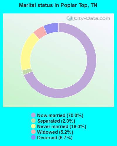
- Never married: 18.0%
- Now married: 70.0%
- Separated: 2.0%
- Widowed: 5.2%
- Divorced: 6.7%
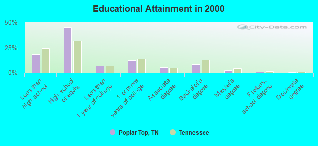
For population 25 years and over in Poplar Top:
- High school or higher: 81.4%
- Bachelor's degree or higher: 11.9%
- Graduate or professional degree: 3.6%
- Unemployed: 3.6%
- Mean travel time to work (commute): 29.8 minutes

| Here: | 10.2 |
| Tennessee average: | 13.3 |
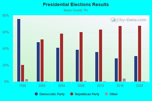
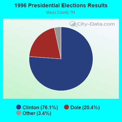
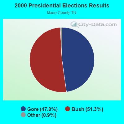


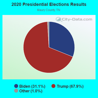
Graphs represent county-level data. Detailed 2008 Election Results
Religion statistics for Poplar Top, TN (based on Maury County data)

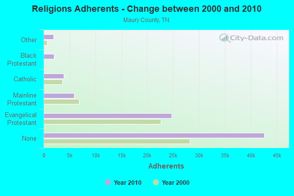
| Religion | Adherents | Congregations |
|---|---|---|
| Evangelical Protestant | 24,645 | 136 |
| Mainline Protestant | 5,864 | 31 |
| Catholic | 3,900 | 2 |
| Black Protestant | 2,029 | 14 |
| Other | 1,915 | 7 |
| None | 42,603 | - |
Food Environment Statistics:
| This county: | 2.01 / 10,000 pop. |
| Tennessee: | 1.99 / 10,000 pop. |
| Here: | 0.25 / 10,000 pop. |
| Tennessee: | 0.65 / 10,000 pop. |
| Maury County: | 6.89 / 10,000 pop. |
| Tennessee: | 5.16 / 10,000 pop. |
| This county: | 6.64 / 10,000 pop. |
| Tennessee: | 6.56 / 10,000 pop. |
| Maury County: | 10.8% |
| State: | 11.4% |
| This county: | 31.4% |
| Tennessee: | 30.2% |
| Maury County: | 13.6% |
| State: | 13.5% |
Strongest AM radio stations in Poplar Top:
- WSM (650 AM; 50 kW; NASHVILLE, TN; Owner: GAYLORD ENTERTAINMENT COMPANY)
- WKDA (1200 AM; 50 kW; NASHVILLE, TN; Owner: RADIO NASHVILLE, INC.)
- WNQM (1300 AM; 50 kW; NASHVILLE, TN; Owner: WNQM. INC.)
- WAMB (1160 AM; 50 kW; DONELSON, TN; Owner: GREAT SOUTHERN BROADCASTING COMPANY, INC.)
- WMCP (1280 AM; 5 kW; COLUMBIA, TN; Owner: MAURY COUNTY BOOSTERS CORP.)
- WNKX (1570 AM; 5 kW; CENTERVILLE, TN; Owner: HICKMAN COUNTY BROADCASTING CO., INC.)
- WLAC (1510 AM; 50 kW; NASHVILLE, TN; Owner: CAPSTAR TX LIMITED PARTNERSHIP)
- WXRQ (1460 AM; 1 kW; MOUNT PLEASANT, TN; Owner: NEW LIFE BROADCASTING, INC.)
- WLOR (1550 AM; 50 kW; HUNTSVILLE, AL; Owner: BCA RADIO, LLC)
- WKRM (1340 AM; 1 kW; COLUMBIA, TN; Owner: MIDDLE TENN. BROADCASTING CO., INC.)
- WWAM (820 AM; daytime; 50 kW; JASPER, TN; Owner: SHELTON BROADCASTING SYSTEM)
- WHEW (1380 AM; 5 kW; FRANKLIN, TN; Owner: SG COMMUNICATIONS, INC.)
- WAKM (950 AM; 5 kW; FRANKLIN, TN; Owner: FRANKLIN RADIO ASSOCIATES, INC.)
Strongest FM radio stations in Poplar Top:
- WKOM (101.7 FM; COLUMBIA, TN; Owner: MIDDLE TENN. BROADCASTING COMPANY)
- WKDF (103.3 FM; NASHVILLE, TN; Owner: CITADEL BROADCASTING COMPANY)
- WNRQ (105.9 FM; NASHVILLE, TN; Owner: CAPSTAR TX LIMITED PARTNERSHIP)
- WRLT (100.1 FM; FRANKLIN, TN; Owner: TUNED-IN BROADCASTING, INC)
- WPLN-FM (90.3 FM; NASHVILLE, TN; Owner: NASHVILLE PUBLIC RADIO)
- WSIX-FM (97.9 FM; NASHVILLE, TN; Owner: CAPSTAR TX LIMITED PARTNERSHIP)
- W264AD (100.7 FM; COLUMBIA, TN; Owner: WEATHER RADIO ASSOCIATE)
- WAYM (88.7 FM; COLUMBIA, TN; Owner: WAY-FM MEDIA GROUP, INC.)
- WSM-FM (95.5 FM; NASHVILLE, TN; Owner: CUMULUS LICENSING CORP.)
- WFCM-FM (91.7 FM; MURFREESBORO, TN; Owner: THE MOODY BIBLE INSTITUTE OF CHICAGO)
- WJXA (92.9 FM; NASHVILLE, TN; Owner: SOUTH CENTRAL COMMUNICATIONS CORP.)
- WBUZ (102.9 FM; LA VERGNE, TN; Owner: WYCQ, INC)
- WGFX (104.5 FM; GALLATIN, TN; Owner: CITADEL BROADCASTING COMPANY)
- WMAK (96.3 FM; MURFREESBORO, TN; Owner: SOUTH CENTRAL COMMUNICATIONS CORP.)
- WWTN (99.7 FM; MANCHESTER, TN; Owner: CUMULUS LICENSING CORP.)
- WFGZ (94.5 FM; LOBELVILLE, TN; Owner: OHIO BROADCAST ASSOCIATES)
- WFFI (93.7 FM; KINGSTON SPRINGS, TN; Owner: CARON BROADCASTING, INC.)
- WLLX (97.5 FM; LAWRENCEBURG, TN; Owner: ROGER WRIGHT DBA PROSPECT COMMUNICATIONS)
- W287AA (105.3 FM; LAWRENCEBURG, TN; Owner: WAY-FM MEDIA GROUP, INC.)
- WAUO (90.7 FM; HOHENWALD, TN; Owner: AMERICAN FAMILY ASSOCIATION)
TV broadcast stations around Poplar Top:
- WNAB (Channel 58; NASHVILLE, TN; Owner: NASHVILLE LICENSE HOLDINGS, L.L.C.)
- WKRN-TV (Channel 2; NASHVILLE, TN; Owner: WKRN, G.P.)
- WSMV-TV (Channel 4; NASHVILLE, TN; Owner: MEREDITH CORPORATION)
- WZTV (Channel 17; NASHVILLE, TN; Owner: WZTV LICENSEE, LLC)
- WNPT (Channel 8; NASHVILLE, TN; Owner: NASHVILLE PUBLIC TELEVISION, INC.)
- W10BV (Channel 10; LAWRENCEBURG, TN; Owner: ETC COMMUNICATIONS INC.)
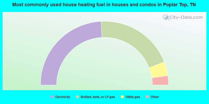
- 48.3%Electricity
- 39.9%Bottled, tank, or LP gas
- 7.1%Utility gas
- 2.7%Wood
- 1.3%Fuel oil, kerosene, etc.
- 0.7%No fuel used
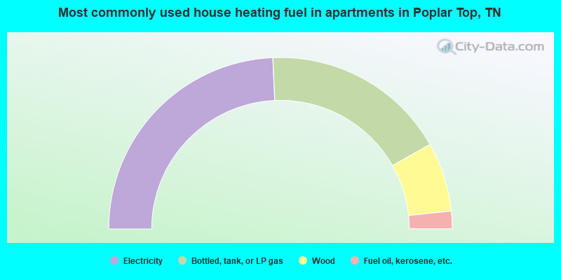
- 48.6%Electricity
- 35.0%Bottled, tank, or LP gas
- 13.1%Wood
- 3.3%Fuel oil, kerosene, etc.
Poplar Top compared to Tennessee state average:
- Unemployed percentage significantly below state average.
- Hispanic race population percentage significantly below state average.
- Foreign-born population percentage significantly below state average.
- Renting percentage significantly below state average.
- Length of stay since moving in significantly above state average.
- Number of rooms per house significantly below state average.
- House age significantly below state average.
- Number of college students below state average.
- Percentage of population with a bachelor's degree or higher below state average.