Perham, Maine
Submit your own pictures of this town and show them to the world
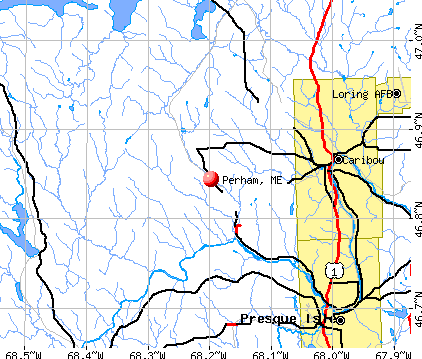
- OSM Map
- General Map
- Google Map
- MSN Map
Population change since 2000: -11.1%
 |
| Males: 197 | |
| Females: 189 |
| Median resident age: | 45.3 years |
| Maine median age: | 43.0 years |
Zip codes: 04766.
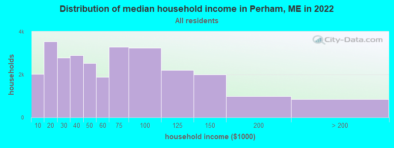
| Perham: | $46,271 |
| ME: | $69,543 |
Estimated per capita income in 2022: $24,190 (it was $11,721 in 2000)
Perham town income, earnings, and wages data
Estimated median house or condo value in 2022: $140,432 (it was $58,000 in 2000)
| Perham: | $140,432 |
| ME: | $290,600 |
Mean prices in 2022: all housing units: $179,108; detached houses: $185,023; townhouses or other attached units: $218,327; in 2-unit structures: $262,505; in 3-to-4-unit structures: $121,406; in 5-or-more-unit structures: $185,084; mobile homes: $117,009; occupied boats, rvs, vans, etc.: $12,682
Detailed information about poverty and poor residents in Perham, ME


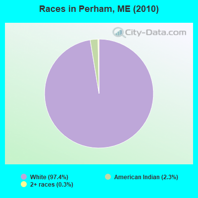
- 37697.4%White alone
- 92.3%American Indian alone
- 10.3%Two or more races
Races in Perham detailed stats: ancestries, foreign born residents, place of birth
According to our research of Maine and other state lists, there were 2 registered sex offenders living in Perham, Maine as of May 09, 2024.
The ratio of all residents to sex offenders in Perham is 193 to 1.
 Recent articles from our blog. Our writers, many of them Ph.D. graduates or candidates, create easy-to-read articles on a wide variety of topics.

 | Why Does Northern Maine Feel So Different Than The Rest Of The Northeast? (90 replies) |
| Does Maine appeal to any young people these days? (108 replies) |
| Possibly relocating to Maine from Texas, Buying Land, etc... (102 replies) |
| Maine humorist Joe Perham dies (1 reply) |
| Homesick (51 replies) |
| You Know You're in Maine When... (108 replies) |
Latest news from Perham, ME collected exclusively by city-data.com from local newspapers, TV, and radio stations
Ancestries: French (27.2%), English (24.9%), Irish (16.6%), Swedish (14.7%), German (7.8%), Scottish (6.2%).
Current Local Time: EST time zone
Incorporated on 03/26/1897
Elevation: 630 feet
Land area: 36.5 square miles.
Population density: 11 people per square mile (very low).
18 residents are foreign born (2.5% Europe, 1.6% North America).
| This town: | 4.1% |
| Maine: | 2.9% |
| Perham town: | 1.1% ($643) |
| Maine: | 1.5% ($1,417) |
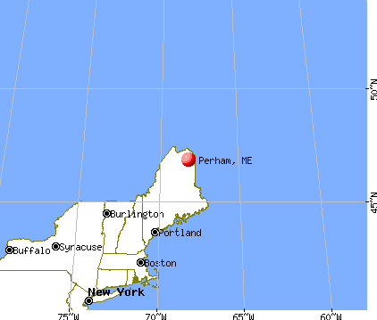
Nearest city with pop. 50,000+: Portland, ME  (244.4 miles , pop. 64,249).
Nearest city with pop. 200,000+: Boston, MA (346.2 miles , pop. 589,141).
Nearest city with pop. 1,000,000+: Bronx, NY (504.0 miles , pop. 1,332,650).
Nearest cities:
), ), ), ), Latitude: 46.89 N, Longitude: 68.22 W
Area code commonly used in this area: 207

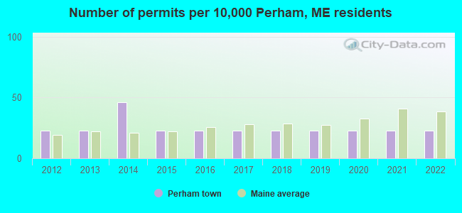
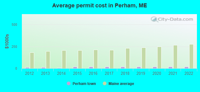
Single-family new house construction building permits:
- 2022: 1 building, cost: $22,000
- 2021: 1 building, cost: $22,000
- 2020: 1 building, cost: $22,000
- 2019: 1 building, cost: $22,000
- 2018: 1 building, cost: $22,000
- 2017: 1 building, cost: $22,000
- 2016: 1 building, cost: $22,000
- 2015: 1 building, cost: $22,000
- 2014: 2 buildings, average cost: $7,500
- 2013: 1 building, cost: $15,000
- 2012: 1 building, cost: $15,000
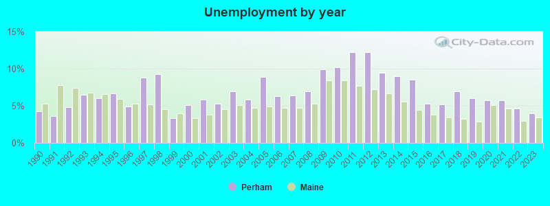
| Here: | 4.0% |
| Maine: | 3.4% |
- Health care (19.6%)
- Agriculture, forestry, fishing & hunting (14.1%)
- Accommodation & food services (8.0%)
- Construction (6.7%)
- Motor vehicle & parts dealers (4.3%)
- Wood products (3.7%)
- U. S. Postal service (3.1%)
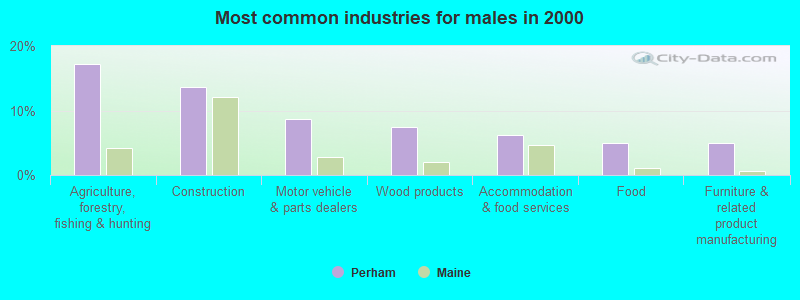
- Agriculture, forestry, fishing & hunting (17.3%)
- Construction (13.6%)
- Motor vehicle & parts dealers (8.6%)
- Wood products (7.4%)
- Accommodation & food services (6.2%)
- Food (4.9%)
- Furniture & related product manufacturing (4.9%)
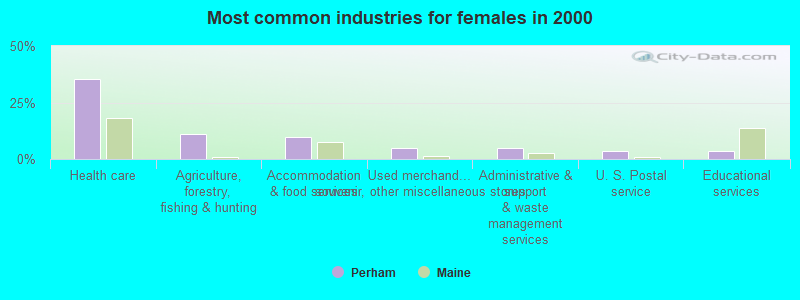
- Health care (35.4%)
- Agriculture, forestry, fishing & hunting (11.0%)
- Accommodation & food services (9.8%)
- Used merchandise, gift, novelty, souvenir, other miscellaneous stores (4.9%)
- Administrative & support & waste management services (4.9%)
- U. S. Postal service (3.7%)
- Educational services (3.7%)
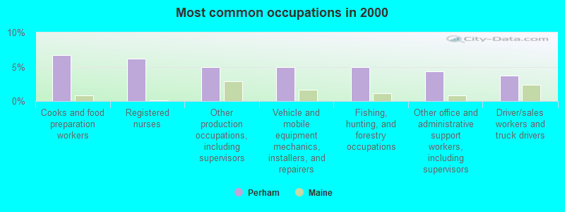
- Cooks and food preparation workers (6.7%)
- Registered nurses (6.1%)
- Other production occupations, including supervisors (4.9%)
- Vehicle and mobile equipment mechanics, installers, and repairers (4.9%)
- Fishing, hunting, and forestry occupations (4.9%)
- Other office and administrative support workers, including supervisors (4.3%)
- Driver/sales workers and truck drivers (3.7%)
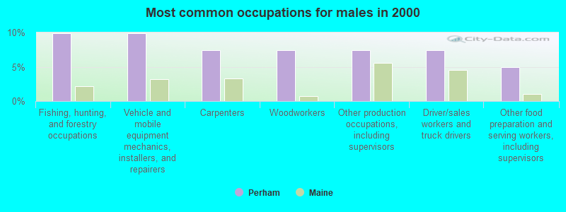
- Fishing, hunting, and forestry occupations (9.9%)
- Vehicle and mobile equipment mechanics, installers, and repairers (9.9%)
- Carpenters (7.4%)
- Woodworkers (7.4%)
- Other production occupations, including supervisors (7.4%)
- Driver/sales workers and truck drivers (7.4%)
- Other food preparation and serving workers, including supervisors (4.9%)
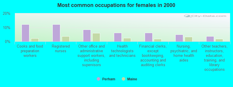
- Cooks and food preparation workers (12.2%)
- Registered nurses (12.2%)
- Other office and administrative support workers, including supervisors (8.5%)
- Health technologists and technicians (6.1%)
- Financial clerks, except bookkeeping, accounting and auditing clerks (6.1%)
- Nursing, psychiatric, and home health aides (4.9%)
- Other teachers, instructors, education, training, and library occupations (3.7%)
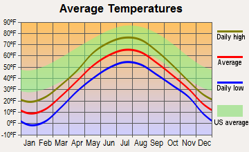
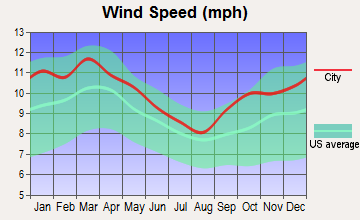
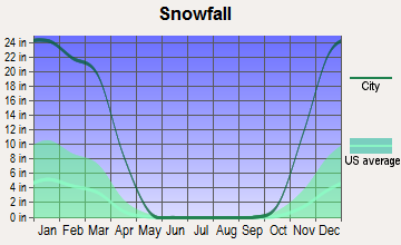
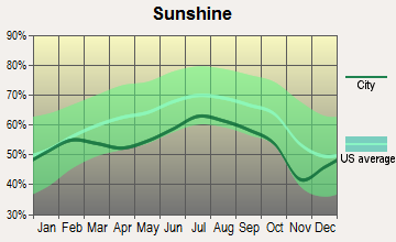
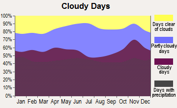
Average climate in Perham, Maine
Based on data reported by over 4,000 weather stations
(lower is better)
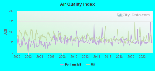
Air Quality Index (AQI) level in 2023 was 79.3. This is about average.
| City: | 79.3 |
| U.S.: | 72.6 |
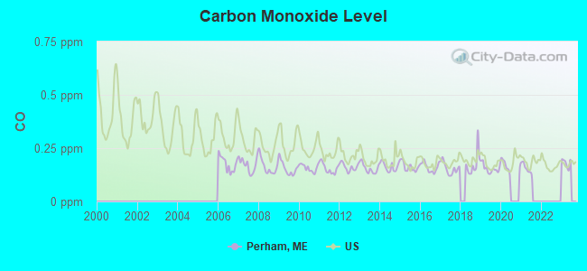
Carbon Monoxide (CO) [ppm] level in 2021 was 0.155. This is significantly better than average. Closest monitor was 16.1 miles away from the city center.
| City: | 0.155 |
| U.S.: | 0.251 |
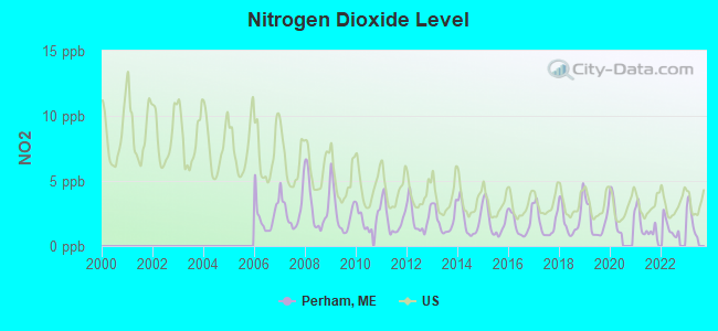
Nitrogen Dioxide (NO2) [ppb] level in 2022 was 1.41. This is significantly better than average. Closest monitor was 16.1 miles away from the city center.
| City: | 1.41 |
| U.S.: | 5.11 |
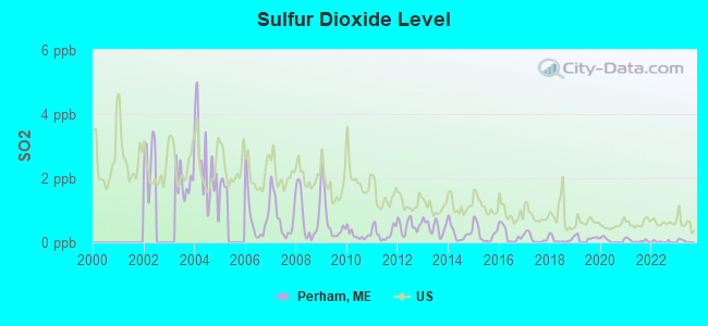
Sulfur Dioxide (SO2) [ppb] level in 2022 was 0.0234. This is significantly better than average. Closest monitor was 16.1 miles away from the city center.
| City: | 0.0234 |
| U.S.: | 1.5147 |
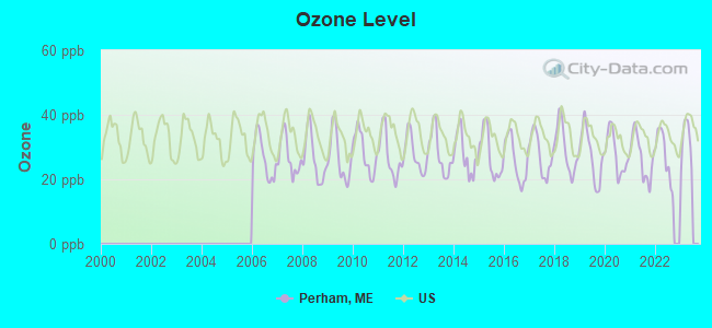
Ozone [ppb] level in 2022 was 27.5. This is better than average. Closest monitor was 9.8 miles away from the city center.
| City: | 27.5 |
| U.S.: | 33.3 |
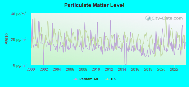
Particulate Matter (PM10) [µg/m3] level in 2023 was 19.0. This is about average. Closest monitor was 15.8 miles away from the city center.
| City: | 19.0 |
| U.S.: | 19.2 |
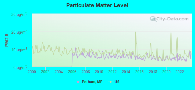
Particulate Matter (PM2.5) [µg/m3] level in 2023 was 6.39. This is better than average. Closest monitor was 15.8 miles away from the city center.
| City: | 6.39 |
| U.S.: | 8.11 |
Earthquake activity:
Perham-area historical earthquake activity is above Maine state average. It is 87% smaller than the overall U.S. average.On 7/14/2006 at 09:34:48, a magnitude 3.9 (3.9 MD, Depth: 8.6 mi, Class: Light, Intensity: II - III) earthquake occurred 22.1 miles away from Perham center
On 4/20/2002 at 10:50:47, a magnitude 5.3 (5.3 ML, Depth: 3.0 mi, Class: Moderate, Intensity: VI - VII) earthquake occurred 311.5 miles away from Perham center
On 4/20/2002 at 10:50:47, a magnitude 5.2 (5.2 MB, 4.2 MS, 5.2 MW, 5.0 MW) earthquake occurred 313.3 miles away from the city center
On 10/7/1983 at 10:18:46, a magnitude 5.3 (5.1 MB, 5.3 LG, 5.1 ML) earthquake occurred 359.9 miles away from the city center
On 10/16/2012 at 23:12:25, a magnitude 4.7 (4.7 ML, Depth: 10.0 mi, Class: Light, Intensity: IV - V) earthquake occurred 256.9 miles away from the city center
On 1/19/1982 at 00:14:42, a magnitude 4.7 (4.5 MB, 4.7 MD, 4.5 LG) earthquake occurred 286.6 miles away from the city center
Magnitude types: regional Lg-wave magnitude (LG), body-wave magnitude (MB), duration magnitude (MD), local magnitude (ML), surface-wave magnitude (MS), moment magnitude (MW)
Natural disasters:
The number of natural disasters in Aroostook County (22) is greater than the US average (15).Major Disasters (Presidential) Declared: 13
Emergencies Declared: 9
Causes of natural disasters: Floods: 10, Storms: 8, Snows: 7, Heavy Rains: 2, Blizzard: 1, Hurricane: 1, Ice Storm: 1, Snowfall: 1, Snowstorm: 1, Wind: 1, Winter Storm: 1, Other: 2 (Note: some incidents may be assigned to more than one category).
Hospitals and medical centers near Perham:
- PROFESSIONAL HOME NURSING INC (Home Health Center, about 10 miles away; CARIBOU, ME)
- CARIBOU REHAB AND NURSING CENTER (Nursing Home, about 10 miles away; CARIBOU, ME)
- CARY MEDICAL CENTER Acute Care Hospitals (about 10 miles away; CARIBOU, ME)
- MAINE VETERANS HOME - CARIBOU (Nursing Home, about 10 miles away; CARIBOU, ME)
- VALLEY HOME HEALTH SERVICES (Home Health Center, about 11 miles away; CARIBOU, ME)
- VISITING NURSES OF AROOSTOOK (Home Health Center, about 11 miles away; CARIBOU, ME)
Colleges/universities with over 2000 students nearest to Perham:
- University of Maine (about 140 miles; Orono, ME; Full-time enrollment: 8,931)
- Husson University (about 146 miles; Bangor, ME; FT enrollment: 2,421)
- University of Maine at Farmington (about 180 miles; Farmington, ME; FT enrollment: 2,036)
- University of Maine at Augusta (about 193 miles; Augusta, ME; FT enrollment: 3,204)
- Saint Joseph's College of Maine (about 239 miles; Standish, ME; FT enrollment: 2,010)
- University of Southern Maine (about 245 miles; Portland, ME; FT enrollment: 6,647)
- Southern Maine Community College (about 245 miles; South Portland, ME; FT enrollment: 4,666)
Points of interest:
Church in Perham: Perham First Baptist Church (A). Display/hide its location on the map
Cemetery: Fairview Cemetery (1). Display/hide its location on the map
Lake: Salmon Brook Lake (A). Display/hide its location on the map
Birthplace of: Edward C. Dahlgren - Army Medal of Honor recipient.
| This town: | 2.6 people |
| Maine: | 2.3 people |
| This town: | 69.5% |
| Whole state: | 62.9% |
| This town: | 8.6% |
| Whole state: | 9.4% |
Likely homosexual households (counted as self-reported same-sex unmarried-partner households)
- Lesbian couples: 0.0% of all households
- Gay men: 1.3% of all households
| This town: | 11.2% |
| Whole state: | 10.9% |
| This town: | 5.8% |
| Whole state: | 4.1% |
For population 15 years and over in Perham:
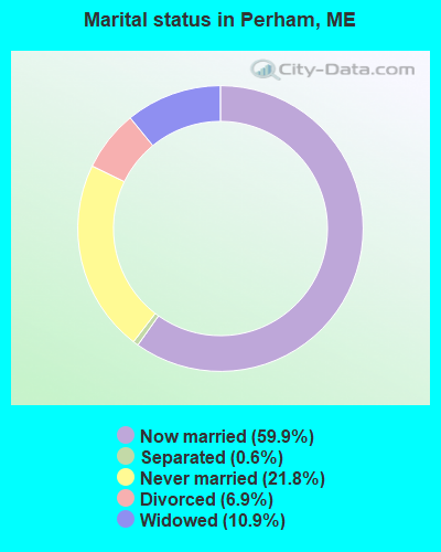
- Never married: 21.8%
- Now married: 59.9%
- Separated: 0.6%
- Widowed: 10.9%
- Divorced: 6.9%
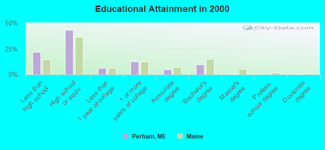
For population 25 years and over in Perham:
- High school or higher: 78.1%
- Bachelor's degree or higher: 11.3%
- Graduate or professional degree: 1.3%
- Unemployed: 6.9%
- Mean travel time to work (commute): 27.8 minutes
| Here: | 11.0 |
| Maine average: | 11.2 |


Graphs represent county-level data. Detailed 2008 Election Results
Religion statistics for Perham, ME (based on Aroostook County data)


| Religion | Adherents | Congregations |
|---|---|---|
| Catholic | 22,200 | 27 |
| Mainline Protestant | 5,845 | 40 |
| Evangelical Protestant | 4,411 | 51 |
| Other | 957 | 7 |
| Orthodox | 10 | 1 |
| None | 38,447 | - |
Food Environment Statistics:
| Aroostook County: | 4.03 / 10,000 pop. |
| Maine: | 2.80 / 10,000 pop. |
| This county: | 0.14 / 10,000 pop. |
| Maine: | 0.14 / 10,000 pop. |
| This county: | 2.22 / 10,000 pop. |
| State: | 2.20 / 10,000 pop. |
| Aroostook County: | 7.78 / 10,000 pop. |
| Maine: | 5.75 / 10,000 pop. |
| Aroostook County: | 9.17 / 10,000 pop. |
| Maine: | 11.02 / 10,000 pop. |
| This county: | 11.7% |
| Maine: | 8.2% |
| This county: | 27.6% |
| State: | 25.0% |
Strongest AM radio stations in Perham:
- WFST (600 AM; 5 kW; CARIBOU, ME; Owner: NORTHERN BROADCAST MINISTRIES, INC.)
- WEGP (1390 AM; 5 kW; PRESQUE ISLE, ME; Owner: DECELLES/SMITH MEDIA, INC.)
- WREM (710 AM; daytime; 5 kW; MONTICELLO, ME; Owner: ALLAN H WEINER)
- WRKO (680 AM; 50 kW; BOSTON, MA; Owner: ENTERCOM BOSTON LICENSE, LLC)
- WCHP (760 AM; 35 kW; CHAMPLAIN, NY; Owner: CHAMPLAIN RADIO, INC.)
- WNNZ (640 AM; 50 kW; WESTFIELD, MA; Owner: CLEAR CHANNEL BROADCASTING LICENSES, INC.)
- WEEI (850 AM; 50 kW; BOSTON, MA; Owner: ENTERCOM BOSTON LICENSE, LLC)
- WCRN (830 AM; 50 kW; WORCESTER, MA; Owner: CARTER BROADCASTING CORPORATION)
- WBZ (1030 AM; 50 kW; BOSTON, MA; Owner: INFINITY BROADCASTING OPERATIONS, INC.)
- WGY (810 AM; 50 kW; SCHENECTADY, NY; Owner: CLEAR CHANNEL BROADCASTING LICENSES, INC.)
- WZON (620 AM; 5 kW; BANGOR, ME; Owner: THE ZONE CORPORATION)
- WALE (990 AM; 50 kW; GREENVILLE, RI; Owner: NORTH AMERICAN BROADCASTING CO., INC.)
- WICY (1490 AM; 50 kW; MALONE, NY; Owner: CARTIER COMMUNICATIONS INC.)
Strongest FM radio stations in Perham:
- WBPW (96.9 FM; PRESQUE ISLE, ME; Owner: CITADEL BROADCASTING COMPANY)
- WQHR (96.1 FM; PRESQUE ISLE, ME; Owner: CITADEL BROADCASTING COMPANY)
- WOZI (101.9 FM; PRESQUE ISLE, ME; Owner: CITADEL BROADCASTING COMPANY)
- WMEM (106.1 FM; PRESQUE ISLE, ME; Owner: MAINE PUBLIC BROADCASTING CORPORATION)
- W274AF (102.7 FM; PRESQUE ISLE, ME; Owner: BANGOR BAPTIST CHURCH)
- WCXU (97.7 FM; CARIBOU, ME; Owner: THE CANXUS BROADCASTING CORPORATION)
Medal of Honor Recipients
Medal of Honor Recipient born in Perham: Edward C. Dahlgren.
Perham fatal accident list:
May 6, 2015 09:58 PM, High Meadow Road, Lat: 46.877669, Lon: -68.270261, Vehicles: 1, Persons: 1, Fatalities: 1, Drunk persons involved: 1
Sep 4, 2005 00:40 AM, Carson Road, Lat: 46.847020, Lon: -68.190980, Vehicles: 1, Persons: 1, Fatalities: 1, Drunk persons involved: 1
Feb 4, 1992 03:20 PM, Tangleridg, Vehicles: 1, Persons: 2, Pedestrians: 1, Fatalities: 1
- National Bridge Inventory (NBI) Statistics
- 1Number of bridges
- 3ft / 0.8mTotal length
- 230Total average daily traffic
- 11Total average daily truck traffic
- 368Total future (year 2036) average daily traffic
FCC Registered Microwave Towers:
1- STATION, Perham Tower (Lat: 46.880583 Lon: -68.212528), Overall height: 60.4 m, Call Sign: WHI610,
Assigned Frequencies: 2136.40 MHz, 2142.80 MHz, Grant Date: 02/02/1993, Expiration Date: 02/02/1998, Phone: (207) 848-4200
FCC Registered Amateur Radio Licenses:
6- Call Sign: K1ASJ, Licensee ID: L00952099, Grant Date: 02/01/2017, Expiration Date: 04/22/2027, Certifier: Robert S Wilk, Registrant: Robert S Wilk, Perham, ME 04766
- Call Sign: KA1IWX, Licensee ID: L00287786, Grant Date: 07/31/2008, Expiration Date: 10/28/2018, Cancellation Date: 10/29/2020, Registrant: Henry J Nutting, 371 Nutting Rd, Perham, ME 04766
- Call Sign: KB1EBH, Licensee ID: L00251322, Grant Date: 04/21/2009, Expiration Date: 05/05/2019, Cancellation Date: 05/06/2021, Certifier: Sylvia K Garey, Registrant: Sylvia K Garey, 793 Tangle Ridge Rd, Perham, ME 04766-4008
- Call Sign: N1MQP, Licensee ID: L00592691, Grant Date: 11/13/2002, Expiration Date: 11/13/2012, Cancellation Date: 11/14/2014, Registrant: Ethel M Nutting, 371 Nutting Rd, Perham, ME 04766
- Call Sign: KB1TDS, Licensee ID: L01526384, Grant Date: 10/27/2009, Expiration Date: 10/27/2019, Cancellation Date: 10/28/2021, Certifier: Tina R Bogdanovic, Registrant: Tina R Bogdanovic, 792 Tangle Ridge Rd, Perham, ME 04766
- Call Sign: KC1TJY, Licensee ID: L02701477, Grant Date: 09/01/2023, Expiration Date: 09/01/2033, Certifier: Robert J Green, Registrant: Robert J Green, 1963 Woodland Center Rd, Perham, ME 04766
FAA Registered Aircraft:
2- Aircraft: DOW ERROL K SKY-DOO LS (Category: Land, Weight: Up to 12,499 Pounds), Engine: AMA/EXPR UNKNOWN ENG (Reciprocating)
N-Number: 239ED, N239ED, N-239ED, Serial Number: 001, Year manufactured: 2007, Airworthiness Date: 08/14/2007, Certificate Issue Date: 04/30/2007
Registrant (Individual): Errol K Dow, 147 Blackstone Rd, Perham, ME 04766 - Aircraft: HELDEBERG DESIGNS LLC BLUE HERON MARATHON (Category: Land, Seats: 2, Weight: Up to 12,499 Pounds), Engine: ROTAX 582SER (65 HP) (2 Cycle)
N-Number: 4383Y, N4383Y, N-4383Y, Serial Number: HD00038M, Year manufactured: 2000, Airworthiness Date: 11/21/2006, Certificate Issue Date: 11/03/2006
Registrant (Individual): Robin R Paradis, Po Box 62, Perham, ME 04766
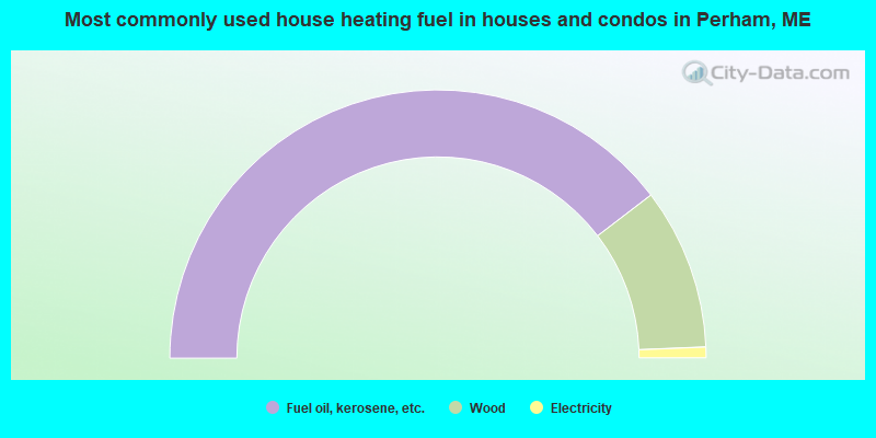
- 79.2%Fuel oil, kerosene, etc.
- 19.5%Wood
- 1.3%Electricity
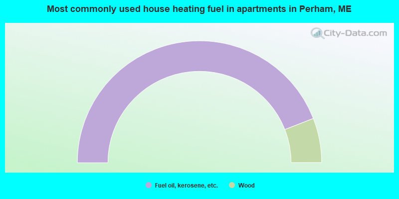
- 88.2%Fuel oil, kerosene, etc.
- 11.8%Wood
Perham compared to Maine state average:
- Median household income below state average.
- Median house value below state average.
- Unemployed percentage below state average.
- Black race population percentage significantly below state average.
- Hispanic race population percentage significantly below state average.
- Renting percentage significantly below state average.
- Length of stay since moving in significantly above state average.
- Number of rooms per house significantly below state average.
- House age significantly below state average.
- Number of college students below state average.
- Percentage of population with a bachelor's degree or higher significantly below state average.

|
Total of 1 patent application in 2008-2024.