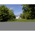
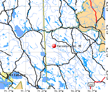
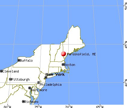
Parsonsfield, Maine
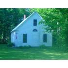
Parsonsfield: Old Blazo School RT160/Chase Rd

Parsonsfield: Sunset on West Pond 6/23/07
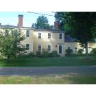
Parsonsfield: Old Blazo Farm House RT160/Chase Rd

Parsonsfield: Sunset on West Pond 6/22/07
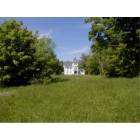
Parsonsfield: Old Blazo House RT160/Chase Rd
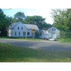
Parsonsfield: Old Parsonsfield Semanary School RT160/Chase Rd

Parsonsfield: Sunset on West Pond 6/22/07
Parsonsfield
- add
your
Submit your own pictures of this town and show them to the world
- OSM Map
- General Map
- Google Map
- MSN Map
Population change since 2000: +19.8%
 |
| Males: 954 | |
| Females: 944 |
| Median resident age: | 42.4 years |
| Maine median age: | 43.0 years |
Zip codes: 04047.
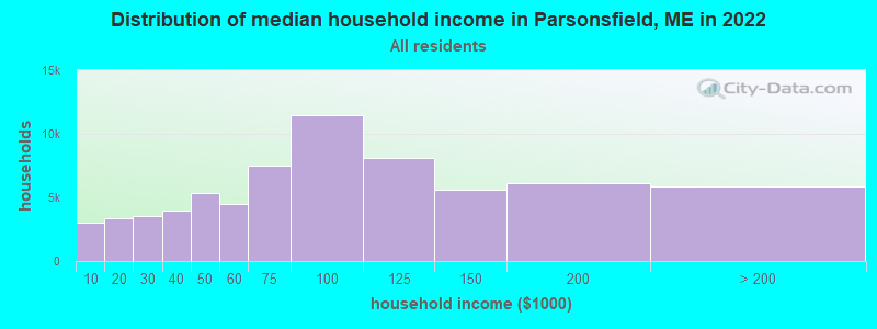
| Parsonsfield: | $60,491 |
| ME: | $69,543 |
Estimated per capita income in 2022: $34,520 (it was $16,968 in 2000)
Parsonsfield town income, earnings, and wages data
Estimated median house or condo value in 2022: $288,750 (it was $90,400 in 2000)
| Parsonsfield: | $288,750 |
| ME: | $290,600 |
Mean prices in 2022: all housing units: $451,552; detached houses: $470,451; townhouses or other attached units: $577,335; in 2-unit structures: $383,179; in 3-to-4-unit structures: $310,696; in 5-or-more-unit structures: $252,113; mobile homes: $105,501
Detailed information about poverty and poor residents in Parsonsfield, ME


- 1,83196.5%White alone
- 291.5%Two or more races
- 201.1%Hispanic
- 70.4%Asian alone
- 60.3%American Indian alone
- 30.2%Black alone
- 20.1%Other race alone
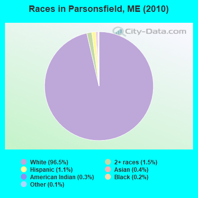
Races in Parsonsfield detailed stats: ancestries, foreign born residents, place of birth
According to our research of Maine and other state lists, there were 5 registered sex offenders living in Parsonsfield, Maine as of May 08, 2024.
The ratio of all residents to sex offenders in Parsonsfield is 380 to 1.
 Recent articles from our blog. Our writers, many of them Ph.D. graduates or candidates, create easy-to-read articles on a wide variety of topics.

 | Move to Maine??? every passing day you will find this to be true: (245 replies) |
| safest town in york county (5 replies) |
| West Falmouth?? (3 replies) |
| Moving to Andover Maine (10 replies) |
| Help us plan a scouting trip to northern Maine please (14 replies) |
| Need mouse proof metal cabinets (37 replies) |
Latest news from Parsonsfield, ME collected exclusively by city-data.com from local newspapers, TV, and radio stations
Ancestries: English (25.1%), French (14.2%), Irish (12.9%), United States (10.7%), German (6.2%), Scottish (5.1%).
Current Local Time: EST time zone
Elevation: 714 feet
Land area: 59.0 square miles.
Population density: 32 people per square mile (very low).
13 residents are foreign born
| This town: | 0.8% |
| Maine: | 2.9% |
| Parsonsfield town: | 1.2% ($1,065) |
| Maine: | 1.5% ($1,417) |
Nearest city with pop. 50,000+: Portland, ME  (31.8 miles , pop. 64,249).
Nearest city with pop. 200,000+: Boston, MA (99.3 miles , pop. 589,141).
Nearest city with pop. 1,000,000+: Bronx, NY (252.0 miles , pop. 1,332,650).
Nearest cities:
), ), ), )Latitude: 43.75 N, Longitude: 70.89 W
Area code commonly used in this area: 207

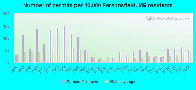
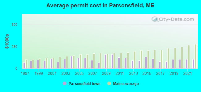
Single-family new house construction building permits:
- 2022: 8 buildings, average cost: $105,100
- 2021: 10 buildings, average cost: $105,100
- 2020: 9 buildings, average cost: $105,100
- 2019: 9 buildings, average cost: $105,100
- 2018: 4 buildings, average cost: $79,100
- 2017: 4 buildings, average cost: $79,100
- 2016: 7 buildings, average cost: $114,300
- 2015: 8 buildings, average cost: $134,800
- 2014: 7 buildings, average cost: $90,000
- 2013: 5 buildings, average cost: $90,000
- 2012: 7 buildings, average cost: $120,000
- 2011: 3 buildings, average cost: $126,700
- 2010: 1 building, cost: $160,000
- 2009: 2 buildings, average cost: $160,000
- 2008: 4 buildings, average cost: $65,000
- 2007: 8 buildings, average cost: $94,300
- 2006: 17 buildings, average cost: $118,400
- 2005: 19 buildings, average cost: $118,400
- 2004: 24 buildings, average cost: $141,600
- 2003: 23 buildings, average cost: $110,200
- 2002: 21 buildings, average cost: $72,600
- 2001: 12 buildings, average cost: $110,800
- 2000: 22 buildings, average cost: $87,500
- 1999: 9 buildings, average cost: $98,800
- 1998: 18 buildings, average cost: $89,000
- 1997: 5 buildings, average cost: $69,200
| Here: | 2.8% |
| Maine: | 3.4% |
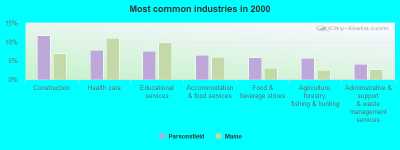
- Construction (11.7%)
- Health care (7.8%)
- Educational services (7.6%)
- Accommodation & food services (6.5%)
- Food & beverage stores (5.9%)
- Agriculture, forestry, fishing & hunting (5.7%)
- Administrative & support & waste management services (4.1%)
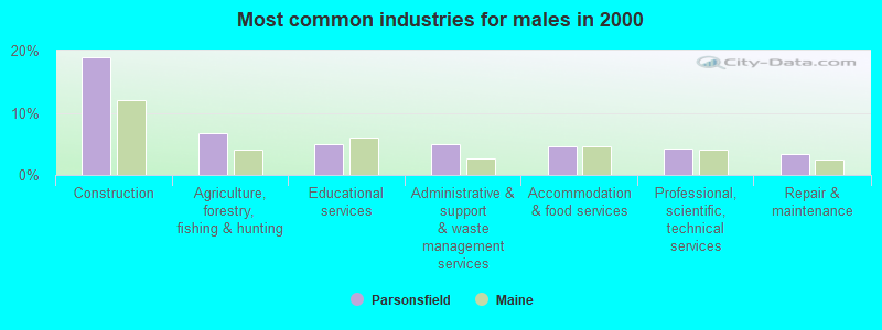
- Construction (18.9%)
- Agriculture, forestry, fishing & hunting (6.7%)
- Educational services (5.0%)
- Administrative & support & waste management services (5.0%)
- Accommodation & food services (4.5%)
- Professional, scientific, technical services (4.3%)
- Repair & maintenance (3.3%)
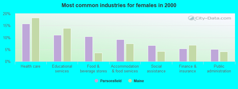
- Health care (15.8%)
- Educational services (11.1%)
- Food & beverage stores (10.4%)
- Accommodation & food services (9.2%)
- Social assistance (6.6%)
- Finance & insurance (5.4%)
- Public administration (5.1%)

- Driver/sales workers and truck drivers (5.0%)
- Preschool, kindergarten, elementary, and middle school teachers (4.9%)
- Other management occupations, except farmers and farm managers (4.1%)
- Cooks and food preparation workers (3.5%)
- Cashiers (3.4%)
- Fishing, hunting, and forestry occupations (3.1%)
- Other office and administrative support workers, including supervisors (3.0%)
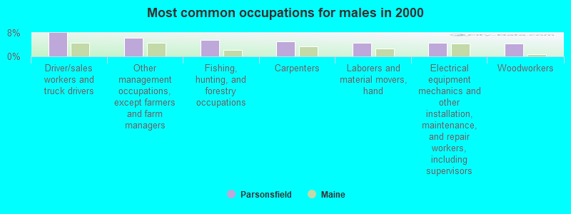
- Driver/sales workers and truck drivers (7.9%)
- Other management occupations, except farmers and farm managers (6.2%)
- Fishing, hunting, and forestry occupations (5.5%)
- Carpenters (5.0%)
- Laborers and material movers, hand (4.5%)
- Electrical equipment mechanics and other installation, maintenance, and repair workers, including supervisors (4.5%)
- Woodworkers (4.3%)

- Preschool, kindergarten, elementary, and middle school teachers (8.5%)
- Cashiers (7.3%)
- Cooks and food preparation workers (6.6%)
- Secretaries and administrative assistants (5.7%)
- Other office and administrative support workers, including supervisors (5.4%)
- Nursing, psychiatric, and home health aides (5.1%)
- Bookkeeping, accounting, and auditing clerks (4.7%)
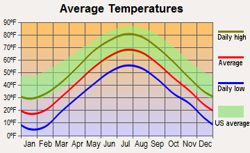
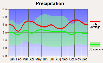
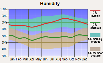
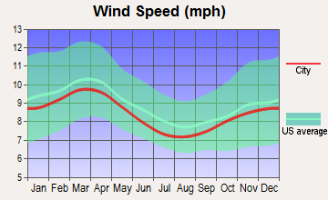
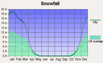
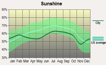
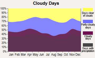
Average climate in Parsonsfield, Maine
Based on data reported by over 4,000 weather stations
(lower is better)
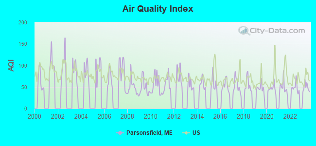
Air Quality Index (AQI) level in 2023 was 48.8. This is significantly better than average.
| City: | 48.8 |
| U.S.: | 72.6 |
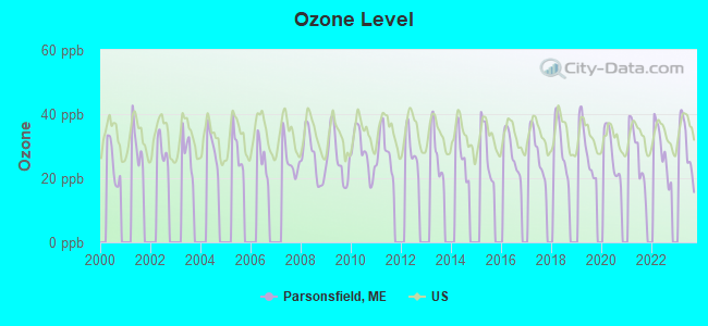
Ozone [ppb] level in 2023 was 29.7. This is about average. Closest monitor was 11.1 miles away from the city center.
| City: | 29.7 |
| U.S.: | 33.3 |
Tornado activity:
Parsonsfield-area historical tornado activity is significantly above Maine state average. It is 71% smaller than the overall U.S. average.
On 7/18/1963, a category F2 (max. wind speeds 113-157 mph) tornado 18.5 miles away from the Parsonsfield town center caused between $5000 and $50,000 in damages.
On 10/10/1966, a category F2 tornado 22.8 miles away from the town center caused between $5000 and $50,000 in damages.
Earthquake activity:
Parsonsfield-area historical earthquake activity is significantly above Maine state average. It is 73% smaller than the overall U.S. average.On 10/16/2012 at 23:12:25, a magnitude 4.7 (4.7 ML, Depth: 10.0 mi, Class: Light, Intensity: IV - V) earthquake occurred 15.9 miles away from Parsonsfield center
On 4/20/2002 at 10:50:47, a magnitude 5.3 (5.3 ML, Depth: 3.0 mi, Class: Moderate, Intensity: VI - VII) earthquake occurred 148.8 miles away from Parsonsfield center
On 1/19/1982 at 00:14:42, a magnitude 4.7 (4.5 MB, 4.7 MD, 4.5 LG) earthquake occurred 39.3 miles away from the city center
On 4/20/2002 at 10:50:47, a magnitude 5.2 (5.2 MB, 4.2 MS, 5.2 MW, 5.0 MW) earthquake occurred 149.2 miles away from the city center
On 10/7/1983 at 10:18:46, a magnitude 5.3 (5.1 MB, 5.3 LG, 5.1 ML) earthquake occurred 172.5 miles away from Parsonsfield center
On 8/21/1996 at 07:54:14, a magnitude 3.8 (3.8 LG, 3.6 LG, Depth: 6.2 mi, Class: Light, Intensity: II - III) earthquake occurred 37.7 miles away from the city center
Magnitude types: regional Lg-wave magnitude (LG), body-wave magnitude (MB), duration magnitude (MD), local magnitude (ML), surface-wave magnitude (MS), moment magnitude (MW)
Natural disasters:
The number of natural disasters in York County (31) is a lot greater than the US average (15).Major Disasters (Presidential) Declared: 23
Emergencies Declared: 8
Causes of natural disasters: Floods: 21, Storms: 16, Winter Storms: 6, Snows: 5, Winds: 3, Heavy Rains: 2, Hurricanes: 2, Blizzard: 1, Ice Storm: 1, Mudslide: 1, Snowfall: 1, Snowstorm: 1, Tornado: 1, Tropical Storm: 1 (Note: some incidents may be assigned to more than one category).
Colleges/universities with over 2000 students nearest to Parsonsfield:
- Saint Joseph's College of Maine (about 22 miles; Standish, ME; Full-time enrollment: 2,010)
- University of Southern Maine (about 32 miles; Portland, ME; FT enrollment: 6,647)
- University of New England (about 33 miles; Biddeford, ME; FT enrollment: 4,539)
- Southern Maine Community College (about 35 miles; South Portland, ME; FT enrollment: 4,666)
- Plymouth State University (about 40 miles; Plymouth, NH; FT enrollment: 4,838)
- University of New Hampshire-Main Campus (about 43 miles; Durham, NH; FT enrollment: 15,243)
- NHTI-Concord's Community College (about 49 miles; Concord, NH; FT enrollment: 2,865)
Points of interest:
Notable location: Province Lake Country Club (A). Display/hide its location on the map
Church in Parsonsfield: South Parsonsfield Free Baptist Church (A). Display/hide its location on the map
Cemeteries: Merrill Cemetery (1), Edgecomb Cemetery (2), Eastman Cemetery (3), Kezar Cemetery (4), Leavitt Cemetery (5), Trueworthy Cemetery (6), Churchill Cemetery (7). Display/hide their locations on the map
Lakes and reservoirs: Allen Pond (A), West Pond (B), Champion Pond (C), Long Pond (D), Noahs Pond (E), Spruce Pond (F), Ossipee River Reservoir (G). Display/hide their locations on the map
Streams, rivers, and creeks: South River (A), Wedgwood Brook (B), Fenderson Brook (C), Emerson Brook (D), Great Brook (E), Benson Brook (F). Display/hide their locations on the map
Birthplace of: Charles Augustus Hilton - Union Army soldier, Contessa Brewer - Newsperson, James W. Bradbury - Politician.
| This town: | 2.5 people |
| Maine: | 2.3 people |
| This town: | 67.3% |
| Whole state: | 62.9% |
| This town: | 12.0% |
| Whole state: | 9.4% |
Likely homosexual households (counted as self-reported same-sex unmarried-partner households)
- Lesbian couples: 1.2% of all households
- Gay men: 0.7% of all households
| This town: | 12.1% |
| Whole state: | 10.9% |
| This town: | 5.7% |
| Whole state: | 4.1% |
6 people in homes for the mentally retarded in 2000
Banks with branches in Parsonsfield (2011 data):
- People's United Bank: Kezar Falls Branch at 129 Federal Road, branch established on 1976/05/26. Info updated 2012/02/16: Bank assets: $27,319.3 mil, Deposits: $20,835.4 mil, headquarters in Bridgeport, CT, positive income, Commercial Lending Specialization, 374 total offices
For population 15 years and over in Parsonsfield:
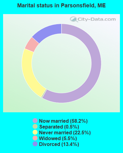
- Never married: 22.5%
- Now married: 58.2%
- Separated: 0.5%
- Widowed: 5.5%
- Divorced: 13.4%
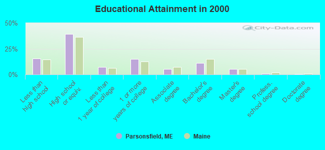
For population 25 years and over in Parsonsfield:
- High school or higher: 84.7%
- Bachelor's degree or higher: 17.8%
- Graduate or professional degree: 6.5%
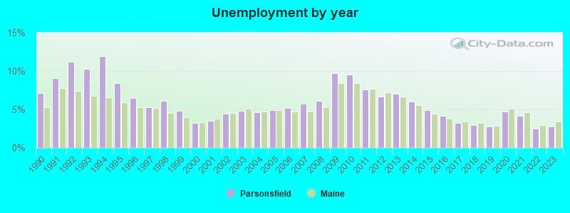
- Unemployed: 3.2%
- Mean travel time to work (commute): 35.4 minutes

| Here: | 10.3 |
| Maine average: | 11.2 |


Graphs represent county-level data. Detailed 2008 Election Results
Religion statistics for Parsonsfield, ME (based on York County data)
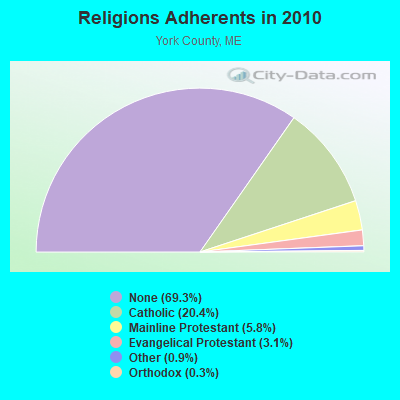

| Religion | Adherents | Congregations |
|---|---|---|
| Catholic | 40,283 | 16 |
| Mainline Protestant | 11,480 | 64 |
| Evangelical Protestant | 6,086 | 51 |
| Other | 1,847 | 18 |
| Orthodox | 625 | 3 |
| Black Protestant | 119 | 1 |
| None | 136,691 | - |
Food Environment Statistics:
| This county: | 2.24 / 10,000 pop. |
| State: | 2.80 / 10,000 pop. |
| York County: | 0.05 / 10,000 pop. |
| Maine: | 0.14 / 10,000 pop. |
| York County: | 2.09 / 10,000 pop. |
| Maine: | 2.20 / 10,000 pop. |
| York County: | 4.23 / 10,000 pop. |
| Maine: | 5.75 / 10,000 pop. |
| York County: | 12.53 / 10,000 pop. |
| State: | 11.02 / 10,000 pop. |
| York County: | 7.7% |
| Maine: | 8.2% |
| York County: | 24.0% |
| State: | 25.0% |
Strongest AM radio stations in Parsonsfield:
- WMTW (870 AM; 10 kW; GORHAM, ME; Owner: RADIO PARTNERS OF MAINE, L.P.)
- WGIN (930 AM; 10 kW; ROCHESTER, NH; Owner: CAPSTAR TX LIMITED PARTNERSHIP)
- WGAN (560 AM; 5 kW; PORTLAND, ME; Owner: SAGA COMMUNICATIONS OF NEW ENGLAND, LLC)
- WASR (1420 AM; 5 kW; WOLFEBORO, NH; Owner: RADIO WOLFEBORO, INC.)
- WRKO (680 AM; 50 kW; BOSTON, MA; Owner: ENTERCOM BOSTON LICENSE, LLC)
- WZAN (970 AM; 5 kW; PORTLAND, ME; Owner: SAGA COMMUNICATIONS OF NEW ENGLAND, LLC)
- WEEI (850 AM; 50 kW; BOSTON, MA; Owner: ENTERCOM BOSTON LICENSE, LLC)
- WJAE (1440 AM; 5 kW; WESTBROOK, ME; Owner: ALTANTIC COAST RADIO, LLC)
- WLOB (1310 AM; 5 kW; PORTLAND, ME; Owner: ATLANTIC COAST RADIO, LLC)
- WBZ (1030 AM; 50 kW; BOSTON, MA; Owner: INFINITY BROADCASTING OPERATIONS, INC.)
- WCRN (830 AM; 50 kW; WORCESTER, MA; Owner: CARTER BROADCASTING CORPORATION)
- WTME (780 AM; 10 kW; RUMFORD, ME; Owner: MOUNTAIN VALLEY BROADCASTING, INC.)
- WKOX (1200 AM; 50 kW; FRAMINGHAM, MA; Owner: CAPSTAR TX LIMITED PARTNERSHIP)
Strongest FM radio stations in Parsonsfield:
- WMEA (90.1 FM; PORTLAND, ME; Owner: MAINE PUBLIC BROADCASTING CORPORATION)
- WSCY (106.9 FM; MOULTONBOROUGH, NH; Owner: NORTHEAST COMMUNICATIONS CORPORATION)
- WPKQ (103.7 FM; NORTH CONWAY, NH; Owner: CITADEL BROADCASTING COMPANY)
- WHOM (94.9 FM; MT. WASHINGTON, NH; Owner: CITADEL BROADCASTING COMPANY)
- WBLM (102.9 FM; PORTLAND, ME; Owner: CITADEL BROADCASTING COMPANY)
- WVFM (105.7 FM; CAMPTON, NH; Owner: DEVON BROADCASTING COMPANY, INC.)
- WLKZ (104.9 FM; WOLFEBORO, NH; Owner: TELE-MEDIA COMPANY OF NEW HAMPSHIRE, L.L.C.)
- WJBQ (97.9 FM; PORTLAND, ME; Owner: CITADEL BROADCASTING COMPANY)
- WVMJ (104.5 FM; CONWAY, NH; Owner: MT. WASHINGTON RADIO & GRAMOPHONE, L.L.C.)
- WPHX-FM (92.1 FM; SANFORD, ME; Owner: FNX BROADCASTING LLC)
- WSEW (88.5 FM; SANFORD, ME; Owner: WORD RADIO EDUCATIONAL FOUNDATION)
- WMEX (106.5 FM; FARMINGTON, NH; Owner: WIMMEX, LLC)
- WTHT (107.5 FM; LEWISTON, ME; Owner: RADIO PARTNERS OF MAINE, L.P.)
- WMWV (93.5 FM; CONWAY, NH; Owner: MT. WASHINGTON RADIO & GRAMOPHONE, L.L.C.)
- WPNH-FM (100.1 FM; PLYMOUTH, NH; Owner: NORTHEAST COMMUNICATIONS CORPORATION)
- WNHI (93.3 FM; BELMONT, NH; Owner: CONCORD BROADCASTING, L.L.C.)
- WPOR (101.9 FM; PORTLAND, ME; Owner: SAGA COMMUNICATIONS OF NEW ENGLAND, LLC)
- WMTW-FM (106.7 FM; NORTH WINDHAM, ME; Owner: RADIO PARTNERS OF MAINE, L.P.)
- WMEK-FM (99.9 FM; AUBURN, ME; Owner: RADIO PARTNERS OF MAINE, L.P.)
- WMSJ (89.3 FM; FREEPORT, ME; Owner: DOWNEAST CHRISTIAN COMMUNICATIONS)
TV broadcast stations around Parsonsfield:
- WMTW-TV (Channel 8; POLAND SPRING, ME; Owner: WMTW BROADCAST GROUP, LLC)
- WCSH (Channel 6; PORTLAND, ME; Owner: PACIFIC AND SOUTHERN COMPANY, INC.)
- WMEA-TV (Channel 26; BIDDEFORD, ME; Owner: MAINE PUBLIC BROADCASTING CORP.)
- WGME-TV (Channel 13; PORTLAND, ME; Owner: WGME LICENSEE, LLC)
- WPXT (Channel 51; PORTLAND, ME; Owner: HMW, INC.)
- WPME (Channel 35; LEWISTON, ME; Owner: KB PRIME MEDIA LLC)
- W32CA (Channel 32; PORTLAND, ME; Owner: NATIONAL MINORITY T.V., INC.)
- Parsonsfield, Maine
- Fatal accident count15
- Vehicles involved in fatal accidents18
- Fatal accidents involving drunk persons:12
- Fatalities17
- Persons involved in fatal accidents29
- Pedestrians involved in fatal accidents0
- Maine average
- Fatal accident count2166
- Vehicles involved in fatal accidents3040
- Fatal accidents involving drunk persons800
- Fatalities2386
- Persons involved in fatal accidents5019
- Pedestrians involved in fatal accidents166
- National Bridge Inventory (NBI) Statistics
- 4Number of bridges
- 72ft / 21.6mTotal length
- 10,330Total average daily traffic
- 515Total average daily truck traffic
- 14,588Total future (year 2036) average daily traffic
2003 - 2018 National Fire Incident Reporting System (NFIRS) incidents
- Fire incident types reported to NFIRS in Parsonsfield, ME
- 11968.0%Structure Fires
- 3218.3%Outside Fires
- 1810.3%Mobile Property/Vehicle Fires
- 63.4%Other
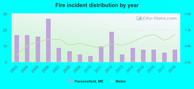 According to the data from the years 2003 - 2018 the average number of fires per year is 11. The highest number of fires - 27 took place in 2006, and the least - 4 in 2010. The data has a dropping trend.
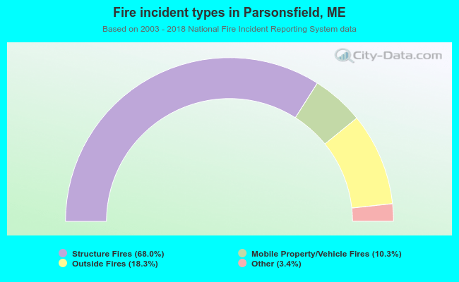 When looking into fire subcategories, the most incidents belonged to: Structure Fires (68.0%), and Outside Fires (18.3%).
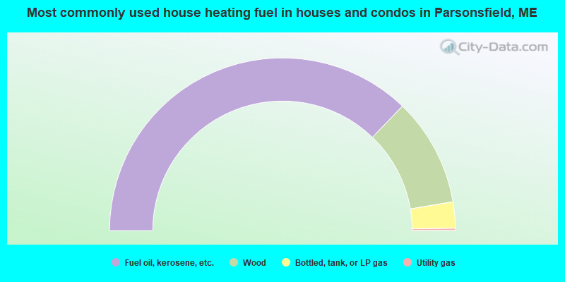
- 74.4%Fuel oil, kerosene, etc.
- 20.3%Wood
- 4.9%Bottled, tank, or LP gas
- 0.4%Utility gas
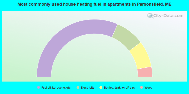
- 63.1%Fuel oil, kerosene, etc.
- 16.4%Electricity
- 14.8%Bottled, tank, or LP gas
- 5.7%Wood
Parsonsfield compared to Maine state average:
- Unemployed percentage significantly below state average.
- Black race population percentage significantly below state average.
- Foreign-born population percentage significantly below state average.
- Length of stay since moving in significantly above state average.
- Number of rooms per house significantly below state average.
- House age significantly below state average.
- Number of college students below state average.
- Percentage of population with a bachelor's degree or higher below state average.
Parsonsfield on our top lists:
- #81 on the list of "Top 101 cities with the largest percentage of people in unknown juvenile institutions (population 1,000+)"
- #21 on the list of "Top 101 counties with the highest percentage of residents that smoked 100+ cigarettes in their lives"
- #35 on the list of "Top 101 counties with the lowest number of births per 1000 residents 2007-2013"
- #70 on the list of "Top 101 counties with the highest percentage of residents that keep firearms around their homes"
- #77 on the list of "Top 101 counties with the best general health status score of residents (1-5), 3 years of data"

|
Total of 3 patent applications in 2008-2024.