Otisfield, Maine
Submit your own pictures of this town and show them to the world
- OSM Map
- Google Map
- MSN Map
Population change since 2000: +13.5%
 |
| Males: 909 | |
| Females: 861 |
| Median resident age: | 44.8 years |
| Maine median age: | 43.0 years |
Zip codes: 04270.
| Otisfield: | $87,836 |
| ME: | $69,543 |
Estimated per capita income in 2022: $44,016 (it was $19,142 in 2000)
Otisfield town income, earnings, and wages data
Estimated median house or condo value in 2022: $328,829 (it was $96,500 in 2000)
| Otisfield: | $328,829 |
| ME: | $290,600 |
Mean prices in 2022: all housing units: $514,200; detached houses: $533,395; townhouses or other attached units: $572,947; in 2-unit structures: $538,406; in 3-to-4-unit structures: $462,507; in 5-or-more-unit structures: $450,834; mobile homes: $93,551
Detailed information about poverty and poor residents in Otisfield, ME


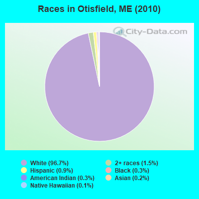
- 1,71196.7%White alone
- 271.5%Two or more races
- 160.9%Hispanic
- 50.3%Black alone
- 50.3%American Indian alone
- 40.2%Asian alone
- 20.1%Native Hawaiian and Other
Pacific Islander alone
Races in Otisfield detailed stats: ancestries, foreign born residents, place of birth
According to our research of Maine and other state lists, there were 3 registered sex offenders living in Otisfield, Maine as of May 08, 2024.
The ratio of all residents to sex offenders in Otisfield is 590 to 1.
The ratio of registered sex offenders to all residents in this city is near the state average.
 Recent articles from our blog. Our writers, many of them Ph.D. graduates or candidates, create easy-to-read articles on a wide variety of topics.
Ancestries: English (26.1%), Irish (14.8%), United States (10.4%), French (10.1%), German (8.7%), Italian (6.1%).
Current Local Time: EST time zone
Incorporated on 02/19/1798
Land area: 40.0 square miles.
Population density: 44 people per square mile (very low).
21 residents are foreign born
| This town: | 1.3% |
| Maine: | 2.9% |
| Otisfield town: | 1.3% ($1,295) |
| Maine: | 1.5% ($1,417) |
Nearest city with pop. 50,000+: Portland, ME  (31.7 miles , pop. 64,249).
Nearest city with pop. 200,000+: Boston, MA (124.7 miles , pop. 589,141).
Nearest city with pop. 1,000,000+: Bronx, NY (280.9 miles , pop. 1,332,650).
Nearest cities:
Latitude: 44.08 N, Longitude: 70.54 W
Area code commonly used in this area: 207
| Here: | 2.6% |
| Maine: | 3.4% |
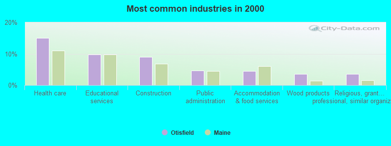
- Health care (15.1%)
- Educational services (9.7%)
- Construction (8.9%)
- Public administration (4.7%)
- Accommodation & food services (4.5%)
- Wood products (3.5%)
- Religious, grantmaking, civic, professional, similar organizations (3.5%)
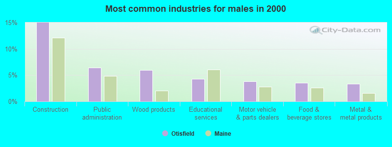
- Construction (15.0%)
- Public administration (6.4%)
- Wood products (5.9%)
- Educational services (4.3%)
- Motor vehicle & parts dealers (3.8%)
- Food & beverage stores (3.6%)
- Metal & metal products (3.3%)
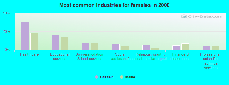
- Health care (30.8%)
- Educational services (16.4%)
- Accommodation & food services (7.0%)
- Social assistance (6.2%)
- Religious, grantmaking, civic, professional, similar organizations (5.0%)
- Finance & insurance (4.7%)
- Professional, scientific, technical services (4.4%)
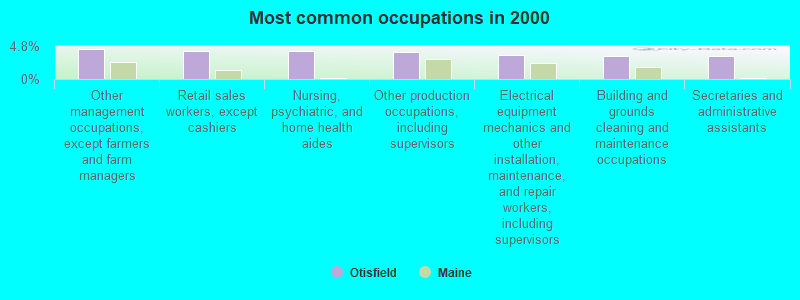
- Other management occupations, except farmers and farm managers (4.3%)
- Retail sales workers, except cashiers (4.1%)
- Nursing, psychiatric, and home health aides (4.1%)
- Other production occupations, including supervisors (3.9%)
- Electrical equipment mechanics and other installation, maintenance, and repair workers, including supervisors (3.5%)
- Building and grounds cleaning and maintenance occupations (3.4%)
- Secretaries and administrative assistants (3.4%)

- Other production occupations, including supervisors (6.7%)
- Other management occupations, except farmers and farm managers (5.9%)
- Retail sales workers, except cashiers (5.9%)
- Electrical equipment mechanics and other installation, maintenance, and repair workers, including supervisors (5.7%)
- Other sales and related occupations, including supervisors (5.0%)
- Driver/sales workers and truck drivers (4.8%)
- Vehicle and mobile equipment mechanics, installers, and repairers (4.3%)
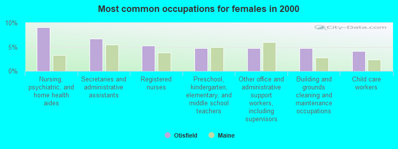
- Nursing, psychiatric, and home health aides (9.1%)
- Secretaries and administrative assistants (6.7%)
- Registered nurses (5.3%)
- Preschool, kindergarten, elementary, and middle school teachers (4.7%)
- Other office and administrative support workers, including supervisors (4.7%)
- Building and grounds cleaning and maintenance occupations (4.7%)
- Child care workers (4.1%)
Average climate in Otisfield, Maine
Based on data reported by over 4,000 weather stations


(lower is better)
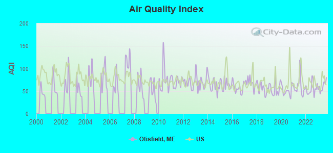
Air Quality Index (AQI) level in 2023 was 60.6. This is about average.
| City: | 60.6 |
| U.S.: | 72.6 |
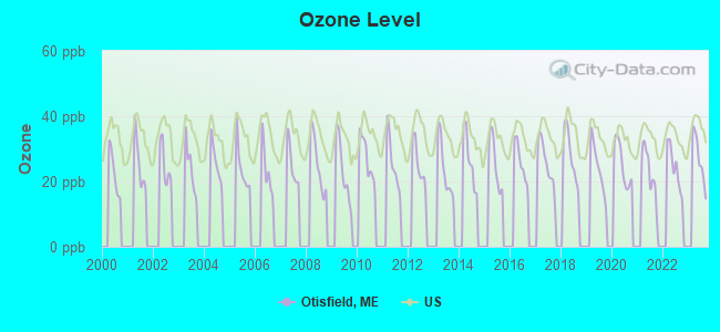
Ozone [ppb] level in 2023 was 27.1. This is better than average. Closest monitor was 8.0 miles away from the city center.
| City: | 27.1 |
| U.S.: | 33.3 |
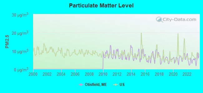
Particulate Matter (PM2.5) [µg/m3] level in 2023 was 5.52. This is significantly better than average. Closest monitor was 16.2 miles away from the city center.
| City: | 5.52 |
| U.S.: | 8.11 |
Tornado activity:
Otisfield-area historical tornado activity is above Maine state average. It is 79% smaller than the overall U.S. average.
On 7/31/1971, a category F2 (max. wind speeds 113-157 mph) tornado 27.2 miles away from the Otisfield town center caused between $50,000 and $500,000 in damages.
On 7/8/1996, a category F2 tornado 30.1 miles away from the town center caused $10,000 in damages.
Earthquake activity:
Otisfield-area historical earthquake activity is significantly above Maine state average. It is 74% smaller than the overall U.S. average.On 4/20/2002 at 10:50:47, a magnitude 5.3 (5.3 ML, Depth: 3.0 mi, Class: Moderate, Intensity: VI - VII) earthquake occurred 159.2 miles away from the city center
On 10/16/2012 at 23:12:25, a magnitude 4.7 (4.7 ML, Depth: 10.0 mi, Class: Light, Intensity: IV - V) earthquake occurred 33.8 miles away from the city center
On 4/20/2002 at 10:50:47, a magnitude 5.2 (5.2 MB, 4.2 MS, 5.2 MW, 5.0 MW) earthquake occurred 159.9 miles away from Otisfield center
On 10/7/1983 at 10:18:46, a magnitude 5.3 (5.1 MB, 5.3 LG, 5.1 ML) earthquake occurred 189.3 miles away from the city center
On 1/19/1982 at 00:14:42, a magnitude 4.7 (4.5 MB, 4.7 MD, 4.5 LG) earthquake occurred 66.4 miles away from the city center
On 8/21/1996 at 07:54:14, a magnitude 3.8 (3.8 LG, 3.6 LG, Depth: 6.2 mi, Class: Light, Intensity: II - III) earthquake occurred 41.0 miles away from Otisfield center
Magnitude types: regional Lg-wave magnitude (LG), body-wave magnitude (MB), duration magnitude (MD), local magnitude (ML), surface-wave magnitude (MS), moment magnitude (MW)
Natural disasters:
The number of natural disasters in Cumberland County (33) is a lot greater than the US average (15).Major Disasters (Presidential) Declared: 22
Emergencies Declared: 10
Causes of natural disasters: Floods: 19, Storms: 13, Snows: 7, Winter Storms: 6, Heavy Rains: 3, Hurricanes: 3, Winds: 3, Blizzard: 1, Ice Storm: 1, Mudslide: 1, Snowfall: 1, Snowstorm: 1, Tornado: 1, Other: 2 (Note: some incidents may be assigned to more than one category).
Hospitals and medical centers near Otisfield:
- BRIDGTON HEALTH CARE CENTER (Nursing Home, about 9 miles away; BRIDGTON, ME)
- NORWAY REHAB AND LIVING CENTER (Nursing Home, about 9 miles away; NORWAY, ME)
- MAINE VETERANS HOME - SO PARIS (Nursing Home, about 12 miles away; SOUTH PARIS, ME)
- ANDROSCOGGIN KIDNEY CENTER (Dialysis Facility, about 14 miles away; AUBURN, ME)
- CLOVER HOME HEALTH, INC (Home Health Center, about 15 miles away; AUBURN, ME)
- CLOVER MANOR (Nursing Home, about 15 miles away; AUBURN, ME)
- GOOD SHEPHERD HEALTH CARE - AUBURN (Nursing Home, about 15 miles away; AUBURN, ME)
Colleges/universities with over 2000 students nearest to Otisfield:
- Saint Joseph's College of Maine (about 18 miles; Standish, ME; Full-time enrollment: 2,010)
- University of Southern Maine (about 32 miles; Portland, ME; FT enrollment: 6,647)
- Southern Maine Community College (about 34 miles; South Portland, ME; FT enrollment: 4,666)
- University of Maine at Augusta (about 41 miles; Augusta, ME; FT enrollment: 3,204)
- University of New England (about 44 miles; Biddeford, ME; FT enrollment: 4,539)
- University of Maine at Farmington (about 46 miles; Farmington, ME; FT enrollment: 2,036)
- Plymouth State University (about 62 miles; Plymouth, NH; FT enrollment: 4,838)
Public elementary/middle school in Otisfield:
- OTISFIELD COMMUNITY SCHOOL (Location: 416 POWHATTAN ROAD, Grades: KG-4)
Points of interest:
Notable locations in Otisfield: Camp Powhatan (A), Otisfield Volunteer Fire Department Spurrs Corner Station (B), Otisfield Volunteer Fire Department East Otisfield Station (C), Otisfield Volunteer Fire Department Otisfield Gore Station (D). Display/hide their locations on the map
Churches in Otisfield include: Bell Hill Meeting House (A), Otisfield Community Church (B), East Otisfield Church (C). Display/hide their locations on the map
Cemeteries: Scribner Hill Upper Yard (1), Cobb Hill Road Cemetery (2), Wight Cemetery (3), South Otisfield Cemetery (4), Cedar Crest Cemetery (5), Elmwood Cemetery (6), Highland Cemetery (7). Display/hide their locations on the map
Lakes, reservoirs, and swamps: Dyer Ice Pond (A), Little Pond (B), Moose Pond (C), Pleasant Lake (D), Saturday Pond (E), Bearce Bog (F), Coon Road Swamp (G), Long Meadows (H). Display/hide their locations on the map
Streams, rivers, and creeks: Smith Brook (A), Sucker Brook (B), Jerry Brook (C), Greely Brook (D), Knights Brook (E), Eastman Brook (F), Middle Brook (G), Dolly Brook (H), Dead Hole Brook (I). Display/hide their locations on the map
Drinking water stations with addresses in Otisfield that have no violations reported:
- SEEDS OF PEACE, INC (Population served: 280, Primary Water Source Type: Groundwater)
| This town: | 2.5 people |
| Maine: | 2.3 people |
| This town: | 69.9% |
| Whole state: | 62.9% |
| This town: | 11.8% |
| Whole state: | 9.4% |
Likely homosexual households (counted as self-reported same-sex unmarried-partner households)
- Lesbian couples: 1.3% of all households
- Gay men: 0.4% of all households
| This town: | 9.1% |
| Whole state: | 10.9% |
| This town: | 2.3% |
| Whole state: | 4.1% |
8 people in religious group quarters in 2000
2 people in other group homes in 2000
For population 15 years and over in Otisfield:
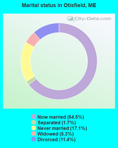
- Never married: 17.1%
- Now married: 64.5%
- Separated: 1.7%
- Widowed: 5.3%
- Divorced: 11.4%
For population 25 years and over in Otisfield:
- High school or higher: 88.0%
- Bachelor's degree or higher: 24.1%
- Graduate or professional degree: 10.0%
- Unemployed: 6.2%
- Mean travel time to work (commute): 32.9 minutes
| Here: | 10.3 |
| Maine average: | 11.2 |
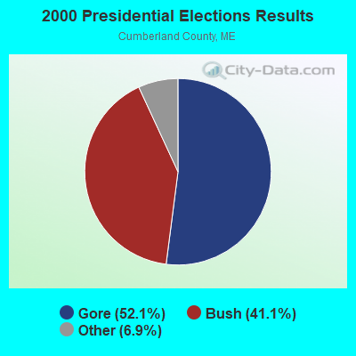
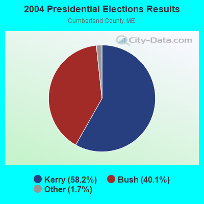
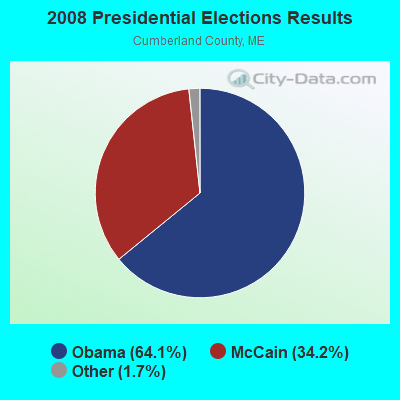
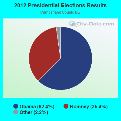
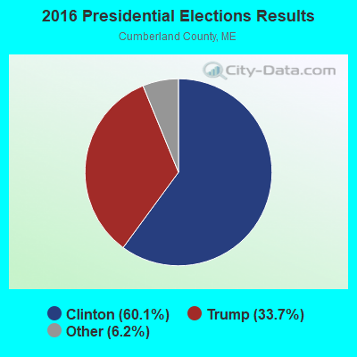
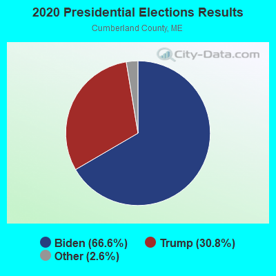
Graphs represent county-level data. Detailed 2008 Election Results
Religion statistics for Otisfield, ME (based on Cumberland County data)
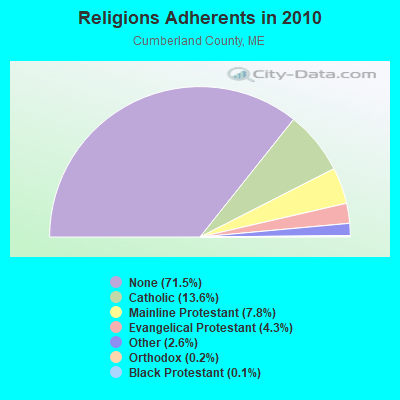
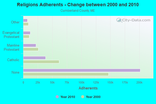
| Religion | Adherents | Congregations |
|---|---|---|
| Catholic | 38,243 | 19 |
| Mainline Protestant | 22,030 | 96 |
| Evangelical Protestant | 12,007 | 85 |
| Other | 7,187 | 44 |
| Orthodox | 500 | 1 |
| Black Protestant | 285 | 2 |
| None | 201,422 | - |
Food Environment Statistics:
| Cumberland County: | 2.62 / 10,000 pop. |
| Maine: | 2.80 / 10,000 pop. |
| Cumberland County: | 0.11 / 10,000 pop. |
| State: | 0.14 / 10,000 pop. |
| Cumberland County: | 2.44 / 10,000 pop. |
| State: | 2.20 / 10,000 pop. |
| Cumberland County: | 3.82 / 10,000 pop. |
| Maine: | 5.75 / 10,000 pop. |
| Cumberland County: | 12.01 / 10,000 pop. |
| State: | 11.02 / 10,000 pop. |
| This county: | 7.1% |
| State: | 8.2% |
| Here: | 19.5% |
| Maine: | 25.0% |
Strongest AM radio stations in Otisfield:
- WLAM (1470 AM; 5 kW; LEWISTON, ME; Owner: RADIO PARTNERS OF MAINE, L.P.)
- WTME (780 AM; 10 kW; RUMFORD, ME; Owner: MOUNTAIN VALLEY BROADCASTING, INC.)
- WMTW (870 AM; 10 kW; GORHAM, ME; Owner: RADIO PARTNERS OF MAINE, L.P.)
- WGAN (560 AM; 5 kW; PORTLAND, ME; Owner: SAGA COMMUNICATIONS OF NEW ENGLAND, LLC)
- WKTQ (1450 AM; 1 kW; SOUTH PARIS, ME; Owner: PENNESSEEWASSEE BROADCASTING CO INC.)
- WRKO (680 AM; 50 kW; BOSTON, MA; Owner: ENTERCOM BOSTON LICENSE, LLC)
- WLOB (1310 AM; 5 kW; PORTLAND, ME; Owner: ATLANTIC COAST RADIO, LLC)
- WJAE (1440 AM; 5 kW; WESTBROOK, ME; Owner: ALTANTIC COAST RADIO, LLC)
- WZAN (970 AM; 5 kW; PORTLAND, ME; Owner: SAGA COMMUNICATIONS OF NEW ENGLAND, LLC)
- WCNM (1240 AM; 1 kW; LEWISTON, ME; Owner: CHRISTIAN FAMILY RADIO, INC.)
- WEEI (850 AM; 50 kW; BOSTON, MA; Owner: ENTERCOM BOSTON LICENSE, LLC)
- WGIN (930 AM; 10 kW; ROCHESTER, NH; Owner: CAPSTAR TX LIMITED PARTNERSHIP)
- WBZ (1030 AM; 50 kW; BOSTON, MA; Owner: INFINITY BROADCASTING OPERATIONS, INC.)
Strongest FM radio stations in Otisfield:
- WBLM (102.9 FM; PORTLAND, ME; Owner: CITADEL BROADCASTING COMPANY)
- WMEA (90.1 FM; PORTLAND, ME; Owner: MAINE PUBLIC BROADCASTING CORPORATION)
- WPKQ (103.7 FM; NORTH CONWAY, NH; Owner: CITADEL BROADCASTING COMPANY)
- WHOM (94.9 FM; MT. WASHINGTON, NH; Owner: CITADEL BROADCASTING COMPANY)
- WTHT (107.5 FM; LEWISTON, ME; Owner: RADIO PARTNERS OF MAINE, L.P.)
- WOXO-FM (92.7 FM; NORWAY, ME; Owner: TRI-COUNTY BROADCASTING, INC.)
- WJBQ (97.9 FM; PORTLAND, ME; Owner: CITADEL BROADCASTING COMPANY)
- WMEK-FM (99.9 FM; AUBURN, ME; Owner: RADIO PARTNERS OF MAINE, L.P.)
- WSCY (106.9 FM; MOULTONBOROUGH, NH; Owner: NORTHEAST COMMUNICATIONS CORPORATION)
- WLOB-FM (96.3 FM; RUMFORD, ME; Owner: ATLANTIC COAST RADIO, LLC)
- WMTW-FM (106.7 FM; NORTH WINDHAM, ME; Owner: RADIO PARTNERS OF MAINE, L.P.)
- WTBM (100.7 FM; MEXICO, ME; Owner: MOUNTAIN VALLEY BROADCASTING, INC.)
- WVFM (105.7 FM; CAMPTON, NH; Owner: DEVON BROADCASTING COMPANY, INC.)
- WTOS-FM (105.1 FM; SKOWHEGAN, ME; Owner: CAPSTAR TX LIMITED PARTNERSHIP)
- WPOR (101.9 FM; PORTLAND, ME; Owner: SAGA COMMUNICATIONS OF NEW ENGLAND, LLC)
- WCYI (93.9 FM; LEWISTON, ME; Owner: CITADEL BROADCASTING COMPANY)
- WMSJ (89.3 FM; FREEPORT, ME; Owner: DOWNEAST CHRISTIAN COMMUNICATIONS)
- WCLZ (98.9 FM; BRUNSWICK, ME; Owner: CITADEL BROADCASTING COMPANY)
- WJJB-FM (95.5 FM; TOPSHAM, ME; Owner: ATLANTIC COAST RADIO, LLC)
- WBCI (105.9 FM; BATH, ME; Owner: BLOUNT COMMUNICATIONS, INC.)
TV broadcast stations around Otisfield:
- WGME-TV (Channel 13; PORTLAND, ME; Owner: WGME LICENSEE, LLC)
- WMTW-TV (Channel 8; POLAND SPRING, ME; Owner: WMTW BROADCAST GROUP, LLC)
- WCSH (Channel 6; PORTLAND, ME; Owner: PACIFIC AND SOUTHERN COMPANY, INC.)
- WPXT (Channel 51; PORTLAND, ME; Owner: HMW, INC.)
- WPME (Channel 35; LEWISTON, ME; Owner: KB PRIME MEDIA LLC)
- W32CA (Channel 32; PORTLAND, ME; Owner: NATIONAL MINORITY T.V., INC.)
- WMEA-TV (Channel 26; BIDDEFORD, ME; Owner: MAINE PUBLIC BROADCASTING CORP.)
- W03AM (Channel 3; HARRISON, ETC., ME; Owner: MAINE PUBLIC BROADCASTING CORP.)
- WPFO (Channel 23; WATERVILLE, ME; Owner: CMCG PORTLAND LICENSE LLC)
- WCBB (Channel 10; AUGUSTA, ME; Owner: MAINE PUBLIC BROADCASTING CORP.)
- National Bridge Inventory (NBI) Statistics
- 7Number of bridges
- 39ft / 11.9mTotal length
- 35,548Total average daily traffic
- 1,775Total average daily truck traffic
- 49,936Total future (year 2036) average daily traffic
FCC Registered Broadcast Land Mobile Towers:
2- Spurre Corner Fire Barn Rte 121 (Lat: 44.075361 Lon: -70.554222), Call Sign: WXB797,
Assigned Frequencies: 154.070 MHz, 154.235 MHz, 154.310 MHz, Grant Date: 10/15/2015, Expiration Date: 10/16/2025, Registrant: Federal License Management, 1784 E. 3rd Street Suite 269, Williamsport, PA 17701-3862, Phone: (570) 505-3894, Fax: (570) 651-9032, Email:
- BELL HILL ROAD, 206 Bell Hill Road (Lat: 44.090056 Lon: -70.562500), Type: Mtower, Structure height: 33.5 m, Overall height: 36.9 m, Call Sign: WPWP861,
Assigned Frequencies: 155.122 MHz, Grant Date: 12/29/2022, Expiration Date: 01/02/2033, Certifier: Garry S Dyer, Registrant: Jep Telecom Licensing Services, 3045 Mcvitty Forest Drive, Unit 102, Cave Spring, VA 24018, Phone: (941) 441-6830, Email:
FCC Registered Amateur Radio Licenses:
12 (See the full list of FCC Registered Amateur Radio Licenses in Otisfield)
- 80.0%Fuel oil, kerosene, etc.
- 12.2%Wood
- 7.1%Bottled, tank, or LP gas
- 0.7%Electricity
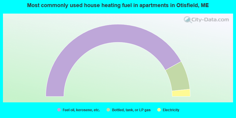
- 83.9%Fuel oil, kerosene, etc.
- 12.9%Bottled, tank, or LP gas
- 3.2%Electricity
Otisfield compared to Maine state average:
- Unemployed percentage below state average.
- Black race population percentage significantly below state average.
- Hispanic race population percentage below state average.
- Foreign-born population percentage significantly below state average.
- Renting percentage significantly below state average.
- Length of stay since moving in significantly above state average.
- Number of rooms per house significantly below state average.
- House age significantly below state average.

|
Total of 7 patent applications in 2008-2024.