Oljato, Utah
Submit your own pictures of this place and show them to the world
- OSM Map
- General Map
- Google Map
- MSN Map

| Males: 1,230 | |
| Females: 1,245 |
| Median resident age: | 21.9 years |
| Utah median age: | 27.1 years |
Zip code: 84536
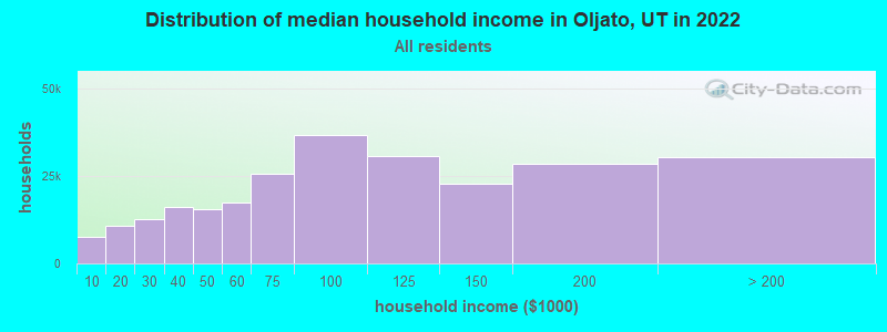
| Oljato: | $39,223 |
| UT: | $89,168 |
Estimated per capita income in 2022: $18,405 (it was $7,072 in 2000)
Oljato CCD income, earnings, and wages data
Estimated median house or condo value in 2022: $80,862 (it was $21,300 in 2000)
| Oljato: | $80,862 |
| UT: | $499,500 |
Detailed information about poverty and poor residents in Oljato, UT


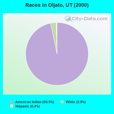
- 2,38996.5%American Indian alone
- 722.9%White alone
- 90.4%Hispanic
- 20.08%Black alone
- 20.08%Two or more races
- 10.04%Native Hawaiian and Other
Pacific Islander alone
Races in Oljato detailed stats: ancestries, foreign born residents, place of birth
 Recent articles from our blog. Our writers, many of them Ph.D. graduates or candidates, create easy-to-read articles on a wide variety of topics.
Current Local Time: MST time zone
Elevation: 4838 feet
Land area: 1143.3 square miles.
Population density: 2.2 people per square mile (very low).

| Oljato CCD: | 0.9% ($199) |
| Utah: | 0.7% ($956) |
Nearest city with pop. 50,000+: Flagstaff, AZ  (150.9 miles , pop. 52,894).
Nearest city with pop. 200,000+: Albuquerque, NM (246.2 miles , pop. 448,607).
Nearest city with pop. 1,000,000+: Phoenix, AZ (266.2 miles , pop. 1,321,045).
Nearest cities:
), ), ), Latitude: 37.09 N, Longitude: 110.28 W

| Here: | 4.4% |
| Utah: | 2.5% |
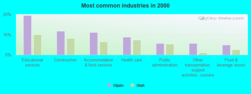
- Educational services (19.5%)
- Construction (11.8%)
- Accommodation & food services (11.2%)
- Health care (8.8%)
- Public administration (5.7%)
- Other transportation, support activities, couriers (5.7%)
- Food & beverage stores (5.0%)
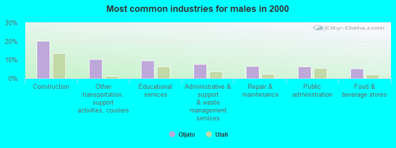
- Construction (20.2%)
- Other transportation, support activities, couriers (10.4%)
- Educational services (9.5%)
- Administrative & support & waste management services (7.6%)
- Repair & maintenance (6.7%)
- Public administration (6.4%)
- Food & beverage stores (5.2%)
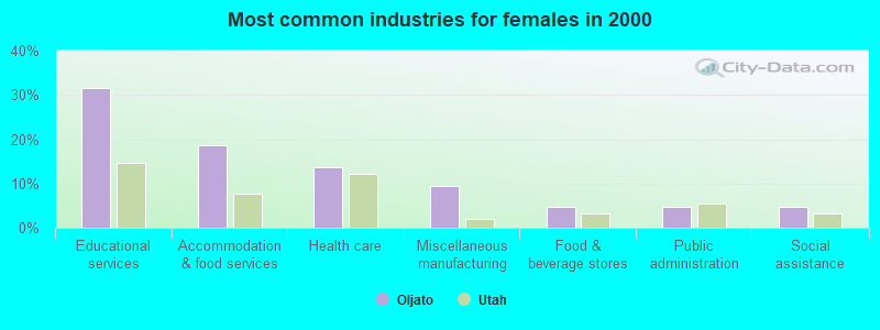
- Educational services (31.5%)
- Accommodation & food services (18.7%)
- Health care (13.6%)
- Miscellaneous manufacturing (9.5%)
- Food & beverage stores (4.8%)
- Public administration (4.8%)
- Social assistance (4.8%)
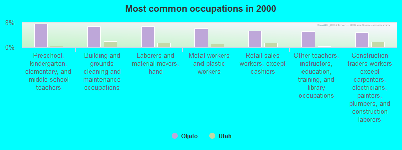
- Preschool, kindergarten, elementary, and middle school teachers (7.7%)
- Building and grounds cleaning and maintenance occupations (6.8%)
- Laborers and material movers, hand (6.8%)
- Metal workers and plastic workers (6.2%)
- Retail sales workers, except cashiers (5.3%)
- Other teachers, instructors, education, training, and library occupations (5.2%)
- Construction traders workers except carpenters, electricians, painters, plumbers, and construction laborers (4.8%)
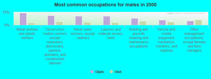
- Metal workers and plastic workers (11.3%)
- Construction traders workers except carpenters, electricians, painters, plumbers, and construction laborers (8.9%)
- Retail sales workers, except cashiers (8.3%)
- Laborers and material movers, hand (8.3%)
- Building and grounds cleaning and maintenance occupations (6.4%)
- Vehicle and mobile equipment mechanics, installers, and repairers (4.6%)
- Other management occupations, except farmers and farm managers (4.0%)
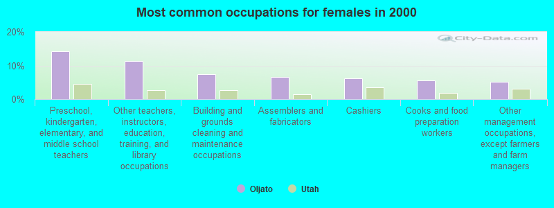
- Preschool, kindergarten, elementary, and middle school teachers (14.3%)
- Other teachers, instructors, education, training, and library occupations (11.4%)
- Building and grounds cleaning and maintenance occupations (7.3%)
- Assemblers and fabricators (6.6%)
- Cashiers (6.2%)
- Cooks and food preparation workers (5.5%)
- Other management occupations, except farmers and farm managers (5.1%)
Average climate in Oljato, Utah
Based on data reported by over 4,000 weather stations


Earthquake activity:
Oljato-area historical earthquake activity is significantly above Utah state average. It is 2069% greater than the overall U.S. average.On 6/28/1992 at 11:57:34, a magnitude 7.6 (6.2 MB, 7.6 MS, 7.3 MW, Depth: 0.7 mi, Class: Major, Intensity: VIII - XII) earthquake occurred 404.8 miles away from the city center, causing 3 deaths (1 shaking deaths, 2 other deaths) and 400 injuries, causing $100,000,000 total damage and $40,000,000 insured losses
On 10/16/1999 at 09:46:44, a magnitude 7.4 (6.3 MB, 7.4 MS, 7.2 MW, 7.3 ML) earthquake occurred 388.5 miles away from Oljato center
On 10/3/1915 at 06:52:48, a magnitude 7.6 (7.6 UK) earthquake occurred 455.2 miles away from Oljato center
On 5/19/1940 at 04:36:40, a magnitude 7.2 (7.2 UK) earthquake occurred 406.6 miles away from the city center, causing $33,000,000 total damage
On 7/21/1952 at 11:52:14, a magnitude 7.7 (7.7 UK) earthquake occurred 508.6 miles away from Oljato center, causing $50,000,000 total damage
On 8/18/1959 at 06:37:13, a magnitude 7.7 (7.7 UK) earthquake occurred 517.7 miles away from Oljato center, causing $26,000,000 total damage
Magnitude types: body-wave magnitude (MB), local magnitude (ML), surface-wave magnitude (MS), moment magnitude (MW)
Natural disasters:
The number of natural disasters in San Juan County (3) is a lot smaller than the US average (15).Emergencies Declared: 2
Causes of natural disasters: Drought: 1, Hurricane: 1, Other: 1 (Note: some incidents may be assigned to more than one category).
Colleges/universities with over 2000 students nearest to Oljato:
- San Juan College (about 119 miles; Farmington, NM; Full-time enrollment: 5,112)
- Fort Lewis College (about 134 miles; Durango, CO; FT enrollment: 3,631)
- Northern Arizona University (about 153 miles; Flagstaff, AZ; FT enrollment: 22,494)
- Coconino Community College (about 153 miles; Flagstaff, AZ; FT enrollment: 2,090)
- Southern Utah University (about 159 miles; Cedar City, UT; FT enrollment: 6,522)
- Colorado Mesa University (about 167 miles; Grand Junction, CO; FT enrollment: 7,671)
- Snow College (about 173 miles; Ephraim, UT; FT enrollment: 3,224)
Points of interest:
Notable locations in Oljato: Goulding Trading Post (A), Painted Rocks (B), Navajo Mountain Trailhead to Rainbow Bridge (C), Navajo Mountain Trailhead (D), Echo Camp (E), Oljato Trading Post (F), Rainbow Bridge Floating Marina (G), Rainbow Lodge Site Trailhead to Rainbow Bridge (H), San Juan Fire Department Monument Valley Station (I). Display/hide their locations on the map
Churches in Oljato include: The Church of Jesus Christ of Latter Day Saints (A), Hogan Church (B). Display/hide their locations on the map
Reservoirs: Nancys Pool (A), Rock Dam Reservoir (B). Display/hide their locations on the map
Streams, rivers, and creeks: Nasja Creek (A), Junction Creek (B), Cha Creek (C), West Copper Creek (D), Redbud Creek (E), Desha Creek (F), East Copper Creek (G), Oljato Wash (H), Cane Valley Wash (I). Display/hide their locations on the map
Parks in Oljato include: Monument Valley State Park (1), Rainbow Bridge National Monument (2). Display/hide their locations on the map
| This place: | 3.6 people |
| Utah: | 3.1 people |
| This place: | 78.0% |
| Whole state: | 75.2% |
| This place: | 9.5% |
| Whole state: | 4.6% |
Likely homosexual households (counted as self-reported same-sex unmarried-partner households)
- Lesbian couples: 0.3% of all households
- Gay men: 0.5% of all households
| This place: | 41.1% |
| Whole state: | 9.4% |
| This place: | 19.6% |
| Whole state: | 3.9% |
For population 15 years and over in Oljato:
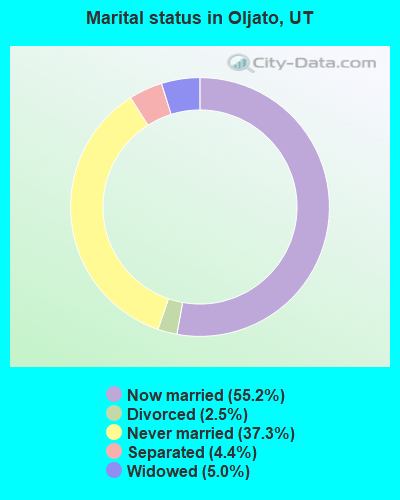
- Never married: 37.3%
- Now married: 55.2%
- Separated: 4.4%
- Widowed: 5.0%
- Divorced: 2.5%
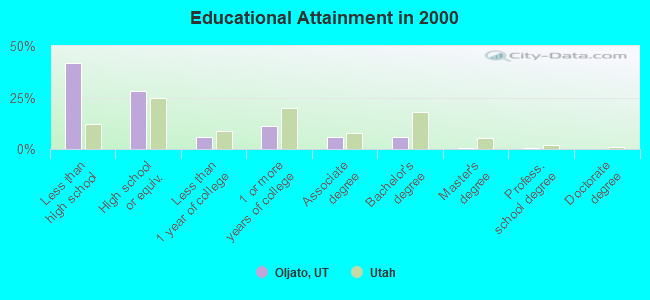
For population 25 years and over in Oljato:
- High school or higher: 58.3%
- Bachelor's degree or higher: 7.3%
- Graduate or professional degree: 1.4%
- Unemployed: 23.6%
- Mean travel time to work (commute): 34.3 minutes
| Here: | 22.3 |
| Utah average: | 10.5 |
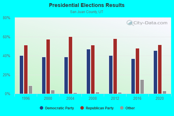
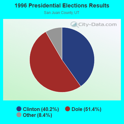
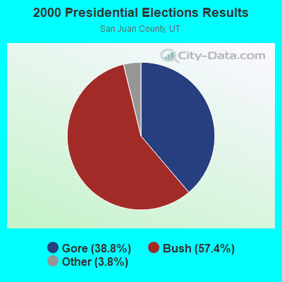
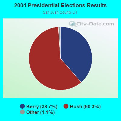
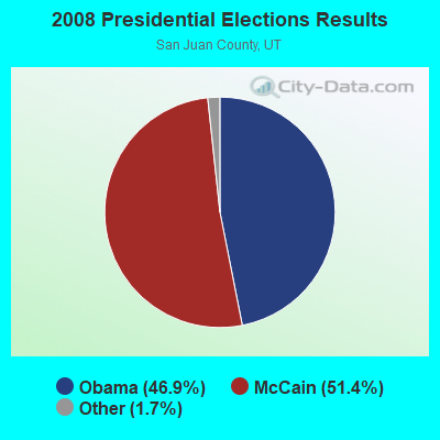
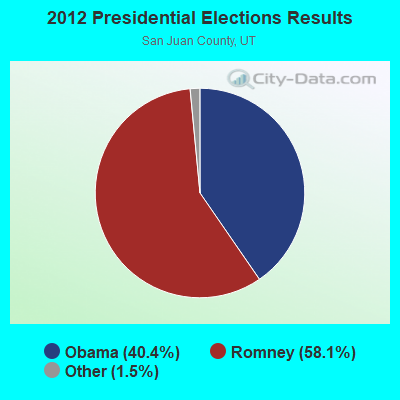

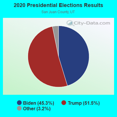
Graphs represent county-level data. Detailed 2008 Election Results
Religion statistics for Oljato, UT (based on San Juan County data)
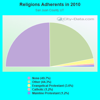
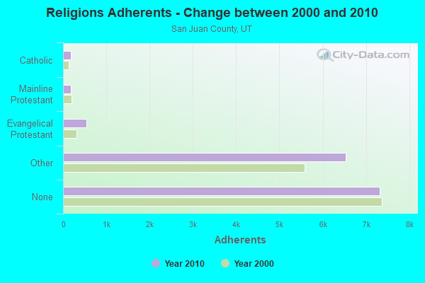
| Religion | Adherents | Congregations |
|---|---|---|
| Other | 6,533 | 22 |
| Evangelical Protestant | 535 | 9 |
| Catholic | 177 | 2 |
| Mainline Protestant | 177 | 4 |
| None | 7,324 | - |
Food Environment Statistics:
| San Juan County: | 2.08 / 10,000 pop. |
| Utah: | 1.37 / 10,000 pop. |
| San Juan County: | 0.69 / 10,000 pop. |
| Utah: | 0.41 / 10,000 pop. |
| San Juan County: | 6.23 / 10,000 pop. |
| Utah: | 2.82 / 10,000 pop. |
| San Juan County: | 6.92 / 10,000 pop. |
| Utah: | 5.09 / 10,000 pop. |
| San Juan County: | 9.4% |
| State: | 6.3% |
| San Juan County: | 25.3% |
| State: | 23.6% |
Strongest AM radio stations in Oljato:
- KTNN (660 AM; 50 kW; WINDOW ROCK, AZ; Owner: THE NAVAJO NATION)
- KHAC (880 AM; 43 kW; TSE BONITO, NM; Owner: WESTERN INDIAN MINISTRIES, INC.)
- KNZZ (1100 AM; 50 kW; GRAND JUNCTION, CO; Owner: M B C GRAND BROADCASTING, INC.)
- KMIA (710 AM; 50 kW; BLACK CANYON CITY, AZ; Owner: ENTRAVISION HOLDINGS, LLC)
- KKOB (770 AM; 50 kW; ALBUQUERQUE, NM; Owner: CITADEL BROADCASTING COMPANY)
- KDWN (720 AM; 50 kW; LAS VEGAS, NV; Owner: RADIO NEVADA CORP.)
- KALL (700 AM; 50 kW; NORTH SALT LAKE CITY, UT; Owner: CITICASTERS LICENSES, L.P.)
- KXNT (840 AM; 50 kW; NORTH LAS VEGAS, NV; Owner: INFINITY RADIO OPERATIONS INC.)
- KFNX (1100 AM; 50 kW; CAVE CREEK, AZ; Owner: NORTH AMERICAN BROADCASTING CO., INC.)
- KIQN (1010 AM; 50 kW; TOOELE, UT)
- KSL (1160 AM; 50 kW; SALT LAKE CITY, UT; Owner: BONNEVILLE HOLDING COMPANY)
- KFLT (830 AM; 50 kW; TUCSON, AZ; Owner: FAMILY LIFE B/CING SYSTEM, INC.)
- KLTT (670 AM; 50 kW; COMMERCE CITY, CO; Owner: KLZ RADIO, INC.)
Strongest FM radio stations in Oljato:
- K248AJ (97.5 FM; MONTICELLO, UT; Owner: PROCLAIMING CHRIST'S LOVE MINISTRIES)
- KFXR-FM (107.3 FM; CHINLE, AZ; Owner: CLEAR CHANNEL BROADCASTING LICENSES, INC.)
TV broadcast stations around Oljato:
- K08HQ (Channel 8; CHINLE, AZ; Owner: KOB-TV, LLC)
FCC Registered Antenna Towers:
7- Renee Chappell, Paiute Farms Rd. (Lat: 37.035722 Lon: -110.314917), Type: 76.2, Structure height: 49037 m, Overall height: 76.2 m, Registrant: Lukas, Nace, Guitierrez And Sachs, Dlafuria@fcclaw.Com, Ste. 1200, Mclea-n, Phone: (703) 584-8678
- Renee Chappell, Paiute Farms Rd. (Lat: 37.035722 Lon: -110.314917), Type: 76.2, Structure height: 49037 m, Overall height: 76.2 m, Registrant: Lukas, Nace, Guitierrez And Sachs, LLP, Dlafuria@fcclaw.Com, Ste. 1200, Mclea-n, Phone: (703) 584-8678
- Renee Chappell, Paiute Farms Rd. (Lat: 37.035722 Lon: -110.314917), Type: 76.2, Structure height: 49037 m, Overall height: 76.2 m, Registrant: Lukas, Nace, Guitierrez And Sachs, LLP, Dlafuria@fcclaw.Com, Ste. 1200, Mclea-n, Phone: (703) 584-8678
- Gwen Sherwood, Paiute Farms Rd. (Lat: 37.035722 Lon: -110.314917), Type: 76.2, Structure height: 49037 m, Overall height: 76.2 m, Registrant: Smith Bagley, Inc., Gpine@cellularoneaz.Com, , Show -Low, Phone: (928) 537-0375
- Ella McNeil, Paiute Farms Rd. (Lat: 37.035722 Lon: -110.314917), Type: 76.2, Structure height: 49037 m, Overall height: 76.2 m, Registrant: Smith Bagley Inc, Emcneil@cellularoneaz.Com, , Show -Low, Phone: (928) 537-0690
- Susan Gabler, Paiute Farms Rd. (Lat: 37.035722 Lon: -110.314917), Type: 77.7, Structure height: 49037 m, Overall height: 76.2 m, Registrant: Smith Bagley Inc, Sgabler@cellularoneaz.Com, Suite 103, Show -Low, Phone: (928) 537-0375
- Susan Gabler, Paiute Farms Rd. (Lat: 37.035722 Lon: -110.314917), Type: 77.7, Structure height: 49037 m, Overall height: 76.2 m, Registrant: Smith Bagley Inc, Sgabler@cellularoneaz.Com, Suite 103, Show -Low, Phone: (928) 537-0375
FCC Registered Broadcast Land Mobile Towers:
1- OLJATO MT., 2.1 Km Ene Of (Lat: 37.041111 Lon: -110.330333), Type: Pipe, Structure height: 6.1 m, Call Sign: WQFV590,
Assigned Frequencies: 453.600 MHz, 154.965 MHz, Grant Date: 08/25/2016, Expiration Date: 10/16/2026, Certifier: Rick M Bailey, Registrant: Wf Communications, LLC, 3991 Spanish Valley Dr., Moab, UT 84532, Phone: (435) 259-8240, Fax: (435) 259-9379, Email:
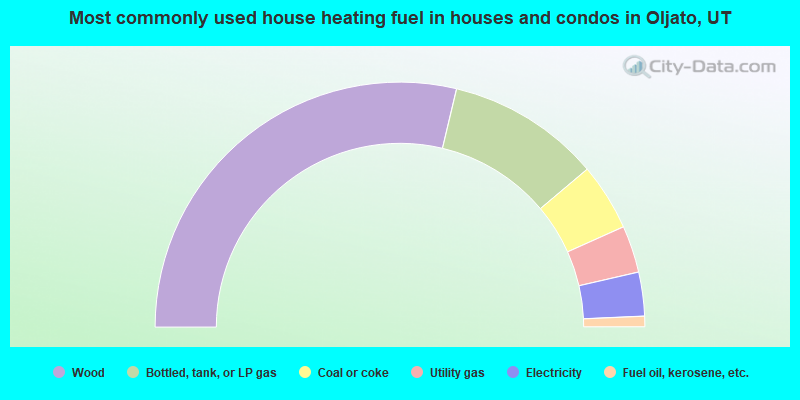
- 57.5%Wood
- 20.3%Bottled, tank, or LP gas
- 8.9%Coal or coke
- 6.2%Utility gas
- 5.8%Electricity
- 1.4%Fuel oil, kerosene, etc.
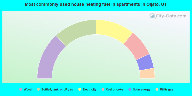
- 26.1%Wood
- 23.9%Bottled, tank, or LP gas
- 21.6%Electricity
- 14.8%Coal or coke
- 8.0%Solar energy
- 5.7%Utility gas
Oljato compared to Utah state average:
- Median household income significantly below state average.
- Median house value significantly below state average.
- Unemployed percentage above state average.
- Black race population percentage significantly below state average.
- Hispanic race population percentage significantly below state average.
- Median age significantly below state average.
- Foreign-born population percentage significantly below state average.
- Renting percentage significantly below state average.
- Length of stay since moving in significantly above state average.
- Number of rooms per house significantly below state average.
- House age significantly below state average.
- Number of college students below state average.
- Percentage of population with a bachelor's degree or higher significantly below state average.