Oakhurst-North Fork, California
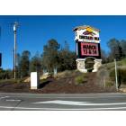
Oakhurst-North Fork: Picayune Rancheria's - Chukchansi Gold Resort & Casino, approx 10 miles south of Oakhurst on SR-41, in Coursegold
- add
your
Submit your own pictures of this place and show them to the world
- OSM Map
- Google Map
- MSN Map
| Males: 14,799 | |
| Females: 15,445 |
| Median resident age: | 45.2 years |
| California median age: | 33.3 years |
Zip code: 93614
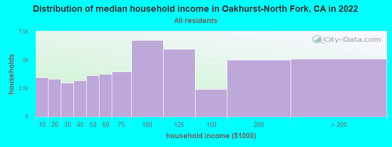
| Oakhurst-North Fork: | $83,458 |
| CA: | $91,551 |
Estimated per capita income in 2022: $42,277 (it was $20,245 in 2000)
Oakhurst-North Fork CCD income, earnings, and wages data
Estimated median house or condo value in 2022: $506,928 (it was $151,400 in 2000)
| Oakhurst-North Fork: | $506,928 |
| CA: | $715,900 |
Mean prices in 2022: all housing units: $428,338; detached houses: $442,742; townhouses or other attached units: $483,099; in 5-or-more-unit structures: $367,091; mobile homes: $216,256; occupied boats, rvs, vans, etc.: $31,674
Oakhurst-North Fork, CA residents, houses, and apartments details
Detailed information about poverty and poor residents in Oakhurst-North Fork, CA
Compare current foreclosures near your location:
| Photo | Address | Area | Beds / Baths | Price | Details |
|---|---|---|---|---|---|

|
#1
Bayberry Cir
Columbus, OH 43207
|
1,564 sq. feet
|
1 baths 3 beds |
$127,500
|
show details |

|
#2
S High St
Columbus, OH 43207
|
1,678 sq. feet
|
2 baths 4 beds |
$31,900
|
show details |

|
#3
E 21st Ave
Columbus, OH 43211
|
1,061 sq. feet
|
1 baths 3 beds |
$179,900
|
show details |

|
#4
Marshrun Dr
Grove City, OH 43123
|
2,036 sq. feet
|
2 baths 4 beds |
show details | |

|
#5
E Howard Rd
Columbus, OH 43207
|
1,056 sq. feet
|
1 baths 3 beds |
show details | |

|
#6
Hiawatha Park Dr
Columbus, OH 43211
|
1,278 sq. feet
|
1 baths 4 beds |
show details | |

|
#7
Brookstone Dr
Westerville, OH 43082
|
1,783 sq. feet
|
3 baths 3 beds |
show details | |

|
#8
N Roys Ave
Columbus, OH 43204
|
1,248 sq. feet
|
2 baths 3 beds |
show details | |

|
#9
Summertree Ln
Westerville, OH 43081
|
2,496 sq. feet
|
2 baths 3 beds |
show details | |

|
#10
Mink St SW
Pataskala, OH 43062
|
1,442 sq. feet
|
1 baths 3 beds |
show details |
| Photo | Address | Area | Beds / Baths | Price | Details |
|---|---|---|---|---|---|

|
#11
Armada Rd
Columbus, OH 43232
|
1,028 sq. feet
|
1 baths 4 beds |
show details | |

|
#12
Midland Ave
Columbus, OH 43223
|
1,518 sq. feet
|
1 baths 2 beds |
show details | |

|
#13
Grasmere Ave
Columbus, OH 43211
|
720 sq. feet
|
1 baths 2 beds |
show details | |

|
#14
High Free Pike
West Jefferson, OH 43162
|
1,216 sq. feet
|
2 baths 4 beds |
show details | |

|
#15
Wrexham Ave
Columbus, OH 43223
|
1,235 sq. feet
|
1 baths 3 beds |
show details | |

|
#16
Meadowbrook Dr
Columbus, OH 43207
|
1,752 sq. feet
|
2 baths 4 beds |
show details | |

|
#17
Chidley St
Galloway, OH 43119
|
1,502 sq. feet
|
1 baths 3 beds |
show details | |

|
#18
Kingsglen Dr
Grove City, OH 43123
|
1,635 sq. feet
|
2 baths 4 beds |
show details | |

|
#19
Fergus Rd
Grove City, OH 43123
|
3,312 sq. feet
|
2 baths 4 beds |
show details | |

|
#20
S Hague Ave
Columbus, OH 43204
|
979 sq. feet
|
1 baths 2 beds |
show details |
| Photo | Address | Area | Beds / Baths | Price | Details |
|---|---|---|---|---|---|

|
#21
E Welch Ave
Columbus, OH 43207
|
1,864 sq. feet
|
2 baths 4 beds |
show details | |

|
#22
Striebel Ct
Columbus, OH 43227
|
925 sq. feet
|
1 baths 3 beds |
show details | |

|
#23
S Richardson Ave
Columbus, OH 43204
|
1,520 sq. feet
|
2 baths 3 beds |
show details | |

|
#24
Lehner Rd
Columbus, OH 43224
|
1,628 sq. feet
|
2 baths 4 beds |
show details | |

|
#25
Derrer Rd -872
Columbus, OH 43204
|
1,667 sq. feet
|
2 baths 5 beds |
show details | |

|
#26
Fahlander Dr N
Columbus, OH 43229
|
1,338 sq. feet
|
2 baths 3 beds |
show details | |

|
#27
Sleeping Meadow Dr
New Albany, OH 43054
|
3,211 sq. feet
|
2 baths 4 beds |
show details | |

|
#28
Gladys Rd
Columbus, OH 43228
|
832 sq. feet
|
1 baths 3 beds |
show details | |

|
#29
N 18th St
Columbus, OH 43203
|
1,690 sq. feet
|
1 baths 4 beds |
show details | |

|
#30
Chester Rd
Columbus, OH 43221
|
3,300 sq. feet
|
4 baths 5 beds |
show details |
| Photo | Address | Area | Beds / Baths | Price | Details |
|---|---|---|---|---|---|

|
#31
Glenmate Ct
Columbus, OH 43223
|
1,050 sq. feet
|
1 baths 3 beds |
show details | |

|
#32
Ashgrove Dr
Grove City, OH 43123
|
1,772 sq. feet
|
2 baths 4 beds |
show details | |

|
#33
Hildreth Ave
Columbus, OH 43203
|
1,798 sq. feet
|
2 baths 4 beds |
show details | |

|
#34
Fairfield Ave
Columbus, OH 43203
|
984 sq. feet
|
1 baths 2 beds |
show details | |

|
#35
London Groveport Rd
Grove City, OH 43123
|
816 sq. feet
|
1 baths 2 beds |
show details | |

|
#36
Stoneybrook Blvd # 21a
Hilliard, OH 43026
|
1,231 sq. feet
|
2 baths 3 beds |
show details | |

|
#37
Scottwood Rd
Columbus, OH 43227
|
1,008 sq. feet
|
1 baths 3 beds |
show details | |

|
#38
Stoneybrook B 21a
Hilliard, OH 43026
|
1,031 sq. feet
|
1 baths 3 beds |
show details | |

|
#39
Casa Blvd
Grove City, OH 43123
|
1,002 sq. feet
|
1 baths 2 beds |
show details | |

|
#40
Wesson Dr
Columbus, OH 43232
|
1,200 sq. feet
|
1 baths 3 beds |
show details |
| Photo | Address | Area | Beds / Baths | Price | Details |
|---|---|---|---|---|---|

|
#41
Southbend Dr
Canal Winchester, OH 43110
|
3,394 sq. feet
|
2 baths 3 beds |
show details | |

|
#42
Nantucket Ave
Columbus, OH 43235
|
1,864 sq. feet
|
2 baths 3 beds |
show details | |

|
#43
Illinois Ave
Westerville, OH 43081
|
1,120 sq. feet
|
1 baths 3 beds |
show details | |

|
#44
Tea Party Pl
Columbus, OH 43207
|
1,176 sq. feet
|
2 baths 3 beds |
show details | |

|
#45
Ridgebury Dr
Hilliard, OH 43026
|
832 sq. feet
|
1 baths 2 beds |
show details | |

|
#46
Renford Ct
Powell, OH 43065
|
1,795 sq. feet
|
1 baths 3 beds |
show details | |

|
#47
Ratify Blvd
Columbus, OH 43207
|
1,356 sq. feet
|
2 baths 3 beds |
show details | |

|
#48
Royal Farm E
Blacklick, OH 43004
|
2,425 sq. feet
|
2 baths 3 beds |
show details | |

|
#49
Mango Ln
Hilliard, OH 43026
|
1,024 sq. feet
|
1 baths 2 beds |
show details | |

|
Check over 1 million property listings on Foreclosure.com!
|
browse all offers | |||

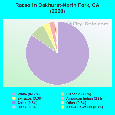
- 21,79184.7%White alone
- 1,9597.6%Hispanic
- 8393.3%Two or more races
- 7302.8%American Indian alone
- 1410.5%Asian alone
- 1380.5%Other race alone
- 740.3%Black alone
- 620.2%Native Hawaiian and Other
Pacific Islander alone
 Recent articles from our blog. Our writers, many of them Ph.D. graduates or candidates, create easy-to-read articles on a wide variety of topics.
Current Local Time: PST time zone
Land area: 1364.8 square miles.
Population density: 22 people per square mile (very low).
| Oakhurst-North Fork CCD: | 0.8% ($1,224) |
| California: | 0.8% ($1,564) |
Nearest city with pop. 50,000+: Clovis, CA  (30.1 miles , pop. 68,468).
Nearest city with pop. 200,000+: Fresno, CA (33.1 miles , pop. 427,652).
Nearest city with pop. 1,000,000+: Los Angeles, CA (231.4 miles , pop. 3,694,820).
Nearest cities:
), ), ), ), ), Latitude: 37.25 N, Longitude: 119.70 W
Area code commonly used in this area: 559
| Here: | 7.9% |
| California: | 5.1% |
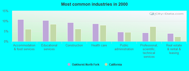
- Accommodation & food services (10.8%)
- Educational services (10.3%)
- Construction (9.3%)
- Health care (8.7%)
- Public administration (4.6%)
- Professional, scientific, technical services (4.3%)
- Real estate & rental & leasing (3.9%)
- Construction (14.9%)
- Accommodation & food services (9.1%)
- Public administration (6.3%)
- Educational services (6.1%)
- Agriculture, forestry, fishing & hunting (4.4%)
- Health care (3.9%)
- Repair & maintenance (3.7%)
- Educational services (15.6%)
- Health care (14.8%)
- Accommodation & food services (12.9%)
- Real estate & rental & leasing (5.3%)
- Professional, scientific, technical services (5.0%)
- Finance & insurance (4.3%)
- Social assistance (3.3%)

- Other management occupations, except farmers and farm managers (6.1%)
- Other sales and related occupations, including supervisors (5.5%)
- Building and grounds cleaning and maintenance occupations (4.8%)
- Preschool, kindergarten, elementary, and middle school teachers (3.2%)
- Electrical equipment mechanics and other installation, maintenance, and repair workers, including supervisors (3.1%)
- Retail sales workers, except cashiers (2.9%)
- Other office and administrative support workers, including supervisors (2.8%)
- Other management occupations, except farmers and farm managers (8.4%)
- Building and grounds cleaning and maintenance occupations (5.8%)
- Electrical equipment mechanics and other installation, maintenance, and repair workers, including supervisors (5.2%)
- Other sales and related occupations, including supervisors (5.0%)
- Vehicle and mobile equipment mechanics, installers, and repairers (3.7%)
- Construction traders workers except carpenters, electricians, painters, plumbers, and construction laborers (3.3%)
- Retail sales workers, except cashiers (3.2%)
- Other sales and related occupations, including supervisors (6.2%)
- Preschool, kindergarten, elementary, and middle school teachers (5.8%)
- Secretaries and administrative assistants (5.3%)
- Information and record clerks, except customer service representatives (4.8%)
- Other office and administrative support workers, including supervisors (4.3%)
- Bookkeeping, accounting, and auditing clerks (4.2%)
- Other teachers, instructors, education, training, and library occupations (3.7%)
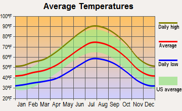
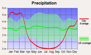
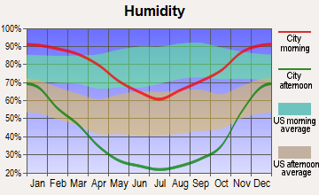
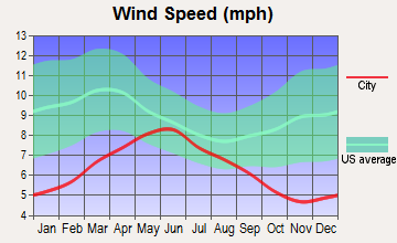
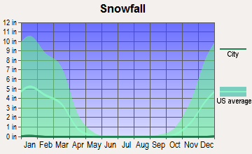
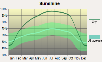
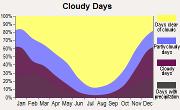
Average climate in Oakhurst-North Fork, California
Based on data reported by over 4,000 weather stations
(lower is better)
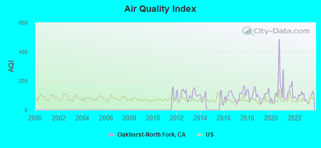
Air Quality Index (AQI) level in 2023 was 84.9. This is about average.
| City: | 84.9 |
| U.S.: | 72.6 |
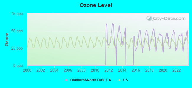
Ozone [ppb] level in 2023 was 38.9. This is about average. Closest monitor was 2.8 miles away from the city center.
| City: | 38.9 |
| U.S.: | 33.3 |
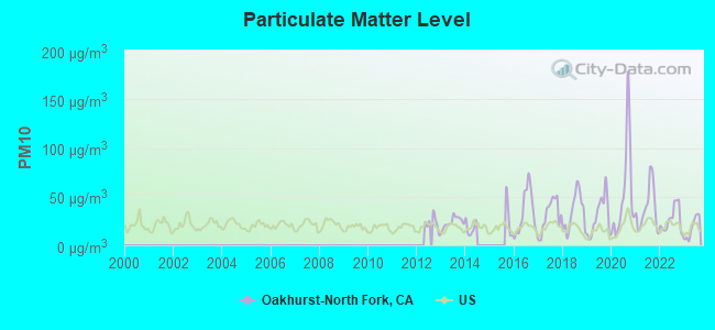
Particulate Matter (PM10) [µg/m3] level in 2023 was 18.1. This is about average. Closest monitor was 2.8 miles away from the city center.
| City: | 18.1 |
| U.S.: | 19.2 |
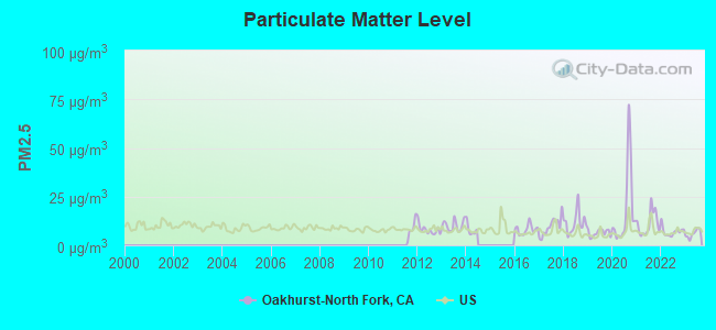
Particulate Matter (PM2.5) [µg/m3] level in 2023 was 5.91. This is better than average. Closest monitor was 2.8 miles away from the city center.
| City: | 5.91 |
| U.S.: | 8.11 |
Earthquake activity:
Oakhurst-North Fork-area historical earthquake activity is significantly above California state average. It is 8545% greater than the overall U.S. average.On 4/18/1906 at 13:12:21, a magnitude 7.9 (7.9 UK, Class: Major, Intensity: VIII - XII) earthquake occurred 188.0 miles away from the city center, causing $524,000,000 total damage
On 7/21/1952 at 11:52:14, a magnitude 7.7 (7.7 UK) earthquake occurred 160.7 miles away from the city center, causing $50,000,000 total damage
On 11/4/1927 at 13:51:53, a magnitude 7.5 (7.5 UK) earthquake occurred 178.1 miles away from the city center
On 12/21/1932 at 06:10:09, a magnitude 7.2 (7.2 UK) earthquake occurred 123.8 miles away from the city center
On 10/18/1989 at 00:04:15, a magnitude 7.1 (6.5 MB, 7.1 MS, 6.9 MW, 7.0 ML) earthquake occurred 114.6 miles away from the city center, causing 62 deaths (62 shaking deaths) and 3757 injuries, causing $1,305,032,704 total damage
On 10/3/1915 at 06:52:48, a magnitude 7.6 (7.6 UK) earthquake occurred 253.8 miles away from Oakhurst-North Fork center
Magnitude types: body-wave magnitude (MB), local magnitude (ML), surface-wave magnitude (MS), moment magnitude (MW)
Natural disasters:
The number of natural disasters in Madera County (14) is near the US average (15).Major Disasters (Presidential) Declared: 9
Emergencies Declared: 2
Causes of natural disasters: Floods: 7, Storms: 5, Landslides: 4, Winter Storms: 3, Fires: 2, Freezes: 2, Drought: 1, Hurricane: 1, Mudslide: 1, Other: 1 (Note: some incidents may be assigned to more than one category).
Colleges/universities with over 2000 students nearest to Oakhurst-North Fork:
- University of Phoenix-Central Valley Campus (about 28 miles; Fresno, CA; Full-time enrollment: 2,109)
- Institute of Technology Inc (about 29 miles; Clovis, CA; FT enrollment: 2,483)
- Heald College-Fresno (about 31 miles; Fresno, CA; FT enrollment: 2,199)
- California State University-Fresno (about 31 miles; Fresno, CA; FT enrollment: 18,993)
- Fresno City College (about 35 miles; Fresno, CA; FT enrollment: 12,994)
- Fresno Pacific University (about 37 miles; Fresno, CA; FT enrollment: 3,083)
- University of California-Merced (about 41 miles; Merced, CA; FT enrollment: 5,981)
Public high schools in Oakhurst-North Fork:
- MOUNTAIN OAKS HIGH (Students: 12, Location: 33030 RD. 228, Grades: 9-12)
- MANZANITA COMMUNITY DAY (Students: 1, Location: 32996 RD. 228, Grades: 7-12)
Public elementary/middle schools in Oakhurst-North Fork:
- NORTH FORK ELEMENTARY (Students: 212, Location: 33087 RD. 228, Grades: KG-8)
- COUGAR SPRINGS COMMUNITY DAY (Students: 3, Location: 32996 RD. 228, Grades: 4-8)
Points of interest:
Notable locations in Oakhurst-North Fork: Spring Cove Campground (A), Buchenau Cabin (B), Reds Meadow Campground (C), The Falls (D), Sweetwater Campground (E), Rocky Point Picnic Area (F), Minarets Work Center (G), Logan Meadow Campground (H), Gaggs Campground (I), Wide Awake Ranch (J), Veater Ranch (K), Urrutia Ranch (L), United States Forest Service Headquarters (M), Twentytwo Mile House (N), The Forks (O), Summit House (P), Soquel Meadow Ranch (Q), Soda Springs Campground (R), Rosedale Ranch (S), High Trail Trailhead (T). Display/hide their locations on the map
Churches in Oakhurst-North Fork include: North Fork Indian Mission (A), Christ Episcopal Church (B), Raymond Community Church (C). Display/hide their locations on the map
Cemeteries: Picayune Cemetery (1), Fine Gold Cemetery (2), North Fork Cemetery (3), Walker Cemetery (4), Raymond Cemetery (5). Display/hide their locations on the map
Lakes and reservoirs: Lost Lake (A), Summit Lake (B), Superior Lake (C), Lady Lake (D), Gale Lake (E), Harriet Lake (F), Anne Lake (G), Grouse Lake (H). Display/hide their locations on the map
Streams, rivers, and creeks: Chapman Creek (A), Black Creek (B), Indian Creek (C), Bald Mill Creek (D), Crooks Creek (E), Stevenson Creek (F), Stairway Creek (G), South Fork San Joaquin River (H), Rancheria Creek (I). Display/hide their locations on the map
Parks in Oakhurst-North Fork include: Yosemite Mountain Sugar Pine Historical Railroad (1), Wassama Round House State Historic Park (2), Devils Postpile National Monument (3), Millerton Lake State Recreation Area (4), North Fork Recreation Area Memorial Park (5), Fresno Flats Historic Park (6), Indian Lakes Park (7), Eastman Lake Recreation Area (8), Hensley Lake Recreation Area (9). Display/hide their locations on the map
| This place: | 2.4 people |
| California: | 2.9 people |
| This place: | 67.7% |
| Whole state: | 68.7% |
| This place: | 6.0% |
| Whole state: | 7.2% |
Likely homosexual households (counted as self-reported same-sex unmarried-partner households)
- Lesbian couples: 0.6% of all households
- Gay men: 0.6% of all households
| This place: | 10.2% |
| Whole state: | 14.2% |
| This place: | 4.4% |
| Whole state: | 6.3% |
9 people in group homes intended for adults in 2010
People in group quarters in Oakhurst-North Fork in 2000:
- 62 people in homes for the mentally retarded
- 59 people in nursing homes
- 33 people in other noninstitutional group quarters
- 5 people in homes for abused, dependent, and neglected children
For population 15 years and over in Oakhurst-North Fork:
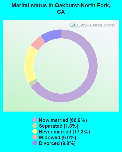
- Never married: 17.3%
- Now married: 66.9%
- Separated: 1.8%
- Widowed: 6.0%
- Divorced: 9.8%
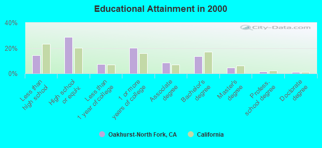
For population 25 years and over in Oakhurst-North Fork:
- High school or higher: 85.8%
- Bachelor's degree or higher: 20.8%
- Graduate or professional degree: 7.3%
- Unemployed: 5.9%
- Mean travel time to work (commute): 27.9 minutes
| Here: | 10.0 |
| California average: | 16.1 |
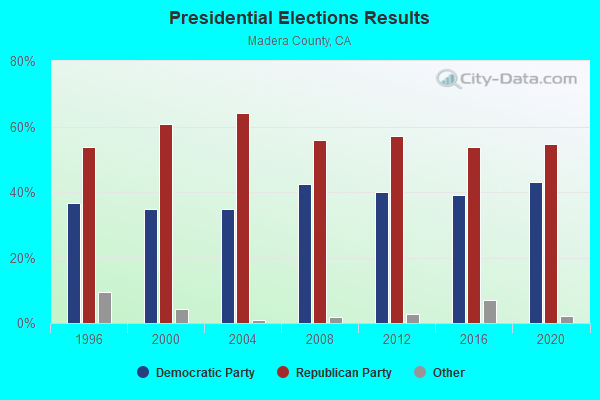
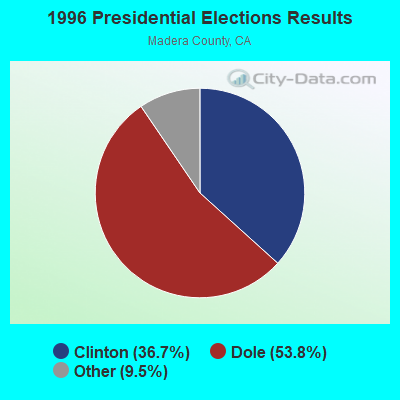
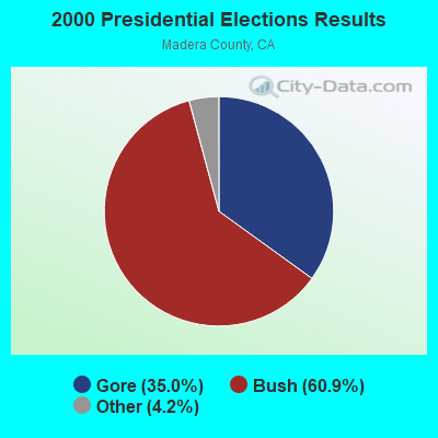
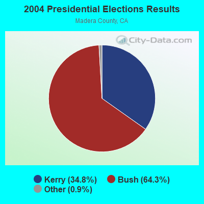
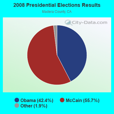
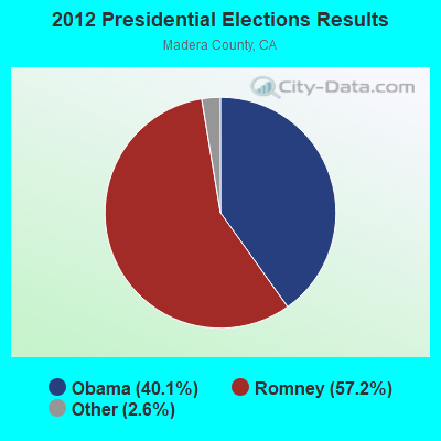
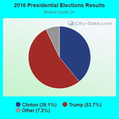

Graphs represent county-level data. Detailed 2008 Election Results
Religion statistics for Oakhurst-North Fork, CA (based on Madera County data)
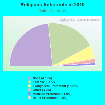

| Religion | Adherents | Congregations |
|---|---|---|
| Catholic | 56,566 | 3 |
| Evangelical Protestant | 15,077 | 89 |
| Other | 4,817 | 15 |
| Mainline Protestant | 2,808 | 14 |
| Black Protestant | 685 | 5 |
| None | 70,912 | - |
Food Environment Statistics:
| Madera County: | 2.06 / 10,000 pop. |
| State: | 2.14 / 10,000 pop. |
| Madera County: | 0.55 / 10,000 pop. |
| State: | 0.62 / 10,000 pop. |
| This county: | 3.23 / 10,000 pop. |
| California: | 1.49 / 10,000 pop. |
| Madera County: | 4.05 / 10,000 pop. |
| California: | 7.42 / 10,000 pop. |
| This county: | 7.6% |
| California: | 7.3% |
| This county: | 23.6% |
| California: | 21.3% |
| Here: | 15.5% |
| California: | 17.9% |
Strongest AM radio stations in Oakhurst-North Fork:
- KTNS (1060 AM; 5 kW; OAKHURST, CA; Owner: CALIFORNIA SIERRA CORPORATION)
- KMJ (580 AM; 50 kW; FRESNO, CA; Owner: INFINITY RADIO OPERATIONS INC.)
- KWRU (940 AM; 50 kW; FRESNO, CA)
- KOOR (790 AM; 10 kW; CLOVIS, CA; Owner: INFINITY RADIO OPERATIONS INC.)
- KCBC (770 AM; 50 kW; RIVERBANK, CA; Owner: KIERTRON, INC.)
- KXEX (1550 AM; 10 kW; FRESNO, CA; Owner: RAK COMMUNICATIONS, INC.)
- KAVT (1680 AM; 10 kW; FRESNO, CA; Owner: RAK COMMUNICATIONS, INC.)
- KIRV (1510 AM; daytime; 10 kW; FRESNO, CA; Owner: GORE-OVERGAARD BROADCASTING, INC)
- KFIG (1430 AM; 5 kW; FRESNO, CA; Owner: BIG DAWG BROADCASTING, LLC)
- KVVY (1580 AM; 10 kW; MERCED, CA; Owner: MAPLETON COMMUNICATIONS, LLC)
- KNBR (680 AM; 50 kW; SAN FRANCISCO, CA; Owner: KNBR LICO, INC.)
- KYNO (1300 AM; 5 kW; FRESNO, CA; Owner: SPANISH CATHOLIC RADIO OF FRESNO, LLC)
- KHTK (1140 AM; 50 kW; SACRAMENTO, CA; Owner: INFINITY RADIO SUBSIDIARY OPERATIONS INC.)
Strongest FM radio stations in Oakhurst-North Fork:
- KZOL (107.9 FM; NORTH FORK, CA; Owner: HBC LICENSE CORPORATION)
- KMMM (107.1 FM; MADERA, CA; Owner: ILLINOIS LOTUS CORP)
- KFNO (90.3 FM; FRESNO, CA; Owner: FAMILY STATIONS, INC.)
- KLBN (105.1 FM; AUBERRY, CA; Owner: LOTUS COMMUNICATIONS CORP.)
- KOQO-FM (101.9 FM; FRESNO, CA; Owner: INFINITY RADIO OPERATIONS INC.)
- KRNC (105.9 FM; FRESNO, CA; Owner: INFINITY RADIO OPERATIONS INC.)
- KSKS (93.7 FM; FRESNO, CA; Owner: INFINITY RADIO OPERATIONS INC.)
- K276BW (103.1 FM; NORTH FORK BASS LAKE, CA; Owner: CALIFORNIA SIERRA CORPORATION)
- KFCF (88.1 FM; FRESNO, CA; Owner: FRESNO FREE COLLEGE FOUNDATION)
- KVPR (89.3 FM; FRESNO, CA; Owner: WHITE ASH BROADCASTING, INC.)
- KDJK (103.9 FM; MARIPOSA, CA; Owner: CITADEL BROADCASTING COMPANY)
- KMGV (97.9 FM; FRESNO, CA; Owner: INFINITY RADIO OPERATIONS INC.)
- KAAT (103.1 FM; OAKHURST, CA; Owner: CALIFORNIA SIERRA CORPORATION)
- KEFR (89.9 FM; LE GRAND, CA; Owner: FAMILY STATIONS, INC.)
- KCIV (99.9 FM; MOUNT BULLION, CA; Owner: BOTT COMMUNICATIONS, INC.)
- KUBB (96.3 FM; MARIPOSA, CA; Owner: BUCKLEY BROADCASTING CORP. OF MONTEREY INC)
- KMPO (88.7 FM; MODESTO, CA; Owner: RADIO BILINGUE, INC.)
- KAMB (101.5 FM; MERCED, CA; Owner: CENTRAL VALLEY BROADCASTING CO. INC.)
- K214CT (90.7 FM; MARIPOSA, CA; Owner: CALVARY CHAPEL OF TWIN FALLS, INC.)
- KMMT (106.5 FM; MAMMOTH LAKES, CA; Owner: MAMMOTH MOUNTAIN FM ASSOCIATES,INC.)
TV broadcast stations around Oakhurst-North Fork:
- KHMM-CA (Channel 16; HANFORD, CA; Owner: CABALLERO TELEVISION TEXAS, L.L.C.)
- KNSO (Channel 51; MERCED, CA; Owner: TELEMUNDO OF FRESNO, LLC)
- KSEE (Channel 24; FRESNO, CA; Owner: KSEE LICENSE, INC.)
- KFRE-TV (Channel 59; SANGER, CA; Owner: SANGER TELECASTERS, INC.)
- KFSN-TV (Channel 30; FRESNO, CA; Owner: ABC, INC.)
- KGPE (Channel 47; FRESNO, CA; Owner: ACKERLEY BROADCASTING - FRESNO, LLC)
- KFTV (Channel 21; HANFORD, CA; Owner: KFTV LICENSE PARTNERSHIP, G.P.)
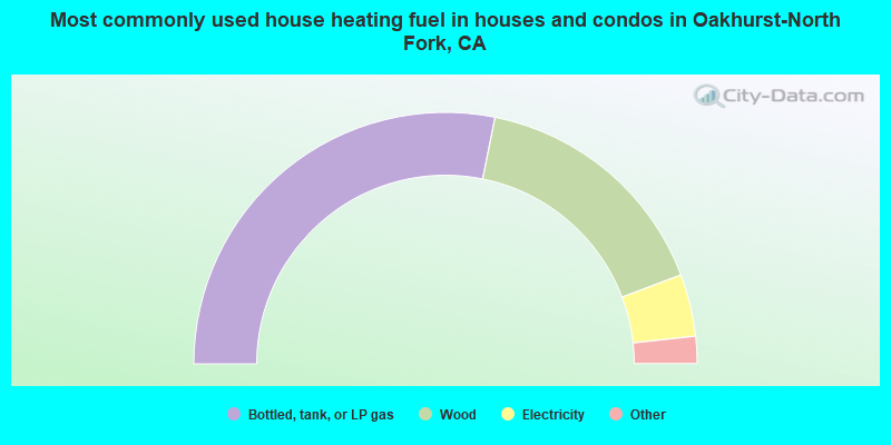
- 56.4%Bottled, tank, or LP gas
- 32.2%Wood
- 8.0%Electricity
- 1.5%Utility gas
- 1.3%Other fuel
- 0.2%No fuel used
- 0.2%Solar energy
- 0.1%Coal or coke
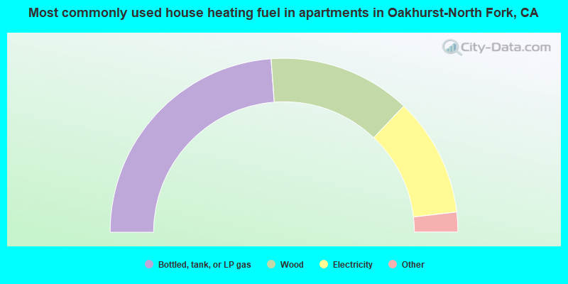
- 47.6%Bottled, tank, or LP gas
- 26.5%Wood
- 22.1%Electricity
- 3.0%Utility gas
- 0.4%Other fuel
- 0.3%No fuel used
Oakhurst-North Fork compared to California state average:
- Unemployed percentage below state average.
- Black race population percentage significantly below state average.
- Hispanic race population percentage significantly below state average.
- Median age significantly above state average.
- Foreign-born population percentage significantly below state average.
- Renting percentage below state average.
- Length of stay since moving in significantly above state average.
- Number of rooms per house significantly below state average.
- House age significantly below state average.
Oakhurst-North Fork on our top lists:
- #56 on the list of "Top 101 cities with largest percentage of males in industries: sewing, needlework, and piece goods stores (population 5,000+)"
- #57 on the list of "Top 101 cities with largest percentage of females in occupations: life, physical, and social science technicians (population 5,000+)"
- #61 on the list of "Top 101 cities with largest percentage of females in industries: rail transportation (population 5,000+)"
- #75 on the list of "Top 101 cities with largest percentage of males in occupations: transportation, tourism, and lodging attendants (population 5,000+)"
- #88 on the list of "Top 101 cities with largest percentage of females in occupations: other construction workers and helpers (population 5,000+)"
- #90 on the list of "Top 101 cities with largest percentage of females in occupations: other food preparation and serving workers including supervisors (population 5,000+)"
- #91 on the list of "Top 101 cities with largest percentage of females in industries: recyclable material merchant wholesalers (population 5,000+)"
- #94 on the list of "Top 100 cities with largest land areas"
- #14 on the list of "Top 101 counties with the highest Particulate Matter (PM10) Annual air pollution readings in 2012 (µg/m3)"
- #27 on the list of "Top 101 counties with the lowest surface withdrawal of fresh water for public supply (pop. 50,000+)"
- #29 on the list of "Top 101 counties with the highest Particulate Matter (PM2.5) Annual air pollution readings in 2012 (µg/m3)"
- #46 on the list of "Top 101 counties with the highest number of births per 1000 residents 2007-2013"
- #49 on the list of "Top 101 counties with the highest Nitrogen Dioxide air pollution readings in 2012 (ppm)"