Northwest Osage, Oklahoma
Submit your own pictures of this place and show them to the world
- OSM Map
- General Map
- Google Map
- MSN Map

| Males: 794 | |
| Females: 818 |
| Median resident age: | 41.8 years |
| Oklahoma median age: | 35.5 years |
Zip code: 74652
| Northwest Osage: | $48,575 |
| OK: | $59,673 |
Estimated per capita income in 2022: $29,092 (it was $16,903 in 2000)
Northwest Osage CCD income, earnings, and wages data
Estimated median house or condo value in 2022: $100,694 (it was $35,200 in 2000)
| Northwest Osage: | $100,694 |
| OK: | $191,700 |
Mean prices in 2022: all housing units: $218,021; detached houses: $234,628; townhouses or other attached units: $326,732; mobile homes: $109,203; occupied boats, rvs, vans, etc.: $26,836
Northwest Osage, OK residents, houses, and apartments details
Detailed information about poverty and poor residents in Northwest Osage, OK
Compare current foreclosures near Northwest Osage, OK:
| Photo | Address | Area | Beds / Baths | Price | Details |
|---|---|---|---|---|---|

|
#1
County Road 4297
Pawhuska, OK 74056
|
2,669 sq. feet
|
2 baths 2 beds |
$200,000
|
show details |

|
#2
Sandy Park Beach Rd
Burbank, OK 74633
|
1,953 sq. feet
|
2 baths 3 beds |
show details | |

|
#3
County Road 5501
Pawhuska, OK 74056
|
- sq. feet
|
- baths - beds |
show details | |

|
Check over 1 million property listings on Foreclosure.com!
|
browse all offers | |||

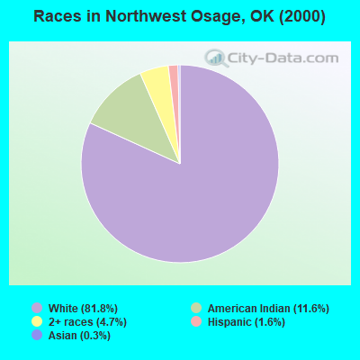
- 1,29881.8%White alone
- 18411.6%American Indian alone
- 754.7%Two or more races
- 261.6%Hispanic
- 40.3%Asian alone
Races in Northwest Osage detailed stats: ancestries, foreign born residents, place of birth
 Recent articles from our blog. Our writers, many of them Ph.D. graduates or candidates, create easy-to-read articles on a wide variety of topics.
Current Local Time: CST time zone
Land area: 423.3 square miles.
Population density: 3.8 people per square mile (very low).

| Northwest Osage CCD: | 0.6% ($199) |
| Oklahoma: | 0.8% ($523) |
Nearest city with pop. 50,000+: Tulsa, OK  (61.2 miles , pop. 393,049).
Nearest city with pop. 1,000,000+: Dallas, TX (276.3 miles , pop. 1,188,580).
Nearest cities:
), )Latitude: 36.79 N, Longitude: 96.67 W
Area code commonly used in this area: 918

| Here: | 3.9% |
| Oklahoma: | 3.2% |
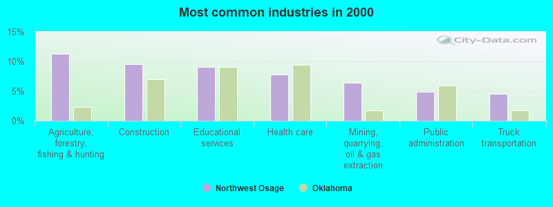
- Agriculture, forestry, fishing & hunting (11.3%)
- Construction (9.5%)
- Educational services (9.1%)
- Health care (7.8%)
- Mining, quarrying, oil & gas extraction (6.4%)
- Public administration (4.8%)
- Truck transportation (4.6%)
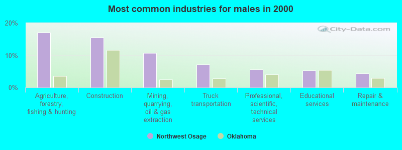
- Agriculture, forestry, fishing & hunting (17.0%)
- Construction (15.5%)
- Mining, quarrying, oil & gas extraction (10.7%)
- Truck transportation (7.1%)
- Professional, scientific, technical services (5.6%)
- Educational services (5.3%)
- Repair & maintenance (4.3%)
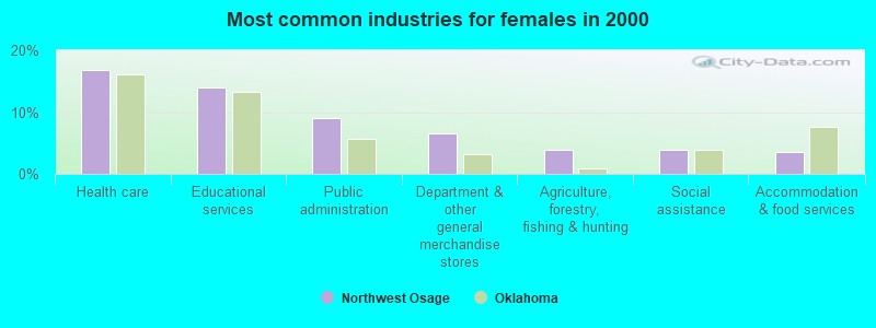
- Health care (16.9%)
- Educational services (14.0%)
- Public administration (9.1%)
- Department & other general merchandise stores (6.5%)
- Agriculture, forestry, fishing & hunting (3.9%)
- Social assistance (3.9%)
- Accommodation & food services (3.6%)
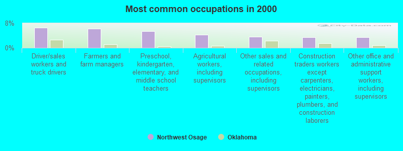
- Driver/sales workers and truck drivers (6.6%)
- Farmers and farm managers (6.3%)
- Preschool, kindergarten, elementary, and middle school teachers (5.4%)
- Agricultural workers, including supervisors (4.3%)
- Other sales and related occupations, including supervisors (3.6%)
- Construction traders workers except carpenters, electricians, painters, plumbers, and construction laborers (3.4%)
- Other office and administrative support workers, including supervisors (3.4%)
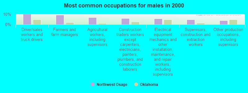
- Driver/sales workers and truck drivers (9.9%)
- Farmers and farm managers (9.4%)
- Agricultural workers, including supervisors (6.9%)
- Construction traders workers except carpenters, electricians, painters, plumbers, and construction laborers (6.1%)
- Electrical equipment mechanics and other installation, maintenance, and repair workers, including supervisors (5.8%)
- Supervisors, construction and extraction workers (4.8%)
- Other production occupations, including supervisors (3.8%)
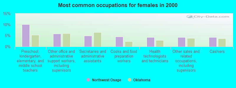
- Preschool, kindergarten, elementary, and middle school teachers (10.1%)
- Other office and administrative support workers, including supervisors (5.8%)
- Secretaries and administrative assistants (4.9%)
- Cooks and food preparation workers (4.5%)
- Health technologists and technicians (4.2%)
- Other sales and related occupations, including supervisors (4.2%)
- Cashiers (4.2%)
Average climate in Northwest Osage, Oklahoma
Based on data reported by over 4,000 weather stations


(lower is better)
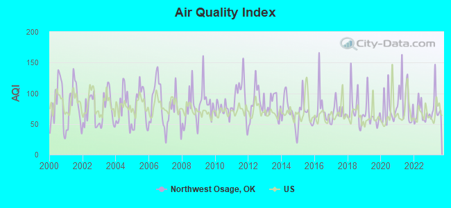
Air Quality Index (AQI) level in 2023 was 78.7. This is about average.
| City: | 78.7 |
| U.S.: | 72.6 |
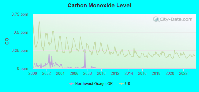
Carbon Monoxide (CO) [ppm] level in 2008 was 0.00714. This is significantly better than average. Closest monitor was 23.1 miles away from the city center.
| City: | 0.00714 |
| U.S.: | 0.25132 |
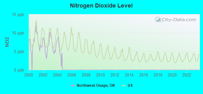
Nitrogen Dioxide (NO2) [ppb] level in 2004 was 4.78. This is about average. Closest monitor was 24.3 miles away from the city center.
| City: | 4.78 |
| U.S.: | 5.11 |
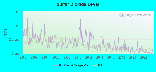
Sulfur Dioxide (SO2) [ppb] level in 2023 was 0.171. This is significantly better than average. Closest monitor was 23.1 miles away from the city center.
| City: | 0.171 |
| U.S.: | 1.515 |
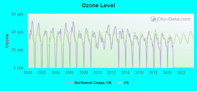
Ozone [ppb] level in 2020 was 29.3. This is about average. Closest monitor was 20.0 miles away from the city center.
| City: | 29.3 |
| U.S.: | 33.3 |
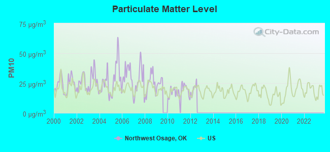
Particulate Matter (PM10) [µg/m3] level in 2012 was 20.0. This is about average. Closest monitor was 20.0 miles away from the city center.
| City: | 20.0 |
| U.S.: | 19.2 |
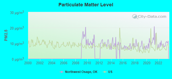
Particulate Matter (PM2.5) [µg/m3] level in 2023 was 10.0. This is worse than average. Closest monitor was 23.1 miles away from the city center.
| City: | 10.0 |
| U.S.: | 8.1 |
Tornado activity:
Northwest Osage-area historical tornado activity is near Oklahoma state average. It is 132% greater than the overall U.S. average.
On 5/25/1955, a category F5 (max. wind speeds 261-318 mph) tornado 27.4 miles away from the Northwest Osage place center killed 80 people and injured 273 people and caused between $50,000 and $500,000 in damages.
On 4/26/1991, a category F4 (max. wind speeds 207-260 mph) tornado 13.7 miles away from the place center injured 6 people and caused between $500,000 and $5,000,000 in damages.
Earthquake activity:
Northwest Osage-area historical earthquake activity is significantly above Oklahoma state average. It is 869% greater than the overall U.S. average.On 9/3/2016 at 12:02:44, a magnitude 5.8 (5.8 MW, Depth: 3.5 mi, Class: Moderate, Intensity: VI - VII) earthquake occurred 29.3 miles away from the city center
On 11/6/2011 at 03:53:10, a magnitude 5.7 (5.7 MW, Depth: 3.2 mi) earthquake occurred 87.4 miles away from Northwest Osage center
On 11/7/2016 at 01:44:24, a magnitude 5.0 (5.0 MW, Depth: 2.8 mi) earthquake occurred 56.0 miles away from the city center
On 11/12/2014 at 21:40:00, a magnitude 4.9 (4.9 MW, Depth: 2.5 mi, Class: Light, Intensity: IV - V) earthquake occurred 62.2 miles away from Northwest Osage center
On 2/13/2016 at 17:07:06, a magnitude 5.1 (5.1 MW, Depth: 5.2 mi) earthquake occurred 115.3 miles away from the city center
On 11/5/2011 at 07:12:45, a magnitude 4.8 (4.8 MW, Depth: 1.9 mi) earthquake occurred 86.2 miles away from Northwest Osage center
Magnitude types: moment magnitude (MW)
Natural disasters:
The number of natural disasters in Osage County (35) is a lot greater than the US average (15).Major Disasters (Presidential) Declared: 25
Emergencies Declared: 5
Causes of natural disasters: Floods: 16, Storms: 16, Tornadoes: 11, Winter Storms: 10, Winds: 4, Fires: 3, Heavy Rains: 2, Ice Storms: 2, Hurricane: 1, Snowstorm: 1, Other: 1 (Note: some incidents may be assigned to more than one category).
Colleges/universities with over 2000 students nearest to Northwest Osage:
- Cowley County Community College (about 28 miles; Arkansas City, KS; Full-time enrollment: 3,173)
- Northern Oklahoma College (about 36 miles; Tonkawa, OK; FT enrollment: 3,414)
- Oklahoma State University-Main Campus (about 52 miles; Stillwater, OK; FT enrollment: 21,700)
- University of Tulsa (about 60 miles; Tulsa, OK; FT enrollment: 3,702)
- Tulsa Community College (about 64 miles; Tulsa, OK; FT enrollment: 12,480)
- Oral Roberts University (about 65 miles; Tulsa, OK; FT enrollment: 3,216)
- Rogers State University (about 67 miles; Claremore, OK; FT enrollment: 3,482)
Points of interest:
Notable locations in Northwest Osage: T-Apple Ranch (A), Lakeview Golf Course (B), Codding Ranch (C), Sarge Creek Rural Fire Company (D), Antelope Creek Rural Fire Department (E), Burbank Volunteer Fire Department (F), Big Beaver Fire Department (G), Shidler Fire and Emergency Medical Services (H), Shidler Volunteer Fire Department (I), Lost Man Creek Rural Fire Company (J), Webb City Volunteer Fire Department (K), Bar - C Volunteer Fire Department (L), Frankfort Rural Fire Company (M), Blackland Fire Corporation (N), Grainola Volunteer Fire Department (O), Foraker Volunteer Fire Department (P), Wamsley Creek Rural Fire Department (Q), Lyman Rural Fire Company (R), Denoya Rural Firefighters (S), Buckcreek Rural Fire Department (T). Display/hide their locations on the map
Cemeteries: Foraker Cemetery (1), Burbank Cemetery (2), Saint Johns Cemetery (3). Display/hide their locations on the map
Reservoirs: Charlotte Lake (A), Kaw Lake (B), Big Caney Creek Site 11 Reservoir (C), Oknoname 113052 Reservoir (D), Oknoname 113127 Reservoir (E), Adams Ranch Airport Lake (F), Oknoname 113130 Reservoir (G), Phillips Lake (H). Display/hide their locations on the map
Creeks: Wamsley Creek (A), Hickory Creek (B), Hay Creek (C), Bayliss Creek (D), Antelope Creek (E), Stewart Creek (F), Spring Creek (G), South Buck Creek (H), Charley Creek (I). Display/hide their locations on the map
| This place: | 2.4 people |
| Oklahoma: | 2.5 people |
| This place: | 72.7% |
| Whole state: | 66.8% |
| This place: | 5.8% |
| Whole state: | 5.9% |
No gay or lesbian households reported
| This place: | 15.7% |
| Whole state: | 14.7% |
| This place: | 6.4% |
| Whole state: | 6.1% |
4 people in group homes intended for adults in 2010
For population 15 years and over in Northwest Osage:
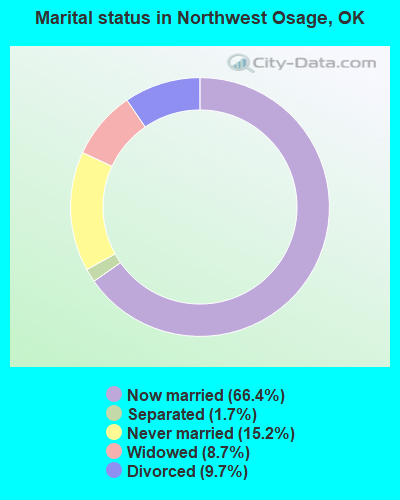
- Never married: 15.2%
- Now married: 66.4%
- Separated: 1.7%
- Widowed: 8.7%
- Divorced: 9.7%
For population 25 years and over in Northwest Osage:
- High school or higher: 82.1%
- Bachelor's degree or higher: 12.0%
- Graduate or professional degree: 3.5%
- Unemployed: 5.4%
- Mean travel time to work (commute): 25.1 minutes

| Here: | 9.5 |
| Oklahoma average: | 11.7 |
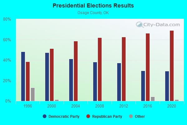
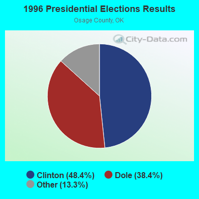
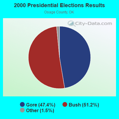
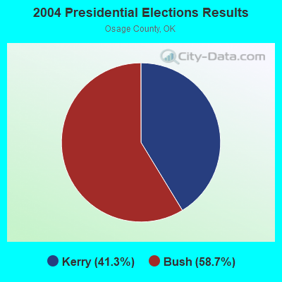
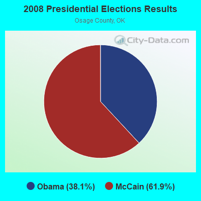
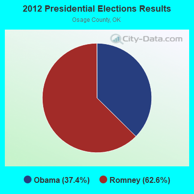
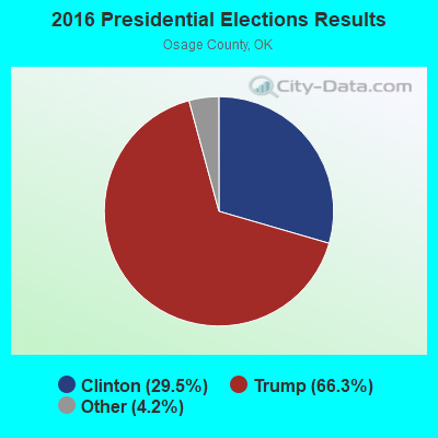
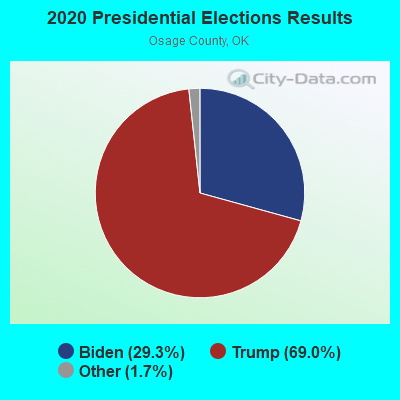
Graphs represent county-level data. Detailed 2008 Election Results
Religion statistics for Northwest Osage, OK (based on Osage County data)
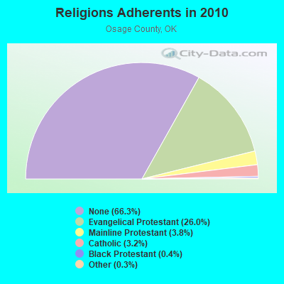
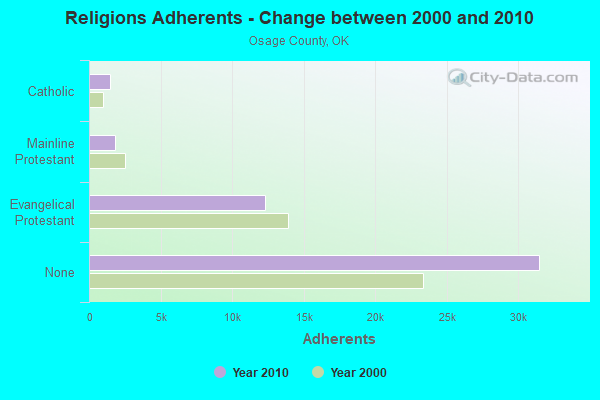
| Religion | Adherents | Congregations |
|---|---|---|
| Evangelical Protestant | 12,337 | 54 |
| Mainline Protestant | 1,783 | 15 |
| Catholic | 1,500 | 7 |
| Black Protestant | 209 | 2 |
| Other | 150 | 2 |
| None | 31,493 | - |
Food Environment Statistics:
| This county: | 0.66 / 10,000 pop. |
| State: | 1.97 / 10,000 pop. |
| Here: | 0.88 / 10,000 pop. |
| Oklahoma: | 0.76 / 10,000 pop. |
| Osage County: | 4.40 / 10,000 pop. |
| Oklahoma: | 4.35 / 10,000 pop. |
| Here: | 4.62 / 10,000 pop. |
| Oklahoma: | 6.89 / 10,000 pop. |
| Here: | 11.2% |
| Oklahoma: | 10.3% |
| Osage County: | 31.3% |
| Oklahoma: | 29.2% |
Strongest AM radio stations in Northwest Osage:
- KRMG (740 AM; 50 kW; TULSA, OK; Owner: CXR HOLDINGS, INC.)
- KFAQ (1170 AM; 50 kW; TULSA, OK; Owner: JOURNAL BROADCAST CORPORATION)
- KTBZ (1430 AM; 25 kW; TULSA, OK; Owner: CLEAR CHANNEL BROADCASTING LICENSES, INC.)
- KMUS (1380 AM; 20 kW; MUSKOGEE, OK; Owner: ABC, INC.)
- KGGF (690 AM; 10 kW; COFFEYVILLE, KS; Owner: KGGF-KUSN, INC.)
- KOMA (1520 AM; 50 kW; OKLAHOMA CITY, OK; Owner: RENDA BROADCASTING CORP. OF NEVADA)
- WBBZ (1230 AM; 1 kW; PONCA CITY, OK; Owner: PONCA CITY PUBLISHING CO.)
- KFTI (1070 AM; 10 kW; WICHITA, KS; Owner: JOURNAL BROADCAST CORPORATION)
- KCRC (1390 AM; 10 kW; ENID, OK; Owner: CHISHOLM TRAIL BROADCASTING CO.)
- WHB (810 AM; 50 kW; KANSAS CITY, MO; Owner: UNION BROADCASTING, INC.)
- KSOK (1280 AM; daytime; 1 kW; ARKANSAS CITY, KS; Owner: COWLEY COUNTY BROADCASTING, INC.)
- KCFO (970 AM; 2 kW; TULSA, OK; Owner: FRIENDSHIP BROADCASTING, L. P.)
- KKOW (860 AM; 10 kW; PITTSBURG, KS; Owner: AMERICAN MEDIA INVESTMENTS)
Strongest FM radio stations in Northwest Osage:
- KYFM (100.1 FM; BARTLESVILLE, OK; Owner: KCD ENTERPRISES, INC.)
- KYQQ (106.5 FM; ARKANSAS CITY, KS; Owner: JOURNAL BROADCAST CORPORATION)
- KBVL (103.9 FM; PAWHUSKA, OK; Owner: BORGEN BROADCASTING COMPANY)
- KSOK-FM (95.9 FM; WINFIELD, KS; Owner: COWLEY COUNTY BROADCASTING, INC.)
- KLVV (88.7 FM; PONCA CITY, OK; Owner: THE LOVE STATION, INC.)
- KAXR (91.3 FM; ARKANSAS CITY, KS; Owner: AMERICAN FAMILY ASSOCIATION)
- KIXR (104.7 FM; PONCA CITY, OK; Owner: MUR-THOM BROADCASTING, INC.)
- KACY (102.5 FM; ARKANSAS CITY, KS; Owner: THIRD COAST BROADCASTING, INC.)
- KLOR-FM (99.3 FM; PONCA CITY, OK; Owner: TEAM RADIO LLC)
TV broadcast stations around Northwest Osage:
- K54FZ (Channel 54; PONCA CITY, OK; Owner: LOCKE SUPPLY CO.)
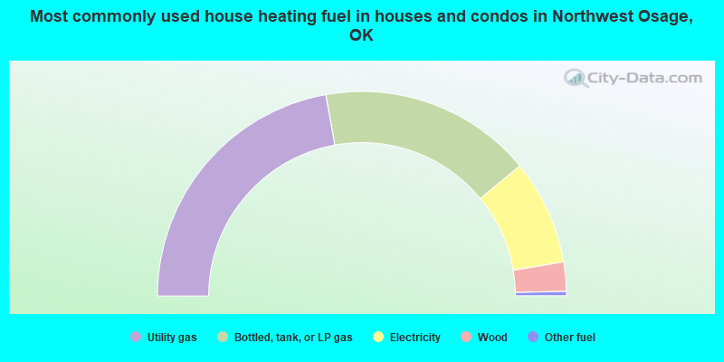
- 44.3%Utility gas
- 33.7%Bottled, tank, or LP gas
- 16.6%Electricity
- 4.6%Wood
- 0.7%Other fuel
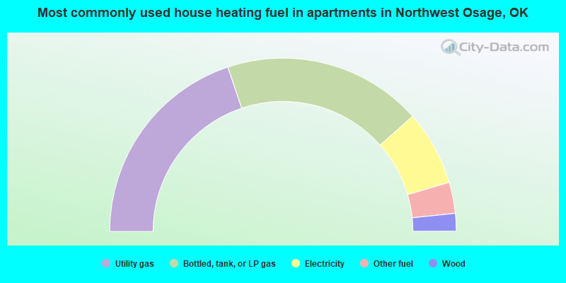
- 39.7%Utility gas
- 37.2%Bottled, tank, or LP gas
- 14.0%Electricity
- 5.8%Other fuel
- 3.3%Wood
Northwest Osage compared to Oklahoma state average:
- Median house value below state average.
- Unemployed percentage below state average.
- Black race population percentage significantly below state average.
- Hispanic race population percentage significantly below state average.
- Median age above state average.
- Foreign-born population percentage significantly below state average.
- Renting percentage below state average.
- Length of stay since moving in significantly above state average.
- Number of rooms per house significantly below state average.
- House age significantly below state average.
- Percentage of population with a bachelor's degree or higher below state average.