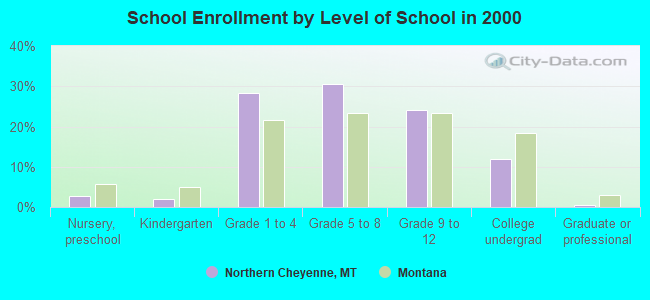
Northern Cheyenne, Montana
Submit your own pictures of this place and show them to the world
- OSM Map
- General Map
- Google Map
- MSN Map

| Males: 772 | |
| Females: 781 |
| Median resident age: | 22.7 years |
| Montana median age: | 37.5 years |
Zip code: 59016
| Northern Cheyenne: | $54,312 |
| MT: | $67,631 |
Estimated per capita income in 2022: $14,986 (it was $7,307 in 2000)
Northern Cheyenne CCD income, earnings, and wages data
Estimated median house or condo value in 2022: $164,942 (it was $51,100 in 2000)
| Northern Cheyenne: | $164,942 |
| MT: | $366,400 |
Mean prices in 2022: all housing units: $207,922; detached houses: $239,562; townhouses or other attached units: $150,967; mobile homes: $58,448
Northern Cheyenne, MT residents, houses, and apartments details
Detailed information about poverty and poor residents in Northern Cheyenne, MT


- 1,36188.3%American Indian alone
- 1056.8%White alone
- 463.0%Hispanic
- 301.9%Two or more races
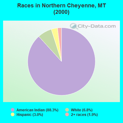
Races in Northern Cheyenne detailed stats: ancestries, foreign born residents, place of birth
 Recent articles from our blog. Our writers, many of them Ph.D. graduates or candidates, create easy-to-read articles on a wide variety of topics.
Current Local Time: MST time zone
Land area: 318.4 square miles.
Population density: 4.9 people per square mile (very low).

| Northern Cheyenne CCD: | 1.1% ($547) |
| Montana: | 1.3% ($1,212) |
Nearest city with pop. 50,000+: Billings, MT  (80.9 miles , pop. 89,847).
Nearest city with pop. 200,000+: West Adams, CO (402.2 miles , pop. 259,628).
Nearest city with pop. 1,000,000+: Phoenix, AZ (873.4 miles , pop. 1,321,045).
Nearest cities:
), ), ), Latitude: 45.52 N, Longitude: 106.91 W
Area code commonly used in this area: 406

| Here: | 5.7% |
| Montana: | 3.8% |
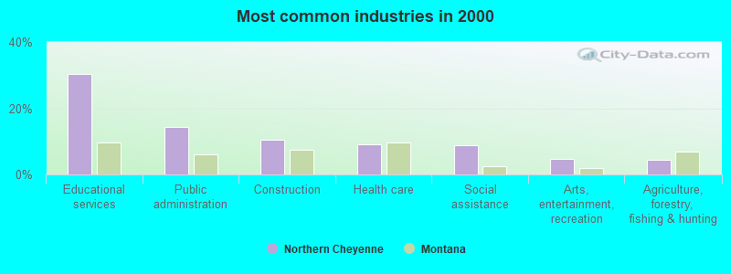
- Educational services (30.3%)
- Public administration (14.2%)
- Construction (10.6%)
- Health care (9.2%)
- Social assistance (8.9%)
- Arts, entertainment, recreation (4.6%)
- Agriculture, forestry, fishing & hunting (4.4%)
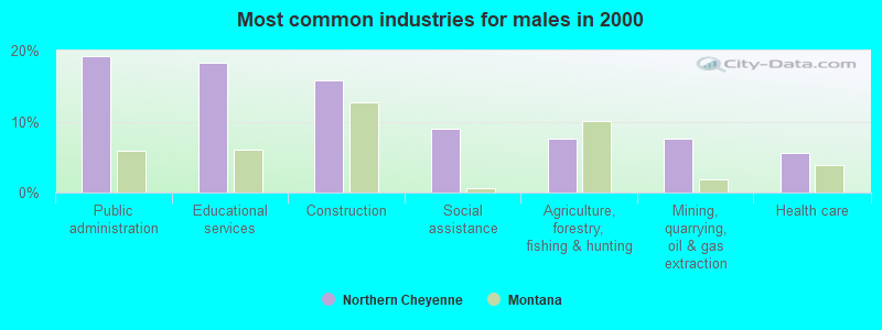
- Public administration (19.1%)
- Educational services (18.3%)
- Construction (15.7%)
- Social assistance (8.9%)
- Agriculture, forestry, fishing & hunting (7.7%)
- Mining, quarrying, oil & gas extraction (7.7%)
- Health care (5.5%)
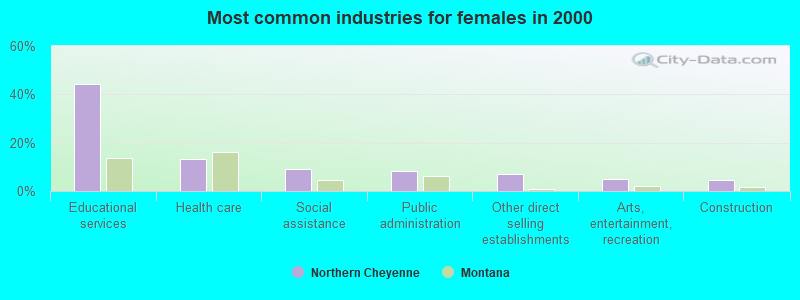
- Educational services (44.3%)
- Health care (13.4%)
- Social assistance (9.0%)
- Public administration (8.5%)
- Other direct selling establishments (7.0%)
- Arts, entertainment, recreation (5.0%)
- Construction (4.5%)
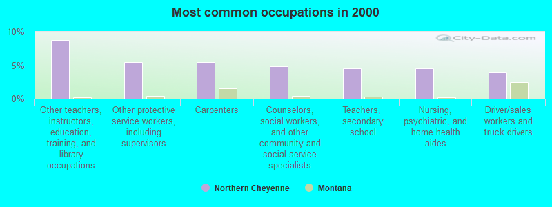
- Other teachers, instructors, education, training, and library occupations (8.7%)
- Other protective service workers, including supervisors (5.5%)
- Carpenters (5.5%)
- Counselors, social workers, and other community and social service specialists (4.8%)
- Teachers, secondary school (4.6%)
- Nursing, psychiatric, and home health aides (4.6%)
- Driver/sales workers and truck drivers (3.9%)
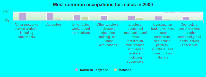
- Other protective service workers, including supervisors (10.2%)
- Carpenters (10.2%)
- Driver/sales workers and truck drivers (7.2%)
- Other teachers, instructors, education, training, and library occupations (6.8%)
- Electrical equipment mechanics and other installation, maintenance, and repair workers, including supervisors (6.4%)
- Construction traders workers except carpenters, electricians, painters, plumbers, and construction laborers (6.0%)
- Counselors, social workers, and other community and social service specialists (5.5%)
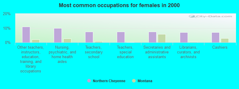
- Other teachers, instructors, education, training, and library occupations (10.9%)
- Nursing, psychiatric, and home health aides (10.0%)
- Teachers, secondary school (7.5%)
- Teachers, special education (7.5%)
- Secretaries and administrative assistants (7.5%)
- Librarians, curators, and archivists (7.0%)
- Cashiers (7.0%)
Average climate in Northern Cheyenne, Montana
Based on data reported by over 4,000 weather stations


(lower is better)
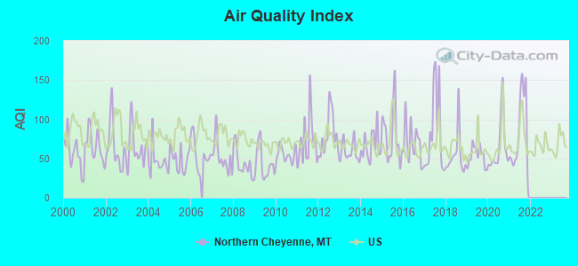
Air Quality Index (AQI) level in 2021 was 84.3. This is about average.
| City: | 84.3 |
| U.S.: | 72.6 |
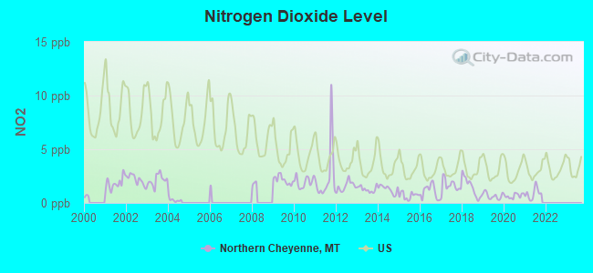
Nitrogen Dioxide (NO2) [ppb] level in 2021 was 0.800. This is significantly better than average. Closest monitor was 19.3 miles away from the city center.
| City: | 0.800 |
| U.S.: | 5.109 |
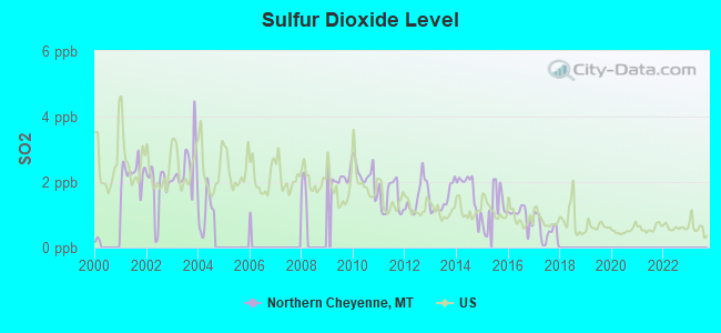
Sulfur Dioxide (SO2) [ppb] level in 2017 was 0.541. This is significantly better than average. Closest monitor was 19.3 miles away from the city center.
| City: | 0.541 |
| U.S.: | 1.515 |
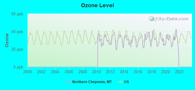
Ozone [ppb] level in 2021 was 31.5. This is about average. Closest monitor was 22.9 miles away from the city center.
| City: | 31.5 |
| U.S.: | 33.3 |
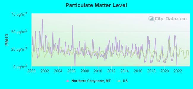
Particulate Matter (PM10) [µg/m3] level in 2021 was 23.0. This is about average. Closest monitor was 13.7 miles away from the city center.
| City: | 23.0 |
| U.S.: | 19.2 |
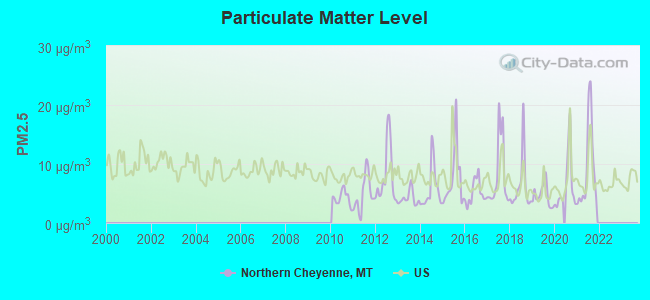
Particulate Matter (PM2.5) [µg/m3] level in 2021 was 9.24. This is about average. Closest monitor was 13.7 miles away from the city center.
| City: | 9.24 |
| U.S.: | 8.11 |
Earthquake activity:
Northern Cheyenne-area historical earthquake activity is significantly above Montana state average. It is 477% greater than the overall U.S. average.On 8/18/1959 at 06:37:13, a magnitude 7.7 (7.7 UK, Class: Major, Intensity: VIII - XII) earthquake occurred 194.5 miles away from the city center, causing $26,000,000 total damage
On 10/28/1983 at 14:06:06, a magnitude 7.3 (6.2 MB, 7.3 MS, 7.0 MW) earthquake occurred 352.6 miles away from Northern Cheyenne center, causing 2 deaths (2 shaking deaths) and 3 injuries, causing $15,000,000 total damage
On 6/30/1975 at 18:54:13, a magnitude 6.1 (5.6 MB, 5.9 MS, 6.1 UK, 6.1 ML, Class: Strong, Intensity: VII - IX) earthquake occurred 195.8 miles away from Northern Cheyenne center
On 9/8/1984 at 00:59:31, a magnitude 5.1 (5.1 MB, Class: Moderate, Intensity: VI - VII) earthquake occurred 101.3 miles away from the city center
On 5/29/1984 at 20:18:32, a magnitude 5.0 (5.0 MB) earthquake occurred 100.2 miles away from the city center
On 2/3/1994 at 09:05:04, a magnitude 5.8 (5.4 MB, 5.5 MS, 5.8 MW, 5.8 ML, Depth: 4.9 mi) earthquake occurred 276.4 miles away from Northern Cheyenne center
Magnitude types: body-wave magnitude (MB), local magnitude (ML), surface-wave magnitude (MS), moment magnitude (MW)
Natural disasters:
The number of natural disasters in Big Horn County (6) is a lot smaller than the US average (15).Major Disasters (Presidential) Declared: 4
Emergencies Declared: 1
Causes of natural disasters: Storms: 3, Floods: 2, Fire: 1, Hurricane: 1, Other: 1 (Note: some incidents may be assigned to more than one category).
Colleges/universities with over 2000 students nearest to Northern Cheyenne:
- Sheridan College (about 53 miles; Sheridan, WY; Full-time enrollment: 2,070)
- Montana State University-Billings (about 81 miles; Billings, MT; FT enrollment: 4,319)
- Black Hills State University (about 165 miles; Spearfish, SD; FT enrollment: 3,166)
- Casper College (about 189 miles; Casper, WY; FT enrollment: 2,770)
- Montana State University (about 201 miles; Bozeman, MT; FT enrollment: 12,942)
- South Dakota School of Mines and Technology (about 208 miles; Rapid City, SD; FT enrollment: 2,102)
- Brigham Young University-Idaho (about 268 miles; Rexburg, ID; FT enrollment: 30,522)
Points of interest:
Notable locations in Northern Cheyenne: Black Spring Lookout (A), Brown Camp (B), Bull Creek Lookout (C). Display/hide their locations on the map
Churches in Northern Cheyenne include: Christ the King Church (A), White River Mennonite Church (B), Muddy Creek Church (C). Display/hide their locations on the map
Cemeteries: Busby Cemetery (1), Muddy Creek Cemetery (2). Display/hide their locations on the map
Lakes and reservoirs: Little Hawk Lake (A), Muddy Lake (B), Two Moon Reservoir (C), Rednose Reservoir (D). Display/hide their locations on the map
Streams, rivers, and creeks: Ash Creek (A), Bear Creek (B), Bee Creek (C), Black Canyon Creek (D), Black Whiteman Creek (E), Brady Creek (F), Busby Creek (G), Butte Creek (H), Coal Creek (I). Display/hide their locations on the map
Park in Northern Cheyenne: Indian Chief Two Moons Historical Monument (1). Display/hide its location on the map
| This place: | 3.9 people |
| Montana: | 2.4 people |
| This place: | 83.0% |
| Whole state: | 62.8% |
| This place: | 11.6% |
| Whole state: | 6.7% |
Likely homosexual households (counted as self-reported same-sex unmarried-partner households)
- Lesbian couples: 1.2% of all households
- Gay men: 1.2% of all households
| This place: | 45.0% |
| Whole state: | 14.6% |
| This place: | 14.4% |
| Whole state: | 5.8% |
4 people in agriculture workers' dormitories on farms in 2000
For population 15 years and over in Northern Cheyenne:
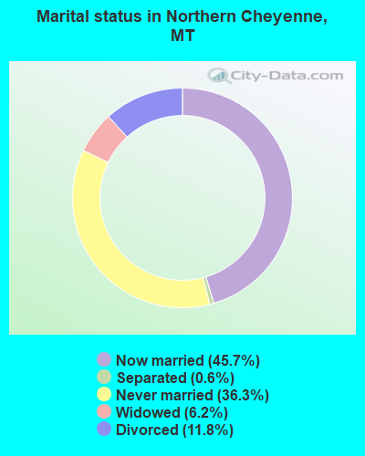
- Never married: 36.3%
- Now married: 45.7%
- Separated: 0.6%
- Widowed: 6.2%
- Divorced: 11.8%
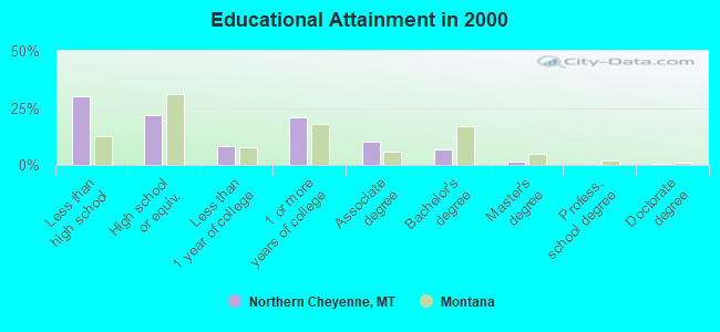
For population 25 years and over in Northern Cheyenne:
- High school or higher: 69.9%
- Bachelor's degree or higher: 8.7%
- Graduate or professional degree: 1.8%
- Unemployed: 16.8%
- Mean travel time to work (commute): 19.1 minutes
| Here: | 9.7 |
| Montana average: | 10.4 |
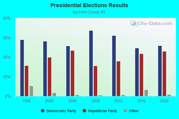
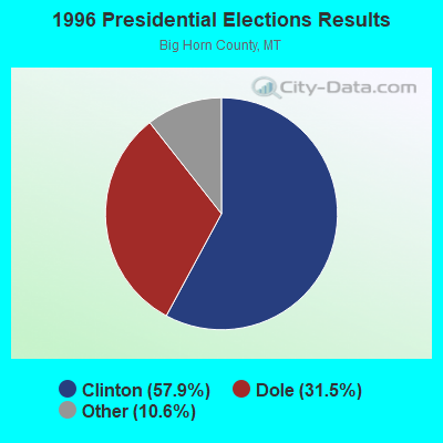
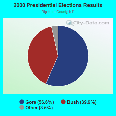
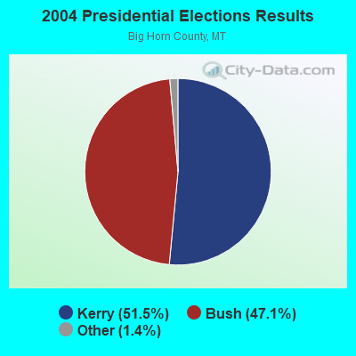
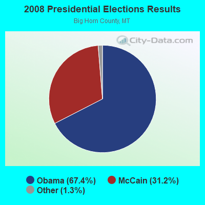
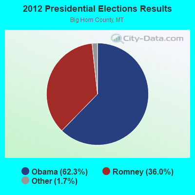
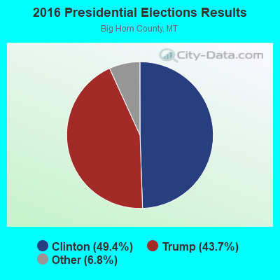
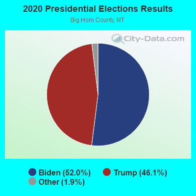
Graphs represent county-level data. Detailed 2008 Election Results
Religion statistics for Northern Cheyenne, MT (based on Big Horn County data)
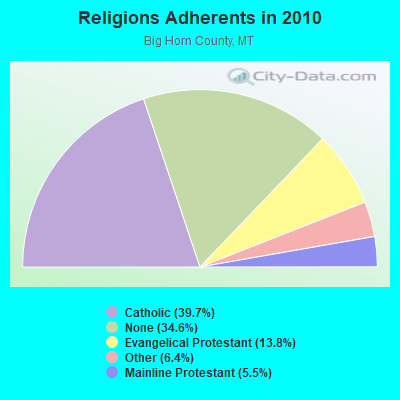
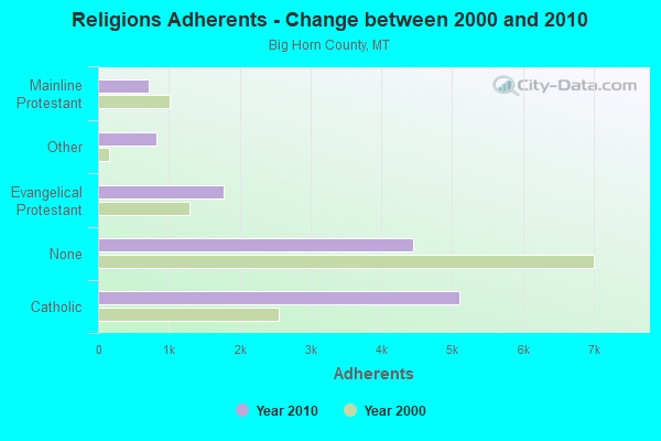
| Religion | Adherents | Congregations |
|---|---|---|
| Catholic | 5,102 | 6 |
| Evangelical Protestant | 1,770 | 21 |
| Other | 825 | 4 |
| Mainline Protestant | 711 | 8 |
| None | 4,457 | - |
Food Environment Statistics:
| Big Horn County: | 2.35 / 10,000 pop. |
| Montana: | 2.55 / 10,000 pop. |
| Here: | 0.78 / 10,000 pop. |
| State: | 0.48 / 10,000 pop. |
| This county: | 10.18 / 10,000 pop. |
| Montana: | 4.69 / 10,000 pop. |
| This county: | 5.48 / 10,000 pop. |
| Montana: | 10.38 / 10,000 pop. |
| This county: | 11.6% |
| Montana: | 7.2% |
| Big Horn County: | 32.4% |
| State: | 23.1% |
| Big Horn County: | 19.8% |
| Montana: | 10.7% |
Strongest AM radio stations in Northern Cheyenne:
- KROE (930 AM; 5 kW; SHERIDAN, WY; Owner: LOVCOM, INC.)
- KATL (770 AM; 10 kW; MILES CITY, MT; Owner: STAR PRINTING COMPANY)
- KIKC (1250 AM; 5 kW; FORSYTH, MT; Owner: MILES CITY, FORSYTH B/DCSTG, INC.)
- KMTA (1050 AM; 10 kW; MILES CITY, MT; Owner: SENGER BROADCASTING CORPORATION)
- KTWO (1030 AM; 50 kW; CASPER, WY; Owner: CITICASTERS LICENSES, L.P.)
- KWYO (1410 AM; 5 kW; SHERIDAN, WY; Owner: KWYO AM, LLC)
- KURL (730 AM; 5 kW; BILLINGS, MT; Owner: ELENBAAS MEDIA, INC.)
- KZMQ (1140 AM; daytime; 10 kW; GREYBULL, WY; Owner: LEGEND COMMUNICATIONS OF WYOMING LLC)
- KGHL (790 AM; 5 kW; BILLINGS, MT; Owner: NEW NORTHWEST BROADCASTERS, LLC)
- KBHB (810 AM; 25 kW; STURGIS, SD; Owner: MONTEREY LICENSES, LLC)
- KUYO (830 AM; daytime; 25 kW; EVANSVILLE, WY; Owner: WYOMING CHRISTIAN BROADCASTING COMPANY)
- KBUL (970 AM; 5 kW; BILLINGS, MT; Owner: CAPSTAR TX LIMITED PARTNERSHIP)
- KXMR (710 AM; 50 kW; BISMARCK, ND; Owner: RADIO BISMARCK MANDAN, LLC)
Strongest FM radio stations in Northern Cheyenne:
- KMHK (95.5 FM; HARDIN, MT; Owner: CAPSTAR TX LIMITED PARTNERSHIP)
- K244CK (96.7 FM; COWLEY, ETC., WY; Owner: CONNECTION COMMUNICATIONS ASSOC., INC.)
- KMCJ (99.5 FM; COLSTRIP, MT; Owner: HI-LINE RADIO FELLOWSHIP, INC.)
- KZMQ-FM (100.3 FM; GREYBULL, WY; Owner: LEGEND COMMUNICATIONS OF WYOMING LLC)
TV broadcast stations around Northern Cheyenne:
- K07TR (Channel 7; NO.CHEYENNE IND. RES, MT; Owner: DULL KNIFE MEMORIAL COLLEGE)
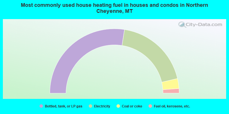
- 55.0%Bottled, tank, or LP gas
- 37.8%Electricity
- 5.0%Coal or coke
- 2.3%Fuel oil, kerosene, etc.
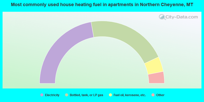
- 44.4%Electricity
- 41.7%Bottled, tank, or LP gas
- 7.8%Fuel oil, kerosene, etc.
- 2.2%Coal or coke
- 2.2%Wood
- 1.7%Other fuel
Northern Cheyenne compared to Montana state average:
- Median house value below state average.
- Black race population percentage significantly below state average.
- Median age significantly below state average.
- Foreign-born population percentage significantly below state average.
- Length of stay since moving in significantly above state average.
- Number of rooms per house significantly below state average.
- House age significantly below state average.
- Percentage of population with a bachelor's degree or higher significantly below state average.