Northeast Ellis, Oklahoma
Submit your own pictures of this place and show them to the world
- OSM Map
- General Map
- Google Map
- MSN Map

| Males: 550 | |
| Females: 578 |
| Median resident age: | 41.6 years |
| Oklahoma median age: | 35.5 years |
Zip code: 73840
| Northeast Ellis: | $54,683 |
| OK: | $59,673 |
Estimated per capita income in 2022: $29,120 (it was $15,635 in 2000)
Northeast Ellis CCD income, earnings, and wages data
Estimated median house or condo value in 2022: $111,161 (it was $34,900 in 2000)
| Northeast Ellis: | $111,161 |
| OK: | $191,700 |
Mean prices in 2022: all housing units: $194,013; detached houses: $191,157; townhouses or other attached units: $240,390; mobile homes: $198,853
Northeast Ellis, OK residents, houses, and apartments details
Detailed information about poverty and poor residents in Northeast Ellis, OK
Compare current foreclosures near Northeast Ellis, OK:
| Photo | Address | Area | Beds / Baths | Price | Details |
|---|---|---|---|---|---|

|
#1
S County Road 186
Fargo, OK 73840
|
- sq. feet
|
2 baths 3 beds |
show details | |

|
#2
S Dewey
Gage, OK 73843
|
- sq. feet
|
- baths - beds |
show details | |

|
#3
E County Road 50
Shattuck, OK 73858
|
- sq. feet
|
- baths - beds |
show details | |

|
Check over 1 million property listings on Foreclosure.com!
|
browse all offers | |||

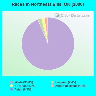
- 1,11393.6%White alone
- 282.4%Hispanic
- 231.9%Two or more races
- 211.8%American Indian alone
- 40.3%Asian alone
Races in Northeast Ellis detailed stats: ancestries, foreign born residents, place of birth
 Recent articles from our blog. Our writers, many of them Ph.D. graduates or candidates, create easy-to-read articles on a wide variety of topics.
Current Local Time: CST time zone
Land area: 265.5 square miles.
Population density: 4.2 people per square mile (very low).

| Northeast Ellis CCD: | 0.6% ($199) |
| Oklahoma: | 0.8% ($523) |
Nearest city with pop. 50,000+: East Canadian, OK (127.4 miles  , pop. 61,645).
Nearest city with pop. 200,000+: Oklahoma City, OK (137.6 miles , pop. 506,132).
Nearest city with pop. 1,000,000+: Dallas, TX (299.7 miles , pop. 1,188,580).
Nearest cities:
), ), ), ), )Latitude: 36.40 N, Longitude: 99.71 W
Area code commonly used in this area: 580

| Here: | 2.3% |
| Oklahoma: | 3.2% |
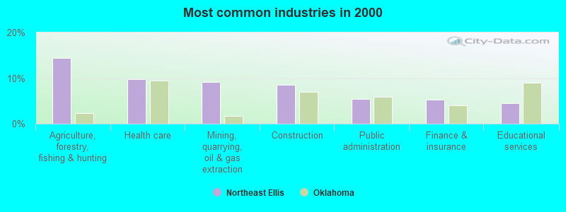
- Agriculture, forestry, fishing & hunting (14.5%)
- Health care (9.8%)
- Mining, quarrying, oil & gas extraction (9.1%)
- Construction (8.6%)
- Public administration (5.4%)
- Finance & insurance (5.2%)
- Educational services (4.5%)
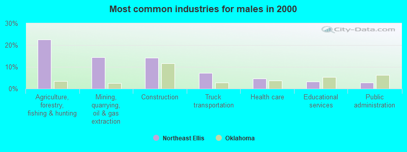
- Agriculture, forestry, fishing & hunting (22.6%)
- Mining, quarrying, oil & gas extraction (14.5%)
- Construction (14.2%)
- Truck transportation (7.2%)
- Health care (4.7%)
- Educational services (3.1%)
- Public administration (2.8%)
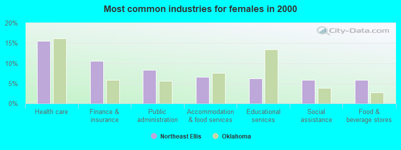
- Health care (15.6%)
- Finance & insurance (10.5%)
- Public administration (8.3%)
- Accommodation & food services (6.5%)
- Educational services (6.2%)
- Social assistance (5.8%)
- Food & beverage stores (5.8%)
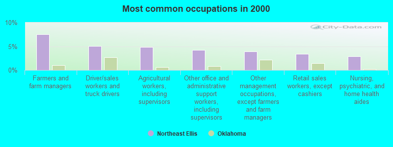
- Farmers and farm managers (7.6%)
- Driver/sales workers and truck drivers (5.1%)
- Agricultural workers, including supervisors (4.9%)
- Other office and administrative support workers, including supervisors (4.2%)
- Other management occupations, except farmers and farm managers (3.9%)
- Retail sales workers, except cashiers (3.4%)
- Nursing, psychiatric, and home health aides (2.9%)

- Farmers and farm managers (12.3%)
- Driver/sales workers and truck drivers (8.5%)
- Agricultural workers, including supervisors (6.9%)
- Vehicle and mobile equipment mechanics, installers, and repairers (5.0%)
- Other management occupations, except farmers and farm managers (5.0%)
- Extraction workers (5.0%)
- Other production occupations, including supervisors (4.4%)
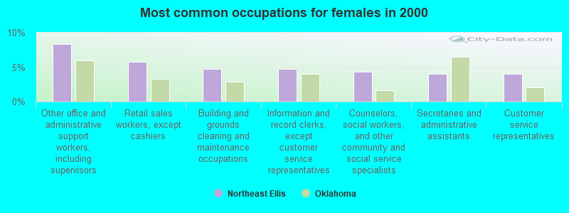
- Other office and administrative support workers, including supervisors (8.3%)
- Retail sales workers, except cashiers (5.8%)
- Building and grounds cleaning and maintenance occupations (4.7%)
- Information and record clerks, except customer service representatives (4.7%)
- Counselors, social workers, and other community and social service specialists (4.3%)
- Secretaries and administrative assistants (4.0%)
- Customer service representatives (4.0%)
Average climate in Northeast Ellis, Oklahoma
Based on data reported by over 4,000 weather stations


Tornado activity:
Northeast Ellis-area historical tornado activity is below Oklahoma state average. It is 61% greater than the overall U.S. average.
On 6/21/1958, a category F3 (max. wind speeds 158-206 mph) tornado 7.3 miles away from the Northeast Ellis place center caused between $50,000 and $500,000 in damages.
On 3/22/1987, a category F3 tornado 15.3 miles away from the place center caused between $50,000 and $500,000 in damages.
Earthquake activity:
Northeast Ellis-area historical earthquake activity is significantly above Oklahoma state average. It is 785% greater than the overall U.S. average.On 9/3/2016 at 12:02:44, a magnitude 5.8 (5.8 MW, Depth: 3.5 mi, Class: Moderate, Intensity: VI - VII) earthquake occurred 155.0 miles away from Northeast Ellis center
On 11/6/2011 at 03:53:10, a magnitude 5.7 (5.7 MW, Depth: 3.2 mi) earthquake occurred 175.7 miles away from Northeast Ellis center
On 2/13/2016 at 17:07:06, a magnitude 5.1 (5.1 MW, Depth: 5.2 mi) earthquake occurred 56.2 miles away from the city center
On 1/7/2016 at 04:27:57, a magnitude 4.7 (4.7 MW, Depth: 2.5 mi, Class: Light, Intensity: IV - V) earthquake occurred 55.3 miles away from the city center
On 11/19/2015 at 07:42:12, a magnitude 4.7 (4.7 MW, Depth: 3.7 mi) earthquake occurred 71.9 miles away from Northeast Ellis center
On 2/15/1974 at 13:33:49, a magnitude 4.6 (4.5 MB, 4.6 LG) earthquake occurred 54.9 miles away from Northeast Ellis center
Magnitude types: regional Lg-wave magnitude (LG), body-wave magnitude (MB), moment magnitude (MW)
Natural disasters:
The number of natural disasters in Ellis County (19) is greater than the US average (15).Major Disasters (Presidential) Declared: 11
Emergencies Declared: 6
Causes of natural disasters: Floods: 8, Winter Storms: 8, Storms: 7, Tornadoes: 5, Hurricane: 1, Ice Storm: 1, Snow: 1, Snowstorm: 1, Other: 1 (Note: some incidents may be assigned to more than one category).
Colleges/universities with over 2000 students nearest to Northeast Ellis:
- Southwestern Oklahoma State University (about 83 miles; Weatherford, OK; Full-time enrollment: 4,126)
- Western Oklahoma State College (about 122 miles; Altus, OK; FT enrollment: 2,054)
- Southern Nazarene University (about 132 miles; Bethany, OK; FT enrollment: 2,064)
- Oklahoma State University-Oklahoma City (about 136 miles; Oklahoma City, OK; FT enrollment: 4,784)
- University of Central Oklahoma (about 136 miles; Edmond, OK; FT enrollment: 13,790)
- Northern Oklahoma College (about 136 miles; Tonkawa, OK; FT enrollment: 3,414)
- Oklahoma City University (about 137 miles; Oklahoma City, OK; FT enrollment: 2,547)
Points of interest:
Notable locations in Northeast Ellis: Cattleman's Choice Feedyard (A), Gage Fire Department (B), Fargo Fire Department (C). Display/hide their locations on the map
Churches in Northeast Ellis include: First Christian Church (A), Greenwood Church (B), Mount Olive Church (C). Display/hide their locations on the map
Cemeteries: Fargo Cemetery (1), Gage Cemetery (2), Braunch Memorial Park (3), Mount Olive Cemetery (4), May Cemetery (5), Sunset Cemetery (6). Display/hide their locations on the map
Reservoirs: Oknoname 045001 Reservoir (A), Doersch Reservoir (B). Display/hide their locations on the map
Creeks: Boggy Creek (A), Twentyfive Mile Creek (B), Sixteenmile Creek (C), Buzzard Creek (D), Little Wolf Creek (E). Display/hide their locations on the map
Park in Northeast Ellis: Gage Artesian Beach (1). Display/hide its location on the map
| This place: | 2.4 people |
| Oklahoma: | 2.5 people |
| This place: | 66.5% |
| Whole state: | 66.8% |
| This place: | 4.8% |
| Whole state: | 5.9% |
Likely homosexual households (counted as self-reported same-sex unmarried-partner households)
- Lesbian couples: 0.0% of all households
- Gay men: 0.6% of all households
| This place: | 16.3% |
| Whole state: | 14.7% |
| This place: | 6.0% |
| Whole state: | 6.1% |
For population 15 years and over in Northeast Ellis:
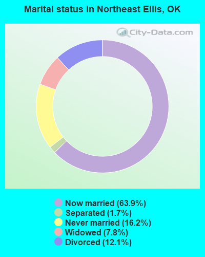
- Never married: 16.2%
- Now married: 63.9%
- Separated: 1.7%
- Widowed: 7.8%
- Divorced: 12.1%
For population 25 years and over in Northeast Ellis:
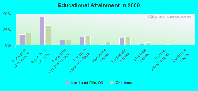
- High school or higher: 82.6%
- Bachelor's degree or higher: 14.4%
- Graduate or professional degree: 2.7%
- Unemployed: 3.1%
- Mean travel time to work (commute): 19.3 minutes
| Here: | 8.9 |
| Oklahoma average: | 11.7 |
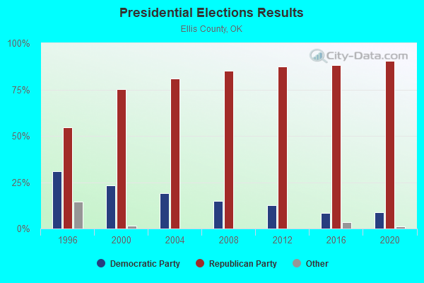
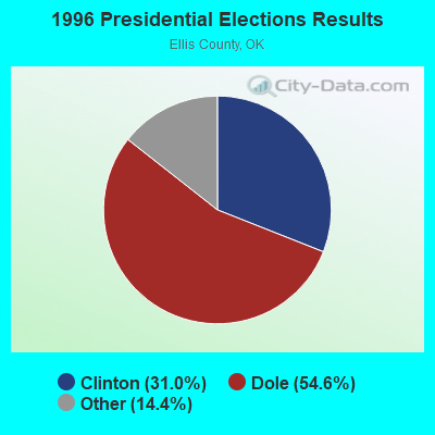
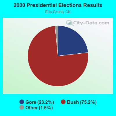
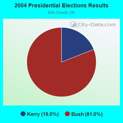
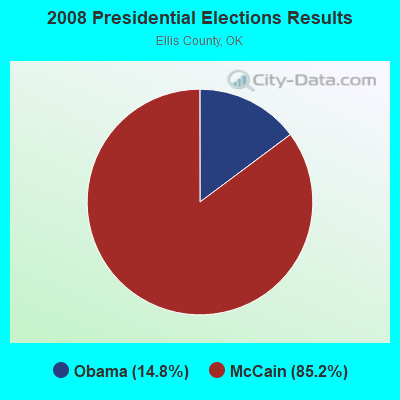
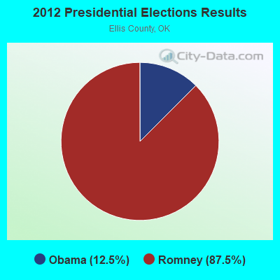
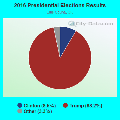
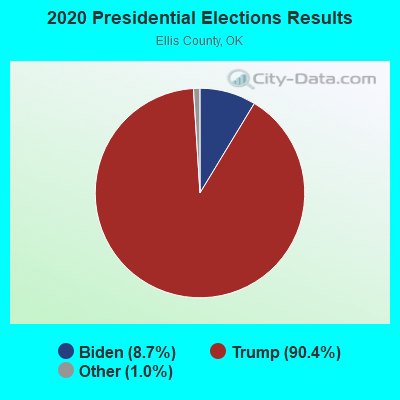
Graphs represent county-level data. Detailed 2008 Election Results
Religion statistics for Northeast Ellis, OK (based on Ellis County data)
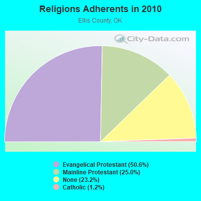
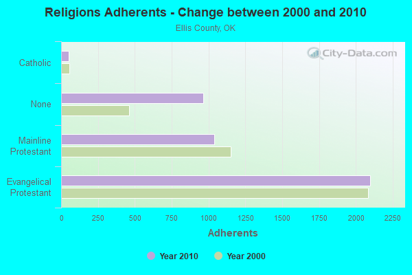
| Religion | Adherents | Congregations |
|---|---|---|
| Evangelical Protestant | 2,099 | 17 |
| Mainline Protestant | 1,037 | 6 |
| Catholic | 50 | 1 |
| None | 965 | - |
Food Environment Statistics:
| Here: | 7.71 / 10,000 pop. |
| Oklahoma: | 1.97 / 10,000 pop. |
| Ellis County: | 5.14 / 10,000 pop. |
| Oklahoma: | 0.76 / 10,000 pop. |
| Ellis County: | 7.71 / 10,000 pop. |
| Oklahoma: | 4.35 / 10,000 pop. |
| Ellis County: | 12.84 / 10,000 pop. |
| Oklahoma: | 6.89 / 10,000 pop. |
| Here: | 11.5% |
| Oklahoma: | 10.3% |
| Ellis County: | 29.9% |
| State: | 29.2% |
Strongest AM radio stations in Northeast Ellis:
- KGYN (1210 AM; 50 kW; GUYMON, OK; Owner: TELNS BROADCASTING COMPANY, INC.)
- KSIW (1450 AM; 1 kW; WOODWARD, OK; Owner: FUCHS COMMUNICATIONS, INC.)
- KRMG (740 AM; 50 kW; TULSA, OK; Owner: CXR HOLDINGS, INC.)
- KOMA (1520 AM; 50 kW; OKLAHOMA CITY, OK; Owner: RENDA BROADCASTING CORP. OF NEVADA)
- KFAQ (1170 AM; 50 kW; TULSA, OK; Owner: JOURNAL BROADCAST CORPORATION)
- KGNC (710 AM; 10 kW; AMARILLO, TX; Owner: MCC RADIO, LLC)
- KICA (980 AM; 50 kW; CLOVIS, NM; Owner: BROADCAST ENTERTAINMENT CORPORATION)
- KCRC (1390 AM; 10 kW; ENID, OK; Owner: CHISHOLM TRAIL BROADCASTING CO.)
- KRVN (880 AM; 50 kW; LEXINGTON, NE; Owner: NEBRASKA RURAL RADIO ASSOCIATION)
- WBAP (820 AM; 50 kW; FORT WORTH, TX; Owner: WBAP-KSCS OPERATING, LTD.)
- KMUL (1380 AM; 50 kW; MULESHOE, TX; Owner: BROADCAST ENTERTAINMENT CORPORATION)
- KSCB (1270 AM; 5 kW; LIBERAL, KS; Owner: SEWARD COUNTY BROADCASTING CO., INC.)
- KLTT (670 AM; 50 kW; COMMERCE CITY, CO; Owner: KLZ RADIO, INC.)
Strongest FM radio stations in Northeast Ellis:
- KWFX (93.5 FM; WOODWARD, OK; Owner: CLASSIC COMMUNICATIONS INC)
- KWOX (101.1 FM; WOODWARD, OK; Owner: OMNI COMMUNICATIONS, INC.)
- KMZE (92.1 FM; WOODWARD, OK; Owner: FM 92 BROADCASTERS, INC.)
- KWDQ (102.3 FM; WOODWARD, OK; Owner: CLASSIC COMMUNICATIONS, INC.)
- KJOV (90.7 FM; WOODWARD, OK; Owner: GREAT PLAINS CHRISTIAN RADIO. INC.)
- K210BQ (89.9 FM; WOODWARD, OK; Owner: GREAT PLAINS CHRISTIAN RADIO, INC.)
- K204EQ (88.7 FM; WOODWARD, OK; Owner: CALVARY CHAPEL OF TWIN FALLS, INC.)
- K300AH (107.9 FM; WOODWARD, OK; Owner: FLORIDA PUBLIC RADIO, INC.)
- KAZY (95.9 FM; WOODWARD, OK; Owner: SHAFFER COMMUNICATIONS GROUP)
TV broadcast stations around Northeast Ellis:
- K18BV (Channel 18; MAY, ETC., OK; Owner: SHAFER TRANSLATOR, INC.)
- K20BR (Channel 20; GAGE, ETC., OK; Owner: SHAFER TRANSLATOR, INC.)
- K22BR (Channel 22; MAY, ETC., OK; Owner: SHAFER TRANSLATOR, INC.)
- K16DX (Channel 16; GAGE, OK; Owner: SHAFER TRANSLATOR INC.)
- KOMI-LP (Channel 24; WOODWARD, OK; Owner: 101 TELEVISION)
- 56.2%Utility gas
- 21.9%Bottled, tank, or LP gas
- 17.6%Electricity
- 3.3%Wood
- 1.0%Other fuel

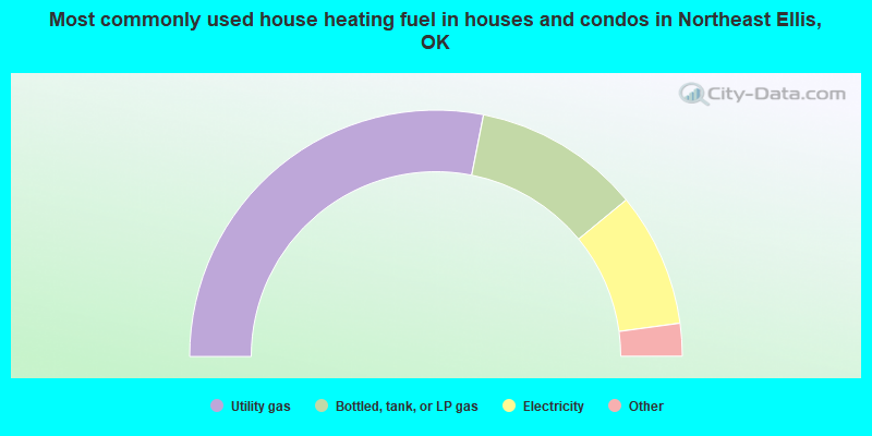
- 59.1%Utility gas
- 20.9%Bottled, tank, or LP gas
- 20.0%Electricity
Northeast Ellis compared to Oklahoma state average:
- Median house value below state average.
- Unemployed percentage significantly below state average.
- Black race population percentage significantly below state average.
- Hispanic race population percentage significantly below state average.
- Median age above state average.
- Foreign-born population percentage significantly below state average.
- Length of stay since moving in significantly above state average.
- Number of rooms per house significantly below state average.
- House age significantly below state average.
- Number of college students significantly below state average.