North McCurtain, Oklahoma
Submit your own pictures of this place and show them to the world
- OSM Map
- General Map
- Google Map
- MSN Map

| Males: 1,479 | |
| Females: 1,443 |
| Median resident age: | 37.1 years |
| Oklahoma median age: | 35.5 years |
Zip code: 74728
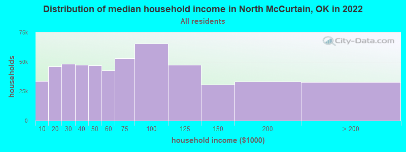
| North McCurtain: | $42,396 |
| OK: | $59,673 |
Estimated per capita income in 2022: $20,793 (it was $11,803 in 2000)
North McCurtain CCD income, earnings, and wages data
Estimated median house or condo value in 2022: $123,600 (it was $44,900 in 2000)
| North McCurtain: | $123,600 |
| OK: | $191,700 |
Mean prices in 2022: all housing units: $164,293; detached houses: $180,472; townhouses or other attached units: $117,597; mobile homes: $56,718; occupied boats, rvs, vans, etc.: $8,076
North McCurtain, OK residents, houses, and apartments details
Detailed information about poverty and poor residents in North McCurtain, OK


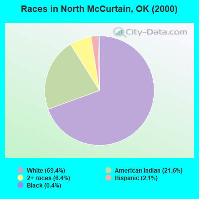
- 2,08569.4%White alone
- 65021.6%American Indian alone
- 1936.4%Two or more races
- 632.1%Hispanic
- 110.4%Black alone
- 10.03%Asian alone
Races in North McCurtain detailed stats: ancestries, foreign born residents, place of birth
 Recent articles from our blog. Our writers, many of them Ph.D. graduates or candidates, create easy-to-read articles on a wide variety of topics.
Current Local Time: CST time zone
Land area: 687.1 square miles.
Population density: 4.3 people per square mile (very low).

| North McCurtain CCD: | 0.4% ($199) |
| Oklahoma: | 0.8% ($523) |
Nearest city with pop. 50,000+: Fort Smith, AR  (73.5 miles , pop. 80,268).
Nearest city with pop. 200,000+: Tulsa, OK (140.7 miles , pop. 393,049).
Nearest city with pop. 1,000,000+: Dallas, TX (158.9 miles , pop. 1,188,580).
Nearest cities:
), ), ), Latitude: 34.34 N, Longitude: 94.75 W

| Here: | 4.5% |
| Oklahoma: | 3.2% |
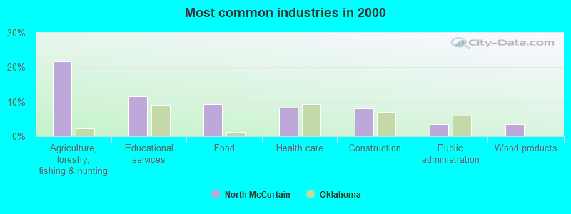
- Agriculture, forestry, fishing & hunting (21.7%)
- Educational services (11.5%)
- Food (9.3%)
- Health care (8.2%)
- Construction (8.0%)
- Public administration (3.6%)
- Wood products (3.4%)
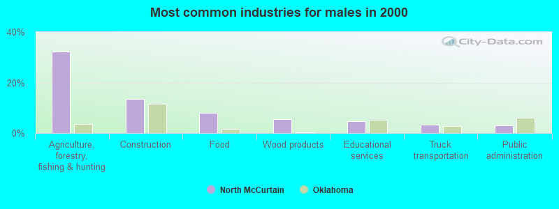
- Agriculture, forestry, fishing & hunting (32.2%)
- Construction (13.6%)
- Food (8.0%)
- Wood products (5.4%)
- Educational services (4.7%)
- Truck transportation (3.3%)
- Public administration (2.9%)
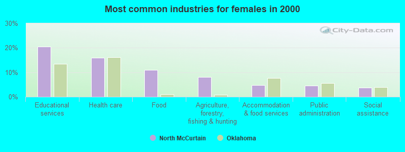
- Educational services (20.5%)
- Health care (15.9%)
- Food (11.0%)
- Agriculture, forestry, fishing & hunting (8.0%)
- Accommodation & food services (4.7%)
- Public administration (4.5%)
- Social assistance (3.7%)
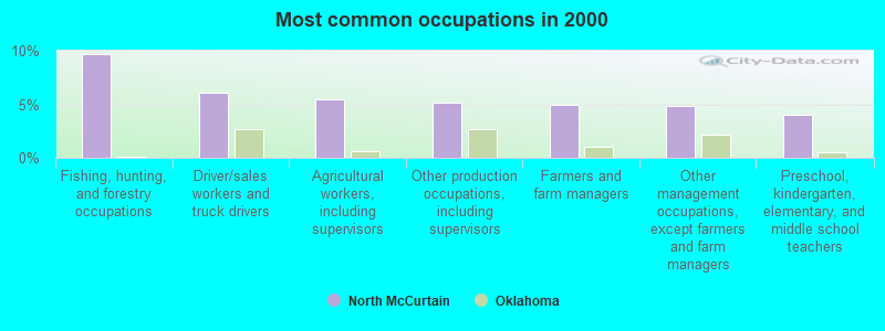
- Fishing, hunting, and forestry occupations (9.7%)
- Driver/sales workers and truck drivers (6.0%)
- Agricultural workers, including supervisors (5.5%)
- Other production occupations, including supervisors (5.2%)
- Farmers and farm managers (4.9%)
- Other management occupations, except farmers and farm managers (4.8%)
- Preschool, kindergarten, elementary, and middle school teachers (4.0%)
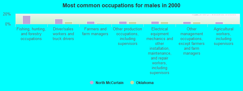
- Fishing, hunting, and forestry occupations (17.0%)
- Driver/sales workers and truck drivers (10.1%)
- Farmers and farm managers (5.4%)
- Other production occupations, including supervisors (5.4%)
- Electrical equipment mechanics and other installation, maintenance, and repair workers, including supervisors (5.2%)
- Other management occupations, except farmers and farm managers (5.1%)
- Agricultural workers, including supervisors (4.2%)
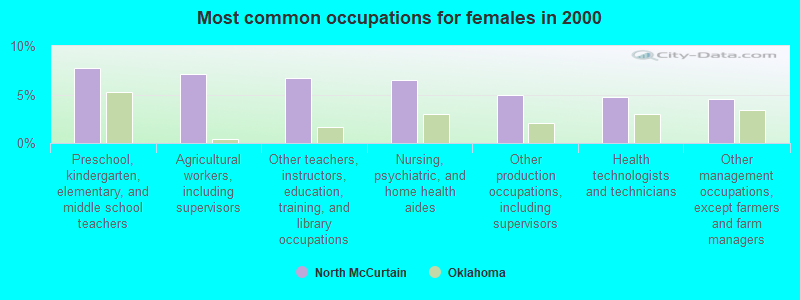
- Preschool, kindergarten, elementary, and middle school teachers (7.8%)
- Agricultural workers, including supervisors (7.1%)
- Other teachers, instructors, education, training, and library occupations (6.7%)
- Nursing, psychiatric, and home health aides (6.5%)
- Other production occupations, including supervisors (5.0%)
- Health technologists and technicians (4.7%)
- Other management occupations, except farmers and farm managers (4.5%)
Average climate in North McCurtain, Oklahoma
Based on data reported by over 4,000 weather stations


Tornado activity:
North McCurtain-area historical tornado activity is below Oklahoma state average. It is 59% greater than the overall U.S. average.
On 4/2/1982, a category F5 (max. wind speeds 261-318 mph) tornado 25.8 miles away from the North McCurtain place center injured 29 people and caused between $500,000 and $5,000,000 in damages.
On 5/5/1961, a category F4 (max. wind speeds 207-260 mph) tornado 31.2 miles away from the place center killed 16 people and injured 58 people and caused between $50,000 and $500,000 in damages.
Earthquake activity:
North McCurtain-area historical earthquake activity is significantly above Oklahoma state average. It is 572% greater than the overall U.S. average.On 11/6/2011 at 03:53:10, a magnitude 5.7 (5.7 MW, Depth: 3.2 mi, Class: Moderate, Intensity: VI - VII) earthquake occurred 140.9 miles away from North McCurtain center
On 9/3/2016 at 12:02:44, a magnitude 5.8 (5.8 MW, Depth: 3.5 mi) earthquake occurred 189.4 miles away from the city center
On 11/7/2016 at 01:44:24, a magnitude 5.0 (5.0 MW, Depth: 2.8 mi) earthquake occurred 162.8 miles away from the city center
On 11/5/2011 at 07:12:45, a magnitude 4.8 (4.8 MW, Depth: 1.9 mi, Class: Light, Intensity: IV - V) earthquake occurred 141.6 miles away from North McCurtain center
On 11/8/2011 at 02:46:57, a magnitude 4.8 (4.8 MW, Depth: 3.1 mi) earthquake occurred 141.9 miles away from the city center
On 9/6/1997 at 23:38:00, a magnitude 4.5 (4.5 LG, 4.2 LG, Depth: 3.1 mi) earthquake occurred 98.7 miles away from North McCurtain center
Magnitude types: regional Lg-wave magnitude (LG), moment magnitude (MW)
Natural disasters:
The number of natural disasters in McCurtain County (16) is near the US average (15).Major Disasters (Presidential) Declared: 10
Emergencies Declared: 5
Causes of natural disasters: Floods: 7, Storms: 7, Winter Storms: 7, Tornadoes: 4, Hurricane: 1, Snow: 1, Wind: 1, Other: 1 (Note: some incidents may be assigned to more than one category).
Colleges/universities with over 2000 students nearest to North McCurtain:
- Carl Albert State College (about 49 miles; Poteau, OK; Full-time enrollment: 2,041)
- Paris Junior College (about 66 miles; Paris, TX; FT enrollment: 3,875)
- Texarkana College (about 74 miles; Texarkana, TX; FT enrollment: 2,629)
- University of Arkansas-Fort Smith (about 76 miles; Fort Smith, AR; FT enrollment: 6,103)
- Northeast Texas Community College (about 87 miles; Mount Pleasant, TX; FT enrollment: 2,320)
- National Park Community College (about 94 miles; Hot Springs, AR; FT enrollment: 2,237)
- Southeastern Oklahoma State University (about 97 miles; Durant, OK; FT enrollment: 3,365)
Points of interest:
Notable locations in North McCurtain: Watson Community Fire Department (A), Bethel Volunteer Fire Fighters Association (B), Pickens Volunteer Fire Department (C), Hochatown Volunteer Fire Department (D), Battiest Volunteer Fire Department (E), Sherwood Volunteer Fire Department (F), Octavia - Smithville Rural Fire Association Station 2 (G). Display/hide their locations on the map
Churches in North McCurtain include: Bethel Hill Church (A), Countyline Church (B), Indian Mission (C), Panther Creek Church (D), Kulli-Chito Presbyterian Church (E), Cumberland Church (F), Silver Creek Church (G), Mount Zion Church (H). Display/hide their locations on the map
Cemeteries: Parsons Cemetery (1), Watson Cemetery (2), Beechtree Cemetery (3), Sherwood Cemetery (4), Hochatown Cemetery (5), Bethel Cemetery (6), Smithville Cemetery (7). Display/hide their locations on the map
Lakes and reservoirs: Calahan Lake (A), Henderson Lake (B), Broken Bow Lake (C), Oknoname 089008 Reservoir (D). Display/hide their locations on the map
Streams, rivers, and creeks: Burke Branch (A), Bull Creek (B), Holly Creek (C), Buffalo Creek (D), Buck Creek (E), West Fork Glover River (F), Brigham Young Branch (G), Watson Branch (H), Boktuklo Creek (I). Display/hide their locations on the map
Parks in North McCurtain include: Stephens Gap Recreation Area (1), Carson Creek Recreation Area (2), Cedar Creek Recreation Area (3), Hochatown State Park (4), McCurtain County Game Reserve (5). Display/hide their locations on the map
| This place: | 2.5 people |
| Oklahoma: | 2.5 people |
| This place: | 71.3% |
| Whole state: | 66.8% |
| This place: | 4.3% |
| Whole state: | 5.9% |
Likely homosexual households (counted as self-reported same-sex unmarried-partner households)
- Lesbian couples: 0.2% of all households
- Gay men: 0.2% of all households
| This place: | 26.2% |
| Whole state: | 14.7% |
| This place: | 8.2% |
| Whole state: | 6.1% |
For population 15 years and over in North McCurtain:
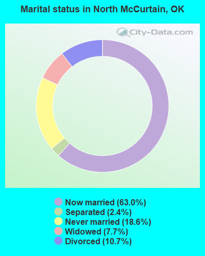
- Never married: 18.6%
- Now married: 63.0%
- Separated: 2.4%
- Widowed: 7.7%
- Divorced: 10.7%
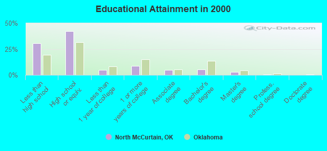
For population 25 years and over in North McCurtain:
- High school or higher: 69.3%
- Bachelor's degree or higher: 8.5%
- Graduate or professional degree: 3.3%
- Unemployed: 6.1%
- Mean travel time to work (commute): 36.9 minutes
| Here: | 12.6 |
| Oklahoma average: | 11.7 |
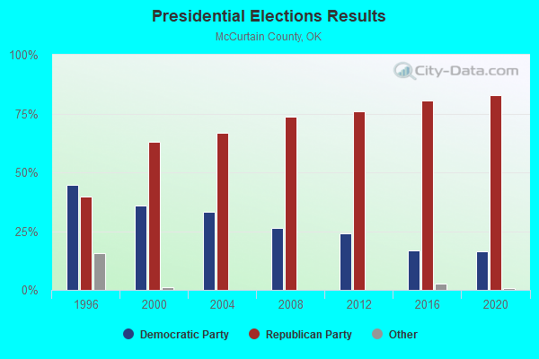
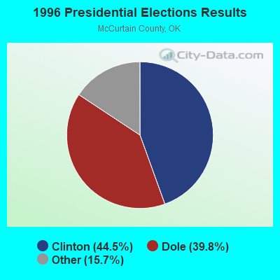
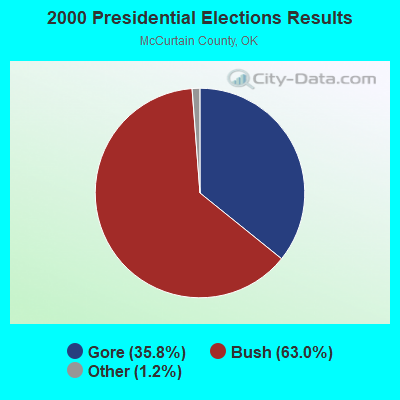
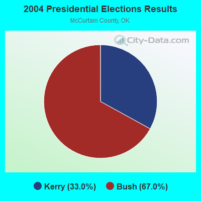

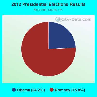
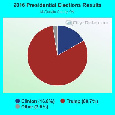
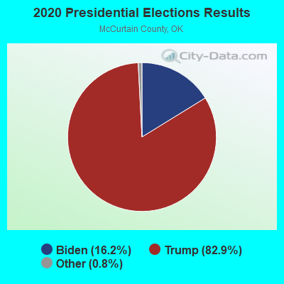
Graphs represent county-level data. Detailed 2008 Election Results
Religion statistics for North McCurtain, OK (based on McCurtain County data)
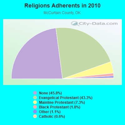
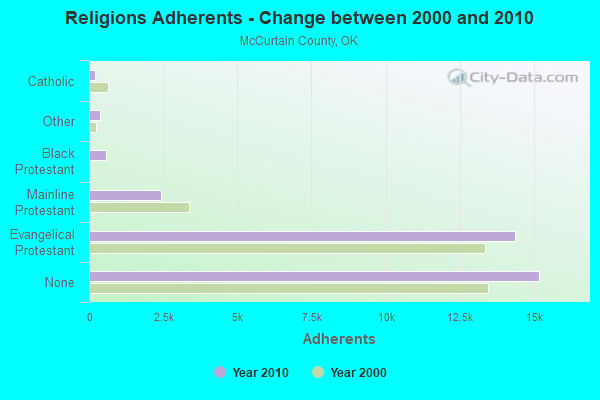
| Religion | Adherents | Congregations |
|---|---|---|
| Evangelical Protestant | 14,352 | 94 |
| Mainline Protestant | 2,422 | 31 |
| Black Protestant | 589 | 4 |
| Other | 381 | 5 |
| Catholic | 215 | 1 |
| None | 15,192 | - |
Food Environment Statistics:
| Here: | 3.29 / 10,000 pop. |
| Oklahoma: | 1.97 / 10,000 pop. |
| Here: | 0.30 / 10,000 pop. |
| Oklahoma: | 0.76 / 10,000 pop. |
| Here: | 7.78 / 10,000 pop. |
| Oklahoma: | 4.35 / 10,000 pop. |
| This county: | 3.59 / 10,000 pop. |
| Oklahoma: | 6.89 / 10,000 pop. |
| McCurtain County: | 10.5% |
| Oklahoma: | 10.3% |
| This county: | 31.0% |
| Oklahoma: | 29.2% |
Strongest AM radio stations in North McCurtain:
- KEEL (710 AM; 50 kW; SHREVEPORT, LA; Owner: CITICASTERS LICENSES, L.P.)
- KRMG (740 AM; 50 kW; TULSA, OK; Owner: CXR HOLDINGS, INC.)
- KWKH (1130 AM; 50 kW; SHREVEPORT, LA; Owner: CITICASTERS LICENSES, L.P.)
- KGHT (880 AM; 50 kW; SHERIDAN, AR; Owner: METROPOLITAN RADIO GROUP, INC.)
- KFAQ (1170 AM; 50 kW; TULSA, OK; Owner: JOURNAL BROADCAST CORPORATION)
- KFXR (1190 AM; 50 kW; DALLAS, TX; Owner: CLEAR CHANNEL BROADCASTING LICENSES, INC.)
- KAAY (1090 AM; 50 kW; LITTLE ROCK, AR; Owner: CITADEL BROADCASTING COMPANY)
- KRLD (1080 AM; 50 kW; DALLAS, TX; Owner: TEXAS INFINITY BROADCASTING L.P.)
- WBAP (820 AM; 50 kW; FORT WORTH, TX; Owner: WBAP-KSCS OPERATING, LTD.)
- KWXI (670 AM; daytime; 5 kW; GLENWOOD, AR; Owner: PGR COMMUNICATIONS, INC.)
- KYHN (1320 AM; 10 kW; FORT SMITH, AR; Owner: CAPSTAR TX LIMITED PARTNERSHIP)
- KPYN (900 AM; 10 kW; ATLANTA, TX; Owner: FAMILY WORSHIP CENTER CHURCH, INC.)
- KESS (1270 AM; 50 kW; FORT WORTH, TX; Owner: KESS-AM LICENSE CORP.)
Strongest FM radio stations in North McCurtain:
- KKBI (106.1 FM; BROKEN BOW, OK; Owner: J.D.C. RADIO, INC.)
- KZBB (97.9 FM; POTEAU, OK; Owner: CAPSTAR TX LIMITED PARTNERSHIP)
- KMAG (99.1 FM; FORT SMITH, AR; Owner: CAPSTAR TX LIMITED PARTNERSHIP)
- KOMS (107.3 FM; POTEAU, OK; Owner: CUMULUS LICENSING CORP.)
- KTCS-FM (99.9 FM; FORT SMITH, AR; Owner: BIG CHIEF BROADCASTING COMPANY)
- K204EW (88.7 FM; POTEAU, OK; Owner: CALVARY CHAPEL OF TWIN FALLS, INC.)
- K219CN (91.7 FM; POTEAU, OK; Owner: AMERICAN FAMILY ASSOCIATION)
- KARG (91.7 FM; POTEAU, OK; Owner: AMERICAN FAMILY ASSOCIATION)
- KQOR (105.3 FM; MENA, AR; Owner: OUACHITA BROADCASTING, INC.)
- KDQN-FM (92.1 FM; DE QUEEN, AR; Owner: JAY W. BUNYARD & ANNE W. BUNYARD)
TV broadcast stations around North McCurtain:
- K28DJ (Channel 28; BROKEN BOW, OK; Owner: TRUSTEES OF J.B.CALLAHAM R.T.)
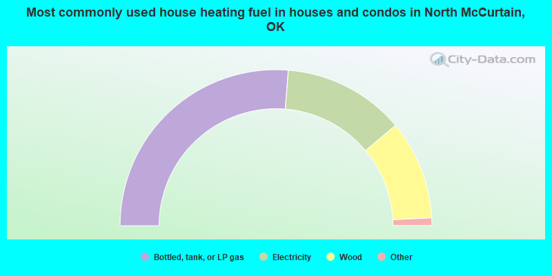
- 52.5%Bottled, tank, or LP gas
- 25.2%Electricity
- 20.6%Wood
- 0.9%Utility gas
- 0.5%No fuel used
- 0.2%Other fuel
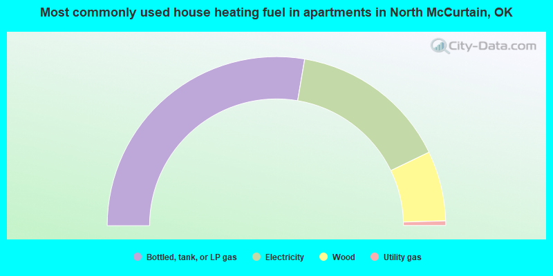
- 55.4%Bottled, tank, or LP gas
- 30.4%Electricity
- 13.4%Wood
- 0.9%Utility gas
North McCurtain compared to Oklahoma state average:
- Median house value below state average.
- Unemployed percentage below state average.
- Black race population percentage significantly below state average.
- Hispanic race population percentage significantly below state average.
- Foreign-born population percentage significantly below state average.
- Renting percentage below state average.
- Length of stay since moving in significantly above state average.
- Number of rooms per house significantly below state average.
- House age significantly below state average.
- Number of college students below state average.
- Percentage of population with a bachelor's degree or higher below state average.