North Jim Hogg, Texas
Submit your own pictures of this place and show them to the world
- OSM Map
- General Map
- Google Map
- MSN Map

| Males: 2,332 | |
| Females: 2,427 |
| Median resident age: | 33.7 years |
| Texas median age: | 32.3 years |
Zip code: 78361
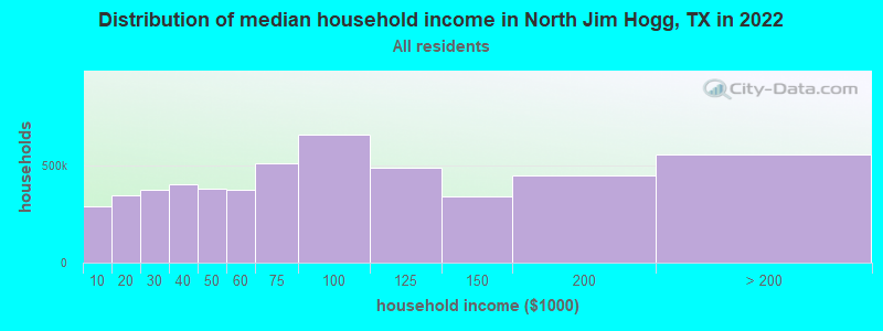
| North Jim Hogg: | $42,128 |
| TX: | $72,284 |
Estimated per capita income in 2022: $18,736 (it was $12,232 in 2000)
North Jim Hogg CCD income, earnings, and wages data
Estimated median house or condo value in 2022: $132,380 (it was $32,800 in 2000)
| North Jim Hogg: | $132,380 |
| TX: | $275,400 |
Mean prices in 2022: all housing units: $137,503; detached houses: $127,387; townhouses or other attached units: $77,985; mobile homes: $202,204
North Jim Hogg, TX residents, houses, and apartments details
Detailed information about poverty and poor residents in North Jim Hogg, TX


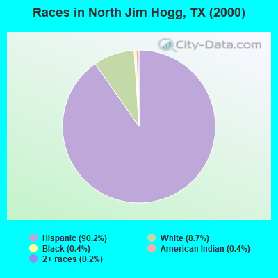
- 4,61790.2%Hispanic
- 4458.7%White alone
- 220.4%Black alone
- 190.4%American Indian alone
- 90.2%Two or more races
- 50.10%Asian alone
Races in North Jim Hogg detailed stats: ancestries, foreign born residents, place of birth
 Recent articles from our blog. Our writers, many of them Ph.D. graduates or candidates, create easy-to-read articles on a wide variety of topics.
Current Local Time: CST time zone
Land area: 338.4 square miles.
Population density: 14 people per square mile (very low).

| North Jim Hogg CCD: | 1.3% ($426) |
| Texas: | 1.8% ($1,393) |
Nearest city with pop. 50,000+: Laredo, TX  (51.2 miles , pop. 176,576).
Nearest city with pop. 200,000+: Corpus Christi, TX (86.2 miles , pop. 277,454).
Nearest city with pop. 1,000,000+: San Antonio, TX (150.9 miles , pop. 1,144,646).
Nearest cities:
), ), ), ), ), )Latitude: 27.28 N, Longitude: 98.71 W
Area code commonly used in this area: 361

| Here: | 4.2% |
| Texas: | 3.5% |
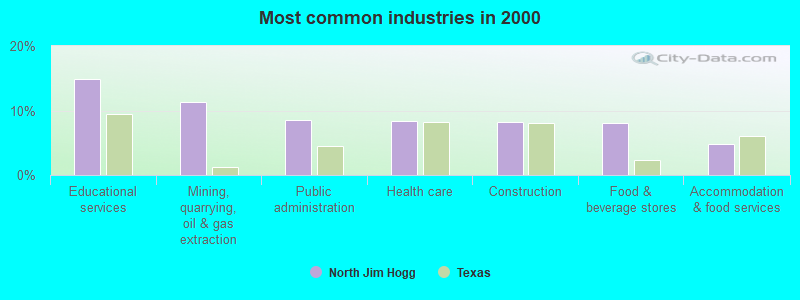
- Educational services (14.9%)
- Mining, quarrying, oil & gas extraction (11.3%)
- Public administration (8.6%)
- Health care (8.4%)
- Construction (8.1%)
- Food & beverage stores (8.0%)
- Accommodation & food services (4.7%)
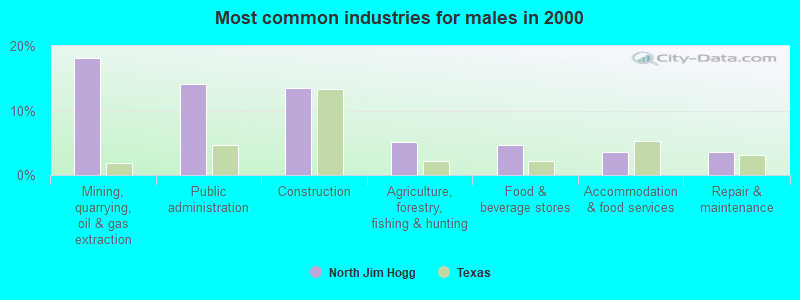
- Mining, quarrying, oil & gas extraction (18.1%)
- Public administration (14.1%)
- Construction (13.5%)
- Agriculture, forestry, fishing & hunting (5.2%)
- Food & beverage stores (4.7%)
- Accommodation & food services (3.6%)
- Repair & maintenance (3.5%)
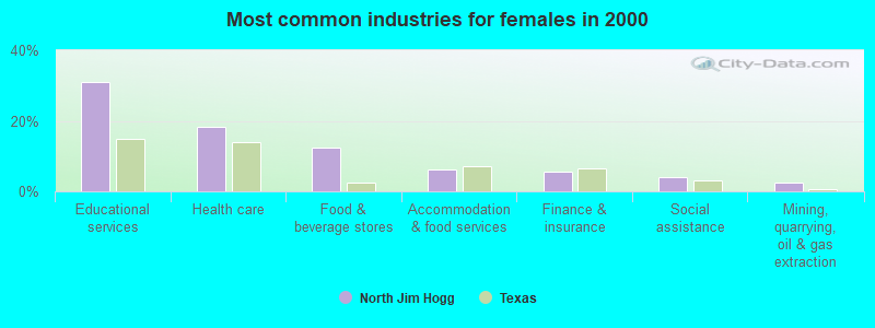
- Educational services (31.1%)
- Health care (18.2%)
- Food & beverage stores (12.4%)
- Accommodation & food services (6.2%)
- Finance & insurance (5.7%)
- Social assistance (4.1%)
- Mining, quarrying, oil & gas extraction (2.6%)
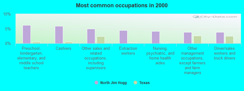
- Preschool, kindergarten, elementary, and middle school teachers (6.1%)
- Cashiers (5.8%)
- Other sales and related occupations, including supervisors (5.0%)
- Extraction workers (4.5%)
- Nursing, psychiatric, and home health aides (4.2%)
- Other management occupations, except farmers and farm managers (3.8%)
- Driver/sales workers and truck drivers (3.8%)
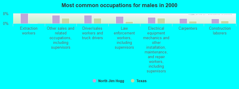
- Extraction workers (7.9%)
- Other sales and related occupations, including supervisors (6.9%)
- Driver/sales workers and truck drivers (6.8%)
- Law enforcement workers, including supervisors (5.7%)
- Electrical equipment mechanics and other installation, maintenance, and repair workers, including supervisors (5.1%)
- Carpenters (4.2%)
- Construction laborers (3.9%)
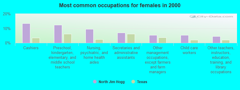
- Cashiers (13.4%)
- Preschool, kindergarten, elementary, and middle school teachers (12.4%)
- Nursing, psychiatric, and home health aides (9.5%)
- Secretaries and administrative assistants (7.1%)
- Other management occupations, except farmers and farm managers (5.4%)
- Child care workers (5.3%)
- Other teachers, instructors, education, training, and library occupations (4.5%)
Average climate in North Jim Hogg, Texas
Based on data reported by over 4,000 weather stations


Tornado activity:
North Jim Hogg-area historical tornado activity is significantly below Texas state average. It is 71% smaller than the overall U.S. average.
On 6/29/1971, a category F2 (max. wind speeds 113-157 mph) tornado 20.7 miles away from the North Jim Hogg place center caused between $5000 and $50,000 in damages.
On 4/19/1965, a category F3 (max. wind speeds 158-206 mph) tornado 46.1 miles away from the place center .
Earthquake activity:
North Jim Hogg-area historical earthquake activity is significantly above Texas state average. It is 47% smaller than the overall U.S. average.On 10/20/2011 at 12:24:41, a magnitude 4.8 (4.8 MW, Depth: 3.1 mi, Class: Light, Intensity: IV - V) earthquake occurred 116.4 miles away from the city center
On 4/14/1995 at 00:32:56, a magnitude 5.7 (5.6 MB, 5.7 MS, 5.7 MW, Depth: 11.1 mi, Class: Moderate, Intensity: VI - VII) earthquake occurred 350.7 miles away from North Jim Hogg center
On 4/9/1993 at 12:29:19, a magnitude 4.3 (4.1 MB, 4.3 LG, Depth: 3.1 mi) earthquake occurred 112.0 miles away from the city center
On 4/25/2010 at 02:10:42, a magnitude 3.9 (3.9 MB, Depth: 3.1 mi, Class: Light, Intensity: II - III) earthquake occurred 60.7 miles away from the city center
On 3/24/1997 at 22:31:34, a magnitude 3.8 (3.8 LG, Depth: 3.1 mi) earthquake occurred 50.3 miles away from North Jim Hogg center
On 5/1/2018 at 16:28:56, a magnitude 4.0 (4.0 MW, Depth: 3.1 mi) earthquake occurred 123.3 miles away from the city center
Magnitude types: regional Lg-wave magnitude (LG), body-wave magnitude (MB), surface-wave magnitude (MS), moment magnitude (MW)
Natural disasters:
The number of natural disasters in Jim Hogg County (16) is near the US average (15).Major Disasters (Presidential) Declared: 8
Emergencies Declared: 6
Causes of natural disasters: Hurricanes: 10, Fires: 2, Floods: 2, Heavy Rain: 1, Storm: 1, Tornado: 1, Tropical Storm: 1, Wind: 1, Other: 1 (Note: some incidents may be assigned to more than one category).
Colleges/universities with over 2000 students nearest to North Jim Hogg:
- Texas A & M International University (about 50 miles; Laredo, TX; Full-time enrollment: 5,203)
- Laredo Community College (about 53 miles; Laredo, TX; FT enrollment: 9,743)
- Texas A & M University-Kingsville (about 54 miles; Kingsville, TX; FT enrollment: 9,295)
- The University of Texas-Pan American (about 75 miles; Edinburg, TX; FT enrollment: 16,766)
- South Texas College (about 79 miles; McAllen, TX; FT enrollment: 19,701)
- Del Mar College (about 87 miles; Corpus Christi, TX; FT enrollment: 5,213)
- Texas A & M University-Corpus Christi (about 90 miles; Corpus Christi, TX; FT enrollment: 9,092)
Points of interest:
Notable locations in North Jim Hogg: Dusty Downs Racetrack (A), Chapote Windmill (B), Conejos Windmill (C), Georgies Windmill (D), Liebre Windmill (E), Martinez Windmill (F), Me Campbell Ranch (G), Nuevo Windmill (H), Pefina Windmill (I), Retama Windmill (J), Agua Negra Windmill (K), Armstrong Ranch (L), Azucar Windmill (M), Balderas Altas Windmill (N), Balderas Windmill (O), Buenos Aires Windmill (P), Camino de Fierro Windmill Number 1 (Q), Camino de Fierro Windmill Number 2 (R), Catoroe Windmill (S), Chili Pitien Windmill (T). Display/hide their locations on the map
Churches in North Jim Hogg include: Saint James Episcopal Church (A), Catholic Church (B), First Baptist Church (C), Hebbronville Assembly of God Church (D). Display/hide their locations on the map
Cemeteries: New Hebbronville Cemetery (1), Greenhill Cemetery (2), Old Hebbronville Cemetery (3). Display/hide their locations on the map
Creeks: Mesquite Creek (A), Noriacitas Creek (B). Display/hide their locations on the map
Park in North Jim Hogg: Gruy Stadium (1). Display/hide its location on the map
| This place: | 2.8 people |
| Texas: | 2.8 people |
| This place: | 72.6% |
| Whole state: | 69.9% |
| This place: | 6.0% |
| Whole state: | 6.0% |
Likely homosexual households (counted as self-reported same-sex unmarried-partner households)
- Lesbian couples: 0.5% of all households
- Gay men: 0.1% of all households
| This place: | 25.2% |
| Whole state: | 15.4% |
| This place: | 9.2% |
| Whole state: | 6.7% |
34 people in nursing homes in 2000
2 people in local jails and other confinement facilities (including police lockups) in 2000
For population 15 years and over in North Jim Hogg:
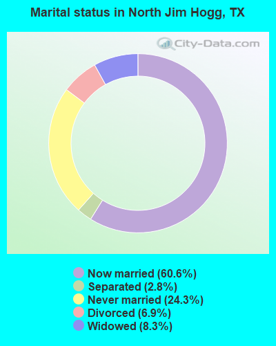
- Never married: 24.3%
- Now married: 60.6%
- Separated: 2.8%
- Widowed: 8.3%
- Divorced: 6.9%
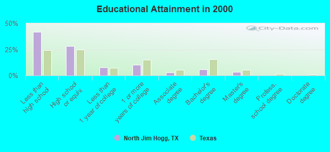
For population 25 years and over in North Jim Hogg:
- High school or higher: 58.4%
- Bachelor's degree or higher: 9.4%
- Graduate or professional degree: 3.4%
- Unemployed: 8.2%
- Mean travel time to work (commute): 22.9 minutes

| Here: | 23.5 |
| Texas average: | 15.6 |
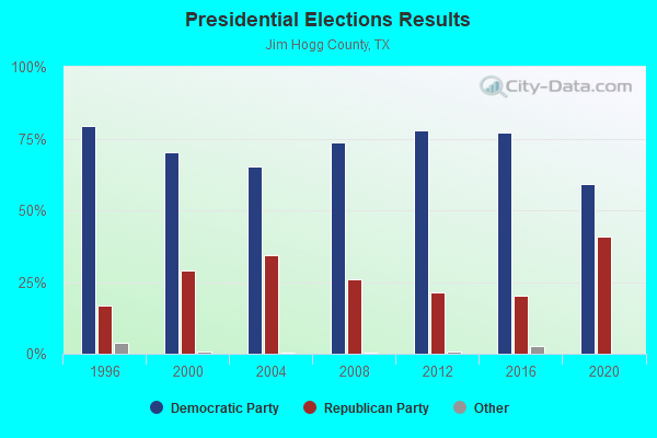
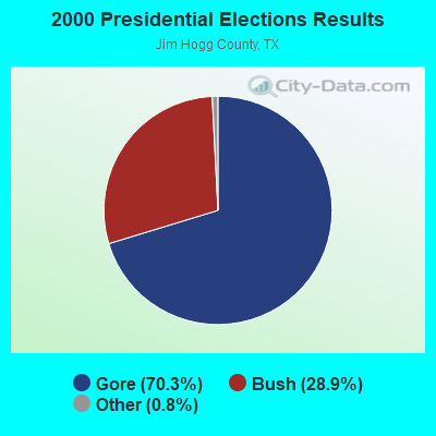
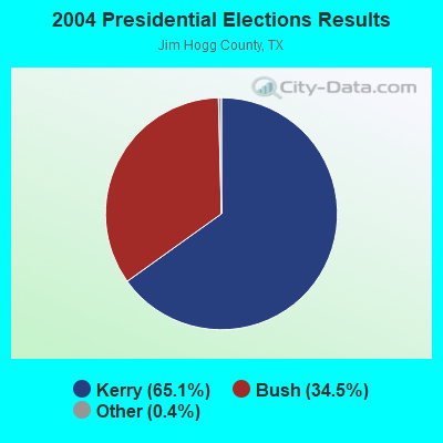
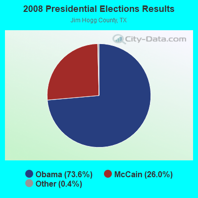
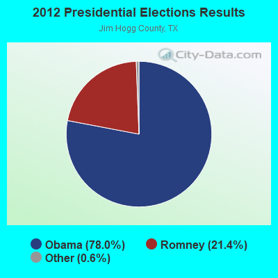
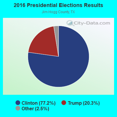
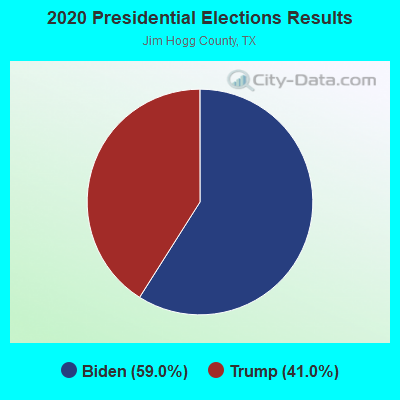
Graphs represent county-level data. Detailed 2008 Election Results
Religion statistics for North Jim Hogg, TX (based on Jim Hogg County data)
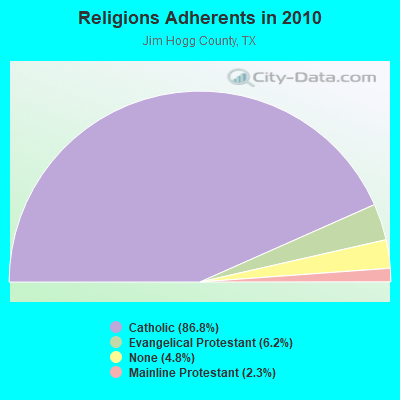
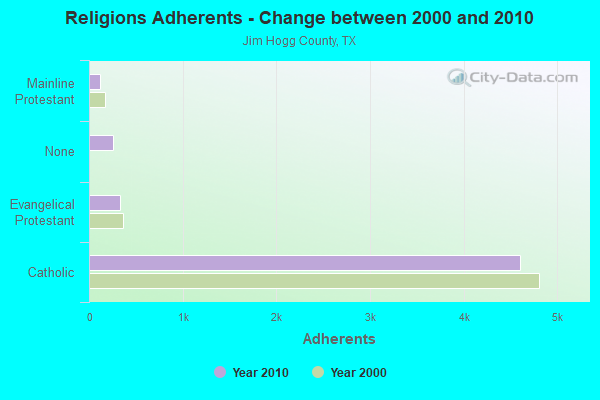
| Religion | Adherents | Congregations |
|---|---|---|
| Catholic | 4,600 | 4 |
| Evangelical Protestant | 326 | 3 |
| Mainline Protestant | 120 | 2 |
| Other | - | 1 |
| None | 254 | - |
Food Environment Statistics:
| Here: | 14.14 / 10,000 pop. |
| Texas: | 1.47 / 10,000 pop. |
| This county: | 4.04 / 10,000 pop. |
| State: | 1.11 / 10,000 pop. |
| This county: | 8.08 / 10,000 pop. |
| Texas: | 3.95 / 10,000 pop. |
| This county: | 6.06 / 10,000 pop. |
| State: | 6.13 / 10,000 pop. |
| This county: | 10.0% |
| Texas: | 8.9% |
| This county: | 26.9% |
| Texas: | 26.6% |
| This county: | 15.2% |
| Texas: | 15.7% |
Strongest AM radio stations in North Jim Hogg:
- KGBT (1530 AM; 50 kW; HARLINGEN, TX; Owner: TICHENOR LICENSE CORPORATION)
- KCTA (1030 AM; 50 kW; CORPUS CHRISTI, TX; Owner: BROADCASTING CORPORATION OF THE SOUTHWEST)
- KVOZ (890 AM; 12 kW; DEL MAR HILLS, TX; Owner: CONSOLIDATED RADIO, INC.)
- KKYX (680 AM; 50 kW; SAN ANTONIO, TX; Owner: CXR HOLDINGS, INC.)
- KTKR (760 AM; 50 kW; SAN ANTONIO, TX; Owner: CCB TEXAS LICENSES, L.P.)
- KURV (710 AM; 10 kW; EDINBURG, TX; Owner: VOICE OF VALLEY AGRICULTURE, INC.)
- WOAI (1200 AM; 50 kW; SAN ANTONIO, TX; Owner: CCB TEXAS LICENSES, L.P.)
- KUBR (1210 AM; 10 kW; SAN JUAN, TX; Owner: PAULINO BERNAL)
- KVJY (840 AM; 5 kW; PHARR, TX; Owner: RADIO UNICA OF MCALLEN LICENSE CORP.)
- KRIO (910 AM; 5 kW; MCALLEN, TX; Owner: RIO GRANDE BIBLE INSTITUTE, INC.)
- KENS (1160 AM; 25 kW; SAN ANTONIO, TX; Owner: KENS-TV, INC.)
- KTRH (740 AM; 50 kW; HOUSTON, TX; Owner: AMFM TEXAS LICENSES LIMITED PARTNERSHIP)
- KILE (1560 AM; 50 kW; BELLAIRE, TX; Owner: THE RAFTT CORPORATION)
Strongest FM radio stations in North Jim Hogg:
- KAZF (91.9 FM; HEBBRONVILLE, TX; Owner: PAULINO BERNAL EVANGELISM)
- KEKO (101.7 FM; HEBBRONVILLE, TX; Owner: LA NUEVA CADENA RADIO LUZ INC.)
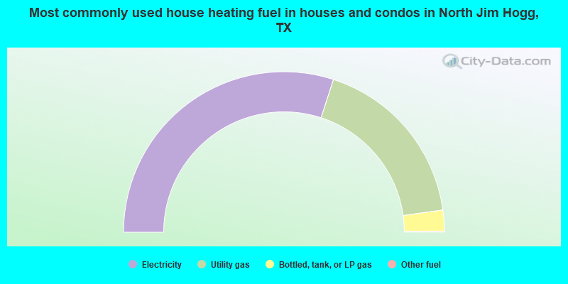
- 60.0%Electricity
- 35.6%Utility gas
- 4.2%Bottled, tank, or LP gas
- 0.2%Other fuel
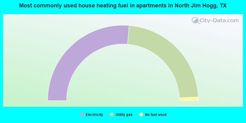
- 52.6%Electricity
- 45.9%Utility gas
- 1.5%No fuel used
North Jim Hogg compared to Texas state average:
- Median household income below state average.
- Median house value below state average.
- Unemployed percentage below state average.
- Black race population percentage significantly below state average.
- Hispanic race population percentage above state average.
- Foreign-born population percentage significantly below state average.
- Length of stay since moving in significantly above state average.
- Number of rooms per house significantly below state average.
- House age significantly below state average.
- Percentage of population with a bachelor's degree or higher significantly below state average.