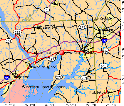
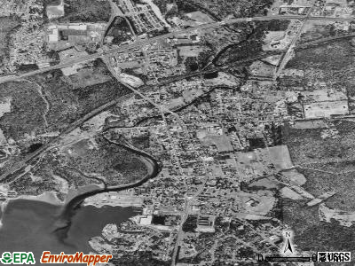
North East, Maryland
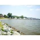
North East: At The Bay In North East. MD

North East: full bloom
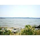
North East: North East. MD
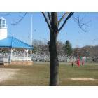
North East: north east town park
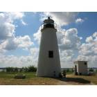
North East: turkey point light house
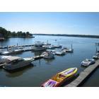
North East: Taken from the Nautigoose Resturant, North East, MD
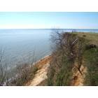
North East: Elk Neck State Park
- add
your
Submit your own pictures of this town and show them to the world
- OSM Map
- General Map
- Google Map
- MSN Map
Population change since 2000: +51.2%
| Males: 2,342 | |
| Females: 1,790 |
| Median resident age: | 36.1 years |
| Maryland median age: | 39.7 years |
Zip codes: 21901.
| North East: | $84,811 |
| MD: | $94,991 |
Estimated per capita income in 2022: $47,305 (it was $18,287 in 2000)
North East town income, earnings, and wages data
Estimated median house or condo value in 2022: $239,880 (it was $91,200 in 2000)
| North East: | $239,880 |
| MD: | $398,100 |
Mean prices in 2022: all housing units: $296,679; detached houses: $340,547; townhouses or other attached units: $250,371; in 3-to-4-unit structures: $184,612; in 5-or-more-unit structures: $349,379
Median gross rent in 2022: $1,242.
(16.0% for White Non-Hispanic residents, 9.4% for Black residents, 7.1% for two or more races residents)
Detailed information about poverty and poor residents in North East, MD


- 3,16277.1%White alone
- 58414.2%Black alone
- 2826.9%Two or more races
- 631.5%Hispanic
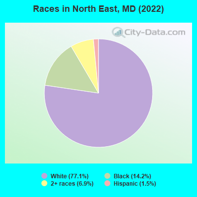
Races in North East detailed stats: ancestries, foreign born residents, place of birth
According to our research of Maryland and other state lists, there were 29 registered sex offenders living in North East, Maryland as of May 06, 2024.
The ratio of all residents to sex offenders in North East is 126 to 1.
Type |
2009 |
2010 |
2011 |
2012 |
2013 |
2014 |
2015 |
2016 |
2017 |
2018 |
2019 |
2020 |
2022 |
|---|---|---|---|---|---|---|---|---|---|---|---|---|---|
| Murders (per 100,000) | 0 (0.0) | 0 (0.0) | 0 (0.0) | 0 (0.0) | 0 (0.0) | 0 (0.0) | 0 (0.0) | 0 (0.0) | 0 (0.0) | 0 (0.0) | 0 (0.0) | 0 (0.0) | 0 (0.0) |
| Rapes (per 100,000) | 0 (0.0) | 0 (0.0) | 0 (0.0) | 1 (26.9) | 0 (0.0) | 0 (0.0) | 0 (0.0) | 0 (0.0) | 0 (0.0) | 0 (0.0) | 0 (0.0) | 0 (0.0) | 0 (0.0) |
| Robberies (per 100,000) | 5 (174.1) | 5 (140.0) | 6 (166.4) | 5 (134.4) | 2 (54.3) | 4 (108.0) | 3 (80.5) | 5 (133.9) | 2 (54.6) | 3 (82.4) | 6 (164.9) | 1 (27.4) | 0 (0.0) |
| Assaults (per 100,000) | 9 (313.4) | 5 (140.0) | 3 (83.2) | 3 (80.7) | 5 (135.7) | 1 (27.0) | 0 (0.0) | 5 (133.9) | 2 (54.6) | 4 (109.8) | 6 (164.9) | 16 (438.6) | 8 (195.1) |
| Burglaries (per 100,000) | 24 (835.7) | 23 (643.9) | 31 (859.7) | 18 (484.0) | 14 (379.9) | 20 (539.8) | 12 (321.9) | 11 (294.6) | 7 (191.2) | 4 (109.8) | 17 (467.2) | 16 (438.6) | 5 (122.0) |
| Thefts (per 100,000) | 134 (4,666) | 102 (2,856) | 109 (3,023) | 138 (3,711) | 107 (2,904) | 92 (2,483) | 95 (2,548) | 45 (1,205) | 71 (1,939) | 58 (1,593) | 63 (1,731) | 96 (2,632) | 81 (1,976) |
| Auto thefts (per 100,000) | 13 (452.6) | 11 (308.0) | 5 (138.7) | 10 (268.9) | 9 (244.2) | 2 (54.0) | 2 (53.6) | 8 (214.2) | 4 (109.3) | 6 (164.7) | 5 (137.4) | 4 (109.6) | 4 (97.6) |
| Arson (per 100,000) | 5 (174.1) | 2 (56.0) | 5 (138.7) | 0 (0.0) | 0 (0.0) | 3 (81.0) | 2 (53.6) | 5 (133.9) | 7 (191.2) | 1 (27.5) | 0 (0.0) | 0 (0.0) | 0 (0.0) |
| City-Data.com crime index | 396.2 | 253.9 | 258.7 | 281.8 | 205.7 | 179.2 | 152.9 | 152.9 | 127.0 | 131.2 | 195.4 | 240.7 | 134.4 |
The City-Data.com crime index weighs serious crimes and violent crimes more heavily. Higher means more crime, U.S. average is 246.1. It adjusts for the number of visitors and daily workers commuting into cities.
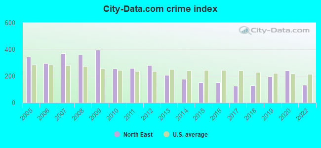
Crime rate in North East detailed stats: murders, rapes, robberies, assaults, burglaries, thefts, arson
Full-time law enforcement employees in 2021, including police officers: 11 (10 officers - 9 male; 1 female).
| Officers per 1,000 residents here: | 2.77 |
| Maryland average: | 2.47 |
 Recent articles from our blog. Our writers, many of them Ph.D. graduates or candidates, create easy-to-read articles on a wide variety of topics.

 | Do Marylanders consider themselves "North Eastern" (62 replies) |
| North East, MD the town (4 replies) |
| Md Redistricting Plans, Proposals, & Dreams (87 replies) |
| Population decline in baltimore (150 replies) |
| What's your favorite Maryland town and why? (47 replies) |
| Relo advice: from southern NJ, to Midlo VA, now MD (41 replies) |
Latest news from North East, MD collected exclusively by city-data.com from local newspapers, TV, and radio stations
Ancestries: European (25.5%), Irish (10.3%), German (9.2%), Polish (6.7%), American (6.1%), Haitian (5.3%).
Current Local Time: EST time zone
Incorporated in 1849
Elevation: 10 feet
Land area: 1.58 square miles.
Population density: 2,617 people per square mile (average).
166 residents are foreign born (3.3% Latin America, 0.5% Europe).
| This town: | 4.0% |
| Maryland: | 15.7% |
Median real estate property taxes paid for housing units with mortgages in 2022: $2,982 (1.2%)
Median real estate property taxes paid for housing units with no mortgage in 2022: $2,384 (1.6%)
Nearest city with pop. 50,000+: Greater Newark, DE (11.9 miles  , pop. 67,114).
Nearest city with pop. 200,000+: Baltimore, MD (41.3 miles , pop. 651,154).
Nearest city with pop. 1,000,000+: Philadelphia, PA (50.5 miles , pop. 1,517,550).
Nearest cities:
), )Latitude: 39.60 N, Longitude: 75.94 W
Area codes: 443, 410
North East, Maryland accommodation & food services, waste management - Economy and Business Data
| Here: | 2.1% |
| Maryland: | 2.0% |
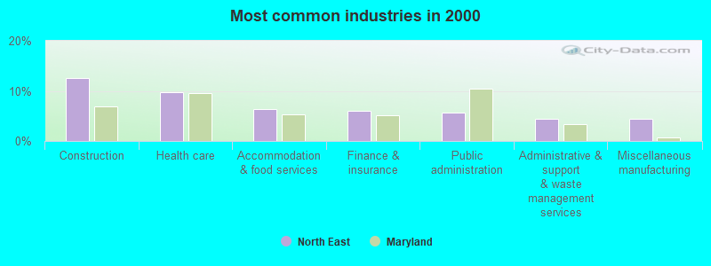
- Construction (12.5%)
- Health care (9.7%)
- Accommodation & food services (6.4%)
- Finance & insurance (6.0%)
- Public administration (5.6%)
- Administrative & support & waste management services (4.4%)
- Miscellaneous manufacturing (4.4%)
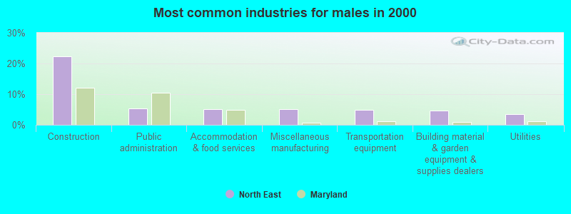
- Construction (22.4%)
- Public administration (5.3%)
- Accommodation & food services (5.0%)
- Miscellaneous manufacturing (5.0%)
- Transportation equipment (4.9%)
- Building material & garden equipment & supplies dealers (4.6%)
- Utilities (3.5%)
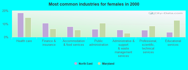
- Health care (18.5%)
- Finance & insurance (10.6%)
- Accommodation & food services (8.0%)
- Public administration (6.0%)
- Administrative & support & waste management services (5.6%)
- Professional, scientific, technical services (5.4%)
- Educational services (3.8%)
- Other sales and related occupations, including supervisors (4.7%)
- Assemblers and fabricators (4.1%)
- Computer specialists (4.0%)
- Electrical equipment mechanics and other installation, maintenance, and repair workers, including supervisors (3.9%)
- Other production occupations, including supervisors (3.8%)
- Construction traders workers except carpenters, electricians, painters, plumbers, and construction laborers (3.5%)
- Building and grounds cleaning and maintenance occupations (3.4%)

- Electrical equipment mechanics and other installation, maintenance, and repair workers, including supervisors (7.2%)
- Construction traders workers except carpenters, electricians, painters, plumbers, and construction laborers (6.4%)
- Other sales and related occupations, including supervisors (5.7%)
- Carpenters (5.0%)
- Other production occupations, including supervisors (4.5%)
- Other management occupations, except farmers and farm managers (3.9%)
- Driver/sales workers and truck drivers (3.9%)
- Assemblers and fabricators (6.5%)
- Information and record clerks, except customer service representatives (5.4%)
- Cashiers (4.6%)
- Other office and administrative support workers, including supervisors (4.6%)
- Computer specialists (4.2%)
- Secretaries and administrative assistants (4.2%)
- Financial clerks, except bookkeeping, accounting and auditing clerks (4.1%)
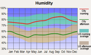
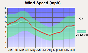
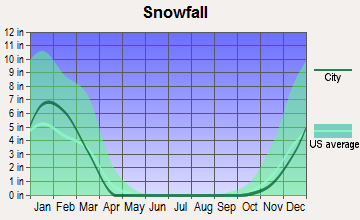
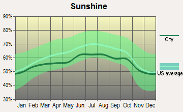
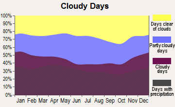
Average climate in North East, Maryland
Based on data reported by over 4,000 weather stations
|
|

(lower is better)
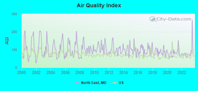
Air Quality Index (AQI) level in 2023 was 100. This is worse than average.
| City: | 100 |
| U.S.: | 73 |
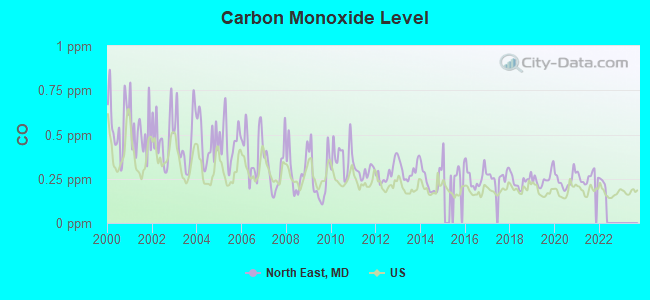
Carbon Monoxide (CO) [ppm] level in 2021 was 0.259. This is about average. Closest monitor was 15.5 miles away from the city center.
| City: | 0.259 |
| U.S.: | 0.251 |
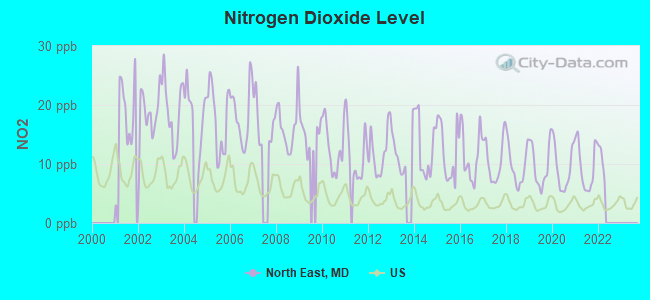
Nitrogen Dioxide (NO2) [ppb] level in 2021 was 9.56. This is significantly worse than average. Closest monitor was 6.0 miles away from the city center.
| City: | 9.56 |
| U.S.: | 5.11 |
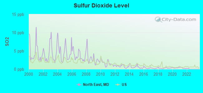
Sulfur Dioxide (SO2) [ppb] level in 2021 was 0.291. This is significantly better than average. Closest monitor was 6.0 miles away from the city center.
| City: | 0.291 |
| U.S.: | 1.515 |
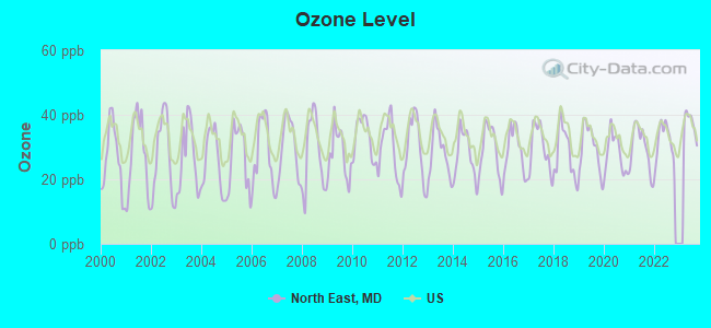
Ozone [ppb] level in 2023 was 37.3. This is about average. Closest monitor was 8.2 miles away from the city center.
| City: | 37.3 |
| U.S.: | 33.3 |
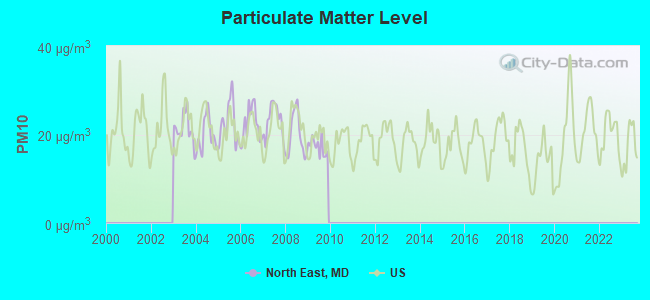
Particulate Matter (PM10) [µg/m3] level in 2009 was 17.3. This is about average. Closest monitor was 6.0 miles away from the city center.
| City: | 17.3 |
| U.S.: | 19.2 |
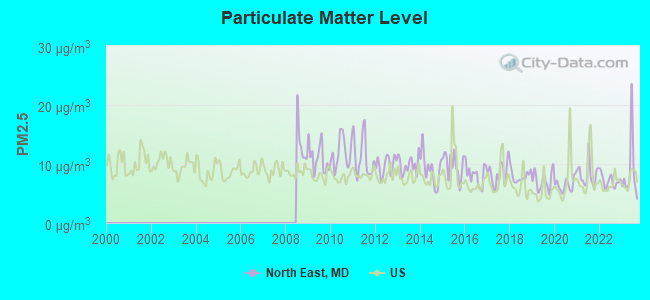
Particulate Matter (PM2.5) [µg/m3] level in 2023 was 8.57. This is about average. Closest monitor was 8.2 miles away from the city center.
| City: | 8.57 |
| U.S.: | 8.11 |
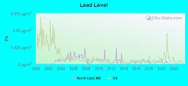
Lead (Pb) [µg/m3] level in 2020 was 0.00328. This is significantly better than average. Closest monitor was 6.0 miles away from the city center.
| City: | 0.00328 |
| U.S.: | 0.00931 |
Tornado activity:
North East-area historical tornado activity is slightly above Maryland state average. It is 14% greater than the overall U.S. average.
On 7/27/1994, a category F3 (max. wind speeds 158-206 mph) tornado 12.4 miles away from the North East town center injured 11 people and caused between $500,000 and $5,000,000 in damages.
On 4/28/1961, a category F3 tornado 20.4 miles away from the town center caused between $5000 and $50,000 in damages.
Earthquake activity:
North East-area historical earthquake activity is significantly above Maryland state average. It is 63% smaller than the overall U.S. average.On 8/23/2011 at 17:51:04, a magnitude 5.8 (5.8 MW, Depth: 3.7 mi, Class: Moderate, Intensity: VI - VII) earthquake occurred 158.9 miles away from North East center
On 1/16/1994 at 01:49:16, a magnitude 4.6 (4.6 MB, 4.6 LG, Depth: 3.1 mi, Class: Light, Intensity: IV - V) earthquake occurred 50.7 miles away from the city center
On 1/16/1994 at 00:42:43, a magnitude 4.2 (4.2 MB, 4.0 LG, Depth: 3.1 mi) earthquake occurred 50.4 miles away from North East center
On 11/30/2017 at 21:47:31, a magnitude 4.1 (4.1 MW, Depth: 6.1 mi) earthquake occurred 39.0 miles away from the city center
On 9/25/1998 at 19:52:52, a magnitude 5.2 (4.8 MB, 4.3 MS, 5.2 LG, 4.5 MW, Depth: 3.1 mi) earthquake occurred 268.1 miles away from the city center
On 8/25/2011 at 05:07:52, a magnitude 4.5 (4.5 ML, Depth: 4.2 mi) earthquake occurred 158.1 miles away from North East center
Magnitude types: regional Lg-wave magnitude (LG), body-wave magnitude (MB), local magnitude (ML), surface-wave magnitude (MS), moment magnitude (MW)
Natural disasters:
The number of natural disasters in Cecil County (18) is near the US average (15).Major Disasters (Presidential) Declared: 13
Emergencies Declared: 5
Causes of natural disasters: Hurricanes: 7, Snowstorms: 4, Winter Storms: 4, Floods: 2, Tropical Storms: 2, Blizzard: 1, Heavy Rain: 1, Snowfall: 1, Other: 1 (Note: some incidents may be assigned to more than one category).
Hospitals and medical centers near North East:
- LAURELWOOD CARE CENTER AT ELKTON (Nursing Home, about 6 miles away; ELKTON, MD)
- UNION HOSPITAL OF CECIL COUNTY Acute Care Hospitals (about 6 miles away; ELKTON, MD)
- FMC - ELKTON (Dialysis Facility, about 6 miles away; ELKTON, MD)
- DEVINE HAVEN CONV HOME (Nursing Home, about 7 miles away; ELKTON, MD)
- CALVERT MANOR HEALTH CARE CENT (Nursing Home, about 8 miles away; RISING SUN, MD)
- CALVERT MANOR NRS HOME (Nursing Home, about 8 miles away; RISING SUN, MD)
- AMEDISYS HOME HEALTH OF ELKTON (Home Health Center, about 9 miles away; ELKTON, MD)
Airports located in North East:
- High Valley Airport (16MD) (Runways: 1)
Amtrak stations near North East:
College/University in North East:
Colleges/universities with over 2000 students nearest to North East:
- University of Delaware (about 12 miles; Newark, DE; Full-time enrollment: 20,078)
- Lincoln University of Pennsylvania (about 15 miles; Lincoln University, PA; FT enrollment: 2,042)
- Harford Community College (about 19 miles; Bel Air, MD; FT enrollment: 4,530)
- Wilmington University (about 20 miles; New Castle, DE; FT enrollment: 10,072)
- Delaware Technical Community College-Stanton/Wilmington (about 23 miles; Wilmington, DE; FT enrollment: 4,972)
- West Chester University of Pennsylvania (about 31 miles; West Chester, PA; FT enrollment: 14,492)
- Neumann University (about 33 miles; Aston, PA; FT enrollment: 2,622)
Public high schools in North East:
- NORTH EAST HIGH (Location: 300 IRISHTOWN RD, Grades: 9-12)
- RISING SUN HIGH (Location: 100 TIGER DR, Grades: 9-12)
Private high schools in North East:
Public elementary/middle schools in North East:
- BAY VIEW ELEMENTARY (Location: 910 NORTH EAST RD, Grades: PK-5)
- NORTH EAST ELEMENTARY (Location: 301 THOMAS AVE, Grades: PK-5)
- NORTH EAST MIDDLE (Location: 200 E CECIL AVE, Grades: 6-8)
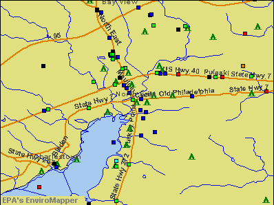
Points of interest:
Notable locations in North East: Upper Bay Museum (A), North East Volunteer Fire Company (B), North East Branch Cecil County Public Library (C), Town of North East Police Department (D). Display/hide their locations on the map
Churches in North East include: First Pentecostal Church (A), Mount Carmel Baptist Church (B), North East Baptist Church (C), North East United Methodist Church (D), Saint Mary Annes Episcopal Church (E), First Baptist Church of North East (F). Display/hide their locations on the map
Cemetery: Memorial Cemetery (1). Display/hide its location on the map
Streams, rivers, and creeks: North East Creek (A), Stony Run (B). Display/hide their locations on the map
Park in North East: North East Community Park (1). Display/hide its location on the map
Hotels: Holiday Inn Express Hotel & Suites (101 Hotel Plaza), Circle Motel (1921 West Pulaski Highway), Best Western Inn & Suites (39 Elwoods Rd), Crystal Inn North East (1 Center Drive), Maryland Manor Motel (1975 Pulaski Highway), Green Acres Motel (1974 West Pulasky Highway).
Drinking water stations with addresses in North East and their reported violations in the past:
TOWN OF NORTH EAST (Population served: 5,190, Surface water):Past health violations:TOWN & COUNTRY MOBILE HOME PARK (Population served: 450, Groundwater):Past monitoring violations:
- MCL, Average - Between JUL-2010 and SEP-2010, Contaminant: Total Haloacetic Acids (HAA5). Follow-up actions: St Compliance achieved (DEC-31-2010)
- MCL, Average - Between APR-2010 and JUN-2010, Contaminant: Total Haloacetic Acids (HAA5). Follow-up actions: St Violation/Reminder Notice (AUG-24-2010), St Public Notif requested (AUG-24-2010), St Compliance achieved (DEC-31-2010)
- MCL, Average - Between JAN-2010 and MAR-2010, Contaminant: TTHM. Follow-up actions: St Compliance achieved (JUN-30-2010)
- MCL, Average - Between JAN-2010 and MAR-2010, Contaminant: Total Haloacetic Acids (HAA5). Follow-up actions: St Compliance achieved (DEC-31-2010)
- MCL, Average - Between OCT-2009 and DEC-2009, Contaminant: TTHM. Follow-up actions: St Compliance achieved (JUN-30-2010)
- MCL, Average - Between OCT-2009 and DEC-2009, Contaminant: Total Haloacetic Acids (HAA5). Follow-up actions: St Compliance achieved (DEC-31-2010)
- 27 other older health violations
- Treatment Technique Precursor Removal - Between APR-2013 and JUN-2013, Contaminant: CARBON, TOTAL. Follow-up actions: St Public Notif requested (AUG-06-2013), St Violation/Reminder Notice (AUG-06-2013), St Compliance achieved (SEP-30-2013), St Public Notif received (OCT-25-2013)
- Monitoring and Reporting (DBP) - Between APR-2011 and JUN-2011, Contaminant: CARBON, TOTAL. Follow-up actions: St Violation/Reminder Notice (OCT-03-2011), St Compliance achieved (OCT-10-2011)
- Monitoring and Reporting (DBP) - Between JAN-2011 and MAR-2011, Contaminant: CARBON, TOTAL. Follow-up actions: St Violation/Reminder Notice (OCT-03-2011), St Compliance achieved (OCT-10-2011)
- Monitoring and Reporting (DBP) - Between OCT-2010 and DEC-2010, Contaminant: CARBON, TOTAL. Follow-up actions: St Violation/Reminder Notice (OCT-03-2011), St Compliance achieved (OCT-10-2011)
- Monitoring and Reporting (DBP) - Between JUL-2010 and SEP-2010, Contaminant: CARBON, TOTAL. Follow-up actions: St Violation/Reminder Notice (OCT-03-2011), St Compliance achieved (OCT-10-2011)
- 2 minor monitoring violations
- One regular monitoring violation
- 3 other older monitoring violations
Past health violations:CAMP SANDY COVE - DINING HALL (Address: 60 SANDY COVE ROAD , Serves WV, Population served: 200, Groundwater):Past monitoring violations:
- Public Education - In NOV-30-2009, Contaminant: Lead and Copper Rule. Follow-up actions: St Compliance achieved (AUG-08-2011)
- Lead Consumer Notice - In JAN-01-2014, Contaminant: Lead and Copper Rule. Follow-up actions: St Violation/Reminder Notice (SEP-10-2013)
- Lead Consumer Notice - In OCT-01-2012, Contaminant: Lead and Copper Rule. Follow-up actions: St Violation/Reminder Notice (MAY-01-2012)
Past monitoring violations:CECILTON MANOR MOBILE HOME PARK (Address: P.O. DRAWER S , Population served: 60, Groundwater):
- Monitoring of Treatment (SWTR-Unfilt/GWR) - In SEP-2013, Contaminant: GROUNDWATER RULE. Follow-up actions: St Formal NOV issued (NOV-06-2013), St Compliance achieved (NOV-21-2013)
- Monitoring of Treatment (SWTR-Unfilt/GWR) - In SEP-2012, Contaminant: GROUNDWATER RULE. Follow-up actions: St Public Notif requested (NOV-14-2012), St Formal NOV issued (NOV-14-2012), St Public Notif received (JUN-12-2013), St Compliance achieved (SEP-19-2013)
- Monitoring of Treatment (SWTR-Unfilt/GWR) - In SEP-2011, Contaminant: GROUNDWATER RULE. Follow-up actions: St Public Notif requested (NOV-15-2011), St Formal NOV issued (NOV-15-2011), St Compliance achieved (JUL-31-2012), St Public Notif received (JUN-12-2013)
- Monitoring of Treatment (SWTR-Unfilt/GWR) - In SEP-2010, Contaminant: GROUNDWATER RULE. Follow-up actions: St Formal NOV issued (NOV-05-2010), St Compliance achieved (APR-11-2011)
- Monitoring, Repeat Major (TCR) - Between JUL-2005 and SEP-2005, Contaminant: Coliform (TCR). Follow-up actions: St Public Notif requested (OCT-29-2005), St Formal NOV issued (OCT-29-2005), St Compliance achieved (JUL-10-2006), St Public Notif received (JUL-06-2007)
- One routine major monitoring violation
- One minor monitoring violation
- 3 regular monitoring violations
Past monitoring violations:CAMP SANDY COVE - OFFICE (Address: 60 SANDY COVE ROAD , Serves WV, Population served: 40, Groundwater):
- Follow-up Or Routine LCR Tap M/R - In OCT-01-2005, Contaminant: Lead and Copper Rule. Follow-up actions: St Violation/Reminder Notice (2 times from SEP-07-2006 to SEP-10-2007), St Compliance achieved (NOV-05-2007)
Past monitoring violations:SANDY COVE MINISTRIES (Population served: 35, Groundwater):
- Monitoring of Treatment (SWTR-Unfilt/GWR) - In SEP-2013, Contaminant: GROUNDWATER RULE. Follow-up actions: St Formal NOV issued (NOV-06-2013), St Compliance achieved (NOV-21-2013)
- Monitoring of Treatment (SWTR-Unfilt/GWR) - In SEP-2012, Contaminant: GROUNDWATER RULE. Follow-up actions: St Public Notif requested (NOV-14-2012), St Formal NOV issued (NOV-14-2012), St Public Notif received (AUG-01-2013), St Compliance achieved (SEP-19-2013)
- Monitoring of Treatment (SWTR-Unfilt/GWR) - In AUG-2012, Contaminant: GROUNDWATER RULE. Follow-up actions: St Public Notif requested (OCT-11-2012), St Formal NOV issued (OCT-11-2012), St Public Notif received (AUG-01-2013), St Compliance achieved (SEP-19-2013)
- Monitoring of Treatment (SWTR-Unfilt/GWR) - In JUL-2012, Contaminant: GROUNDWATER RULE. Follow-up actions: St Public Notif requested (SEP-08-2012), St Formal NOV issued (SEP-08-2012), St Public Notif received (AUG-01-2013), St Compliance achieved (SEP-19-2013)
- Monitoring of Treatment (SWTR-Unfilt/GWR) - In SEP-2011, Contaminant: GROUNDWATER RULE. Follow-up actions: St Public Notif requested (NOV-15-2011), St Formal NOV issued (NOV-15-2011), St Public Notif received (AUG-01-2013), St Compliance achieved (SEP-19-2013)
- One routine major monitoring violation
- 2 regular monitoring violations
- 4 other older monitoring violations
Past health violations:WAYSIDE SNACK BAR (Address: 1725 TURKEY POINT ROAD , Population served: 30, Groundwater):Past monitoring violations:
- MCL, Monthly (TCR) - In OCT-2010, Contaminant: Coliform. Follow-up actions: St Violation/Reminder Notice (JAN-05-2011), St Public Notif requested (JAN-05-2011), St Compliance achieved (JAN-12-2011), St Public Notif received (JAN-12-2011)
- MCL, Monthly (TCR) - In JUL-2010, Contaminant: Coliform. Follow-up actions: St Violation/Reminder Notice (JUL-30-2010), St Public Notif requested (AUG-12-2010), St Public Notif received (AUG-23-2010), St Compliance achieved (JAN-12-2011)
- Follow-up Or Routine LCR Tap M/R - In OCT-01-2013, Contaminant: Lead and Copper Rule. Follow-up actions: St Violation/Reminder Notice (MAR-19-2013)
- Follow-up Or Routine LCR Tap M/R - In OCT-01-2009, Contaminant: Lead and Copper Rule. Follow-up actions: St Violation/Reminder Notice (OCT-27-2009), St Public Notif requested (OCT-27-2009), St Violation/Reminder Notice (MAR-22-2010), St Compliance achieved (SEP-20-2010)
- 5 routine major monitoring violations
- One regular monitoring violation
Past health violations:UNWIND, CCC AND CATERING (Address: 5411 TURLEY POINT RD , Population served: 30, Groundwater):
- MCL, Monthly (TCR) - In JUN-2009, Contaminant: Coliform. Follow-up actions: St Violation/Reminder Notice (JUL-30-2009), St Compliance achieved (MAY-26-2010)
Past health violations:
- MCL, Acute (TCR) - In OCT-2005, Contaminant: Coliform. Follow-up actions: St Violation/Reminder Notice (2 times from AUG-04-2005 to OCT-14-2005), St Compliance achieved (OCT-24-2005)
- MCL, Acute (TCR) - In JUL-2005, Contaminant: Coliform. Follow-up actions: St Violation/Reminder Notice (2 times from AUG-04-2005 to OCT-14-2005), St Compliance achieved (OCT-24-2005)
| This town: | 2.5 people |
| Maryland: | 2.6 people |
| This town: | 62.9% |
| Whole state: | 67.1% |
| This town: | 11.4% |
| Whole state: | 6.4% |
Likely homosexual households (counted as self-reported same-sex unmarried-partner households)
- Lesbian couples: 0.1% of all households
- Gay men: 0.1% of all households
Banks with branches in North East (2011 data):
- PNC Bank, National Association: Route 40 Branch, North East Main, North East Branch. Info updated 2012/03/20: Bank assets: $263,309.6 mil, Deposits: $197,343.0 mil, headquarters in Wilmington, DE, positive income, Commercial Lending Specialization, 3085 total offices, Holding Company: Pnc Financial Services Group, Inc., The
- Cecil Bank: Turkey Point Branch at 1223-B Turkey Point Road, branch established on 2004/06/21; 108 North East Plaza Branch at 108 North East Plaza, branch established on 1959/10/07. Info updated 2008/07/14: Bank assets: $463.0 mil, Deposits: $339.9 mil, headquarters in Elkton, MD, negative income in the last year, Commercial Lending Specialization, 11 total offices, Holding Company: Cecil Bancorp, Inc.
For population 15 years and over in North East:
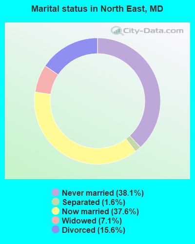
- Never married: 38.1%
- Now married: 37.6%
- Separated: 1.6%
- Widowed: 7.1%
- Divorced: 15.6%
For population 25 years and over in North East:
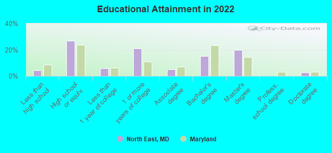
- High school or higher: 93.9%
- Bachelor's degree or higher: 33.9%
- Graduate or professional degree: 19.2%
- Unemployed: 5.9%
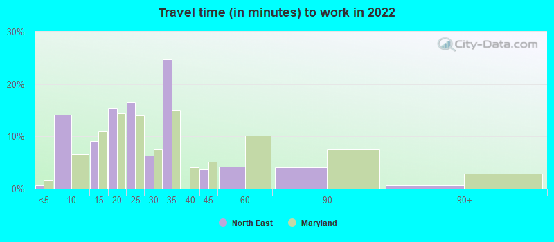
- Mean travel time to work (commute): 24.2 minutes
| Here: | 9.9 |
| Maryland average: | 12.7 |
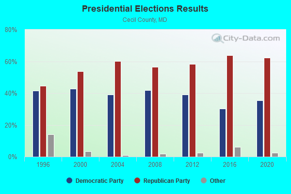
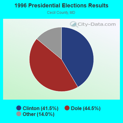
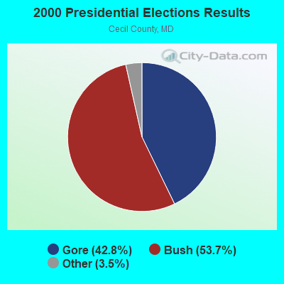
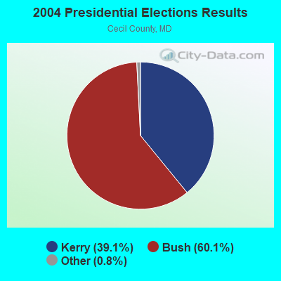
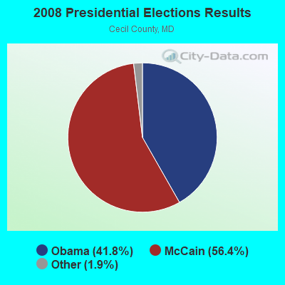
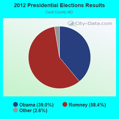
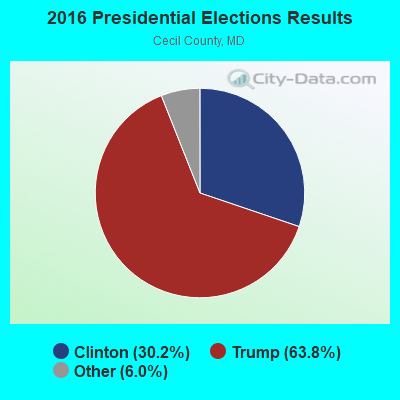
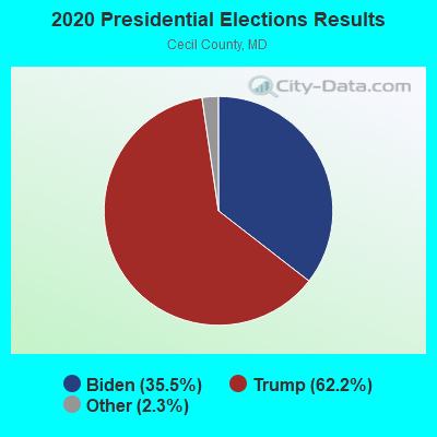
Graphs represent county-level data. Detailed 2008 Election Results
Religion statistics for North East, MD (based on Cecil County data)
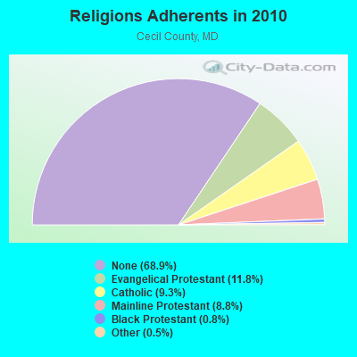
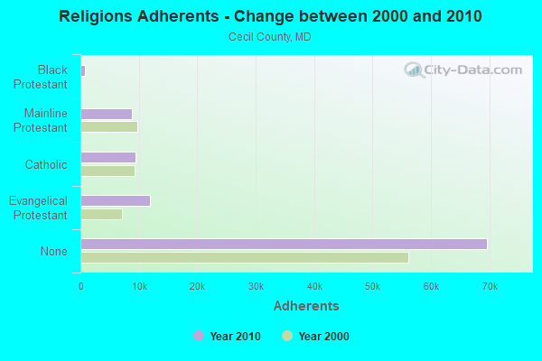
| Religion | Adherents | Congregations |
|---|---|---|
| Evangelical Protestant | 11,922 | 47 |
| Catholic | 9,440 | 8 |
| Mainline Protestant | 8,873 | 41 |
| Black Protestant | 784 | 6 |
| Other | 465 | 2 |
| None | 69,624 | - |
Food Environment Statistics:
| Here: | 2.01 / 10,000 pop. |
| State: | 1.96 / 10,000 pop. |
| Cecil County: | 1.11 / 10,000 pop. |
| Maryland: | 1.22 / 10,000 pop. |
| Cecil County: | 3.32 / 10,000 pop. |
| Maryland: | 2.05 / 10,000 pop. |
| This county: | 4.73 / 10,000 pop. |
| State: | 5.40 / 10,000 pop. |
| Cecil County: | 8.2% |
| Maryland: | 9.1% |
| Cecil County: | 27.8% |
| Maryland: | 26.7% |
| Cecil County: | 18.0% |
| Maryland: | 15.5% |
Health and Nutrition:
| North East: | 50.0% |
| Maryland: | 50.1% |
| Here: | 48.9% |
| Maryland: | 47.6% |
| North East: | 28.3 |
| State: | 28.8 |
| North East: | 24.0% |
| State: | 20.0% |
| North East: | 9.3% |
| Maryland: | 11.3% |
| North East: | 6.9 |
| Maryland: | 6.8 |
| North East: | 32.6% |
| Maryland: | 34.1% |
| Here: | 58.1% |
| State: | 56.5% |
| North East: | 80.3% |
| Maryland: | 80.5% |
More about Health and Nutrition of North East, MD Residents
| Local government employment and payroll (March 2022) | |||||
| Function | Full-time employees | Monthly full-time payroll | Average yearly full-time wage | Part-time employees | Monthly part-time payroll |
|---|---|---|---|---|---|
| Police Protection - Officers | 13 | $70,879 | $65,427 | 0 | $0 |
| Water Supply | 5 | $28,989 | $69,574 | 0 | $0 |
| Streets and Highways | 4 | $15,044 | $45,132 | 0 | $0 |
| Other Government Administration | 4 | $29,640 | $88,920 | 1 | $2,905 |
| Financial Administration | 2 | $10,425 | $62,550 | 1 | $1,360 |
| Judicial and Legal | 1 | $4,026 | $48,312 | 0 | $0 |
| Police - Other | 0 | $0 | 2 | $478 | |
| Totals for Government | 29 | $159,003 | $65,794 | 4 | $4,743 |
North East government finances - Expenditure in 2021 (per resident):
- Current Operations - Water Utilities: $3,000,000 ($726.04)
Police Protection: $1,322,000 ($319.94)
Regular Highways: $575,000 ($139.16)
Solid Waste Management: $264,000 ($63.89)
Central Staff Services: $255,000 ($61.71)
General Public Buildings: $118,000 ($28.56)
Parks and Recreation: $108,000 ($26.14)
Financial Administration: $88,000 ($21.30)
General - Other: $12,000 ($2.90)
Protective Inspection and Regulation - Other: $8,000 ($1.94)
Local Fire Protection: $8,000 ($1.94)
Judicial and Legal Services: $7,000 ($1.69)
- Other Capital Outlay - Police Protection: $42,000 ($10.16)
- Total Salaries and Wages: $2,622,000 ($634.56)
- Water Utilities - Interest on Debt: $472,000 ($114.23)
North East government finances - Revenue in 2021 (per resident):
- Charges - Solid Waste Management: $286,000 ($69.22)
Other: $189,000 ($45.74)
- Federal Intergovernmental - Other: $78,000 ($18.88)
- Local Intergovernmental - Other: $6,000 ($1.45)
General Local Government Support: $1,000 ($0.24)
- Miscellaneous - General Revenue - Other: $1,052,000 ($254.60)
Rents: $102,000 ($24.69)
Interest Earnings: $21,000 ($5.08)
Sale of Property: $3,000 ($0.73)
- Revenue - Water Utilities: $3,036,000 ($734.75)
- State Intergovernmental - Highways: $126,000 ($30.49)
Other: $72,000 ($17.42)
- Tax - Property: $2,023,000 ($489.59)
Individual Income: $449,000 ($108.66)
Other Selective Sales: $199,000 ($48.16)
Public Utility License: $63,000 ($15.25)
Occupation and Business License - Other: $12,000 ($2.90)
Amusements Sales: $9,000 ($2.18)
Other License: $7,000 ($1.69)
Amusements License: $1,000 ($0.24)
North East government finances - Debt in 2021 (per resident):
- Long Term Debt - Beginning Outstanding - Unspecified Public Purpose: $11,821,000 ($2860.84)
Outstanding Unspecified Public Purpose: $11,128,000 ($2693.13)
Retired Unspecified Public Purpose: $693,000 ($167.72)
North East government finances - Cash and Securities in 2021 (per resident):
- Bond Funds - Cash and Securities: $306,000 ($74.06)
- Other Funds - Cash and Securities: $10,927,000 ($2644.48)
| Businesses in North East, MD | ||||
| Name | Count | Name | Count | |
|---|---|---|---|---|
| Advance Auto Parts | 1 | McDonald's | 1 | |
| Best Western | 1 | Penske | 1 | |
| Burger King | 2 | Pizza Hut | 1 | |
| Cinnabon | 1 | Popeyes | 1 | |
| Comfort Inn | 1 | Rite Aid | 1 | |
| Cricket Wireless | 2 | Starbucks | 1 | |
| Dennys | 1 | Subway | 1 | |
| Domino's Pizza | 1 | T-Mobile | 1 | |
| Dunkin Donuts | 1 | UPS | 1 | |
| FedEx | 3 | Waffle House | 1 | |
| GameStop | 1 | Walgreens | 1 | |
| Holiday Inn | 1 | Walmart | 1 | |
| MasterBrand Cabinets | 1 | |||
Strongest AM radio stations in North East:
- WVCH (740 AM; 50 kW; CHESTER, PA; Owner: WVCH COMMUNICATIONS, INC.)
- WJSS (1330 AM; 5 kW; HAVRE DE GRACE, MD; Owner: PEOPLES BROADCAST NETWORK, LLC)
- WWLG (1370 AM; 50 kW; BALTIMORE, MD; Owner: M-10 BROADCASTING, INC.)
- WPEN (950 AM; 50 kW; PHILADELPHIA, PA; Owner: GREATER PHILADELPHIA RADIO, INC.)
- WCBM (680 AM; 50 kW; BALTIMORE, MD; Owner: WCBM MARYLAND, INC.)
- WBAL (1090 AM; 50 kW; BALTIMORE, MD; Owner: HEARST RADIO, INC.)
- WZZD (990 AM; 50 kW; PHILADELPHIA, PA; Owner: PENNSYLVANIA MEDIA ASSOCIATES, INC.)
- KYW (1060 AM; 50 kW; PHILADELPHIA, PA; Owner: INFINITY BROADCASTING OPERATIONS, INC.)
- WWJZ (640 AM; 50 kW; MOUNT HOLLY, NJ; Owner: ABC, INC.)
- WBIS (1190 AM; 50 kW; ANNAPOLIS, MD; Owner: NATIONS RADIO, LLC)
- WNWR (1540 AM; 50 kW; PHILADELPHIA, PA)
- WGOP (700 AM; daytime; 25 kW; WALKERSVILLE, MD; Owner: BIRACH BROADCASTING CORPORATION)
- WPHT (1210 AM; 50 kW; PHILADELPHIA, PA; Owner: INFINITY BROADCASTING OPERATIONS, INC.)
Strongest FM radio stations in North East:
- WOEL-FM (89.9 FM; ELKTON, MD; Owner: MARANATHA BIBLE INSTITUTE, INC.)
- WXCY (103.7 FM; HAVRE DE GRACE, MD; Owner: DELMARVA BROADCASTING COMPANY)
- WDAC (94.5 FM; LANCASTER, PA; Owner: WDAC RADIO COMPANY)
- WPLY (100.3 FM; MEDIA, PA; Owner: RADIO ONE LICENSES, LLC)
- WLIF (101.9 FM; BALTIMORE, MD; Owner: INFINITY WLIF, INC.)
- WWMX (106.5 FM; BALTIMORE, MD; Owner: INFINITY RADIO OPERATIONS INC.)
- WARM-FM (103.3 FM; YORK, PA; Owner: WSBA LICO, INC.)
- WROZ (101.3 FM; LANCASTER, PA; Owner: HALL COMMUNICATIONS, INC.)
- WIOV-FM (105.1 FM; EPHRATA, PA; Owner: REGENT BROADCASTING OF LANCASTER, INC.)
- WSOX (96.1 FM; RED LION, PA; Owner: LANCASTER-YORK BROADCASTING, LLC)
- WIYY (97.9 FM; BALTIMORE, MD; Owner: HEARST RADIO, INC.)
- WSTW (93.7 FM; WILMINGTON, DE; Owner: DELMARVA BROADCASTING COMPANY)
- WJBR-FM (99.5 FM; WILMINGTON, DE; Owner: NM LICENSING, LLC)
- WSMJ (104.3 FM; BALTIMORE, MD; Owner: CITICASTERS LICENSES, L.P.)
- WVUD (91.3 FM; NEWARK, DE; Owner: UNIVERSITYOF DELAWARE)
- WHFC (91.1 FM; BEL AIR, MD; Owner: HARFORD COMMUNITY COLLEGE)
TV broadcast stations around North East:
- WTSD-CA (Channel 14; WILMINGTON, DE; Owner: PRIORITY COMMUNICATIONS MINISTRIES, INC.)
- KYW-TV (Channel 3; PHILADELPHIA, PA; Owner: CBS BROADCASTING INC.)
- WBAL-TV (Channel 11; BALTIMORE, MD; Owner: WBAL HEARST-ARGYLE TV, INC. (CA CORP.))
- WMAR-TV (Channel 2; BALTIMORE, MD; Owner: SCRIPPS HOWARD BROADCASTING COMPANY)
- WBFF (Channel 45; BALTIMORE, MD; Owner: CHESAPEAKE TELEVISION LICENSEE, LLC)
- WNUV (Channel 54; BALTIMORE, MD; Owner: BALTIMORE (WNUV-TV) LICENSEE, INC.)
- WPHL-TV (Channel 17; PHILADELPHIA, PA; Owner: TRIBUNE TELEVISION COMPANY)
- WPPX (Channel 61; WILMINGTON, DE; Owner: PAXSON PHILADELPHIA LICENSE, INC.)
- WPVI-TV (Channel 6; PHILADELPHIA, PA; Owner: ABC, INC.)
- WPSG (Channel 57; PHILADELPHIA, PA; Owner: VIACOM STATIONS GROUP OF PHILADELPHIA INC.)
- WCAU (Channel 10; PHILADELPHIA, PA; Owner: NBC SUBSIDIARY (WCAU-TV), L.P.)
- WMPB (Channel 67; BALTIMORE, MD; Owner: MARYLAND PUBLIC BROADCASTING COMMISSION)
- WJZ-TV (Channel 13; BALTIMORE, MD; Owner: VIACOM INC.)
- National Bridge Inventory (NBI) Statistics
- 41Number of bridges
- 495ft / 151mTotal length
- $16,853,000Total costs
- 470,893Total average daily traffic
- 47,634Total average daily truck traffic
- 626,424Total future (year 2026) average daily traffic
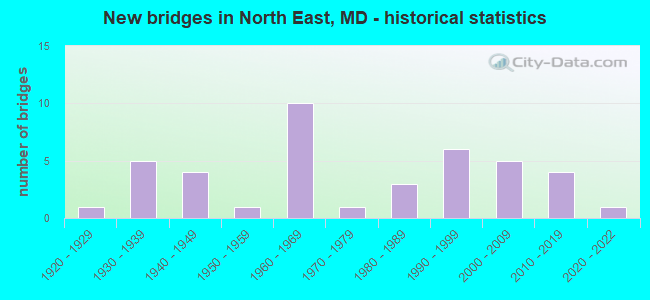
- New bridges - historical statistics
- 11920-1929
- 51930-1939
- 41940-1949
- 11950-1959
- 101960-1969
- 11970-1979
- 31980-1989
- 61990-1999
- 52000-2009
- 42010-2019
- 12020-2022
FCC Registered Antenna Towers: 48 (See the full list of FCC Registered Antenna Towers)
FCC Registered Broadcast Land Mobile Towers: 13 (See the full list of FCC Registered Broadcast Land Mobile Towers in North East, MD)
FCC Registered Microwave Towers: 7 (See the full list of FCC Registered Microwave Towers in this town)
FCC Registered Maritime Coast & Aviation Ground Towers: 2 (See the full list of FCC Registered Maritime Coast & Aviation Ground Towers)
FCC Registered Amateur Radio Licenses: 65 (See the full list of FCC Registered Amateur Radio Licenses in North East)
FAA Registered Aircraft: 9 (See the full list of FAA Registered Aircraft in North East)
2002 - 2018 National Fire Incident Reporting System (NFIRS) incidents
- Fire incident types reported to NFIRS in North East, MD
- 1,36952.1%Structure Fires
- 84832.3%Outside Fires
- 31111.8%Mobile Property/Vehicle Fires
- 1003.8%Other
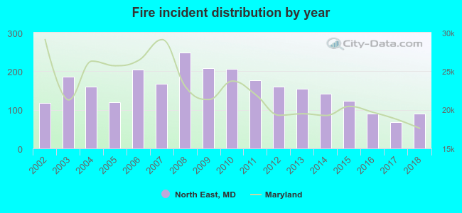 Based on the data from the years 2002 - 2018 the average number of fires per year is 155. The highest number of reported fires - 249 took place in 2008, and the least - 69 in 2017. The data has a declining trend.
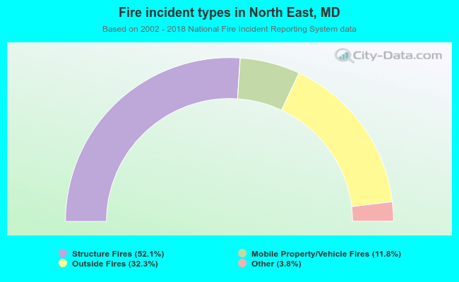 When looking into fire subcategories, the most reports belonged to: Structure Fires (52.1%), and Outside Fires (32.3%).
Fire-safe hotels and motels in North East, Maryland:
- Comfort Inn & Suites, 1 Center Dr, North East, Maryland 21901 , Phone: (410) 287-7100, Fax: (410) 287-7109
- Holiday Inn Express, 101 Hotel Plz, North East, Maryland 21901 , Phone: (410) 287-0008, Fax: (410) 287-7722
- Best Western North East Inn, 39 Elwoods Rd, North East, Maryland 21901 , Phone: (410) 287-5450, Fax: (410) 287-5090
| Most common first names in North East, MD among deceased individuals | ||
| Name | Count | Lived (average) |
|---|---|---|
| Mary | 80 | 78.4 years |
| John | 79 | 72.6 years |
| William | 68 | 74.3 years |
| Charles | 49 | 75.0 years |
| Robert | 48 | 66.9 years |
| James | 45 | 68.3 years |
| George | 38 | 74.4 years |
| Harry | 33 | 78.2 years |
| Helen | 32 | 80.0 years |
| Joseph | 30 | 70.6 years |
| Most common last names in North East, MD among deceased individuals | ||
| Last name | Count | Lived (average) |
|---|---|---|
| Brown | 30 | 68.1 years |
| Smith | 29 | 74.9 years |
| Reynolds | 25 | 75.7 years |
| Johnson | 21 | 71.6 years |
| Miller | 21 | 71.6 years |
| Moore | 19 | 77.1 years |
| Mckinney | 17 | 68.3 years |
| Taylor | 17 | 75.0 years |
| Jones | 17 | 67.6 years |
| Williams | 16 | 69.1 years |
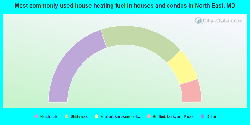
- 39.8%Electricity
- 36.5%Utility gas
- 14.0%Fuel oil, kerosene, etc.
- 9.7%Bottled, tank, or LP gas
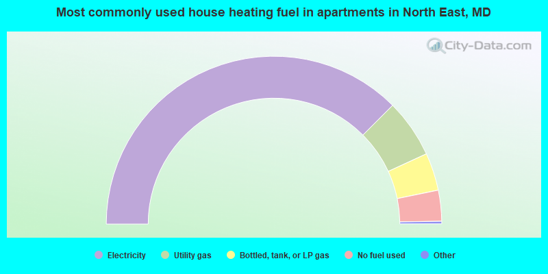
- 75.4%Electricity
- 11.3%Utility gas
- 7.3%Bottled, tank, or LP gas
- 6.0%No fuel used
North East compared to Maryland state average:
- Median house value below state average.
- Unemployed percentage below state average.
- Hispanic race population percentage significantly below state average.
- Foreign-born population percentage significantly below state average.
- House age below state average.
- Number of college students below state average.

|
|
Total of 85 patent applications in 2008-2024.