North Craig, Oklahoma
Submit your own pictures of this place and show them to the world
- OSM Map
- General Map
- Google Map
- MSN Map

| Males: 1,486 | |
| Females: 1,527 |
| Median resident age: | 38.6 years |
| Oklahoma median age: | 35.5 years |
Zip code: 74369
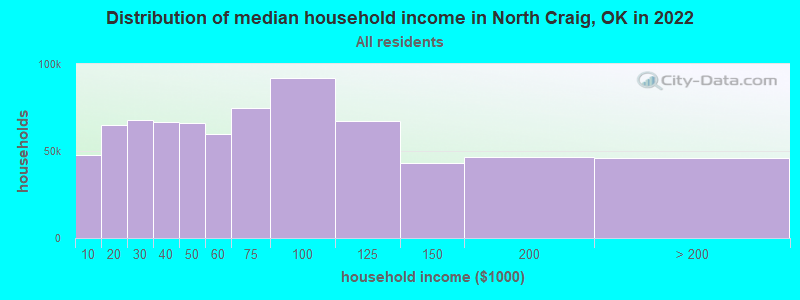
| North Craig: | $47,516 |
| OK: | $59,673 |
Estimated per capita income in 2022: $21,115 (it was $14,738 in 2000)
North Craig CCD income, earnings, and wages data
Estimated median house or condo value in 2022: $131,664 (it was $56,600 in 2000)
| North Craig: | $131,664 |
| OK: | $191,700 |
Mean prices in 2022: all housing units: $204,805; detached houses: $213,237; townhouses or other attached units: $421,025; in 5-or-more-unit structures: $154,934; mobile homes: $81,461; occupied boats, rvs, vans, etc.: $168,953
Detailed information about poverty and poor residents in North Craig, OK
Compare current foreclosures near North Craig, OK:
| Photo | Address | Area | Beds / Baths | Price | Details |
|---|---|---|---|---|---|

|
#1
S Gunter St
Vinita, OK 74301
|
1,311 sq. feet
|
1 baths 2 beds |
$29,900
|
show details |

|
#2
S Central Ave
Afton, OK 74331
|
1,008 sq. feet
|
1 baths 3 beds |
show details | |

|
#3
Oak St
North Miami, OK 74358
|
896 sq. feet
|
1 baths 2 beds |
show details | |

|
#4
Mcbee St
Commerce, OK 74339
|
1,544 sq. feet
|
2 baths 3 beds |
show details | |

|
#5
G St NW
Miami, OK 74354
|
1,122 sq. feet
|
1 baths 2 beds |
show details | |

|
#6
Park Heights St
Miami, OK 74354
|
846 sq. feet
|
1 baths 2 beds |
show details | |

|
#7
5th Ave NW
Miami, OK 74354
|
1,066 sq. feet
|
1 baths 3 beds |
show details | |

|
#8
K St NW
Miami, OK 74354
|
1,271 sq. feet
|
2 baths 3 beds |
show details | |

|
#9
N Elm St
Miami, OK 74354
|
1,366 sq. feet
|
2 baths 3 beds |
show details | |

|
#10
15th Ave NE
Miami, OK 74354
|
1,971 sq. feet
|
2 baths 4 beds |
show details |
| Photo | Address | Area | Beds / Baths | Price | Details |
|---|---|---|---|---|---|

|
#11
H St NE
Miami, OK 74354
|
1,324 sq. feet
|
1 baths 3 beds |
show details | |

|
#12
S 5th St
Chetopa, KS 67336
|
1,408 sq. feet
|
1 baths 2 beds |
show details | |

|
#13
Camelot Pl
Miami, OK 74354
|
2,091 sq. feet
|
1 baths 4 beds |
show details | |

|
#14
15th Ave NE
Miami, OK 74354
|
1,757 sq. feet
|
2 baths 3 beds |
show details | |

|
#15
C St NE
Miami, OK 74354
|
1,320 sq. feet
|
1 baths 3 beds |
show details | |

|
#16
Washington Dr
Miami, OK 74354
|
- sq. feet
|
1 baths 3 beds |
show details | |

|
#17
W Canadian Ave
Vinita, OK 74301
|
- sq. feet
|
- baths - beds |
show details | |

|
#18
N Scraper St
Vinita, OK 74301
|
- sq. feet
|
- baths - beds |
show details | |

|
#19
E 40 Rd
Welch, OK 74369
|
- sq. feet
|
- baths - beds |
show details | |

|
#20
N Elm St Apt 48
Miami, OK 74354
|
- sq. feet
|
- baths - beds |
show details |
| Photo | Address | Area | Beds / Baths | Price | Details |
|---|---|---|---|---|---|

|
#21
S Mickey Mantle Blvd
Commerce, OK 74339
|
- sq. feet
|
- baths - beds |
show details | |

|
#22
B St NW
Miami, OK 74354
|
- sq. feet
|
- baths - beds |
show details | |

|
#23
W Bj Tunnell Blvd
Miami, OK 74354
|
- sq. feet
|
- baths - beds |
show details | |

|
#24
N Elm St
Vinita, OK 74301
|
- sq. feet
|
- baths - beds |
show details | |

|
Check over 1 million property listings on Foreclosure.com!
|
browse all offers | |||

- 2,09170.4%White alone
- 49016.5%American Indian alone
- 35912.1%Two or more races
- 240.8%Hispanic
- 80.3%Black alone
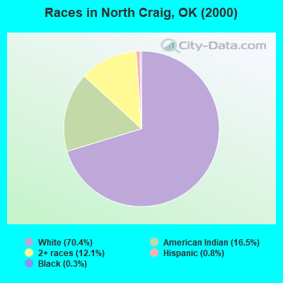
Races in North Craig detailed stats: ancestries, foreign born residents, place of birth
 Recent articles from our blog. Our writers, many of them Ph.D. graduates or candidates, create easy-to-read articles on a wide variety of topics.
Current Local Time: CST time zone
Land area: 333.2 square miles.
Population density: 9.0 people per square mile (very low).

| North Craig CCD: | 0.4% ($228) |
| Oklahoma: | 0.8% ($523) |
Nearest city with pop. 50,000+: Tulsa, OK  (67.8 miles , pop. 393,049).
Nearest city with pop. 1,000,000+: Dallas, TX (297.1 miles , pop. 1,188,580).
Nearest cities:
), ), ), ), Latitude: 36.88 N, Longitude: 95.15 W

| Here: | 3.1% |
| Oklahoma: | 3.2% |
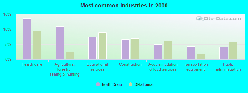
- Health care (13.7%)
- Agriculture, forestry, fishing & hunting (11.0%)
- Educational services (7.5%)
- Construction (6.6%)
- Accommodation & food services (4.9%)
- Transportation equipment (4.3%)
- Public administration (4.2%)
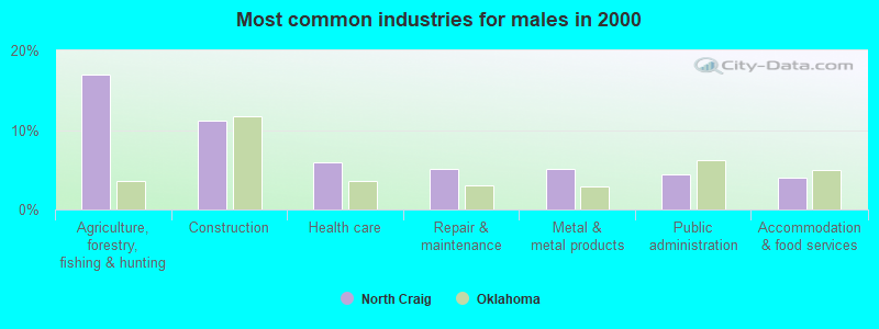
- Agriculture, forestry, fishing & hunting (16.9%)
- Construction (11.1%)
- Health care (6.0%)
- Repair & maintenance (5.1%)
- Metal & metal products (5.1%)
- Public administration (4.4%)
- Accommodation & food services (4.0%)

- Health care (23.3%)
- Educational services (12.1%)
- Accommodation & food services (6.0%)
- Finance & insurance (5.5%)
- Transportation equipment (5.4%)
- Food & beverage stores (5.0%)
- Public administration (4.0%)
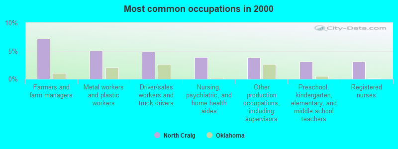
- Farmers and farm managers (7.2%)
- Metal workers and plastic workers (5.0%)
- Driver/sales workers and truck drivers (4.8%)
- Nursing, psychiatric, and home health aides (3.9%)
- Other production occupations, including supervisors (3.8%)
- Preschool, kindergarten, elementary, and middle school teachers (3.1%)
- Registered nurses (3.1%)
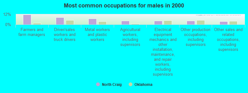
- Farmers and farm managers (11.7%)
- Driver/sales workers and truck drivers (8.2%)
- Metal workers and plastic workers (7.1%)
- Agricultural workers, including supervisors (4.4%)
- Electrical equipment mechanics and other installation, maintenance, and repair workers, including supervisors (4.4%)
- Other production occupations, including supervisors (4.3%)
- Other sales and related occupations, including supervisors (3.5%)
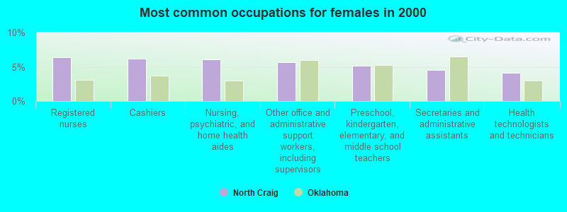
- Registered nurses (6.4%)
- Cashiers (6.2%)
- Nursing, psychiatric, and home health aides (6.0%)
- Other office and administrative support workers, including supervisors (5.7%)
- Preschool, kindergarten, elementary, and middle school teachers (5.2%)
- Secretaries and administrative assistants (4.5%)
- Health technologists and technicians (4.1%)
Average climate in North Craig, Oklahoma
Based on data reported by over 4,000 weather stations


(lower is better)
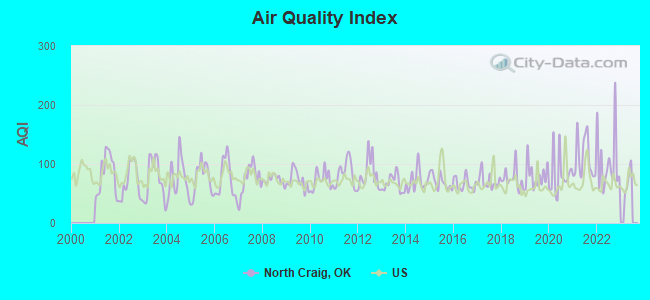
Air Quality Index (AQI) level in 2022 was 103. This is significantly worse than average.
| City: | 103 |
| U.S.: | 73 |
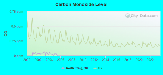
Carbon Monoxide (CO) [ppm] level in 2004 was 0.0242. This is significantly better than average. Closest monitor was 17.4 miles away from the city center.
| City: | 0.0242 |
| U.S.: | 0.2513 |
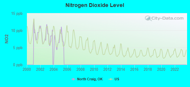
Nitrogen Dioxide (NO2) [ppb] level in 2004 was 6.56. This is worse than average. Closest monitor was 17.4 miles away from the city center.
| City: | 6.56 |
| U.S.: | 5.11 |
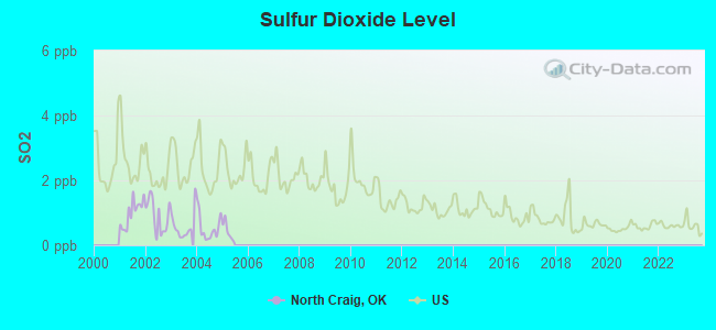
Sulfur Dioxide (SO2) [ppb] level in 2004 was 0.546. This is significantly better than average. Closest monitor was 17.4 miles away from the city center.
| City: | 0.546 |
| U.S.: | 1.515 |
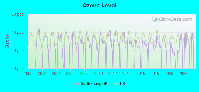
Ozone [ppb] level in 2022 was 31.8. This is about average. Closest monitor was 17.4 miles away from the city center.
| City: | 31.8 |
| U.S.: | 33.3 |
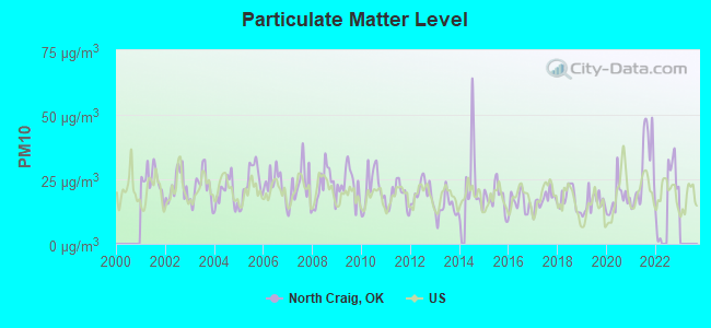
Particulate Matter (PM10) [µg/m3] level in 2022 was 20.7. This is about average. Closest monitor was 17.4 miles away from the city center.
| City: | 20.7 |
| U.S.: | 19.2 |
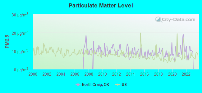
Particulate Matter (PM2.5) [µg/m3] level in 2022 was 9.25. This is about average. Closest monitor was 17.4 miles away from the city center.
| City: | 9.25 |
| U.S.: | 8.11 |
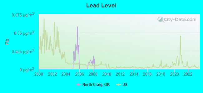
Lead (Pb) [µg/m3] level in 2007 was 0.00938. This is about average. Closest monitor was 15.1 miles away from the city center.
| City: | 0.00938 |
| U.S.: | 0.00931 |
Tornado activity:
North Craig-area historical tornado activity is near Oklahoma state average. It is 127% greater than the overall U.S. average.
On 9/27/1959, a category F4 (max. wind speeds 207-260 mph) tornado 6.0 miles away from the North Craig place center killed one person and injured one person and caused between $5000 and $50,000 in damages.
On 5/10/2008, a category F4 tornado 8.3 miles away from the place center killed 21 people and injured 350 people and caused $61 million in damages.
Earthquake activity:
North Craig-area historical earthquake activity is significantly above Oklahoma state average. It is 714% greater than the overall U.S. average.On 9/3/2016 at 12:02:44, a magnitude 5.8 (5.8 MW, Depth: 3.5 mi, Class: Moderate, Intensity: VI - VII) earthquake occurred 103.7 miles away from North Craig center
On 11/6/2011 at 03:53:10, a magnitude 5.7 (5.7 MW, Depth: 3.2 mi) earthquake occurred 129.7 miles away from North Craig center
On 11/7/2016 at 01:44:24, a magnitude 5.0 (5.0 MW, Depth: 2.8 mi) earthquake occurred 110.7 miles away from the city center
On 11/12/2014 at 21:40:00, a magnitude 4.9 (4.9 MW, Depth: 2.5 mi, Class: Light, Intensity: IV - V) earthquake occurred 139.1 miles away from the city center
On 11/5/2011 at 07:12:45, a magnitude 4.8 (4.8 MW, Depth: 1.9 mi) earthquake occurred 128.8 miles away from the city center
On 11/8/2011 at 02:46:57, a magnitude 4.8 (4.8 MW, Depth: 3.1 mi) earthquake occurred 130.7 miles away from the city center
Magnitude types: moment magnitude (MW)
Natural disasters:
The number of natural disasters in Craig County (25) is a lot greater than the US average (15).Major Disasters (Presidential) Declared: 16
Emergencies Declared: 5
Causes of natural disasters: Floods: 13, Storms: 12, Tornadoes: 11, Winter Storms: 11, Winds: 5, Hurricane: 1, Snowstorm: 1, Other: 1 (Note: some incidents may be assigned to more than one category).
Hospitals and medical centers near North Craig:
- CHETOPA MANOR (Nursing Home, about 12 miles away; CHETOPA, KS)
- CHETOPA NH (Nursing Home, about 12 miles away; CHETOPA, KS)
- HOPE HOUSING OAKCREST HOUSE (Hospital, about 15 miles away; MIAMI, OK)
- HOPE HOUSING K HOUSE (Hospital, about 15 miles away; MIAMI, OK)
- HOPE HOUSING WILSON HOUSE (Hospital, about 15 miles away; MIAMI, OK)
- CARE NURSING CENTER (Nursing Home, about 15 miles away; MIAMI, OK)
- WILLOW CREST HOSPITAL (Hospital, about 15 miles away; MIAMI, OK)
Colleges/universities with over 2000 students nearest to North Craig:
- Northeastern Oklahoma A&M College (about 16 miles; Miami, OK; Full-time enrollment: 2,075)
- Missouri Southern State University (about 41 miles; Joplin, MO; FT enrollment: 4,456)
- Pittsburg State University (about 44 miles; Pittsburg, KS; FT enrollment: 6,838)
- Crowder College (about 44 miles; Neosho, MO; FT enrollment: 3,675)
- Rogers State University (about 48 miles; Claremore, OK; FT enrollment: 3,482)
- John Brown University (about 58 miles; Siloam Springs, AR; FT enrollment: 2,097)
- NorthWest Arkansas Community College (about 66 miles; Bentonville, AR; FT enrollment: 5,634)
Points of interest:
Notable locations in North Craig: Beachner Grain Elevator Number 18 (A), Pyaramid Corners (B), Bluejacket Volunteer Fire Department (C), Welch Volunteer Fire Department (D). Display/hide their locations on the map
Churches in North Craig include: Bethel Church (A), Methodist Church (B), Maybelle Church (C), Sunshine Bible Church (D), Timber Hill Church (E), Timbered Hill Church (F), Wimer Community Church (G). Display/hide their locations on the map
Cemeteries: Walker Cemetery (1), Welch Cemetery (2), Williams Cemetery (3), Bluejacket Cemetery (4), Petitt Cemetery (5), Plainview Cemetery (6), Pleasant Valley Cemetery (7). Display/hide their locations on the map
Reservoir: Dick Melendy Reservoir (A). Display/hide its location on the map
Streams, rivers, and creeks: Whiskey Branch (A), Brush Creek (B), Crow Creek (C), Boggs Branch (D), Russell Creek (E), Wolf Creek (F), Willow Creek (G), McDonald Branch (H), Elm Creek (I). Display/hide their locations on the map
| This place: | 2.5 people |
| Oklahoma: | 2.5 people |
| This place: | 73.6% |
| Whole state: | 66.8% |
| This place: | 4.8% |
| Whole state: | 5.9% |
Likely homosexual households (counted as self-reported same-sex unmarried-partner households)
- Lesbian couples: 0.0% of all households
- Gay men: 0.5% of all households
| This place: | 12.1% |
| Whole state: | 14.7% |
| This place: | 4.7% |
| Whole state: | 6.1% |
4 people in group homes intended for adults in 2010
32 people in nursing homes in 2000
5 people in other noninstitutional group quarters in 2000
For population 15 years and over in North Craig:
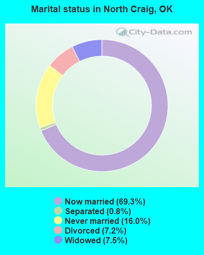
- Never married: 16.0%
- Now married: 69.3%
- Separated: 0.8%
- Widowed: 7.5%
- Divorced: 7.2%
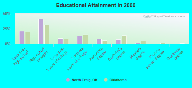
For population 25 years and over in North Craig:
- High school or higher: 79.0%
- Bachelor's degree or higher: 8.7%
- Graduate or professional degree: 1.5%
- Unemployed: 4.0%
- Mean travel time to work (commute): 27.1 minutes
| Here: | 9.2 |
| Oklahoma average: | 11.7 |
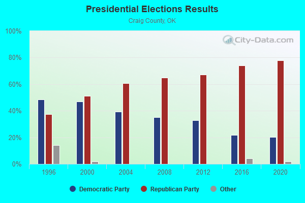
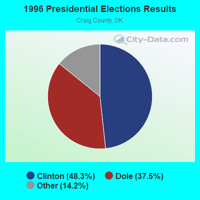
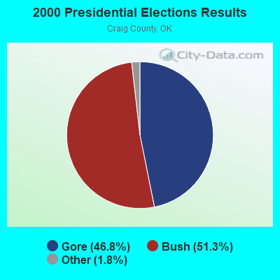
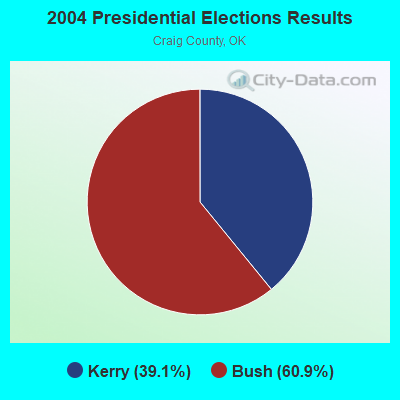
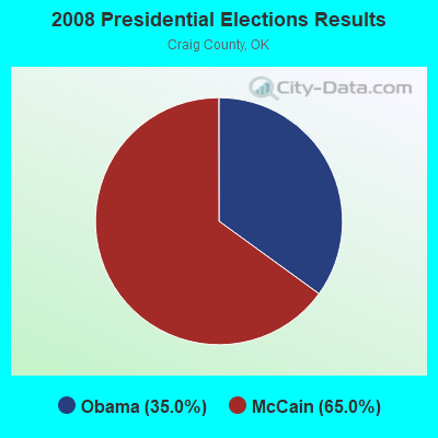
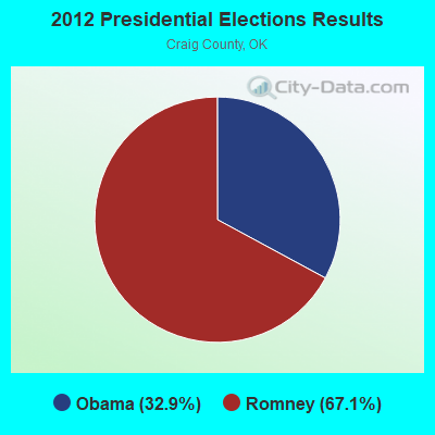
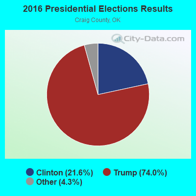
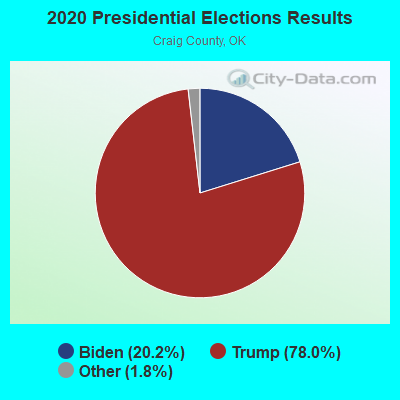
Graphs represent county-level data. Detailed 2008 Election Results
Religion statistics for North Craig, OK (based on Craig County data)
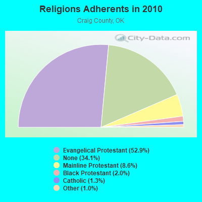
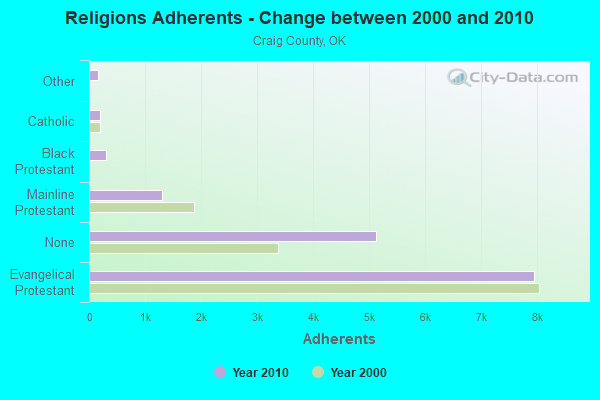
| Religion | Adherents | Congregations |
|---|---|---|
| Evangelical Protestant | 7,952 | 37 |
| Mainline Protestant | 1,300 | 7 |
| Black Protestant | 302 | 2 |
| Catholic | 190 | 2 |
| Other | 156 | 3 |
| None | 5,129 | - |
Food Environment Statistics:
| This county: | 1.98 / 10,000 pop. |
| Oklahoma: | 1.97 / 10,000 pop. |
| Craig County: | 0.66 / 10,000 pop. |
| Oklahoma: | 0.20 / 10,000 pop. |
| Craig County: | 1.98 / 10,000 pop. |
| Oklahoma: | 0.76 / 10,000 pop. |
| Craig County: | 4.62 / 10,000 pop. |
| State: | 4.35 / 10,000 pop. |
| Here: | 8.58 / 10,000 pop. |
| Oklahoma: | 6.89 / 10,000 pop. |
| This county: | 12.2% |
| Oklahoma: | 10.3% |
| Craig County: | 31.9% |
| Oklahoma: | 29.2% |
Strongest AM radio stations in North Craig:
- KGGF (690 AM; 10 kW; COFFEYVILLE, KS; Owner: KGGF-KUSN, INC.)
- KFAQ (1170 AM; 50 kW; TULSA, OK; Owner: JOURNAL BROADCAST CORPORATION)
- KRMG (740 AM; 50 kW; TULSA, OK; Owner: CXR HOLDINGS, INC.)
- KKOW (860 AM; 10 kW; PITTSBURG, KS; Owner: AMERICAN MEDIA INVESTMENTS)
- WMBH (1560 AM; 10 kW; JOPLIN, MO)
- KTBZ (1430 AM; 25 kW; TULSA, OK; Owner: CLEAR CHANNEL BROADCASTING LICENSES, INC.)
- KMUS (1380 AM; 20 kW; MUSKOGEE, OK; Owner: ABC, INC.)
- KBTN (1420 AM; 10 kW; NEOSHO, MO; Owner: PETRACOM OF JOPLIN, L.L.C.)
- KOCR (1310 AM; 5 kW; JOPLIN, MO; Owner: OZARK CHRISTIAN COLLEGE)
- KVIS (910 AM; 1 kW; MIAMI, OK; Owner: EAGLE BROADCASTING, INC.)
- WHB (810 AM; 50 kW; KANSAS CITY, MO; Owner: UNION BROADCASTING, INC.)
- KKLL (1100 AM; daytime; 5 kW; WEBB CITY, MO; Owner: NEW LIFE EVANGELISTIC CENTER, INC.)
- KFAY (1030 AM; 10 kW; FARMINGTON, AR; Owner: CUMULUS LICENSING CORP)
Strongest FM radio stations in North Craig:
- KGND (107.5 FM; KETCHUM, OK; Owner: NORTHEAST OKLAHOMA BROADCAST NETWORK)
- KQLL-FM (106.1 FM; OWASSO, OK; Owner: CLEAR CHANNEL BROADCASTING LICENSES, INC.)
- KRPS (89.9 FM; PITTSBURG, KS; Owner: PITTSBURG STATE UNIVERSITY)
- KKOW-FM (96.9 FM; PITTSBURG, KS; Owner: AMERICAN MEDIA INVESTMENTS, INC.)
- KSYN (92.5 FM; JOPLIN, MO; Owner: BIG MACK BROADCASTING, INC.)
- KIXQ (102.5 FM; JOPLIN, MO; Owner: BIG MACK BROADCASTING, INC.)
- KITO-FM (96.1 FM; VINITA, OK; Owner: DLB BROADCASTING CORPORATION)
- KGLC (100.9 FM; MIAMI, OK; Owner: EAGLE BROADCASTING, INC.)
- KGVE (99.3 FM; GROVE, OK; Owner: CALEB CORPORATION)
TV broadcast stations around North Craig:
- KOAM-TV (Channel 7; PITTSBURG, KS; Owner: SAGA QUAD STATES COMMUNICATIONS, LLC)
- KODE-TV (Channel 12; JOPLIN, MO; Owner: MISSION BROADCASTING, INC.)
- KOZJ (Channel 26; JOPLIN, MO; Owner: BD. OF GOVERNORS OF SW MISSOURI STATE UNIVERSITY)
- KDOR (Channel 17; BARTLESVILLE, OK; Owner: TRINITY BROADCASTING NETWORK)
- KJPX-LP (Channel 47; JOPLIN, MO; Owner: GARY M./DEBORAH R. KENNY)
- KSNF (Channel 16; JOPLIN, MO; Owner: NEXSTAR BROADCASTING OF JOPLIN, L.L.C.)
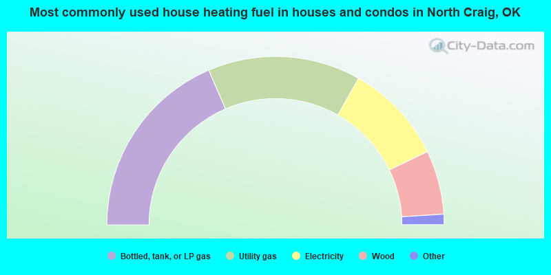
- 37.1%Bottled, tank, or LP gas
- 29.4%Utility gas
- 19.3%Electricity
- 12.3%Wood
- 1.3%Fuel oil, kerosene, etc.
- 0.7%Other fuel

- 36.6%Bottled, tank, or LP gas
- 26.4%Utility gas
- 25.9%Electricity
- 9.3%Wood
- 1.9%Other fuel
North Craig compared to Oklahoma state average:
- Unemployed percentage significantly below state average.
- Black race population percentage significantly below state average.
- Hispanic race population percentage significantly below state average.
- Foreign-born population percentage significantly below state average.
- Renting percentage below state average.
- Length of stay since moving in significantly above state average.
- Number of rooms per house significantly below state average.
- House age significantly below state average.
- Percentage of population with a bachelor's degree or higher below state average.