Newburgh, Maine
Submit your own pictures of this town and show them to the world
- OSM Map
- Google Map
- MSN Map
Population change since 2000: +11.3%
 |
| Males: 784 | |
| Females: 767 |
| Median resident age: | 41.6 years |
| Maine median age: | 43.0 years |
Zip codes: 04444.
| Newburgh: | $71,080 |
| ME: | $69,543 |
Estimated per capita income in 2022: $38,195 (it was $19,000 in 2000)
Newburgh town income, earnings, and wages data
Estimated median house or condo value in 2022: $237,829 (it was $91,400 in 2000)
| Newburgh: | $237,829 |
| ME: | $290,600 |
Mean prices in 2022: all housing units: $235,563; detached houses: $252,705; townhouses or other attached units: $267,749; in 2-unit structures: $255,332; in 3-to-4-unit structures: $815,300; in 5-or-more-unit structures: $185,873; mobile homes: $93,017; occupied boats, rvs, vans, etc.: $21,333
Detailed information about poverty and poor residents in Newburgh, ME


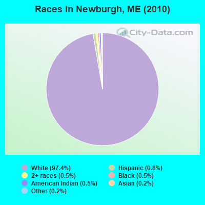
- 1,51097.4%White alone
- 130.8%Hispanic
- 70.5%Black alone
- 70.5%American Indian alone
- 80.5%Two or more races
- 30.2%Asian alone
- 30.2%Other race alone
Races in Newburgh detailed stats: ancestries, foreign born residents, place of birth
According to our research of Maine and other state lists, there were 4 registered sex offenders living in Newburgh, Maine as of May 08, 2024.
The ratio of all residents to sex offenders in Newburgh is 388 to 1.
 Recent articles from our blog. Our writers, many of them Ph.D. graduates or candidates, create easy-to-read articles on a wide variety of topics.
Ancestries: English (21.2%), French (11.4%), Irish (11.0%), United States (10.8%), Scottish (5.1%), French Canadian (4.7%).
Current Local Time: EST time zone
Incorporated on 02/15/1819
Land area: 30.9 square miles.
Population density: 50 people per square mile (very low).
21 residents are foreign born
| This town: | 1.5% |
| Maine: | 2.9% |
| Newburgh town: | 1.3% ($1,228) |
| Maine: | 1.5% ($1,417) |
Nearest city with pop. 50,000+: Portland, ME  (96.2 miles , pop. 64,249).
Nearest city with pop. 200,000+: Boston, MA (196.1 miles , pop. 589,141).
Nearest city with pop. 1,000,000+: Bronx, NY (364.4 miles , pop. 1,332,650).
Nearest cities:
), ), ), Latitude: 44.72 N, Longitude: 69.00 W
Area code: 207
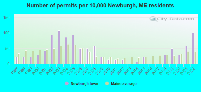
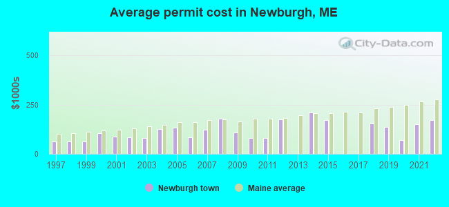
Single-family new house construction building permits:
- 2022: 14 buildings, average cost: $172,800
- 2021: 8 buildings, average cost: $150,000
- 2020: 4 buildings, average cost: $70,000
- 2019: 7 buildings, average cost: $135,700
- 2018: 4 buildings, average cost: $153,700
- 2015: 3 buildings, average cost: $173,300
- 2014: 1 building, cost: $211,200
- 2012: 2 buildings, average cost: $175,000
- 2011: 2 buildings, average cost: $80,000
- 2010: 2 buildings, average cost: $80,000
- 2009: 3 buildings, average cost: $108,300
- 2008: 8 buildings, average cost: $178,100
- 2007: 7 buildings, average cost: $122,100
- 2006: 7 buildings, average cost: $84,400
- 2005: 13 buildings, average cost: $133,600
- 2004: 12 buildings, average cost: $128,300
- 2003: 15 buildings, average cost: $81,500
- 2002: 13 buildings, average cost: $83,800
- 2001: 6 buildings, average cost: $89,200
- 2000: 4 buildings, average cost: $104,800
- 1999: 3 buildings, average cost: $64,000
- 1998: 3 buildings, average cost: $64,000
- 1997: 3 buildings, average cost: $64,000
| Here: | 3.2% |
| Maine: | 3.4% |


- Health care (11.7%)
- Construction (9.7%)
- Educational services (6.7%)
- Finance & insurance (5.0%)
- Agriculture, forestry, fishing & hunting (4.2%)
- Public administration (4.0%)
- Accommodation & food services (3.8%)

- Construction (16.7%)
- Truck transportation (5.9%)
- Agriculture, forestry, fishing & hunting (5.7%)
- Public administration (5.7%)
- Health care (4.9%)
- Educational services (4.4%)
- Motor vehicle & parts dealers (3.7%)
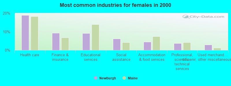
- Health care (19.0%)
- Finance & insurance (9.4%)
- Educational services (9.1%)
- Social assistance (6.1%)
- Accommodation & food services (4.5%)
- Professional, scientific, technical services (3.7%)
- Used merchandise, gift, novelty, souvenir, other miscellaneous stores (2.9%)

- Other management occupations, except farmers and farm managers (4.5%)
- Retail sales workers, except cashiers (4.0%)
- Material recording, scheduling, dispatching, and distributing workers (3.7%)
- Customer service representatives (3.7%)
- Other office and administrative support workers, including supervisors (3.7%)
- Other production occupations, including supervisors (3.6%)
- Other sales and related occupations, including supervisors (3.5%)

- Driver/sales workers and truck drivers (6.6%)
- Vehicle and mobile equipment mechanics, installers, and repairers (5.4%)
- Other production occupations, including supervisors (4.7%)
- Electrical equipment mechanics and other installation, maintenance, and repair workers, including supervisors (4.7%)
- Other management occupations, except farmers and farm managers (4.4%)
- Material recording, scheduling, dispatching, and distributing workers (4.4%)
- Sales representatives, services, wholesale and manufacturing (4.4%)

- Secretaries and administrative assistants (6.4%)
- Other office and administrative support workers, including supervisors (6.1%)
- Customer service representatives (5.9%)
- Preschool, kindergarten, elementary, and middle school teachers (5.1%)
- Retail sales workers, except cashiers (5.1%)
- Information and record clerks, except customer service representatives (5.1%)
- Other management occupations, except farmers and farm managers (4.5%)
Average climate in Newburgh, Maine
Based on data reported by over 4,000 weather stations


(lower is better)
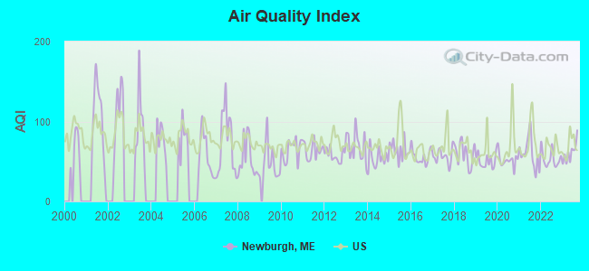
Air Quality Index (AQI) level in 2023 was 61.1. This is about average.
| City: | 61.1 |
| U.S.: | 72.6 |
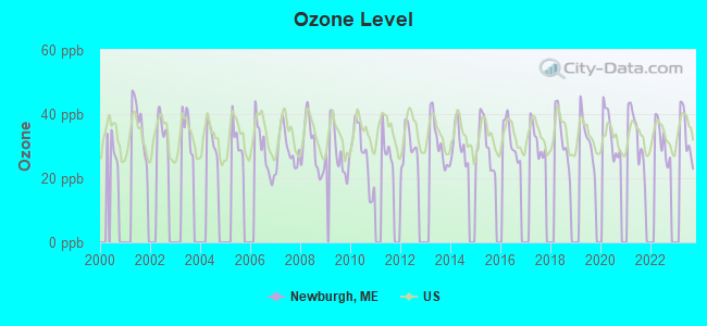
Ozone [ppb] level in 2023 was 33.6. This is about average. Closest monitor was 1.4 miles away from the city center.
| City: | 33.6 |
| U.S.: | 33.3 |
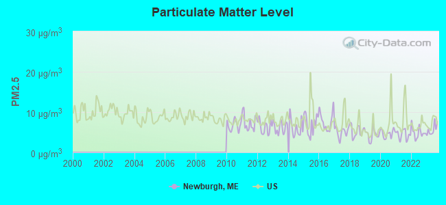
Particulate Matter (PM2.5) [µg/m3] level in 2023 was 5.62. This is significantly better than average. Closest monitor was 12.6 miles away from the city center.
| City: | 5.62 |
| U.S.: | 8.11 |
Earthquake activity:
Newburgh-area historical earthquake activity is significantly above Maine state average. It is 79% smaller than the overall U.S. average.On 4/20/2002 at 10:50:47, a magnitude 5.3 (5.3 ML, Depth: 3.0 mi, Class: Moderate, Intensity: VI - VII) earthquake occurred 231.7 miles away from Newburgh center
On 10/16/2012 at 23:12:25, a magnitude 4.7 (4.7 ML, Depth: 10.0 mi, Class: Light, Intensity: IV - V) earthquake occurred 113.0 miles away from the city center
On 4/20/2002 at 10:50:47, a magnitude 5.2 (5.2 MB, 4.2 MS, 5.2 MW, 5.0 MW) earthquake occurred 232.9 miles away from Newburgh center
On 10/7/1983 at 10:18:46, a magnitude 5.3 (5.1 MB, 5.3 LG, 5.1 ML) earthquake occurred 269.5 miles away from the city center
On 1/19/1982 at 00:14:42, a magnitude 4.7 (4.5 MB, 4.7 MD, 4.5 LG) earthquake occurred 154.2 miles away from the city center
On 2/26/1999 at 03:38:43, a magnitude 3.8 (3.8 LG, Depth: 2.0 mi, Class: Light, Intensity: II - III) earthquake occurred 30.4 miles away from Newburgh center
Magnitude types: regional Lg-wave magnitude (LG), body-wave magnitude (MB), duration magnitude (MD), local magnitude (ML), surface-wave magnitude (MS), moment magnitude (MW)
Natural disasters:
The number of natural disasters in Penobscot County (19) is greater than the US average (15).Major Disasters (Presidential) Declared: 11
Emergencies Declared: 7
Causes of natural disasters: Floods: 9, Storms: 8, Snows: 5, Heavy Rains: 2, Blizzard: 1, Hurricane: 1, Ice Storm: 1, Snowfall: 1, Wind: 1, Winter Storm: 1, Other: 2 (Note: some incidents may be assigned to more than one category).
Hospitals and medical centers near Newburgh:
- BANGOR NURSING AND REHABILITATION (Nursing Home, about 12 miles away; BANGOR, ME)
- ST JOSEPH HOSPICE (Hospital, about 12 miles away; BANGOR, ME)
- ST JOSEPH HOSPITAL Acute Care Hospitals (about 12 miles away; BANGOR, ME)
- BANGOR AREA VISITING NURSES (Home Health Center, about 12 miles away; BANGOR, ME)
- HOSPICE OF EASTERN MAINE (Hospital, about 12 miles away; BANGOR, ME)
- KINDRED NURSING AND REHABILITATION-WESTGATE (Nursing Home, about 12 miles away; BANGOR, ME)
- AMEDISYS HOME HEALTH OF BANGOR (Home Health Center, about 13 miles away; BANGOR, ME)
Airports located in Newburgh:
- Miller's Field Airport (ME74) (Runways: 1)
Colleges/universities with over 2000 students nearest to Newburgh:
- Husson University (about 13 miles; Bangor, ME; Full-time enrollment: 2,421)
- University of Maine (about 21 miles; Orono, ME; FT enrollment: 8,931)
- University of Maine at Augusta (about 48 miles; Augusta, ME; FT enrollment: 3,204)
- University of Maine at Farmington (about 57 miles; Farmington, ME; FT enrollment: 2,036)
- Southern Maine Community College (about 96 miles; South Portland, ME; FT enrollment: 4,666)
- Saint Joseph's College of Maine (about 96 miles; Standish, ME; FT enrollment: 2,010)
- University of Southern Maine (about 97 miles; Portland, ME; FT enrollment: 6,647)
Public school in Newburgh:
- NEWBURGH ELEMENTARY SCHOOL (Location: 2220 WESTERN AVENUE, Grades: PK)
Points of interest:
Notable locations in Newburgh: Newburgh Volunteer Fire Department Station 2 (A), Newburgh Volunteer Fire Department Station 1 (B). Display/hide their locations on the map
Cemeteries: Rogers Cemetery (1), Lufkin Cemetery (2), Leavitt Cemetery (3), Bickford Cemetery (4), Graveyard Cemetery (5), Chapman Cemetery (6), Knowlton Cemetery (7). Display/hide their locations on the map
Lakes and swamps: Chapman Pond (A), Gilmore Meadows (B), Burnt Swamp (C). Display/hide their locations on the map
Streams, rivers, and creeks: Thurlow Brook (A), Jordan Brook (B). Display/hide their locations on the map
Birthplace of: Ricky Craven - Craftsman Truck series NASCAR driver (born: May 24, 1966).
| This town: | 2.5 people |
| Maine: | 2.3 people |
| This town: | 71.7% |
| Whole state: | 62.9% |
| This town: | 9.3% |
| Whole state: | 9.4% |
Likely homosexual households (counted as self-reported same-sex unmarried-partner households)
- Lesbian couples: 0.8% of all households
- Gay men: 0.0% of all households
| This town: | 5.9% |
| Whole state: | 10.9% |
| This town: | 2.2% |
| Whole state: | 4.1% |
For population 15 years and over in Newburgh:
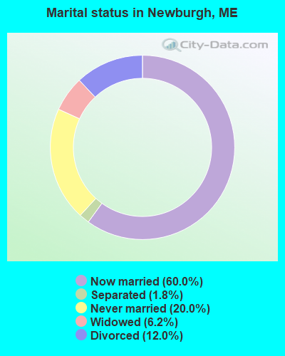
- Never married: 20.0%
- Now married: 60.0%
- Separated: 1.8%
- Widowed: 6.2%
- Divorced: 12.0%
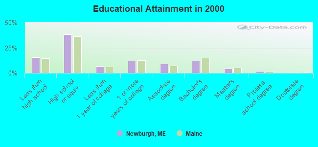
For population 25 years and over in Newburgh:
- High school or higher: 84.5%
- Bachelor's degree or higher: 18.2%
- Graduate or professional degree: 6.2%
- Unemployed: 2.0%
- Mean travel time to work (commute): 25.2 minutes
| Here: | 10.4 |
| Maine average: | 11.2 |


Graphs represent county-level data. Detailed 2008 Election Results
Religion statistics for Newburgh, ME (based on Penobscot County data)


| Religion | Adherents | Congregations |
|---|---|---|
| Catholic | 16,581 | 15 |
| Mainline Protestant | 9,715 | 59 |
| Evangelical Protestant | 7,523 | 80 |
| Other | 2,936 | 22 |
| Orthodox | 300 | 1 |
| None | 116,868 | - |
Food Environment Statistics:
| Here: | 2.29 / 10,000 pop. |
| Maine: | 2.80 / 10,000 pop. |
| Penobscot County: | 0.13 / 10,000 pop. |
| State: | 0.14 / 10,000 pop. |
| Penobscot County: | 2.56 / 10,000 pop. |
| Maine: | 2.20 / 10,000 pop. |
| Penobscot County: | 5.72 / 10,000 pop. |
| Maine: | 5.75 / 10,000 pop. |
| Here: | 7.41 / 10,000 pop. |
| Maine: | 11.02 / 10,000 pop. |
| Penobscot County: | 9.0% |
| Maine: | 8.2% |
| Penobscot County: | 28.0% |
| Maine: | 25.0% |
Strongest AM radio stations in Newburgh:
- WZON (620 AM; 5 kW; BANGOR, ME; Owner: THE ZONE CORPORATION)
- WABI (910 AM; 5 kW; BANGOR, ME; Owner: CLEAR CHANNEL BROADCASTING LICENSES, INC.)
- WSKW (1160 AM; 10 kW; SKOWHEGAN, ME; Owner: MOUNTAIN WIRELESS, INCORPORATED)
- WDEA (1370 AM; 5 kW; ELLSWORTH, ME; Owner: CUMULUS LICENSING CORP.)
- WNZS (1340 AM; 1 kW; VEAZIE, ME; Owner: WATERFRONT COMMUNICATIONS INC.)
- WTME (780 AM; 10 kW; RUMFORD, ME; Owner: MOUNTAIN VALLEY BROADCASTING, INC.)
- WRKO (680 AM; 50 kW; BOSTON, MA; Owner: ENTERCOM BOSTON LICENSE, LLC)
- WFAU (1280 AM; 5 kW; GARDINER, ME; Owner: CAPSTAR TX LIMITED PARTNERSHIP)
- WEEI (850 AM; 50 kW; BOSTON, MA; Owner: ENTERCOM BOSTON LICENSE, LLC)
- WBZ (1030 AM; 50 kW; BOSTON, MA; Owner: INFINITY BROADCASTING OPERATIONS, INC.)
- WCRN (830 AM; 50 kW; WORCESTER, MA; Owner: CARTER BROADCASTING CORPORATION)
- WNNZ (640 AM; 50 kW; WESTFIELD, MA; Owner: CLEAR CHANNEL BROADCASTING LICENSES, INC.)
- WMTW (870 AM; 10 kW; GORHAM, ME; Owner: RADIO PARTNERS OF MAINE, L.P.)
Strongest FM radio stations in Newburgh:
- WWBX (97.1 FM; BANGOR, ME; Owner: CLEAR CHANNEL BROADCASTING LICENSES, INC.)
- WBFB (104.7 FM; BELFAST, ME; Owner: CLEAR CHANNEL BROADCASTING LICENSES, INC.)
- WKIT-FM (100.3 FM; BREWER, ME; Owner: THE ZONE CORPORATION)
- WWMJ (95.7 FM; ELLSWORTH, ME; Owner: CUMULUS LICENSING CORP.)
- WFZX (101.7 FM; SEARSPORT, ME; Owner: CLEAR CHANNEL BROADCASTING LICENSES, INC.)
- WQCB (106.5 FM; BREWER, ME; Owner: CUMULUS LICENSING CORP.)
- WMEH (90.9 FM; BANGOR, ME; Owner: MAINE PUBLIC BROADCASTING CORPORATION)
- WEZQ (92.9 FM; BANGOR, ME; Owner: CUMULUS LICENSING CORP.)
- WVOM (103.9 FM; HOWLAND, ME; Owner: CLEAR CHANNEL BROADCASTING LICENSES, INC.)
- WHCF (88.5 FM; BANGOR, ME; Owner: BANGOR BAPTIST CHURCH)
- WERU-FM (89.9 FM; BLUE HILL, ME; Owner: SALT POND COMMUNITY B/C COMPANY)
- WMEP (90.5 FM; CAMDEN, ME; Owner: MAINE PUBLIC BROADCASTING CORP.)
- WQSS (102.5 FM; CAMDEN, ME; Owner: CLEAR CHANNEL BROADCASTING LICENSES, INC.)
- WGUY (102.1 FM; DEXTER, ME; Owner: CONCORD MEDIA GROUP, INC.)
- WTOS-FM (105.1 FM; SKOWHEGAN, ME; Owner: CAPSTAR TX LIMITED PARTNERSHIP)
- WBZN (107.3 FM; OLD TOWN, ME; Owner: CUMULUS LICENSING CORP.)
- WJCX (99.5 FM; PITTSFIELD, ME; Owner: CSN INTERNATIONAL)
- WCTB (93.5 FM; FAIRFIELD, ME; Owner: MOUNTAIN WIRELESS, INC.)
- WHQO (107.9 FM; SKOWHEGAN, ME; Owner: MOUNTAIN WIRELESS, INC.)
- WWWA (95.3 FM; WINSLOW, ME; Owner: LIGHT OF LIFE MINISTRIES, INC.)
TV broadcast stations around Newburgh:
- WABI-TV (Channel 5; BANGOR, ME; Owner: COMMUNITY BROADCASTING SERVICE)
- W36CK (Channel 36; BANGOR, ME; Owner: TRINITY BROADCASTING NETWORK)
- WCKD-LP (Channel 30; BANGOR/DEDHAM, ME; Owner: J. MCLEOD, ME FAMILY B/CING., INC.)
- WLBZ (Channel 2; BANGOR, ME; Owner: PACIFIC AND SOUTHERN COMPANY, INC.)
- WBGR-LP (Channel 33; BANGOR/DEDHAM, ME; Owner: MAINE FAMILY BROADCASTING, INC.)
- WMEB-TV (Channel 12; ORONO, ME; Owner: MAINE PUBLIC BROADCASTING CORPORATION)
- W66CL (Channel 66; BANGOR, ME; Owner: MS COMMUNICATIONS, LLC)
Newburgh fatal accident list:
Dec 1, 2011 04:14 PM, Littlefield Road, Lat: 44.687058, Lon: -69.006597, Vehicles: 1, Persons: 2, Fatalities: 1
Jul 30, 2007 04:30 PM, Sr-9, Lat: 44.708586, Lon: -69.045408, Vehicles: 2, Persons: 2, Fatalities: 1
- National Bridge Inventory (NBI) Statistics
- 2Number of bridges
- 46ft / 14.2mTotal length
- 3,419Total average daily traffic
- 170Total average daily truck traffic
- 4,862Total future (year 2036) average daily traffic
FCC Registered Broadcast Land Mobile Towers:
1- 2093 Carmel Rd (Lat: 44.731389 Lon: -68.964417), Type: Ltower, Structure height: 51.9 m, Overall height: 57.9 m, Call Sign: WNFV843,
Assigned Frequencies: 151.047 MHz, Grant Date: 03/10/2021, Expiration Date: 04/04/2031, Registrant: Town Of Newburgh, 2220 Western Avenue, Newburgh, ME 04444-4519, Phone: (207) 234-4151, Email:
FCC Registered Amateur Radio Licenses:
13 (See the full list of FCC Registered Amateur Radio Licenses in Newburgh)FAA Registered Aircraft:
5- Aircraft: PIPER PA-11S (Category: Sea, Seats: 2, Weight: Up to 12,499 Pounds, Speed: 67 mph), Engine: CONT MOTOR C90 SERIES (95 HP) (Reciprocating)
N-Number: 4504M, N4504M, N-4504M, Serial Number: 11-7, Year manufactured: 1947, Airworthiness Date: 05/26/1982, Certificate Issue Date: 05/14/2012
Registrant (Individual): John M Miller, 115 North Rd, Newburgh, ME 04444 - Aircraft: CESSNA 150J (Category: Land, Seats: 2, Weight: Up to 12,499 Pounds, Speed: 90 mph), Engine: CONT MOTOR 0-200 SERIES (100 HP) (Reciprocating)
N-Number: 61143, N61143, N-61143, Serial Number: 15070834, Year manufactured: 1969, Airworthiness Date: 06/02/1969, Certificate Issue Date: 10/26/1984
Registrant (Individual): Wesley H Hedlund, 2865 Kennebec Rd, Newburgh, ME 04444 - Aircraft: BEECH V35A (Category: Land, Seats: 6, Weight: Up to 12,499 Pounds, Speed: 150 mph), Engine: CONT MOTOR IO 520 SERIES (285 HP) (Reciprocating)
N-Number: 7694N, N7694N, N-7694N, Serial Number: D-8869, Year manufactured: 1968, Airworthiness Date: 09/26/1968, Certificate Issue Date: 10/13/2010
Registrant (Partnership): Dennis M Bradley, 57 Kimball Rd, Newburgh, ME 04444, Other Owners: Doreen M Bradley - Aircraft: PIPER PA-11 (Category: Land, Seats: 2, Weight: Up to 12,499 Pounds, Speed: 67 mph), Engine: LYCOMING 0-235 SERIES (115 HP) (Reciprocating)
N-Number: 98197, N98197, N-98197, Serial Number: 18358, Year manufactured: 1946, Airworthiness Date: 07/15/1959, Certificate Issue Date: 04/30/2019
Registrant (Individual): Gene E Veinote, 2095 Kennebec Rd, Newburgh, ME 04444 - Aircraft: PIPER J-3C (Category: Land, Seats: 2, Weight: Up to 12,499 Pounds, Speed: 54 mph), Engine: CONT MOTOR A&C65 SERIES (65 HP) (Reciprocating)
N-Number: 98294, N98294, N-98294, Serial Number: 18671, Year manufactured: 1946, Airworthiness Date: 06/13/1956, Certificate Issue Date: 12/03/2008
Registrant (Individual): Gene E Veinote, 2095 Kennebec Rd, Newburgh, ME 04444
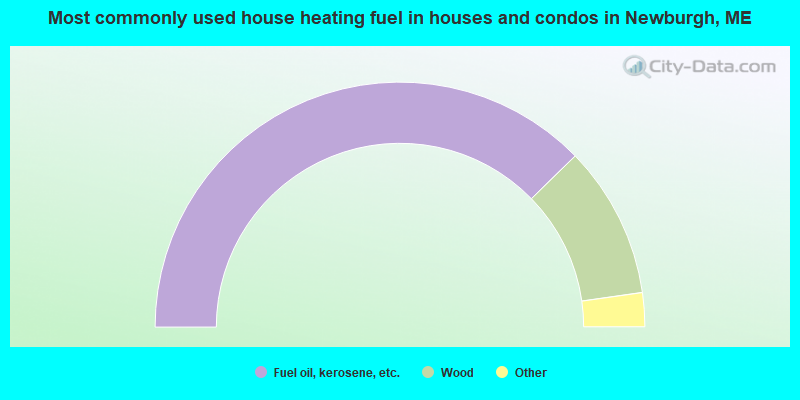
- 75.4%Fuel oil, kerosene, etc.
- 20.1%Wood
- 3.2%Electricity
- 1.3%Bottled, tank, or LP gas
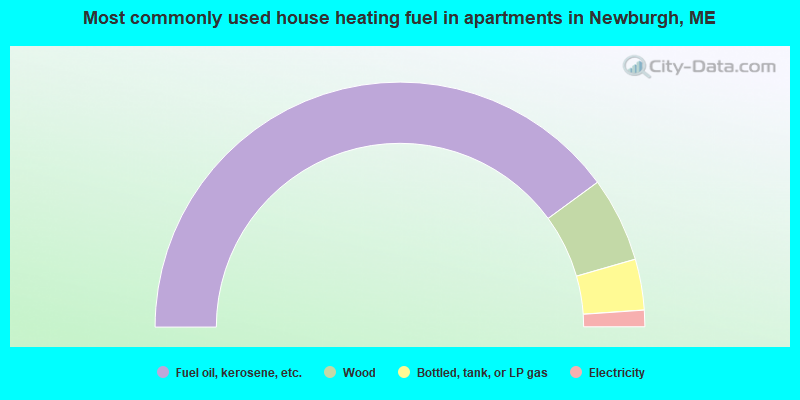
- 79.8%Fuel oil, kerosene, etc.
- 11.2%Wood
- 6.7%Bottled, tank, or LP gas
- 2.2%Electricity
Newburgh compared to Maine state average:
- Unemployed percentage significantly below state average.
- Black race population percentage significantly below state average.
- Hispanic race population percentage below state average.
- Foreign-born population percentage significantly below state average.
- Renting percentage below state average.
- Length of stay since moving in significantly above state average.
- Number of rooms per house significantly below state average.
- House age significantly below state average.