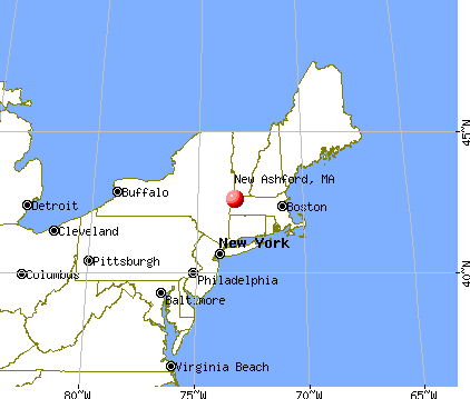
New Ashford, Massachusetts
Submit your own pictures of this town and show them to the world
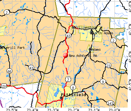
- OSM Map
- General Map
- Google Map
- MSN Map
Population change since 2000: -7.7%
 |
| Males: 120 | |
| Females: 108 |
| Median resident age: | 47.0 years |
| Massachusetts median age: | 39.2 years |
Zip codes: 01237.
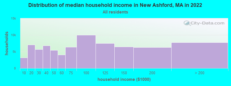
| New Ashford: | $97,358 |
| MA: | $94,488 |
Estimated per capita income in 2022: $63,528 (it was $28,323 in 2000)
New Ashford town income, earnings, and wages data
Estimated median house or condo value in 2022: $423,860 (it was $158,500 in 2000)
| New Ashford: | $423,860 |
| MA: | $534,700 |
Mean prices in 2022: all housing units: $357,971; detached houses: $376,086; townhouses or other attached units: $341,816; in 2-unit structures: $250,940; in 3-to-4-unit structures: $400,871; in 5-or-more-unit structures: $281,990; mobile homes: $80,872

Compare current foreclosures near New Ashford, MA:
| Photo | Address | Area | Beds / Baths | Price | Details |
|---|---|---|---|---|---|

|
#1
Elmwood Ave
North Adams, MA 01247
|
2,777 sq. feet
|
3 baths 5 beds |
$215,000
|
show details |

|
#2
Arnold Ct
Cheshire, MA 01225
|
1,600 sq. feet
|
2 baths 2 beds |
show details | |

|
#3
Wilshire Dr
Cheshire, MA 01225
|
4,302 sq. feet
|
2 baths 3 beds |
show details | |

|
#4
North St
North Adams, MA 01247
|
1,164 sq. feet
|
1 baths 3 beds |
show details | |

|
#5
Houghton St
North Adams, MA 01247
|
1,614 sq. feet
|
2 baths 4 beds |
show details | |

|
#6
Franklin St
North Adams, MA 01247
|
1,386 sq. feet
|
1 baths 3 beds |
show details | |

|
#7
Grove St
Adams, MA 01220
|
2,644 sq. feet
|
2 baths 7 beds |
show details | |

|
#8
W Mountain Rd
Adams, MA 01220
|
1,173 sq. feet
|
1 baths 3 beds |
show details | |

|
#9
Briggs Ave
Pittsfield, MA 01201
|
2,116 sq. feet
|
2 baths 4 beds |
show details | |

|
#10
Mcarthur St
Pittsfield, MA 01201
|
1,155 sq. feet
|
1 baths 2 beds |
show details |
| Photo | Address | Area | Beds / Baths | Price | Details |
|---|---|---|---|---|---|

|
#11
Crystal St
Pittsfield, MA 01201
|
1,282 sq. feet
|
1 baths 3 beds |
show details | |

|
#12
Longfellow Ave
Pittsfield, MA 01201
|
1,356 sq. feet
|
1 baths 4 beds |
show details | |

|
#13
Daniels Ave
Pittsfield, MA 01201
|
1,172 sq. feet
|
1 baths 3 beds |
show details | |

|
#14
Lenox Ave
Pittsfield, MA 01201
|
2,290 sq. feet
|
2 baths 6 beds |
show details | |

|
#15
Summit Ave
Pittsfield, MA 01201
|
1,664 sq. feet
|
2 baths 4 beds |
show details | |

|
#16
Phelps Rd
North Adams, MA 01247
|
1,286 sq. feet
|
1 baths 4 beds |
show details | |

|
#17
North St
Dalton, MA 01226
|
1,852 sq. feet
|
2 baths 4 beds |
show details | |

|
#18
Imperial Ave
Pittsfield, MA 01201
|
1,326 sq. feet
|
1 baths 3 beds |
show details | |

|
#19
Garfield Ave
Pittsfield, MA 01201
|
2,432 sq. feet
|
2 baths 4 beds |
show details | |

|
#20
West St
Pittsfield, MA 01201
|
1,714 sq. feet
|
1 baths 4 beds |
show details |
| Photo | Address | Area | Beds / Baths | Price | Details |
|---|---|---|---|---|---|

|
#21
Elberon Ave
Pittsfield, MA 01201
|
1,794 sq. feet
|
1 baths 4 beds |
show details | |

|
#22
West St
Pittsfield, MA 01201
|
2,018 sq. feet
|
1 baths 3 beds |
show details | |

|
#23
Fox Way
Petersburg, NY 12138
|
1,734 sq. feet
|
1 baths 1 beds |
show details | |

|
#24
Anita Dr
Pittsfield, MA 01201
|
1,504 sq. feet
|
2 baths 3 beds |
show details | |

|
#25
Legate Hill Rd
Charlemont, MA 01339
|
2,016 sq. feet
|
2 baths 3 beds |
show details | |

|
#26
David Dr
Hinsdale, MA 01235
|
1,664 sq. feet
|
2 baths 3 beds |
show details | |

|
#27
Cranberry Pond Rd
Cropseyville, NY 12052
|
1,152 sq. feet
|
1 baths 2 beds |
show details | |

|
#28
Jennifer St
Lenox, MA 01240
|
1,416 sq. feet
|
1 baths 3 beds |
show details | |

|
#29
Varville Rd
Petersburg, NY 12138
|
1,232 sq. feet
|
1 baths 3 beds |
show details | |

|
#30
Joseph Dr
Pittsfield, MA 01201
|
1,248 sq. feet
|
1 baths 3 beds |
show details |
| Photo | Address | Area | Beds / Baths | Price | Details |
|---|---|---|---|---|---|

|
#31
Donovan St
Pittsfield, MA 01201
|
1,652 sq. feet
|
2 baths 3 beds |
show details | |

|
#32
Kathy Way
Pittsfield, MA 01201
|
2,136 sq. feet
|
2 baths 3 beds |
show details | |

|
#33
E Shore Dr
Petersburg, NY 12138
|
1,000 sq. feet
|
1 baths 6 beds |
show details | |

|
#34
Loop Rd
Savoy, MA 01256
|
1,040 sq. feet
|
1 baths 3 beds |
show details | |

|
#35
Rte 9
Windsor, MA 01270
|
1,223 sq. feet
|
1 baths 2 beds |
show details | |

|
#36
Marshall Ave
Pittsfield, MA 01201
|
1,517 sq. feet
|
1 baths 3 beds |
show details | |

|
#37
Williams St
Pittsfield, MA 01201
|
1,245 sq. feet
|
1 baths 3 beds |
show details | |

|
#38
Hill Hollow Rd
Petersburg, NY 12138
|
980 sq. feet
|
1 baths 1 beds |
show details | |

|
#39
Church Rd
Drury, MA 01343
|
2,560 sq. feet
|
2 baths 4 beds |
show details | |

|
#40
Ashuelot St
Dalton, MA 01226
|
1,792 sq. feet
|
2 baths 3 beds |
show details |
| Photo | Address | Area | Beds / Baths | Price | Details |
|---|---|---|---|---|---|

|
#41
Lenox Ave
Pittsfield, MA 01201
|
1,376 sq. feet
|
1 baths 3 beds |
show details | |

|
#42
Franklin St
North Adams, MA 01247
|
1,386 sq. feet
|
1 baths 3 beds |
show details | |

|
#43
North St
North Adams, MA 01247
|
1,164 sq. feet
|
1 baths 3 beds |
show details | |

|
#44
Valley St
Adams, MA 01220
|
1,680 sq. feet
|
2 baths 4 beds |
show details | |

|
#45
Daniels Ct
Adams, MA 01220
|
1,400 sq. feet
|
1 baths 3 beds |
show details | |

|
#46
Weber St # 12
Adams, MA 01220
|
1,728 sq. feet
|
2 baths 4 beds |
show details | |

|
#47
Richmond St
Adams, MA 01220
|
1,920 sq. feet
|
2 baths 4 beds |
show details | |

|
#48
E Hoosac St
Adams, MA 01220
|
594 sq. feet
|
1 baths 2 beds |
show details | |

|
#49
Anthony St # B
Adams, MA 01220
|
1,622 sq. feet
|
2 baths 3 beds |
show details | |

|
Check over 1 million property listings on Foreclosure.com!
|
browse all offers | |||

- 21493.9%White alone
- 83.5%Two or more races
- 31.3%Asian alone
- 20.9%Black alone
- 10.4%Hispanic
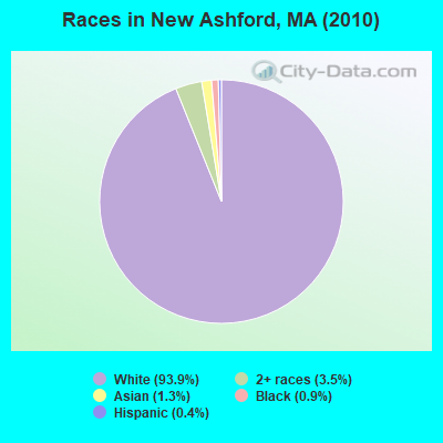
Races in New Ashford detailed stats: ancestries, foreign born residents, place of birth
 Recent articles from our blog. Our writers, many of them Ph.D. graduates or candidates, create easy-to-read articles on a wide variety of topics.


 | Favorite restaurants that are no longer there (478 replies) |
| How Much Massachusetts Households Make Per Year: Census Data (37 replies) |
| affordable retirement communities in mass, so. nh???? (20 replies) |
| Western Mass bear (7 replies) |
Latest news from New Ashford, MA collected exclusively by city-data.com from local newspapers, TV, and radio stations
Ancestries: Irish (23.9%), English (21.9%), French (14.2%), German (13.4%), Italian (12.1%), Scottish (7.7%).
Current Local Time: EST time zone
Incorporated in 1835
Elevation: 1256 feet
Land area: 13.5 square miles.
Population density: 17 people per square mile (very low).
8 residents are foreign born (2.0% Asia, 1.2% Europe).
| This town: | 3.2% |
| Massachusetts: | 12.2% |
| New Ashford town: | 0.4% ($664) |
| Massachusetts: | 1.3% ($2,336) |
Nearest city with pop. 50,000+: Albany, NY  (28.5 miles , pop. 95,658).
Nearest city with pop. 200,000+: Boston, MA (110.8 miles , pop. 589,141).
Nearest city with pop. 1,000,000+: Bronx, NY (126.3 miles , pop. 1,332,650).
Nearest cities:
), ), ), ), )Latitude: 42.61 N, Longitude: 73.23 W
Area code commonly used in this area: 413

Single-family new house construction building permits:
- 2022: 1 building, cost: $350,000
- 2021: 1 building, cost: $350,000
- 2020: 1 building, cost: $350,000
- 2019: 1 building, cost: $350,000
- 2018: 1 building, cost: $350,000
- 2017: 1 building, cost: $350,000
- 2016: 1 building, cost: $350,000
- 2015: 1 building, cost: $350,000
- 2014: 1 building, cost: $350,000
- 2008: 1 building, cost: $264,000
- 2007: 1 building, cost: $972,000
- 2006: 2 buildings, average cost: $145,000
- 2005: 2 buildings, average cost: $173,700
- 2004: 2 buildings, average cost: $85,000
- 2003: 1 building, cost: $126,700
- 2000: 2 buildings, average cost: $112,000
- 1999: 4 buildings, average cost: $206,300
- 1998: 4 buildings, average cost: $180,200
- 1997: 4 buildings, average cost: $180,200
| Here: | 3.8% |
| Massachusetts: | 3.5% |
- Accommodation & food services (20.0%)
- Health care (15.0%)
- Educational services (12.9%)
- Construction (12.1%)
- Arts, entertainment, recreation (5.0%)
- Department & other general merchandise stores (4.3%)
- Publishing, motion picture & sound recording industries (2.9%)
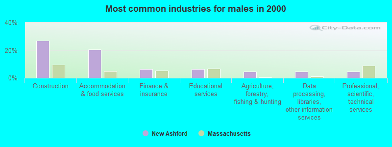
- Construction (27.0%)
- Accommodation & food services (20.6%)
- Finance & insurance (6.3%)
- Educational services (6.3%)
- Agriculture, forestry, fishing & hunting (4.8%)
- Data processing, libraries, other information services (4.8%)
- Professional, scientific, technical services (4.8%)
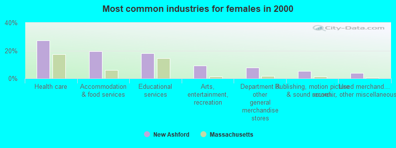
- Health care (27.3%)
- Accommodation & food services (19.5%)
- Educational services (18.2%)
- Arts, entertainment, recreation (9.1%)
- Department & other general merchandise stores (7.8%)
- Publishing, motion picture & sound recording industries (5.2%)
- Used merchandise, gift, novelty, souvenir, other miscellaneous stores (3.9%)
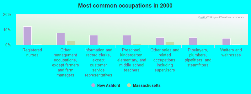
- Registered nurses (12.1%)
- Other management occupations, except farmers and farm managers (7.9%)
- Information and record clerks, except customer service representatives (6.4%)
- Preschool, kindergarten, elementary, and middle school teachers (6.4%)
- Other sales and related occupations, including supervisors (5.0%)
- Pipelayers, plumbers, pipefitters, and steamfitters (5.0%)
- Waiters and waitresses (4.3%)
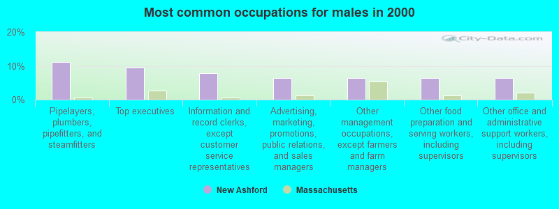
- Pipelayers, plumbers, pipefitters, and steamfitters (11.1%)
- Top executives (9.5%)
- Information and record clerks, except customer service representatives (7.9%)
- Advertising, marketing, promotions, public relations, and sales managers (6.3%)
- Other management occupations, except farmers and farm managers (6.3%)
- Other food preparation and serving workers, including supervisors (6.3%)
- Other office and administrative support workers, including supervisors (6.3%)
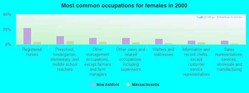
- Registered nurses (22.1%)
- Preschool, kindergarten, elementary, and middle school teachers (11.7%)
- Other management occupations, except farmers and farm managers (9.1%)
- Other sales and related occupations, including supervisors (9.1%)
- Waiters and waitresses (7.8%)
- Information and record clerks, except customer service representatives (5.2%)
- Sales representatives, services, wholesale and manufacturing (5.2%)
Average climate in New Ashford, Massachusetts
Based on data reported by over 4,000 weather stations


(lower is better)
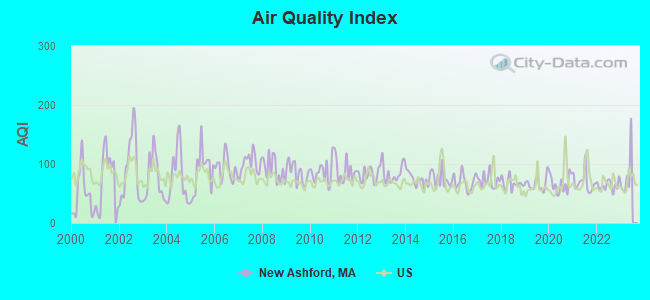
Air Quality Index (AQI) level in 2022 was 63.9. This is about average.
| City: | 63.9 |
| U.S.: | 72.6 |
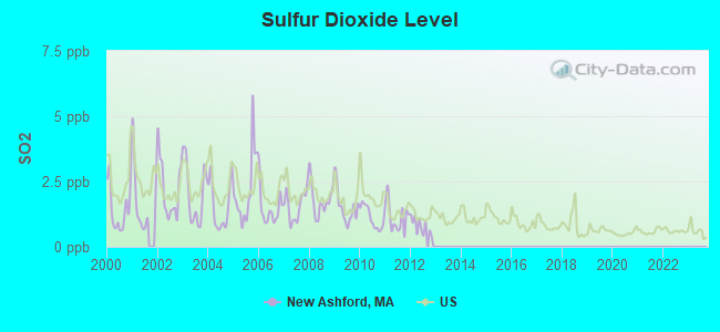
Sulfur Dioxide (SO2) [ppb] level in 2012 was 0.789. This is significantly better than average. Closest monitor was 8.3 miles away from the city center.
| City: | 0.789 |
| U.S.: | 1.515 |
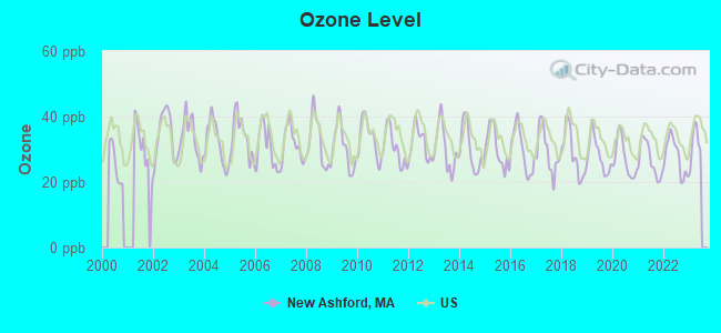
Ozone [ppb] level in 2022 was 27.8. This is about average. Closest monitor was 9.8 miles away from the city center.
| City: | 27.8 |
| U.S.: | 33.3 |
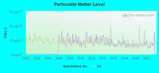
Particulate Matter (PM2.5) [µg/m3] level in 2022 was 6.11. This is better than average. Closest monitor was 8.8 miles away from the city center.
| City: | 6.11 |
| U.S.: | 8.11 |
Tornado activity:
New Ashford-area historical tornado activity is slightly above Massachusetts state average. It is 25% smaller than the overall U.S. average.
On 8/28/1973, a category F4 (max. wind speeds 207-260 mph) tornado 16.3 miles away from the New Ashford town center killed 4 people and injured 36 people and caused between $5,000,000 and $50,000,000 in damages.
On 5/29/1995, a category F4 tornado 30.0 miles away from the town center killed 3 people and injured 24 people and caused between $5,000,000 and $50,000,000 in damages.
Earthquake activity:
New Ashford-area historical earthquake activity is significantly above Massachusetts state average. It is 69% smaller than the overall U.S. average.On 10/7/1983 at 10:18:46, a magnitude 5.3 (5.1 MB, 5.3 LG, 5.1 ML, Class: Moderate, Intensity: VI - VII) earthquake occurred 108.8 miles away from the city center
On 4/20/2002 at 10:50:47, a magnitude 5.3 (5.3 ML, Depth: 3.0 mi) earthquake occurred 133.9 miles away from the city center
On 4/20/2002 at 10:50:47, a magnitude 5.2 (5.2 MB, 4.2 MS, 5.2 MW, 5.0 MW) earthquake occurred 132.4 miles away from New Ashford center
On 1/19/1982 at 00:14:42, a magnitude 4.7 (4.5 MB, 4.7 MD, 4.5 LG, Class: Light, Intensity: IV - V) earthquake occurred 102.8 miles away from New Ashford center
On 10/16/2012 at 23:12:25, a magnitude 4.7 (4.7 ML, Depth: 10.0 mi) earthquake occurred 146.7 miles away from the city center
On 6/17/1991 at 08:53:16, a magnitude 4.1 (4.0 MB, 4.0 LG, Depth: 3.1 mi) earthquake occurred 74.0 miles away from New Ashford center
Magnitude types: regional Lg-wave magnitude (LG), body-wave magnitude (MB), duration magnitude (MD), local magnitude (ML), surface-wave magnitude (MS), moment magnitude (MW)
Natural disasters:
The number of natural disasters in Berkshire County (21) is greater than the US average (15).Major Disasters (Presidential) Declared: 10
Emergencies Declared: 10
Causes of natural disasters: Floods: 5, Snowstorms: 5, Storms: 5, Hurricanes: 4, Winter Storms: 4, Blizzards: 2, Snows: 2, Snowfall: 1, Tropical Storm: 1, Wind: 1, Other: 1 (Note: some incidents may be assigned to more than one category).
Hospitals and medical centers near New Ashford:
- SWEET BROOK OF WILLIAMSTOWN REHABILITATION AND N CTR (Nursing Home, about 5 miles away; WILLIAMSTOWN, MA)
- NORTHERN BERKSHIRE COMPREHENSIVE CARE (Home Health Center, about 7 miles away; ADAMS, MA)
- HOSPICE OF N BERKSHIRE INC (Hospital, about 7 miles away; ADAMS, MA)
- WILLIAMSTOWN COMMONS NURSING AND REHAB (Nursing Home, about 7 miles away; WILLIAMSTOWN, MA)
- NORTH ADAMS REGIONAL HOSPITAL Acute Care Hospitals (about 10 miles away; NORTH ADAMS, MA)
- ADAMS N H OF N ADAMS (Nursing Home, about 10 miles away; NORTH ADAMS, MA)
- NORTH ADAMS COMMONS NURSING AND REHABILITATION CENTE (Nursing Home, about 10 miles away; NORTH ADAMS, MA)
Colleges/universities with over 2000 students nearest to New Ashford:
- Williams College (about 8 miles; Williamstown, MA; Full-time enrollment: 2,141)
- Hudson Valley Community College (about 25 miles; Troy, NY; FT enrollment: 9,346)
- Rensselaer Polytechnic Institute (about 25 miles; Troy, NY; FT enrollment: 6,940)
- The Sage Colleges (about 26 miles; Troy, NY; FT enrollment: 2,499)
- Siena College (about 28 miles; Loudonville, NY; FT enrollment: 3,153)
- The College of Saint Rose (about 29 miles; Albany, NY; FT enrollment: 4,085)
- SUNY at Albany (about 32 miles; Albany, NY; FT enrollment: 15,490)
Points of interest:
Notable locations in New Ashford: Brodie Mountain Ski Area (A), New Ashford Fire Department (B), New Ashford Town Hall (C). Display/hide their locations on the map
Cemetery: New Ashford Cemetery (1). Display/hide its location on the map
Streams, rivers, and creeks: Thompson Brook (A), Mitchell Brook (B), East Branch Green River (C). Display/hide their locations on the map
Park in New Ashford: Mount Greylock State Reservation (1). Display/hide its location on the map
| This town: | 2.4 people |
| Massachusetts: | 2.5 people |
| This town: | 68.4% |
| Whole state: | 63.0% |
| This town: | 11.6% |
| Whole state: | 7.0% |
Likely homosexual households (counted as self-reported same-sex unmarried-partner households)
- Lesbian couples: 1.1% of all households
- Gay men: 1.1% of all households
| This town: | 2.2% |
| Whole state: | 9.3% |
| This town: | 2.2% |
| Whole state: | 4.4% |
For population 15 years and over in New Ashford:
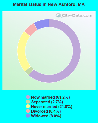
- Never married: 21.8%
- Now married: 61.2%
- Separated: 2.7%
- Widowed: 8.0%
- Divorced: 6.4%
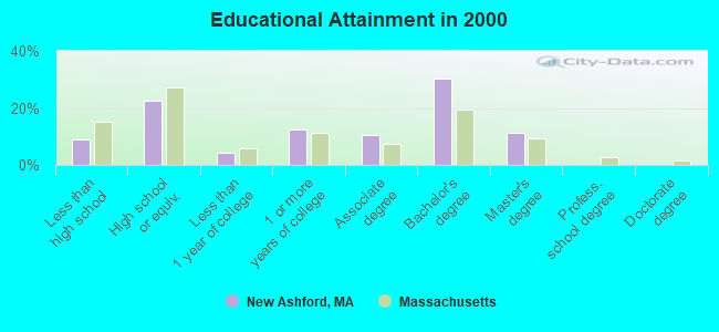
For population 25 years and over in New Ashford:
- High school or higher: 91.1%
- Bachelor's degree or higher: 41.4%
- Graduate or professional degree: 11.2%
- Unemployed: 3.4%
- Mean travel time to work (commute): 19.8 minutes
| Here: | 8.5 |
| Massachusetts average: | 13.1 |


Graphs represent county-level data. Detailed 2008 Election Results
Religion statistics for New Ashford, MA (based on Berkshire County data)


| Religion | Adherents | Congregations |
|---|---|---|
| Catholic | 50,187 | 32 |
| Mainline Protestant | 9,895 | 63 |
| Other | 3,647 | 20 |
| Evangelical Protestant | 2,817 | 28 |
| Black Protestant | 233 | 2 |
| Orthodox | 225 | 2 |
| None | 64,215 | - |
Food Environment Statistics:
| Here: | 2.54 / 10,000 pop. |
| Massachusetts: | 1.98 / 10,000 pop. |
| This county: | 1.61 / 10,000 pop. |
| Massachusetts: | 2.22 / 10,000 pop. |
| Berkshire County: | 4.08 / 10,000 pop. |
| Massachusetts: | 1.77 / 10,000 pop. |
| Berkshire County: | 15.00 / 10,000 pop. |
| Massachusetts: | 8.76 / 10,000 pop. |
| Berkshire County: | 8.0% |
| State: | 8.1% |
| This county: | 22.8% |
| Massachusetts: | 22.5% |
| Berkshire County: | 9.9% |
| Massachusetts: | 16.5% |
Businesses in New Ashford, MA
- Econo Lodge: 1
Strongest AM radio stations in New Ashford:
- WNNZ (640 AM; 50 kW; WESTFIELD, MA; Owner: CLEAR CHANNEL BROADCASTING LICENSES, INC.)
- WGY (810 AM; 50 kW; SCHENECTADY, NY; Owner: CLEAR CHANNEL BROADCASTING LICENSES, INC.)
- WUHN (1110 AM; daytime; 5 kW; PITTSFIELD, MA; Owner: WEINER BROADCASTING, INC.)
- WPTR (1540 AM; 50 kW; ALBANY, NY; Owner: KIMTRON, INC.)
- WNAW (1230 AM; 1 kW; NORTH ADAMS, MA; Owner: BERKSHIRE BROADCASTING CO., INC.)
- WTIC (1080 AM; 50 kW; HARTFORD, CT; Owner: INFINITY RADIO OPERATIONS INC.)
- WCRN (830 AM; 50 kW; WORCESTER, MA; Owner: CARTER BROADCASTING CORPORATION)
- WROW (590 AM; 5 kW; ALBANY, NY; Owner: 6 JOHNSON ROAD LICENSES, INC.)
- WVNE (760 AM; daytime; 25 kW; LEICESTER, MA; Owner: BLOUNT MASSCOM, INC.)
- WIZZ (1520 AM; daytime; 10 kW; GREENFIELD, MA; Owner: P. & M. RADIO, LLC)
- WRKO (680 AM; 50 kW; BOSTON, MA; Owner: ENTERCOM BOSTON LICENSE, LLC)
- WBRK (1340 AM; 1 kW; PITTSFIELD, MA; Owner: WBRK, INC.)
- WTMM (1300 AM; 5 kW; RENSSELAER, NY; Owner: REGENT LICENSEE OF MANSFIELD, INC.)
Strongest FM radio stations in New Ashford:
- WAMC-FM (90.3 FM; ALBANY, NY; Owner: WAMC)
- WZEC (97.5 FM; HOOSICK FALLS, NY; Owner: GREAT NORTHERN RADIO, LLC)
- WMNB (100.1 FM; NORTH ADAMS, MA; Owner: BERKSHIRE BROADCASTING CO., INC.)
- WEQX (102.7 FM; MANCHESTER, VT; Owner: NORTHSHIRE COMMUNICATIONS, INC.)
- WJAN (95.1 FM; SUNDERLAND, VT; Owner: 6 JOHNSON ROAD LICENSES, INC.)
- WBEC-FM (105.5 FM; PITTSFIELD, MA; Owner: GREAT NORTHERN RADIO, LLC)
- WUPE (95.9 FM; PITTSFIELD, MA; Owner: WEINER BROADCASTING, INC.)
- WVAY (100.7 FM; WILMINGTON, VT; Owner: GREAT NORTHERN RADIO, L.L.C.)
- WHVP (91.1 FM; HUDSON, NY; Owner: SOUND OF LIFE, INC.)
- WJJR (98.1 FM; RUTLAND, VT; Owner: 6 JOHNSON ROAD LICENSES, INC.)
- WZRT (97.1 FM; RUTLAND, VT; Owner: CAPSTAR TX LIMITED PARTNERSHIP)
- WAMQ (105.1 FM; GREAT BARRINGTON, MA; Owner: WAMC)
- WAJZ (96.3 FM; VOORHEESVILLE, NY; Owner: 6 JOHNSON ROAD LICENSES, INC.)
- WZMR (104.9 FM; ALTAMONT, NY; Owner: 6 JOHNSON ROAD LICENSES, INC.)
- WPVQ (95.3 FM; GREENFIELD, MA; Owner: GREAT NORTHERN RADIO, L.L.C.)
- WYJB (95.5 FM; ALBANY, NY; Owner: 6 JOHNSON ROAD LICENSES, INC.)
- WHYN-FM (93.1 FM; SPRINGFIELD, MA; Owner: CLEAR CHANNEL BROADCASTING LICENSES, INC.)
- WNGN (91.9 FM; ARGYLE, NY; Owner: NORTHEAST GOSPEL BROADCASTING INC)
- WGNA-FM (107.7 FM; ALBANY, NY; Owner: REGENT LICENSEE OF MANSFIELD, INC.)
- WRSY (101.5 FM; MARLBORO, VT; Owner: GREAT NORTHERN RADIO, L.L.C.)
TV broadcast stations around New Ashford:
- WCDC-TV (Channel 19; ADAMS, MA; Owner: YOUNG BROADCASTING OF ALBANY, INC.)
- W38DL (Channel 38; ADAMS, ETC., MA; Owner: WNYT-TV, LLC)
- WNGN-LP (Channel 26; TROY, NY; Owner: BRIAN A. LARSON)
- W35BK (Channel 35; PLAINFIELD, MA; Owner: LYDIA SYLVANE STOCKWELL)
- National Bridge Inventory (NBI) Statistics
- 4Number of bridges
- 20ft / 5.7mTotal length
- $5,883,000Total costs
- 14,667Total average daily traffic
- 1,459Total average daily truck traffic
- 29,690Total future (year 2032) average daily traffic
FCC Registered Cell Phone Towers:
2 (See the full list of FCC Registered Cell Phone Towers in New Ashford)FCC Registered Antenna Towers:
6 (See the full list of FCC Registered Antenna Towers)FCC Registered Private Land Mobile Towers:
1- Brodie Mountain (Lat: 42.593694 Lon: -73.270389), Type: Tower, Structure height: 27 m, Call Sign: WPTQ864,
Assigned Frequencies: 157.740 MHz, Grant Date: 10/28/2021, Expiration Date: 11/27/2031, Certifier: John Suker, Registrant: Cara Enterprises, Inc, Las Vegas, NV 89140-0124, Phone: (702) 838-9728, Fax: (702) 363-4607, Email:
FCC Registered Broadcast Land Mobile Towers:
1- Rt 7 And Mallory Rd (Lat: 42.604250 Lon: -73.239833), Call Sign: KNDZ332,
Assigned Frequencies: 154.310 MHz, Grant Date: 08/28/2012, Expiration Date: 11/02/2022, Cancellation Date: 01/07/2023, Registrant: Navfd, 4 Ingraham Road, New Ashford, MA 01237, Phone: (413) 458-3850, Email:
FCC Registered Microwave Towers:
1- AL43XC689, 36 Williamstown Rd. (Ma13712-A) (Lat: 42.596306 Lon: -73.252222), Type: Tower, Structure height: 45.7 m, Overall height: 47.5 m, Call Sign: WQPV285,
Assigned Frequencies: 11425.0 MHz, 11425.0 MHz, 11425.0 MHz, Grant Date: 10/12/2022, Expiration Date: 08/22/2032, Cancellation Date: 05/16/2023, Certifier: David Werblow, Registrant: T-Mobile Usa, Inc., 12920 Se 38th Street, Bellevue, WA 98006, Phone: (425) 383-8401, Email:
FCC Registered Amateur Radio Licenses:
2- Call Sign: K1SIF, Licensee ID: L01199990, Grant Date: 10/06/2006, Expiration Date: 12/31/2016, Cancellation Date: 01/01/2019, Certifier: Edward J Le Febvre, Registrant: Edward J Le Febvre, 110 Beach Hill Rd, New Ashford, MA 01237
- Call Sign: N1FGY, Licensee ID: L00294838, Grant Date: 09/22/2020, Expiration Date: 12/11/2030, Certifier: Edmond B Grosso, Registrant: Edmond B Grosso, 70 Route 7, New Ashford, MA 01237
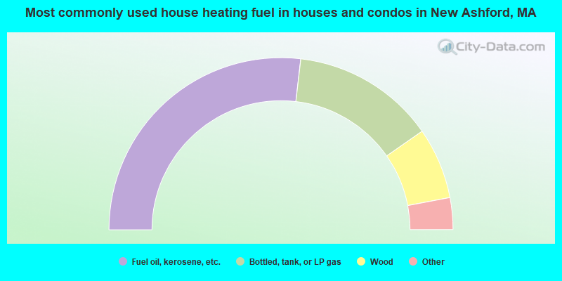
- 53.7%Fuel oil, kerosene, etc.
- 26.9%Bottled, tank, or LP gas
- 13.4%Wood
- 3.0%Electricity
- 3.0%Other fuel
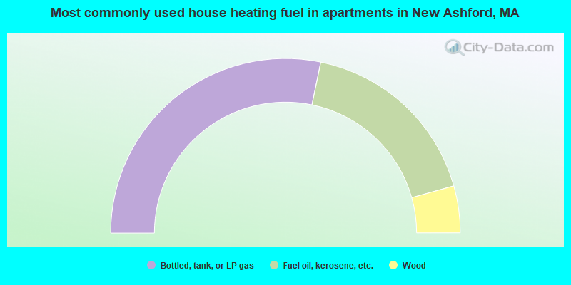
- 56.5%Bottled, tank, or LP gas
- 34.8%Fuel oil, kerosene, etc.
- 8.7%Wood
New Ashford compared to Massachusetts state average:
- Unemployed percentage significantly below state average.
- Black race population percentage significantly below state average.
- Hispanic race population percentage significantly below state average.
- Median age above state average.
- Foreign-born population percentage significantly below state average.
- Renting percentage below state average.
- Length of stay since moving in significantly above state average.
- Number of rooms per house significantly below state average.
- House age significantly below state average.
- Number of college students significantly below state average.