Neva, Tennessee
Submit your own pictures of this place and show them to the world
- OSM Map
- General Map
- Google Map
- MSN Map

| Males: 1,130 | |
| Females: 1,064 |
| Median resident age: | 41.0 years |
| Tennessee median age: | 35.9 years |
Zip code: 37683
| Neva: | $48,880 |
| TN: | $65,254 |
Estimated per capita income in 2022: $26,022 (it was $12,847 in 2000)
Neva CCD income, earnings, and wages data
Estimated median house or condo value in 2022: $164,049 (it was $52,400 in 2000)
| Neva: | $164,049 |
| TN: | $284,800 |
Mean prices in 2022: all housing units: $241,483; detached houses: $274,541; townhouses or other attached units: $93,361; mobile homes: $108,127
Detailed information about poverty and poor residents in Neva, TN


- 2,08397.9%White alone
- 241.1%Hispanic
- 100.5%Two or more races
- 30.1%Black alone
- 30.1%Other race alone
- 20.09%American Indian alone
- 20.09%Asian alone

Races in Neva detailed stats: ancestries, foreign born residents, place of birth
 Recent articles from our blog. Our writers, many of them Ph.D. graduates or candidates, create easy-to-read articles on a wide variety of topics.
Current Local Time: EST time zone
Elevation: 2170 feet
Land area: 65.6 square miles.
Population density: 33 people per square mile (very low).

| Neva CCD: | 0.7% ($351) |
| Tennessee: | 0.8% ($715) |
Nearest city with pop. 50,000+: Johnson City, TN  (26.2 miles , pop. 55,469).
Nearest city with pop. 200,000+: Charlotte, NC (99.4 miles , pop. 540,828).
Nearest city with pop. 1,000,000+: Philadelphia, PA (445.5 miles , pop. 1,517,550).
Nearest cities:
), ), ), Latitude: 36.35 N, Longitude: 81.90 W
Area code commonly used in this area: 423


| Here: | 3.0% |
| Tennessee: | 3.0% |

- Construction (19.4%)
- Accommodation & food services (11.0%)
- Agriculture, forestry, fishing & hunting (6.9%)
- Public administration (6.5%)
- Health care (6.3%)
- Textile mills & textile products (5.5%)
- Educational services (5.2%)

- Construction (33.8%)
- Agriculture, forestry, fishing & hunting (12.5%)
- Textile mills & textile products (8.8%)
- Furniture & related product manufacturing (5.3%)
- Public administration (4.2%)
- Truck transportation (3.9%)
- Religious, grantmaking, civic, professional, similar organizations (3.5%)

- Accommodation & food services (21.1%)
- Health care (12.8%)
- Educational services (9.6%)
- Public administration (9.3%)
- Food & beverage stores (6.4%)
- Religious, grantmaking, civic, professional, similar organizations (5.9%)
- Miscellaneous manufacturing (4.5%)

- Other management occupations, except farmers and farm managers (8.5%)
- Textile, apparel, and furnishings workers (7.8%)
- Cashiers (5.7%)
- Construction traders workers except carpenters, electricians, painters, plumbers, and construction laborers (4.7%)
- Carpenters (4.5%)
- Cooks and food preparation workers (4.2%)
- Building and grounds cleaning and maintenance occupations (4.2%)

- Construction traders workers except carpenters, electricians, painters, plumbers, and construction laborers (8.6%)
- Other management occupations, except farmers and farm managers (8.3%)
- Carpenters (8.1%)
- Farmers and farm managers (7.5%)
- Driver/sales workers and truck drivers (7.2%)
- Textile, apparel, and furnishings workers (6.6%)
- Metal workers and plastic workers (5.7%)

- Cashiers (12.5%)
- Textile, apparel, and furnishings workers (9.3%)
- Other management occupations, except farmers and farm managers (8.8%)
- Cooks and food preparation workers (7.5%)
- Nursing, psychiatric, and home health aides (6.7%)
- Registered nurses (4.8%)
- Other office and administrative support workers, including supervisors (4.8%)
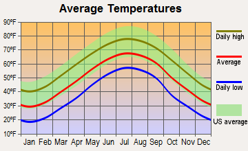
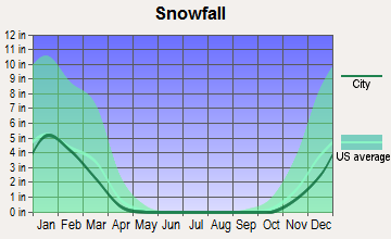
Average climate in Neva, Tennessee
Based on data reported by over 4,000 weather stations


(lower is better)

Air Quality Index (AQI) level in 2021 was 47.6. This is significantly better than average.
| City: | 47.6 |
| U.S.: | 72.6 |

Ozone [ppb] level in 2021 was 37.6. This is about average. Closest monitor was 18.6 miles away from the city center.
| City: | 37.6 |
| U.S.: | 33.3 |


Lead (Pb) [µg/m3] level in 2008 was 0.0520. This is significantly worse than average. Closest monitor was 17.7 miles away from the city center.
| City: | 0.0520 |
| U.S.: | 0.0093 |
Tornado activity:
Neva-area historical tornado activity is significantly below Tennessee state average. It is 63% smaller than the overall U.S. average.
On 5/7/1998, a category F4 (max. wind speeds 207-260 mph) tornado 44.2 miles away from the Neva place center injured 2 people and caused $1 million in damages.
On 7/10/1980, a category F3 (max. wind speeds 158-206 mph) tornado 26.1 miles away from the place center injured 12 people and caused between $50,000 and $500,000 in damages.
Earthquake activity:
Neva-area historical earthquake activity is significantly above Tennessee state average. It is 12% greater than the overall U.S. average.On 8/9/2020 at 12:07:37, a magnitude 5.1 (5.1 MW, Depth: 4.7 mi, Class: Moderate, Intensity: VI - VII) earthquake occurred 45.9 miles away from Neva center
On 8/23/2011 at 17:51:04, a magnitude 5.8 (5.8 MW, Depth: 3.7 mi) earthquake occurred 243.8 miles away from Neva center
On 7/27/1980 at 18:52:21, a magnitude 5.2 (5.1 MB, 4.7 MS, 5.0 UK, 5.2 UK) earthquake occurred 170.5 miles away from the city center
On 11/30/1973 at 07:48:41, a magnitude 4.7 (4.7 MB, 4.6 ML, Class: Light, Intensity: IV - V) earthquake occurred 121.3 miles away from Neva center
On 8/2/1974 at 08:52:09, a magnitude 4.9 (4.3 MB, 4.9 LG) earthquake occurred 174.6 miles away from the city center
On 11/23/2006 at 10:42:57, a magnitude 4.3 (4.3 MB) earthquake occurred 56.0 miles away from the city center
Magnitude types: regional Lg-wave magnitude (LG), body-wave magnitude (MB), local magnitude (ML), surface-wave magnitude (MS), moment magnitude (MW)
Natural disasters:
The number of natural disasters in Johnson County (13) is near the US average (15).Major Disasters (Presidential) Declared: 9
Emergencies Declared: 2
Causes of natural disasters: Floods: 8, Storms: 7, Heavy Rains: 2, Tornadoes: 2, Flash Flood: 1, Hurricane: 1, Landslide: 1, Mudslide: 1, Snowfall: 1, Wind: 1, Winter Storm: 1, Other: 1 (Note: some incidents may be assigned to more than one category).
Hospitals and medical centers near Neva:
- JOHNSON CO HOME HEALTH (Home Health Center, about 10 miles away; MOUNTAIN CITY, TN)
- (CLOSED) JOHNSON COUNTY HEALTH CENTER (Hospital, about 10 miles away; MOUNTAIN CITY, TN)
- JOHNSON COUNTY COMMUNITY HOSPITAL Critical Access Hospitals (about 10 miles away; MOUNTAIN CITY, TN)
- FMC MOUNTAIN CITY (Dialysis Facility, about 10 miles away; MOUNTAIN CITY, TN)
- ADVENTA HOSPICE, INC (Hospital, about 12 miles away; ELIZABETHTON, TN)
- ROAN HIGHLANDS NURSING CENTER (Nursing Home, about 14 miles away; ROAN MOUNTAIN, TN)
Colleges/universities with over 2000 students nearest to Neva:
- Appalachian State University (about 16 miles; Boone, NC; Full-time enrollment: 17,362)
- King University (about 22 miles; Bristol, TN; FT enrollment: 2,472)
- East Tennessee State University (about 27 miles; Johnson City, TN; FT enrollment: 12,774)
- Northeast State Community College (about 30 miles; Blountville, TN; FT enrollment: 4,480)
- Caldwell Community College and Technical Institute (about 42 miles; Hudson, NC; FT enrollment: 3,636)
- Wilkes Community College (about 43 miles; Wilkesboro, NC; FT enrollment: 2,292)
- Western Piedmont Community College (about 46 miles; Morganton, NC; FT enrollment: 2,205)
Points of interest:
Notable locations in Neva: Bakers Gap (A), Gregg Boat Dock (B), Roan Creek Boat Dock (C), Neva Volunteer Fire Department (D), Dry Run Volunteer Fire Department (E). Display/hide their locations on the map
Churches in Neva include: Little Doe Church (A), Sugar Grove Church (B), Baker Gap Church (C), Johnson Chapel (D), Pine Grove Church (E), Pleasant Grove Baptist Church (F), Pleasant View Church (G), Mountain View Church (H), Midway Church (I). Display/hide their locations on the map
Cemeteries: Wagner Cemetery (1), Wolfe Cemetery (2), Laws Cemetery (3), Baker Cemetery (4), Greenwell Cemetery (5), Grindstaff Cemetery (6), Meadows Cemetery (7). Display/hide their locations on the map
Streams, rivers, and creeks: Little Dry Run (A), Lipford Branch (B), Avery Branch (C), Hopper Creek (D), Slimp Branch (E), Stout Branch (F), Vaught Branch (G), West Fork Fall Branch (H), Arnold Branch (I). Display/hide their locations on the map
| This place: | 2.3 people |
| Tennessee: | 2.5 people |
| This place: | 63.9% |
| Whole state: | 69.8% |
| This place: | 4.7% |
| Whole state: | 4.2% |
Likely homosexual households (counted as self-reported same-sex unmarried-partner households)
- Lesbian couples: 0.3% of all households
- Gay men: 0.2% of all households
| This place: | 24.5% |
| Whole state: | 13.5% |
| This place: | 8.0% |
| Whole state: | 5.8% |
For population 15 years and over in Neva:

- Never married: 19.9%
- Now married: 67.4%
- Separated: 1.1%
- Widowed: 7.2%
- Divorced: 5.5%
For population 25 years and over in Neva:
- High school or higher: 57.6%
- Bachelor's degree or higher: 6.2%
- Graduate or professional degree: 1.3%
- Unemployed: 10.7%
- Mean travel time to work (commute): 40.9 minutes


| Here: | 14.1 |
| Tennessee average: | 13.3 |
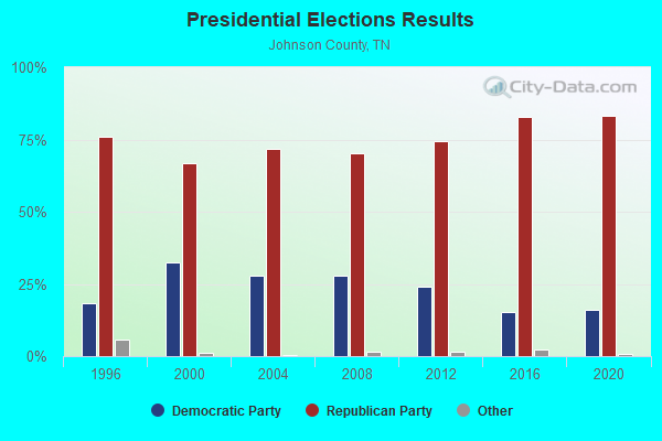
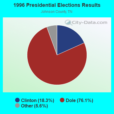


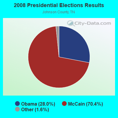
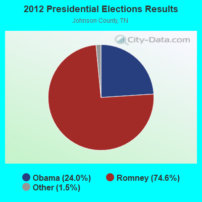


Graphs represent county-level data. Detailed 2008 Election Results
Religion statistics for Neva, TN (based on Johnson County data)
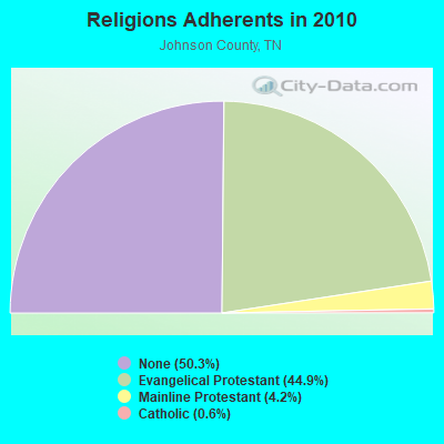
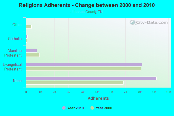
| Religion | Adherents | Congregations |
|---|---|---|
| Evangelical Protestant | 8,183 | 43 |
| Mainline Protestant | 769 | 10 |
| Catholic | 110 | 1 |
| Other | 1 | - |
| None | 9,181 | - |
Food Environment Statistics:
| Johnson County: | 2.76 / 10,000 pop. |
| Tennessee: | 1.99 / 10,000 pop. |
| Johnson County: | 1.11 / 10,000 pop. |
| Tennessee: | 0.65 / 10,000 pop. |
| This county: | 3.32 / 10,000 pop. |
| Tennessee: | 5.16 / 10,000 pop. |
| Johnson County: | 3.32 / 10,000 pop. |
| Tennessee: | 6.56 / 10,000 pop. |
| Johnson County: | 11.8% |
| Tennessee: | 11.4% |
| Johnson County: | 31.8% |
| State: | 30.2% |
| Johnson County: | 15.0% |
| State: | 13.5% |
Strongest AM radio stations in Neva:
- WZAP (690 AM; 10 kW; BRISTOL, VA; Owner: RAM COMMUNICATIONS, INC.)
- WXIT (1200 AM; daytime; 10 kW; BLOWING ROCK, NC; Owner: RONDINARO BROADCASTING, INC.)
- WKSK (580 AM; 5 kW; W.JEFFERSON, NC; Owner: CADDELL BROADCASTING, INC.)
- WGOC (640 AM; 10 kW; BLOUNTVILLE, TN; Owner: CITADEL BROADCASTING COMPANY)
- WFGW (1010 AM; 50 kW; BLACK MOUNTAIN, NC; Owner: BLUE RIDGE BROADCASTING CORP.)
- WHKY (1290 AM; 50 kW; HICKORY, NC; Owner: LONG COMMUNICATIONS, LLC.)
- WPWT (870 AM; daytime; 10 kW; COLONIAL HEIGHTS, TN; Owner: INFORMATION COMMUNICATIONS CORP.)
- WFHG (980 AM; 5 kW; BRISTOL, VA; Owner: BRISTOL BROADCASTING COMPANY, INC.)
- WHGG (1090 AM; daytime; 10 kW; KINGSPORT, TN; Owner: APPALACHIAN EDUCATIONAL COMMUNICATIO)
- WBCV (1550 AM; 5 kW; BRISTOL, TN; Owner: SUNSHINE BROADCASTERS, INC.)
- WETB (790 AM; 5 kW; JOHNSON CITY, TN; Owner: MOUNTAIN SIGNALS, INC.)
- WTRU (830 AM; 50 kW; KERNERSVILLE, NC; Owner: TRUTH BROADCASTING CORPORATION)
- WLFJ (660 AM; daytime; 50 kW; GREENVILLE, SC; Owner: CLEAR CHANNEL BROADCASTING LICENSES, INC.)
Strongest FM radio stations in Neva:
- WECR-FM (102.3 FM; BEECH MOUNTAIN, NC; Owner: RONDINARO BROADCASTING, INC)
- WCQR-FM (88.3 FM; KINGSPORT, TN; Owner: POSITIVE ALTERNATIVE RADIO, INC.)
- WHCB (91.5 FM; BRISTOL, TN; Owner: APPALACHIAN EDUC. COMMUNICATION CORP)
- WETS-FM (89.5 FM; JOHNSON CITY, TN; Owner: EAST TENNESSEE STATE UNIVERSITY)
- WXBQ-FM (96.9 FM; BRISTOL, TN; Owner: BRISTOL BROADCASTING COMPANY, INC.)
- WZJS (100.7 FM; BANNER ELK, NC; Owner: HIGHLAND COMMUNICATIONS ASSOCIATES, LLC)
- W214AP (90.7 FM; JOHNSON CITY, TN; Owner: THE MOODY BIBLE INSTITUTE OF CHICAGO)
- WPJO (99.3 FM; ELIZABETHTON, TN; Owner: BRISTOL BROADCASTING COMPANY, INC.)
- W285DG (104.9 FM; BOONE, NC; Owner: CITADEL BROADCASTING COMPANY)
- W225AA (92.9 FM; BOONE, NC; Owner: ISOTHERMAL COMMUNITY COLLEGE)
- WQUT (101.5 FM; JOHNSON CITY, TN; Owner: CITADEL BROADCASTING COMPANY)
- WMIT (106.9 FM; BLACK MOUNTAIN, NC; Owner: BLUE RIDGE BROADCASTING CORPORATION)
- WNCW (88.7 FM; SPINDALE, NC; Owner: ISOTHERMAL COMMUNITY COLLEGE)
- WTFM (98.5 FM; KINGSPORT, TN; Owner: HOLSTON VALLEY BROADCASTING CORP.)
- WMMY (106.1 FM; JEFFERSON, NC; Owner: 106.1, INC.)
- W267AN (101.3 FM; WILKESBORO, NC; Owner: TRIAD FAMILY NETWORK, INC.)
- WVTR (91.9 FM; MARION, VA; Owner: VIRGINIA TECH FOUNDATION INC)
- WMEV-FM (93.9 FM; MARION, VA; Owner: HOLSTON VALLEY BROADCASTING CORPORATION)
- WRZK (95.9 FM; COLONIAL HEIGHTS, TN; Owner: MURRAY COMMUNICATIONS)
- WFHG-FM (92.7 FM; ABINGDON, VA; Owner: BRISTOL BROADCASTING COMPANY, INC.)
TV broadcast stations around Neva:
- WCYB-TV (Channel 5; BRISTOL, VA; Owner: APPALACHIAN BROADCASTING CORP.)
- W59AK (Channel 59; ZIONVILLE, NC; Owner: UNIVERSITY OF NORTH CAROLINA)
- WUNE-TV (Channel 17; LINVILLE, NC; Owner: UNIVERSITY OF NORTH CAROLINA)
- WOPI-CA (Channel 9; BRISTOL,VA/KINGSPORT, TN; Owner: HOLSTON VALLEY BROADCASTING CORPORATION)
- WKPT-TV (Channel 19; KINGSPORT, TN; Owner: HOLSTON VALLEY BROADCASTING CORP.)
- WJHL-TV (Channel 11; JOHNSON CITY, TN; Owner: MEDIA GENERAL COMMUNICATIONS, INC.)
- W65DT (Channel 65; BOONE, NC; Owner: UNIVERSITY OF NORTH CAROLINA)
- WAPK-CA (Channel 36; BRISTOL,VA/KINGSPORT, TN; Owner: HOLSTON VALLEY BROADCASTING CORPORATION)
- WLNN-LP (Channel 24; BOONE, NC; Owner: SOUND MEDIA INC.)

Neva fatal accident list:
Sep 19, 2010 07:44 PM, Sr-167, Lat: 36.383194, Lon: -81.945239, Vehicles: 1, Persons: 4, Fatalities: 1

- 38.6%Fuel oil, kerosene, etc.
- 24.4%Electricity
- 18.6%Bottled, tank, or LP gas
- 18.4%Wood

- 35.9%Bottled, tank, or LP gas
- 31.4%Fuel oil, kerosene, etc.
- 15.0%Electricity
- 9.2%Wood
- 4.6%Utility gas
- 3.9%No fuel used
Neva compared to Tennessee state average:
- Median house value below state average.
- Black race population percentage significantly below state average.
- Hispanic race population percentage significantly below state average.
- Foreign-born population percentage significantly below state average.
- Renting percentage significantly below state average.
- Length of stay since moving in significantly above state average.
- Number of rooms per house significantly below state average.
- House age significantly below state average.
- Number of college students significantly below state average.
- Percentage of population with a bachelor's degree or higher significantly below state average.