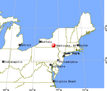
Nanticoke, New York
Submit your own pictures of this town and show them to the world
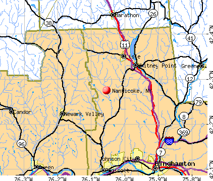
- OSM Map
- General Map
- Google Map
- MSN Map
Population change since 2000: -6.6%
 |
| Males: 845 | |
| Females: 827 |
| Median resident age: | 39.8 years |
| New York median age: | 40.7 years |
Zip codes: 13802.
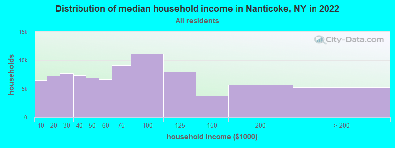
| Nanticoke: | $63,041 |
| NY: | $79,557 |
Estimated per capita income in 2022: $27,011 (it was $15,683 in 2000)
Nanticoke town income, earnings, and wages data
Estimated median house or condo value in 2022: $117,472 (it was $59,500 in 2000)
| Nanticoke: | $117,472 |
| NY: | $400,400 |
Mean prices in 2022: all housing units: $180,458; detached houses: $178,249; townhouses or other attached units: $268,846; in 2-unit structures: $138,144; in 3-to-4-unit structures: $139,592; in 5-or-more-unit structures: $758,756; mobile homes: $62,903
Detailed information about poverty and poor residents in Nanticoke, NY


- 1,62397.1%White alone
- 261.6%Two or more races
- 110.7%Hispanic
- 70.4%Black alone
- 30.2%American Indian alone
- 20.1%Asian alone
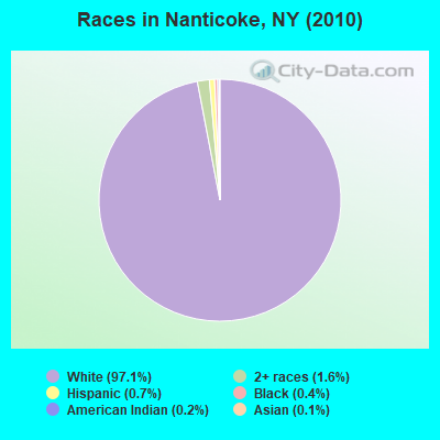
Races in Nanticoke detailed stats: ancestries, foreign born residents, place of birth
 Recent articles from our blog. Our writers, many of them Ph.D. graduates or candidates, create easy-to-read articles on a wide variety of topics.

 | Native American culture in NY State (1077 replies) |
| smaller Upstate NY cities and towns/African American communities (5974 replies) |
| Is Fayetteville the only village in the state with more than 1 business district? (18 replies) |
| Buying a house in Binghamton (14 replies) |
| Can anyone tell me about BINGHAMTON? (62 replies) |
| Weird thing I noticed? (5 replies) |
Latest news from Nanticoke, NY collected exclusively by city-data.com from local newspapers, TV, and radio stations
Ancestries: German (18.7%), English (15.8%), Irish (14.8%), United States (12.0%), Dutch (6.0%), Italian (4.9%).
Current Local Time: EST time zone
Elevation: 1101 feet
Land area: 24.3 square miles.
Population density: 69 people per square mile (very low).
19 residents are foreign born
| This town: | 1.1% |
| New York: | 20.4% |
| Nanticoke town: | 2.1% ($1,270) |
| New York: | 1.9% ($2,847) |
Nearest city with pop. 50,000+: Union, NY (11.8 miles  , pop. 56,298).
Nearest city with pop. 200,000+: Rochester, NY (101.0 miles , pop. 219,773).
Nearest city with pop. 1,000,000+: Manhattan, NY (149.2 miles , pop. 1,537,195).
Nearest cities:
), ), ), ), ), ), )Latitude: 42.28 N, Longitude: 76.02 W
Area code commonly used in this area: 607

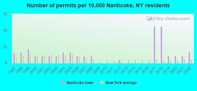
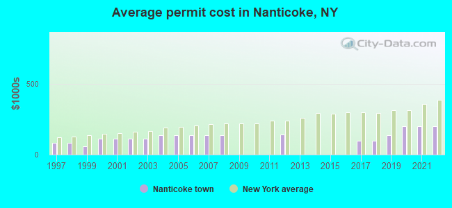
Single-family new house construction building permits:
- 2022: 3 buildings, average cost: $200,000
- 2021: 2 buildings, average cost: $200,000
- 2020: 2 buildings, average cost: $200,000
- 2019: 2 buildings, average cost: $134,500
- 2018: 10 buildings, average cost: $100,000
- 2017: 10 buildings, average cost: $100,000
- 2012: 1 building, cost: $140,000
- 2008: 2 buildings, average cost: $138,800
- 2007: 2 buildings, average cost: $138,800
- 2006: 2 buildings, average cost: $138,800
- 2005: 3 buildings, average cost: $138,800
- 2004: 3 buildings, average cost: $138,800
- 2003: 2 buildings, average cost: $112,500
- 2002: 2 buildings, average cost: $112,500
- 2001: 2 buildings, average cost: $112,500
- 2000: 2 buildings, average cost: $112,500
- 1999: 4 buildings, average cost: $59,100
- 1998: 3 buildings, average cost: $83,300
- 1997: 3 buildings, average cost: $83,300
| Here: | 4.7% |
| New York: | 4.4% |
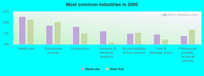
- Health care (12.8%)
- Educational services (8.7%)
- Construction (8.2%)
- Computer & electronic products (6.2%)
- Accommodation & food services (5.0%)
- Food & beverage stores (4.7%)
- Professional, scientific, technical services (4.0%)
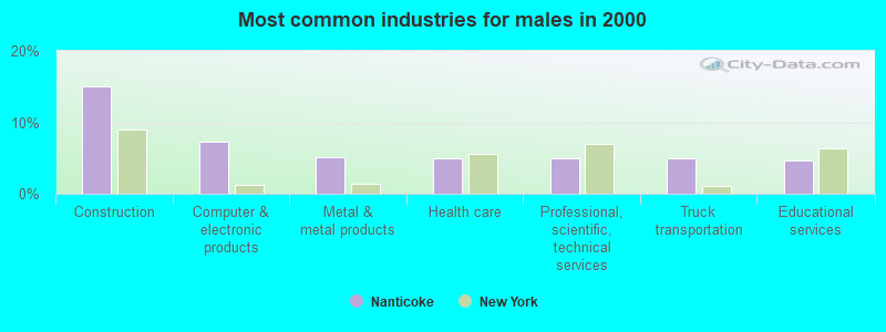
- Construction (15.0%)
- Computer & electronic products (7.3%)
- Metal & metal products (5.2%)
- Health care (4.9%)
- Professional, scientific, technical services (4.9%)
- Truck transportation (4.9%)
- Educational services (4.7%)
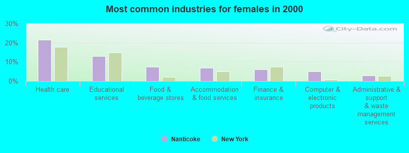
- Health care (21.5%)
- Educational services (13.1%)
- Food & beverage stores (7.3%)
- Accommodation & food services (6.8%)
- Finance & insurance (6.0%)
- Computer & electronic products (5.0%)
- Administrative & support & waste management services (2.9%)
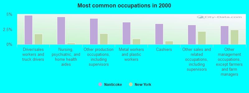
- Driver/sales workers and truck drivers (4.8%)
- Nursing, psychiatric, and home health aides (4.6%)
- Other production occupations, including supervisors (4.3%)
- Metal workers and plastic workers (3.7%)
- Cashiers (3.5%)
- Other sales and related occupations, including supervisors (3.2%)
- Other management occupations, except farmers and farm managers (3.1%)
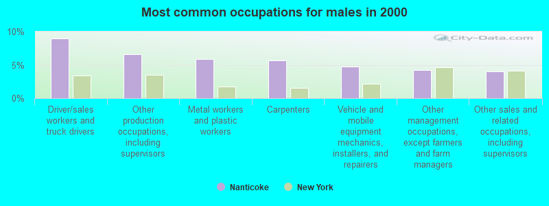
- Driver/sales workers and truck drivers (8.9%)
- Other production occupations, including supervisors (6.6%)
- Metal workers and plastic workers (5.9%)
- Carpenters (5.6%)
- Vehicle and mobile equipment mechanics, installers, and repairers (4.7%)
- Other management occupations, except farmers and farm managers (4.2%)
- Other sales and related occupations, including supervisors (4.0%)
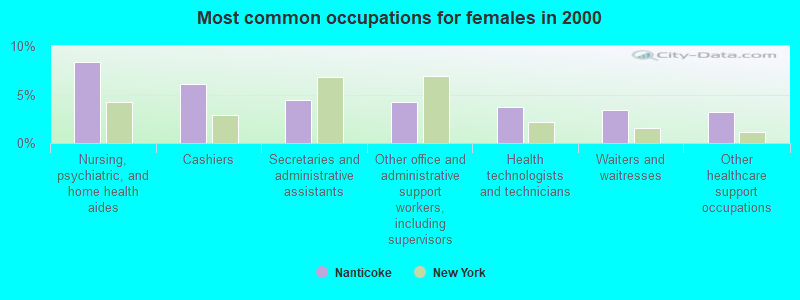
- Nursing, psychiatric, and home health aides (8.4%)
- Cashiers (6.0%)
- Secretaries and administrative assistants (4.5%)
- Other office and administrative support workers, including supervisors (4.2%)
- Health technologists and technicians (3.7%)
- Waiters and waitresses (3.4%)
- Other healthcare support occupations (3.1%)
Average climate in Nanticoke, New York
Based on data reported by over 4,000 weather stations


Tornado activity:
Nanticoke-area historical tornado activity is near New York state average. It is 64% smaller than the overall U.S. average.
On 5/31/1998, a category F3 (max. wind speeds 158-206 mph) tornado 16.2 miles away from the Nanticoke town center injured 12 people and caused $3 million in damages.
On 5/2/1983, a category F3 tornado 24.4 miles away from the town center injured 6 people and caused between $500,000 and $5,000,000 in damages.
Earthquake activity:
Nanticoke-area historical earthquake activity is significantly above New York state average. It is 66% smaller than the overall U.S. average.On 10/7/1983 at 10:18:46, a magnitude 5.3 (5.1 MB, 5.3 LG, 5.1 ML, Class: Moderate, Intensity: VI - VII) earthquake occurred 143.3 miles away from the city center
On 4/20/2002 at 10:50:47, a magnitude 5.3 (5.3 ML, Depth: 3.0 mi) earthquake occurred 193.4 miles away from the city center
On 4/20/2002 at 10:50:47, a magnitude 5.2 (5.2 MB, 4.2 MS, 5.2 MW, 5.0 MW) earthquake occurred 191.4 miles away from the city center
On 8/23/2011 at 17:51:04, a magnitude 5.8 (5.8 MW, Depth: 3.7 mi) earthquake occurred 319.0 miles away from the city center
On 9/25/1998 at 19:52:52, a magnitude 5.2 (4.8 MB, 4.3 MS, 5.2 LG, 4.5 MW, Depth: 3.1 mi) earthquake occurred 231.7 miles away from the city center
On 1/16/1994 at 01:49:16, a magnitude 4.6 (4.6 MB, 4.6 LG, Depth: 3.1 mi, Class: Light, Intensity: IV - V) earthquake occurred 135.2 miles away from the city center
Magnitude types: regional Lg-wave magnitude (LG), body-wave magnitude (MB), local magnitude (ML), surface-wave magnitude (MS), moment magnitude (MW)
Natural disasters:
The number of natural disasters in Broome County (25) is a lot greater than the US average (15).Major Disasters (Presidential) Declared: 15
Emergencies Declared: 8
Causes of natural disasters: Floods: 11, Storms: 11, Snowstorms: 3, Tropical Storms: 3, Heavy Rains: 2, Hurricanes: 2, Tornadoes: 2, Blizzard: 1, Landslide: 1, Power Outage: 1, Tropical Depression: 1, Wind: 1, Winter Storm: 1, Other: 2 (Note: some incidents may be assigned to more than one category).

Hospitals and medical centers near Nanticoke:
- UNITED HEALTH SERVICES HOSPITALS, INC Acute Care Hospitals (about 5 miles away; JOHNSON CITY, NY)
- JAMES G JOHNSTON MEMORIAL NURSING HOME (Nursing Home, about 11 miles away; JOHNSON CITY, NY)
- ABSOLUT CTR FOR NURSING AND REHAB ENDICOTT L L C (Nursing Home, about 13 miles away; ENDICOTT, NY)
- BROOME DEVELOPMENTAL CENTER (Hospital, about 13 miles away; BINGHAMTON, NY)
- BROOME DDSO (Hospital, about 13 miles away; BINGHAMTON, NY)
- WILLOW POINT HRF (Nursing Home, about 13 miles away; VESTAL, NY)
- WILLOW POINT NURSING HOME (Nursing Home, about 13 miles away; VESTAL, NY)
Colleges/universities with over 2000 students nearest to Nanticoke:
- SUNY Broome Community College (about 12 miles; Binghamton, NY; Full-time enrollment: 4,969)
- SUNY at Binghamton (about 14 miles; Vestal, NY; FT enrollment: 15,096)
- Tompkins Cortland Community College (about 21 miles; Dryden, NY; FT enrollment: 3,884)
- SUNY College at Cortland (about 23 miles; Cortland, NY; FT enrollment: 6,838)
- Ithaca College (about 26 miles; Ithaca, NY; FT enrollment: 6,781)
- Cornell University (about 26 miles; Ithaca, NY; FT enrollment: 20,360)
- Colgate University (about 45 miles; Hamilton, NY; FT enrollment: 3,094)
Points of interest:
Notable locations in Nanticoke: Greenmuns Tree Farm (A), Sunny Hill Farm (B), Vandeburg Farms (C), Ford Hill Country Club (D), Fire Fox Golf Course (E). Display/hide their locations on the map
Cemetery: Glen Aubrey Cemetery (1). Display/hide its location on the map
| This town: | 2.8 people |
| New York: | 2.6 people |
| This town: | 76.7% |
| Whole state: | 63.5% |
| This town: | 11.5% |
| Whole state: | 6.8% |
Likely homosexual households (counted as self-reported same-sex unmarried-partner households)
- Lesbian couples: 0.3% of all households
- Gay men: 0.2% of all households
| This town: | 11.2% |
| Whole state: | 14.6% |
| This town: | 4.4% |
| Whole state: | 7.4% |
For population 15 years and over in Nanticoke:
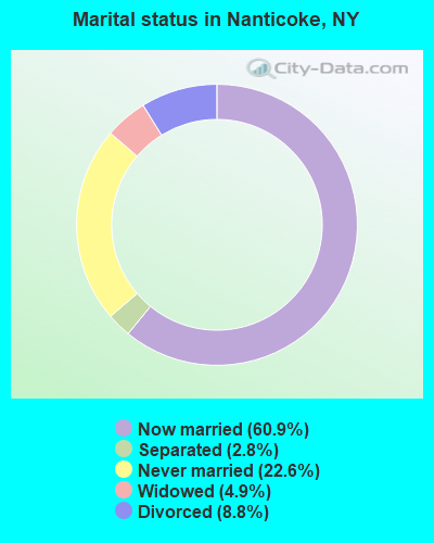
- Never married: 22.6%
- Now married: 60.9%
- Separated: 2.8%
- Widowed: 4.9%
- Divorced: 8.8%
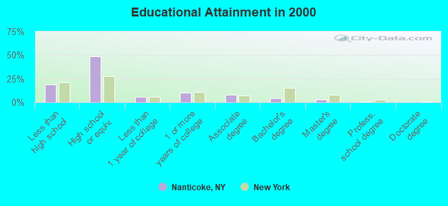
For population 25 years and over in Nanticoke:
- High school or higher: 80.9%
- Bachelor's degree or higher: 8.5%
- Graduate or professional degree: 3.8%
- Unemployed: 7.7%
- Mean travel time to work (commute): 31.7 minutes
| Here: | 8.9 |
| New York average: | 14.2 |
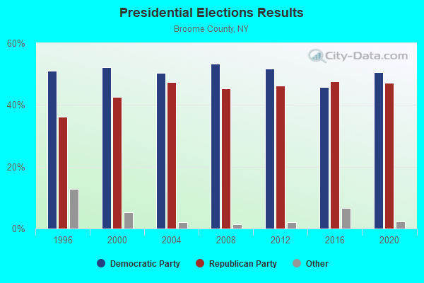
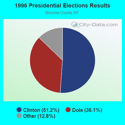
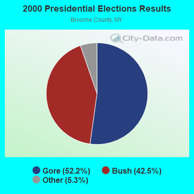
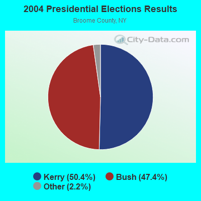
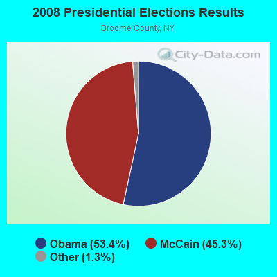
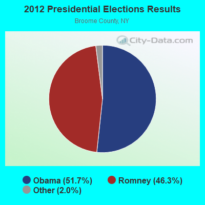
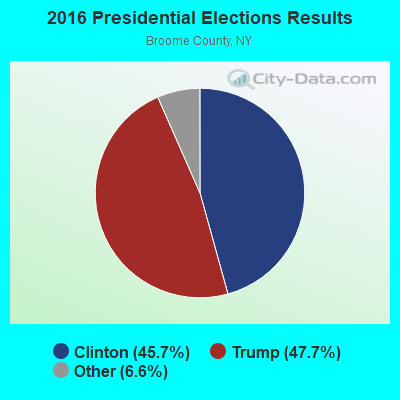
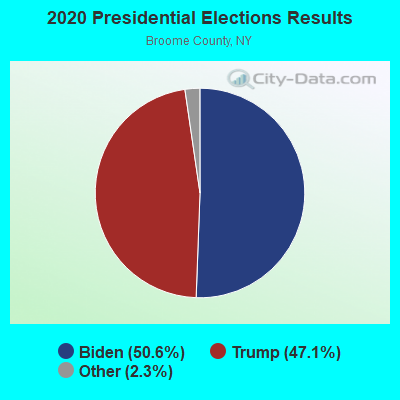
Graphs represent county-level data. Detailed 2008 Election Results
Religion statistics for Nanticoke, NY (based on Broome County data)
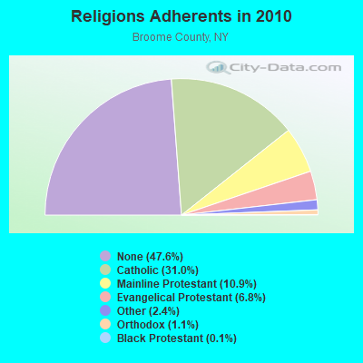
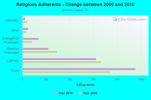
| Religion | Adherents | Congregations |
|---|---|---|
| Catholic | 62,220 | 34 |
| Mainline Protestant | 21,823 | 82 |
| Evangelical Protestant | 13,541 | 84 |
| Other | 4,900 | 18 |
| Orthodox | 2,285 | 9 |
| Black Protestant | 295 | 2 |
| None | 95,536 | - |
Food Environment Statistics:
| Broome County: | 1.64 / 10,000 pop. |
| State: | 4.13 / 10,000 pop. |
| Broome County: | 0.10 / 10,000 pop. |
| New York: | 0.06 / 10,000 pop. |
| This county: | 0.67 / 10,000 pop. |
| State: | 0.92 / 10,000 pop. |
| Broome County: | 4.14 / 10,000 pop. |
| New York: | 1.68 / 10,000 pop. |
| Here: | 8.13 / 10,000 pop. |
| New York: | 8.82 / 10,000 pop. |
| This county: | 8.6% |
| New York: | 8.2% |
| Broome County: | 27.0% |
| New York: | 23.8% |
| Broome County: | 14.7% |
| New York: | 15.6% |
Strongest AM radio stations in Nanticoke:
- WINR (680 AM; 5 kW; BINGHAMTON, NY; Owner: CLEVELAND RADIO LICENSES, LLC)
- WNBF (1290 AM; 9 kW; BINGHAMTON, NY; Owner: CITADEL BROADCASTING COMPANY)
- WENE (1430 AM; 5 kW; ENDICOTT, NY; Owner: CLEAR CHANNEL BROADCASTING LICENSES, INC.)
- WYOS (1360 AM; 5 kW; BINGHAMTON, NY; Owner: CITADEL BROADCASTING COMPANY)
- WEBO (1330 AM; 5 kW; OWEGO, NY; Owner: TIOGA MEDIA, INC.)
- WHCU (870 AM; 5 kW; ITHACA, NY; Owner: EAGLE BROADCASTING COMPANY, INC.)
- WTKO (1470 AM; 5 kW; ITHACA, NY; Owner: EAGLE II BROADCASTING CORPORATION)
- WATS (960 AM; 5 kW; SAYRE, PA; Owner: WATS BROADCASTING, INC.)
- WGY (810 AM; 50 kW; SCHENECTADY, NY; Owner: CLEAR CHANNEL BROADCASTING LICENSES, INC.)
- WHAM (1180 AM; 50 kW; ROCHESTER, NY; Owner: CITICASTERS LICENSES, L.P.)
- WWJZ (640 AM; 50 kW; MOUNT HOLLY, NJ; Owner: ABC, INC.)
- WMCA (570 AM; 50 kW; NEW YORK, NY; Owner: SALEM MEDIA OF NEW YORK, LLC)
- WSYR (570 AM; 5 kW; SYRACUSE, NY; Owner: CLEAR CHANNEL BROADCASTING LICENSES, INC.)
Strongest FM radio stations in Nanticoke:
- WHWK (98.1 FM; BINGHAMTON, NY; Owner: CITADEL BROADCASTING COMPANY)
- WSQX-FM (91.5 FM; BINGHAMTON, NY; Owner: WSKG PUBLIC TELECOMMUNICATIONS CNCL.)
- WAAL (99.1 FM; BINGHAMTON, NY; Owner: CITADEL BROADCASTING COMPANY)
- WMRV-FM (105.7 FM; ENDICOTT, NY; Owner: CLEAR CHANNEL BROADCASTING LICENSES, INC.)
- WSKG-FM (89.3 FM; BINGHAMTON, NY; Owner: WSKG PUB.TELECOMMUNICATIONS COUNCIL)
- WBBI (107.5 FM; ENDWELL, NY; Owner: CLEAR CHANNEL BROADCASTING LICENSES, INC.)
- WMXW (103.3 FM; VESTAL, NY; Owner: CLEAR CHANNEL BROADCASTING LICENSES, INC.)
- WLTB (101.7 FM; JOHNSON CITY, NY; Owner: GM BROADCASTING, INC.)
- WWYL (104.1 FM; CHENANGO BRIDGE, NY; Owner: CITADEL BROADCASTING COMPANY)
- WKGB-FM (92.5 FM; CONKLIN, NY; Owner: CLEAR CHANNEL BROADCASTING LICENSES, INC.)
- W273AB (102.5 FM; OWEGO, NY; Owner: WEBO RADIO, INC.)
- WYXL (97.3 FM; ITHACA, NY; Owner: EAGLE BROADCASTING COMPANY)
- WIII (99.9 FM; CORTLAND, NY; Owner: CITADEL BROADCASTING COMPANY)
- WIFF (90.1 FM; BINGHAMTON, NY; Owner: CSN INTERNATIONAL)
- WCDW (100.5 FM; CONKLIN, NY; Owner: EQUINOX BROADCASTING CORPORATION)
- WBKT (95.3 FM; NORWICH, NY; Owner: BANJO COMMUNICATIONS GROUP, INC)
- WCII (88.5 FM; SPENCER, NY; Owner: FAMILY LIFE MINISTRIES, INC.)
- WQNY (103.7 FM; ITHACA, NY; Owner: EAGLE II BROADCASTING CORPORATION)
- W293AC (106.5 FM; BINGHAMTON, NY; Owner: MONTROSE BROADCASTING CORPORATION)
- W221AX (92.1 FM; ENDWELL, NY; Owner: CLEAR CHANNEL BROADCASTING LICENSES, INC.)
TV broadcast stations around Nanticoke:
- WSKG-TV (Channel 46; BINGHAMTON, NY; Owner: WSKG PUBLIC TELECOMMUNICATIONS COUNCIL)
- WICZ-TV (Channel 40; BINGHAMTON, NY; Owner: STAINLESS BROADCASTING, L.P.)
- WBNG-TV (Channel 12; BINGHAMTON, NY; Owner: TELEVISION STATION GROUP LICENSE SUBSIDIARY, LLC)
- W26BS (Channel 14; BINGHAMTON, NY; Owner: TRINITY BROADCASTING NETWORK)
- WIVT (Channel 34; BINGHAMTON, NY; Owner: CENTRAL NY NEWS, INC.)
- WBPN-LP (Channel 10; BINGHAMTON, NY; Owner: STAINLESS BROADCASTING, L.P.)
- WBGH-CA (Channel 20; BINGHAMTON, NY; Owner: CENTRAL NY NEWS, INC.)
- WCNY-TV (Channel 24; SYRACUSE, NY; Owner: PUBLIC BROADCASTING COUNCIL OF CENTRAL NEW YORK)
- WSYT (Channel 68; SYRACUSE, NY; Owner: WSYT LICENSEE L.P.)
- National Bridge Inventory (NBI) Statistics
- 7Number of bridges
- 36ft / 11.1mTotal length
- $6,638,000Total costs
- 12,419Total average daily traffic
- 782Total average daily truck traffic
- 12,815Total future (year 2037) average daily traffic
FCC Registered Antenna Towers:
6- Elaine Evans, 350 Rabbit Path Road (Lat: 42.278222 Lon: -76.020500), Type: 61.0, Structure height: 36007 m, Overall height: 61 m, Registrant: Tarpon Towers Ii, LLC, Tbowman@tarpontowers.Com, Suite 103, Lakew-ood Ranch, Phone: (941) 757-5010
- Elaine Evans, 350 Rabbit Path Road (Lat: 42.278222 Lon: -76.020500), Type: 61.0, Structure height: 36007 m, Overall height: 61 m, Registrant: Tarpon Towers Ii, LLC, Tbowman@tarpontowers.Com, Suite 103, Lakew-ood Ranch, Phone: (941) 757-5010
- Todd J Bowman, 350 Rabbit Path Road (Lat: 42.278222 Lon: -76.020500), Type: 61.0, Structure height: 36007 m, Overall height: 61 m, Registrant: Tarpon Towers Iii, LLC, Tbowman@tarpontowers.Com, Suite 103, Lakew-ood Ranch, Phone: (941) 757-5010
- Todd J Bowman, 350 Rabbit Path Road (Lat: 42.278222 Lon: -76.020500), Type: 61.0, Structure height: 36007 m, Overall height: 61 m, Registrant: Tarpon Towers Iii, LLC, Tbowman@tarpontowers.Com, Suite 103, Lakew-ood Ranch, Phone: (941) 757-5010
- Elaine Evans, 350 Rabbit Path Road (Lat: 42.278222 Lon: -76.020500), Type: 61.0, Structure height: 36007 m, Overall height: 61 m, Registrant: Tarpon Towers Iii, LLC, Tbowman@tarpontowers.Com, Suite 103, Lakew-ood Ranch, Phone: (941) 757-5010
- Elaine Evans, 350 Rabbit Path Road (Lat: 42.278222 Lon: -76.020500), Type: 61.0, Structure height: 36007 m, Overall height: 61 m, Licensee ID: L, Registrant: Tarpon Towers Iii, LLC, Tbowman@tarpontowers.Com, Suite 103, 34202 Lakew-ood Ranch, Phone: (941) 757-5010
FCC Registered Microwave Towers:
1- LANDFILL, 256 Knapp Rd (Lat: 42.238500 Lon: -75.981528), Type: Pipe, Structure height: 4.9 m, Overall height: 5.5 m, Call Sign: WRDY693,
Assigned Frequencies: 6212.06 MHz, 6212.06 MHz, 6212.06 MHz, 6212.06 MHz, 6212.06 MHz, 6212.06 MHz, 6212.06 MHz, 6212.06 MHz, Grant Date: 08/21/2019, Expiration Date: 08/21/2029, Certifier: Tom Vroman, Registrant: County Of Broome, 153 Lt. Vanwinkle Drive, Binghamton, NY 13905, Phone: (607) 778-8214, Email:
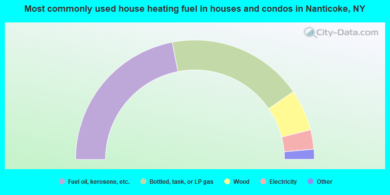
- 43.9%Fuel oil, kerosene, etc.
- 36.9%Bottled, tank, or LP gas
- 11.2%Wood
- 5.3%Electricity
- 1.4%Other fuel
- 1.2%Coal or coke
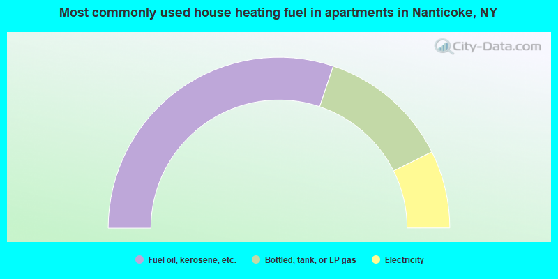
- 60.3%Fuel oil, kerosene, etc.
- 25.0%Bottled, tank, or LP gas
- 14.7%Electricity
Nanticoke compared to New York state average:
- Median house value significantly below state average.
- Unemployed percentage below state average.
- Black race population percentage significantly below state average.
- Hispanic race population percentage significantly below state average.
- Foreign-born population percentage significantly below state average.
- Renting percentage significantly below state average.
- Length of stay since moving in significantly above state average.
- Number of rooms per house significantly below state average.
- House age significantly below state average.
- Number of college students below state average.
- Percentage of population with a bachelor's degree or higher significantly below state average.