Mukwa, Wisconsin
Submit your own pictures of this town and show them to the world
- OSM Map
- Google Map
- MSN Map
Population change since 2000: +5.7%
 |
| Males: 1,481 | |
| Females: 1,449 |
| Median resident age: | 43.9 years |
| Wisconsin median age: | 42.6 years |
Zip codes: 54983.
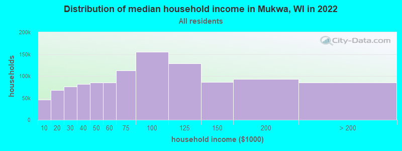
| Mukwa: | $86,104 |
| WI: | $70,996 |
Estimated per capita income in 2022: $44,644 (it was $21,254 in 2000)
Mukwa town income, earnings, and wages data
Estimated median house or condo value in 2022: $250,512 (it was $117,800 in 2000)
| Mukwa: | $250,512 |
| WI: | $252,800 |
Mean prices in 2022: all housing units: $242,326; detached houses: $243,599; townhouses or other attached units: $213,855; in 2-unit structures: $165,520; in 3-to-4-unit structures: over $1,000,000; in 5-or-more-unit structures: $247,705; mobile homes: $177,749
Detailed information about poverty and poor residents in Mukwa, WI
Compare current foreclosures near Mukwa, WI:
| Photo | Address | Area | Beds / Baths | Price | Details |
|---|---|---|---|---|---|

|
#1
Mill St
Manawa, WI 54949
|
- sq. feet
|
- baths - beds |
$34,900
|
show details |

|
#2
W Main St
Weyauwega, WI 54983
|
- sq. feet
|
2 baths 4 beds |
show details | |

|
#3
Cemetery Rd
Weyauwega, WI 54983
|
- sq. feet
|
- baths 3 beds |
show details | |

|
#4
Buelow Rd
New London, WI 54961
|
1,178 sq. feet
|
2 baths 3 beds |
show details | |

|
#5
W Jennings St Apt 3
New London, WI 54961
|
- sq. feet
|
- baths - beds |
show details | |

|
#6
Broad St
Shiocton, WI 54170
|
- sq. feet
|
- baths - beds |
show details | |

|
#7
Oak St
Shiocton, WI 54170
|
- sq. feet
|
- baths - beds |
show details | |

|
#8
Oak St, Trlr 203
Waupaca, WI 54981
|
- sq. feet
|
- baths - beds |
show details | |

|
#9
W Maple Ct
Shiocton, WI 54170
|
- sq. feet
|
- baths - beds |
show details | |

|
#10
Milly St
Greenville, WI 54942
|
- sq. feet
|
- baths - beds |
show details |
| Photo | Address | Area | Beds / Baths | Price | Details |
|---|---|---|---|---|---|

|
#11
Midnight Way
Greenville, WI 54942
|
- sq. feet
|
- baths - beds |
show details | |

|
#12
Medina Dr
Greenville, WI 54942
|
- sq. feet
|
- baths - beds |
show details | |

|
#13
Fairwinds Dr
Greenville, WI 54942
|
- sq. feet
|
- baths - beds |
show details | |

|
#14
Waterlefe Dr
Greenville, WI 54942
|
- sq. feet
|
- baths - beds |
show details | |

|
#15
Carpenter Rd
Shiocton, WI 54170
|
- sq. feet
|
- baths - beds |
show details | |

|
#16
Alexandra Way
Greenville, WI 54942
|
- sq. feet
|
- baths - beds |
show details | |

|
#17
Bags Hill Rd
Waupaca, WI 54981
|
- sq. feet
|
- baths - beds |
show details | |

|
#18
Redwing Dr
Greenville, WI 54942
|
- sq. feet
|
- baths - beds |
show details | |

|
#19
Star Dust Dr
Greenville, WI 54942
|
- sq. feet
|
- baths - beds |
show details | |

|
#20
Aspen Ave
Pine River, WI 54965
|
- sq. feet
|
- baths - beds |
show details |
| Photo | Address | Area | Beds / Baths | Price | Details |
|---|---|---|---|---|---|

|
#21
Mayflower Rd
Appleton, WI 54913
|
- sq. feet
|
- baths - beds |
show details | |

|
#22
Mitchell Ave
Waupaca, WI 54981
|
- sq. feet
|
- baths - beds |
show details | |

|
#23
County Road Ii Lot 5
Larsen, WI 54947
|
- sq. feet
|
- baths - beds |
show details | |

|
#24
E 2nd St
Clintonville, WI 54929
|
- sq. feet
|
- baths - beds |
show details | |

|
#25
State Road 76
Hortonville, WI 54944
|
- sq. feet
|
- baths - beds |
show details | |

|
#26
Royalton St
Waupaca, WI 54981
|
- sq. feet
|
- baths - beds |
show details | |

|
#27
Cemetery Rd
Weyauwega, WI 54983
|
- sq. feet
|
- baths - beds |
show details | |

|
#28
Wells St
Manawa, WI 54949
|
- sq. feet
|
- baths - beds |
show details | |

|
#29
W Jennings St Apt 2
New London, WI 54961
|
- sq. feet
|
- baths - beds |
show details | |

|
#30
Stage Rd
New London, WI 54961
|
- sq. feet
|
- baths - beds |
show details |
| Photo | Address | Area | Beds / Baths | Price | Details |
|---|---|---|---|---|---|

|
#31
1/2 E Cook St
New London, WI 54961
|
- sq. feet
|
- baths - beds |
show details | |

|
#32
Wallace St Apt 5
New London, WI 54961
|
- sq. feet
|
- baths - beds |
show details | |

|
#33
E Beacon Ave Apt 5
New London, WI 54961
|
- sq. feet
|
- baths - beds |
show details | |

|
#34
E Alfred St
Weyauwega, WI 54983
|
- sq. feet
|
- baths - beds |
show details | |

|
#35
W Cameron St Apt 2
New London, WI 54961
|
- sq. feet
|
- baths - beds |
show details | |

|
#36
Buelow Rd
New London, WI 54961
|
- sq. feet
|
- baths - beds |
show details | |

|
#37
Gaigg Ln
Hortonville, WI 54944
|
- sq. feet
|
- baths - beds |
show details | |

|
#38
Buboltz Rd
New London, WI 54961
|
- sq. feet
|
- baths - beds |
show details | |

|
#39
State Highway 15
Hortonville, WI 54944
|
- sq. feet
|
- baths - beds |
show details | |

|
#40
Midway Rd
Hortonville, WI 54944
|
- sq. feet
|
- baths - beds |
show details |
| Photo | Address | Area | Beds / Baths | Price | Details |
|---|---|---|---|---|---|

|
#41
Clark St
Manawa, WI 54949
|
- sq. feet
|
- baths - beds |
show details | |

|
#42
W Main St # 3
Weyauwega, WI 54983
|
- sq. feet
|
- baths - beds |
show details | |

|
#43
Washington St
Fremont, WI 54940
|
- sq. feet
|
- baths - beds |
show details | |

|
#44
S Nash St
Hortonville, WI 54944
|
- sq. feet
|
- baths - beds |
show details | |

|
#45
E Quincy St
New London, WI 54961
|
- sq. feet
|
- baths - beds |
show details | |

|
#46
E Pine St
New London, WI 54961
|
- sq. feet
|
- baths - beds |
show details | |

|
#47
Grand View Rd
Hortonville, WI 54944
|
- sq. feet
|
- baths - beds |
show details | |

|
#48
Mud Creek Rd
Winneconne, WI 54986
|
- sq. feet
|
- baths - beds |
show details | |

|
#49
Waupaca St
Clintonville, WI 54929
|
- sq. feet
|
- baths - beds |
show details | |

|
Check over 1 million property listings on Foreclosure.com!
|
browse all offers | |||

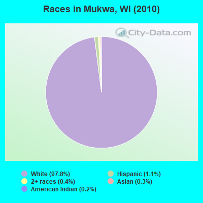
- 2,86797.8%White alone
- 321.1%Hispanic
- 130.4%Two or more races
- 100.3%Asian alone
- 70.2%American Indian alone
- 10.03%Black alone
Races in Mukwa detailed stats: ancestries, foreign born residents, place of birth
 Recent articles from our blog. Our writers, many of them Ph.D. graduates or candidates, create easy-to-read articles on a wide variety of topics.
Ancestries: German (59.5%), Irish (16.5%), French (6.9%), Polish (5.9%), Norwegian (5.1%), Dutch (4.1%).
Current Local Time: CST time zone
Land area: 31.4 square miles.
Population density: 93 people per square mile (very low).
10 residents are foreign born
| This town: | 0.4% |
| Wisconsin: | 3.6% |
| Mukwa town: | 1.5% ($1,713) |
| Wisconsin: | 2.0% ($2,245) |
Nearest city with pop. 50,000+: Appleton, WI  (21.9 miles , pop. 70,087).
Nearest city with pop. 200,000+: Madison, WI (94.6 miles , pop. 208,054).
Nearest city with pop. 1,000,000+: Chicago, IL (184.6 miles , pop. 2,896,016).
Nearest cities:
), ), ), ), ), ), )Latitude: 44.38 N, Longitude: 88.82 W
Area code commonly used in this area: 920
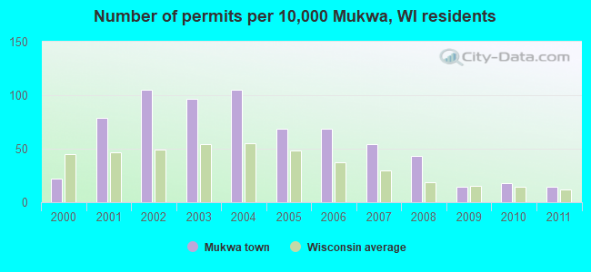
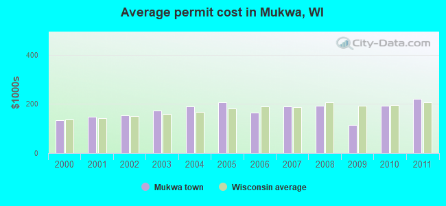
Single-family new house construction building permits:
- 2011: 4 buildings, average cost: $220,500
- 2010: 5 buildings, average cost: $191,800
- 2009: 4 buildings, average cost: $114,800
- 2008: 12 buildings, average cost: $191,600
- 2007: 15 buildings, average cost: $189,300
- 2006: 19 buildings, average cost: $165,600
- 2005: 19 buildings, average cost: $207,400
- 2004: 29 buildings, average cost: $188,600
- 2003: 27 buildings, average cost: $171,500
- 2002: 29 buildings, average cost: $154,200
- 2001: 22 buildings, average cost: $148,000
- 2000: 6 buildings, average cost: $132,500
| Here: | 2.8% |
| Wisconsin: | 2.7% |
- Food (9.3%)
- Plastics & rubber products (9.1%)
- Health care (9.1%)
- Construction (8.5%)
- Educational services (6.2%)
- Paper (5.3%)
- Accommodation & food services (4.1%)
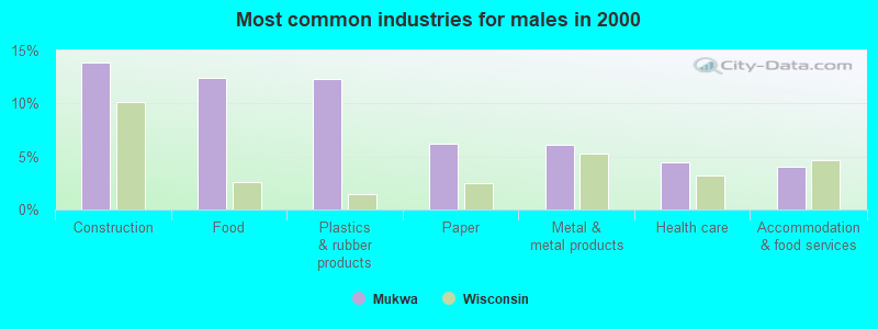
- Construction (13.8%)
- Food (12.5%)
- Plastics & rubber products (12.3%)
- Paper (6.2%)
- Metal & metal products (6.1%)
- Health care (4.5%)
- Accommodation & food services (4.0%)
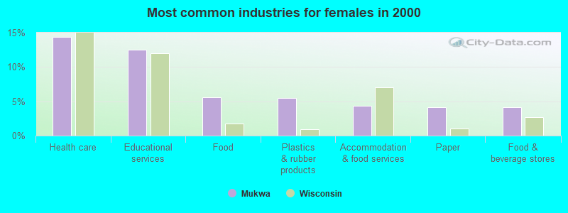
- Health care (14.4%)
- Educational services (12.5%)
- Food (5.6%)
- Plastics & rubber products (5.5%)
- Accommodation & food services (4.3%)
- Paper (4.2%)
- Food & beverage stores (4.2%)
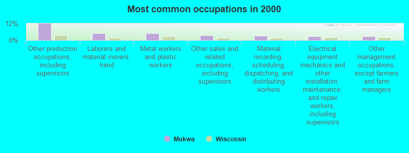
- Other production occupations, including supervisors (11.9%)
- Laborers and material movers, hand (5.2%)
- Metal workers and plastic workers (5.1%)
- Other sales and related occupations, including supervisors (3.5%)
- Material recording, scheduling, dispatching, and distributing workers (3.3%)
- Electrical equipment mechanics and other installation, maintenance, and repair workers, including supervisors (3.0%)
- Other management occupations, except farmers and farm managers (2.9%)
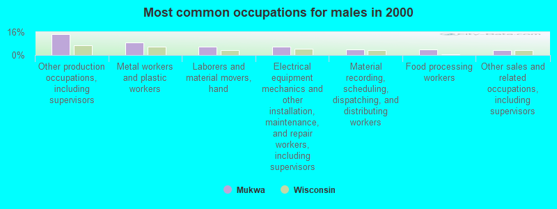
- Other production occupations, including supervisors (14.4%)
- Metal workers and plastic workers (9.0%)
- Laborers and material movers, hand (5.6%)
- Electrical equipment mechanics and other installation, maintenance, and repair workers, including supervisors (5.6%)
- Material recording, scheduling, dispatching, and distributing workers (4.1%)
- Food processing workers (3.9%)
- Other sales and related occupations, including supervisors (3.4%)
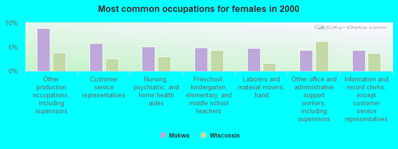
- Other production occupations, including supervisors (8.9%)
- Customer service representatives (5.7%)
- Nursing, psychiatric, and home health aides (5.0%)
- Preschool, kindergarten, elementary, and middle school teachers (4.9%)
- Laborers and material movers, hand (4.7%)
- Other office and administrative support workers, including supervisors (4.3%)
- Information and record clerks, except customer service representatives (4.3%)
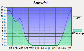
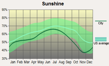
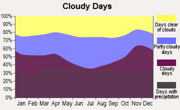
Average climate in Mukwa, Wisconsin
Based on data reported by over 4,000 weather stations


(lower is better)
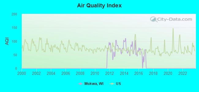
Air Quality Index (AQI) level in 2016 was 58.0. This is better than average.
| City: | 58.0 |
| U.S.: | 72.6 |
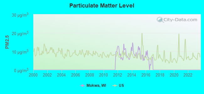
Particulate Matter (PM2.5) [µg/m3] level in 2016 was 6.47. This is better than average. Closest monitor was 11.8 miles away from the city center.
| City: | 6.47 |
| U.S.: | 8.11 |
Tornado activity:
Mukwa-area historical tornado activity is slightly above Wisconsin state average. It is 29% greater than the overall U.S. average.
On 9/26/1951, a category F4 (max. wind speeds 207-260 mph) tornado 6.7 miles away from the Mukwa town center killed 6 people and injured 3 people and caused between $50,000 and $500,000 in damages.
On 4/27/1984, a category F4 tornado 20.8 miles away from the town center killed one person and injured 19 people and caused between $500,000 and $5,000,000 in damages.
Earthquake activity:
Mukwa-area historical earthquake activity is significantly above Wisconsin state average. It is 9% smaller than the overall U.S. average.On 6/28/2004 at 06:10:52, a magnitude 4.2 (4.2 MW, Depth: 6.2 mi, Class: Light, Intensity: IV - V) earthquake occurred 201.8 miles away from Mukwa center
On 4/18/2008 at 09:36:59, a magnitude 5.4 (5.1 MB, 4.8 MS, 5.4 MW, 5.2 MW, Class: Moderate, Intensity: VI - VII) earthquake occurred 412.6 miles away from Mukwa center
On 5/2/2015 at 16:23:07, a magnitude 4.2 (4.2 MW, Depth: 2.8 mi) earthquake occurred 225.8 miles away from the city center
On 6/10/1987 at 23:48:54, a magnitude 5.1 (4.9 MB, 4.4 MS, 4.6 MS, 5.1 LG) earthquake occurred 387.3 miles away from the city center
On 2/10/2010 at 09:59:35, a magnitude 3.8 (3.8 MW, Depth: 6.2 mi, Class: Light, Intensity: II - III) earthquake occurred 167.3 miles away from Mukwa center
On 4/18/2008 at 09:36:59, a magnitude 5.2 (5.2 MW, Depth: 8.9 mi) earthquake occurred 412.7 miles away from the city center
Magnitude types: regional Lg-wave magnitude (LG), body-wave magnitude (MB), surface-wave magnitude (MS), moment magnitude (MW)
Natural disasters:
The number of natural disasters in Waupaca County (9) is smaller than the US average (15).Major Disasters (Presidential) Declared: 6
Emergencies Declared: 2
Causes of natural disasters: Floods: 6, Storms: 5, Tornadoes: 3, Drought: 1, Hurricane: 1, Wind: 1, Other: 1 (Note: some incidents may be assigned to more than one category).
Hospitals and medical centers near Mukwa:
- ST JOSEPH RESIDENCE (Nursing Home, about 4 miles away; NEW LONDON, WI)
- WEYAUWEGA HEALTH CARE CTR (Nursing Home, about 8 miles away; WEYAUWEGA, WI)
- LAKEVIEW MANOR (Nursing Home, about 8 miles away; WEYAUWEGA, WI)
- MANAWA COM NUR CTR (Nursing Home, about 8 miles away; MANAWA, WI)
- HOSPICE PGM WAUPACA CTY (Hospital, about 13 miles away; WAUPACA, WI)
- RECOVER HEALTH OF WISCONSIN INC (Home Health Center, about 13 miles away; WAUPACA, WI)
- RIVERSIDE MEDICAL CENTER, INC Critical Access Hospitals (about 14 miles away; WAUPACA, WI)
Colleges/universities with over 2000 students nearest to Mukwa:
- Fox Valley Technical College (about 19 miles; Appleton, WI; Full-time enrollment: 5,682)
- Lawrence University (about 23 miles; Appleton, WI; FT enrollment: 2,821)
- University of Wisconsin-Oshkosh (about 28 miles; Oshkosh, WI; FT enrollment: 10,637)
- Northeast Wisconsin Technical College (about 37 miles; Green Bay, WI; FT enrollment: 6,069)
- Saint Norbert College (about 38 miles; De Pere, WI; FT enrollment: 2,324)
- University of Wisconsin-Stevens Point (about 39 miles; Stevens Point, WI; FT enrollment: 9,089)
- University of Wisconsin-Green Bay (about 46 miles; Green Bay, WI; FT enrollment: 5,415)
Points of interest:
Notable locations in Mukwa: Vic-to-Rae Camp (A), Stanleys Landing (B), Parfitt Landing (C). Display/hide their locations on the map
Cemeteries: Ostrander-Northport Cemetery (1), Old Ostrander Cemetery (2). Display/hide their locations on the map
Lakes: Tom Bayou (A), Traders Bayou (B), Cincoe Lake (C), Little Horseshoe Bayou (D). Display/hide their locations on the map
Rivers and creeks: Potters Creek (A), Cedar Creek (B), Little Wolf River (C). Display/hide their locations on the map
Parks in Mukwa include: Wolf River State Fishery Area (1), Mukwa Bottomland Forest State Natural Area (2), Poppy's Rock State Natural Area (3), Mukwa State Wildlife Area (4). Display/hide their locations on the map
| This town: | 2.5 people |
| Wisconsin: | 2.4 people |
| This town: | 77.2% |
| Whole state: | 64.4% |
| This town: | 5.9% |
| Whole state: | 7.3% |
Likely homosexual households (counted as self-reported same-sex unmarried-partner households)
- Lesbian couples: 0.5% of all households
- Gay men: 0.0% of all households
| This town: | 3.5% |
| Whole state: | 8.7% |
| This town: | 1.0% |
| Whole state: | 3.7% |
For population 15 years and over in Mukwa:
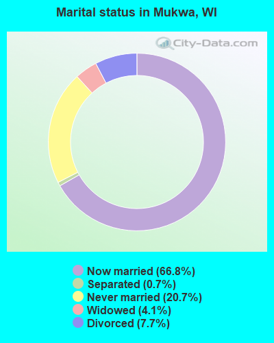
- Never married: 20.7%
- Now married: 66.8%
- Separated: 0.7%
- Widowed: 4.1%
- Divorced: 7.7%
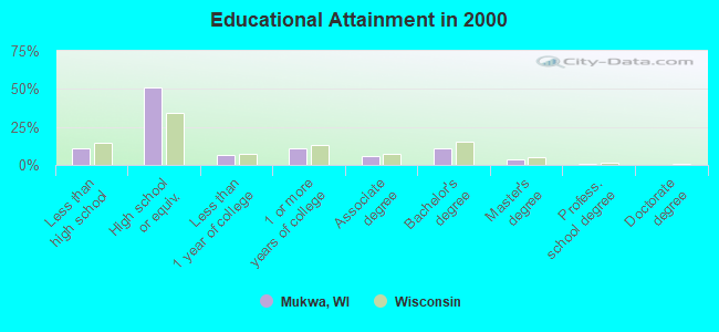
For population 25 years and over in Mukwa:
- High school or higher: 89.2%
- Bachelor's degree or higher: 15.0%
- Graduate or professional degree: 4.3%
- Unemployed: 2.7%
- Mean travel time to work (commute): 23.6 minutes
| Here: | 8.0 |
| Wisconsin average: | 11.0 |
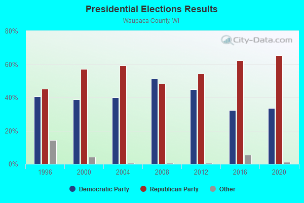
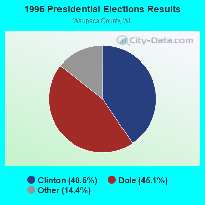
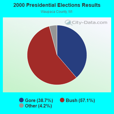

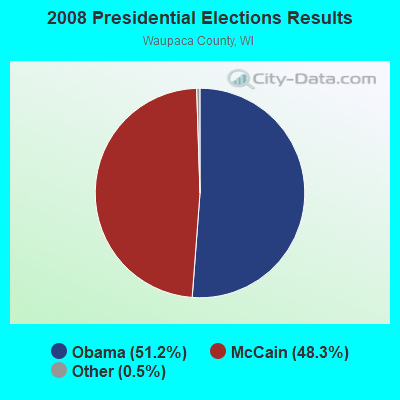
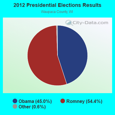


Graphs represent county-level data. Detailed 2008 Election Results
Religion statistics for Mukwa, WI (based on Waupaca County data)
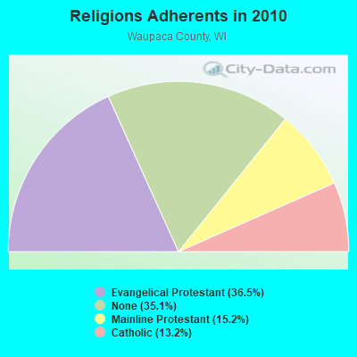
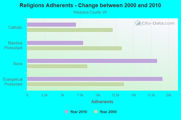
| Religion | Adherents | Congregations |
|---|---|---|
| Evangelical Protestant | 19,152 | 62 |
| Mainline Protestant | 7,941 | 18 |
| Catholic | 6,932 | 7 |
| Other | 9 | 3 |
| None | 18,376 | - |
Food Environment Statistics:
| Waupaca County: | 1.93 / 10,000 pop. |
| Wisconsin: | 1.86 / 10,000 pop. |
| Waupaca County: | 6.35 / 10,000 pop. |
| State: | 4.12 / 10,000 pop. |
| Waupaca County: | 9.63 / 10,000 pop. |
| Wisconsin: | 8.64 / 10,000 pop. |
| Waupaca County: | 7.9% |
| Wisconsin: | 7.6% |
| Waupaca County: | 27.6% |
| Wisconsin: | 27.5% |
| Here: | 11.4% |
| Wisconsin: | 13.0% |
Strongest AM radio stations in Mukwa:
- WNAM (1280 AM; 50 kW; NEENAH-MENASHA, WI; Owner: CUMULUS LICENSING CORP.)
- WHBY (1150 AM; 25 kW; KIMBERLY, WI; Owner: WOODWARD COMMUNICATIONS, INC.)
- WDUX (800 AM; 5 kW; WAUPACA, WI; Owner: LAIRD BROADCASTING COMPANY, INC.)
- WSPT (1010 AM; 50 kW; STEVENS POINT, WI)
- WFCL (1380 AM; 4 kW; CLINTONVILLE, WI; Owner: RESULTS BROADCASTING CORP.)
- WSAU (550 AM; 20 kW; WAUSAU, WI; Owner: WRIG, INC.)
- WTAQ (1360 AM; 10 kW; GREEN BAY, WI; Owner: MIDWEST COMMUNICATIONS, INC.)
- WTMJ (620 AM; 50 kW; MILWAUKEE, WI; Owner: JOURNAL BROADCAST CORPORATION)
- WISN (1130 AM; 50 kW; MILWAUKEE, WI; Owner: CAPSTAR TX LIMITED PARTNERSHIP)
- WRIG (1390 AM; 10 kW; SCHOFIELD, WI; Owner: WRIG, INC.)
- WSCR (670 AM; 50 kW; CHICAGO, IL; Owner: INFINITY BROADCASTING OPERATIONS, INC.)
- WGN (720 AM; 50 kW; CHICAGO, IL; Owner: WGN CONTINENTAL BROADCASTING CO.)
- WTCM (580 AM; 35 kW; TRAVERSE CITY, MI; Owner: WTCM RADIO, INC.)
Strongest FM radio stations in Mukwa:
- WAPL-FM (105.7 FM; APPLETON, WI; Owner: WOODWARD COMMUNICATIONS, INC.)
- WOZZ (93.5 FM; NEW LONDON, WI; Owner: MIDWEST COMMUNICATIONS, INC)
- WJMQ (92.3 FM; CLINTONVILLE, WI; Owner: RESULTS BROADCASTING CORP.)
- WNCY-FM (100.3 FM; NEENAH-MENASHA, WI; Owner: MIDWEST COMMUNICATIONS, INC.)
- WDUX-FM (92.7 FM; WAUPACA, WI; Owner: LAIRD BROADCASTING COMPANY, INC.)
- WIXX (101.1 FM; GREEN BAY, WI; Owner: MIDWEST COMMUNICATIONS, INC.)
- WHID (88.1 FM; GREEN BAY, WI; Owner: BD OF REGENTS OF THE UNIV OF WI SYS)
- WPNE-FM (89.3 FM; GREEN BAY, WI; Owner: WISCONSIN EDUCATIONAL COMMUNICATIONS BOARD)
- WOGB (103.1 FM; KAUKAUNA, WI; Owner: CUMULUS LICENSING CORP.)
- WROE (94.3 FM; NEENAH-MENASHA, WI; Owner: MIDWEST COMMUNICATIONS, INC.)
- WXWX (107.5 FM; BRILLION, WI; Owner: CUMULUS LICENSING CORP.)
- WKSZ (95.9 FM; DE PERE, WI; Owner: WOODWARD COMMUNICATIONS INC)
- WEMI (91.9 FM; APPLETON, WI; Owner: EVANGEL MINISTRIES, INC.)
- WLFM (91.1 FM; APPLETON, WI; Owner: LAWRENCE UNIVERSITY OF WISCONSIN)
- WPCK (104.9 FM; KAUKAUNA, WI; Owner: MIDWEST DIMENSIONS, INC.)
- WECB (104.3 FM; SEYMOUR, WI; Owner: WOODWARD COMMUNICATIONS, INC.)
- WWWX (96.9 FM; OSHKOSH, WI; Owner: CUMULUS LICENSING CORP.)
- WVBO (103.9 FM; WINNECONNE, WI; Owner: CUMULUS LICENSING CORP.)
- W271AC (102.1 FM; APPLETON, WI; Owner: FAMILY EDUC. BROADCASTING CORP.)
TV broadcast stations around Mukwa:
- W66DC (Channel 66; WAUPACA, WI; Owner: TRINITY BROADCASTING NETWORK)
- WMMF-TV (Channel 68; FOND DU LAC, WI; Owner: PAPPAS TELECASTING OF WISCONSIN, A CALIFORNIA LTD PARTNRSHP)
- WBAY-TV (Channel 2; GREEN BAY, WI; Owner: YOUNG BROADCASTING OF GREEN BAY, INC.)
- WLUK-TV (Channel 11; GREEN BAY, WI; Owner: EMMIS TELEVISION LICENSE CORPORATION)
- WFRV-TV (Channel 5; GREEN BAY, WI; Owner: CBS BROADCASTING INC.)
- WIWB (Channel 14; SURING, WI; Owner: ACME TV LICENSES OF WISCONSIN, LLC)
- WPNE (Channel 38; GREEN BAY, WI; Owner: WISCONSIN EDUCATIONAL COMMUNICATIONS BOARD)
- W24BV (Channel 24; WHITING, WI; Owner: MS COMMUNICATIONS, LLC)
- WGBA (Channel 26; GREEN BAY, WI; Owner: ARIES TELECOMMUNICATION CORPORATION)
- WACY (Channel 32; APPLETON, WI; Owner: ACE TV, INC.)
- W23BL (Channel 23; TRAVERSE CITY, MI; Owner: MS COMMUNICATIONS, LLC)
- National Bridge Inventory (NBI) Statistics
- 6Number of bridges
- 79ft / 23.5mTotal length
- $1,486,000Total costs
- 22,525Total average daily traffic
- 623Total average daily truck traffic
- 31,726Total future (year 2038) average daily traffic
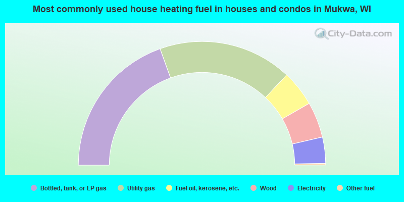
- 39.0%Bottled, tank, or LP gas
- 35.0%Utility gas
- 9.4%Fuel oil, kerosene, etc.
- 9.3%Wood
- 6.9%Electricity
- 0.4%Other fuel
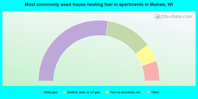
- 54.8%Utility gas
- 25.0%Bottled, tank, or LP gas
- 9.5%Fuel oil, kerosene, etc.
- 3.6%Electricity
- 3.6%Wood
- 3.6%No fuel used
Mukwa compared to Wisconsin state average:
- Unemployed percentage significantly below state average.
- Black race population percentage significantly below state average.
- Hispanic race population percentage significantly below state average.
- Foreign-born population percentage significantly below state average.
- Renting percentage significantly below state average.
- Length of stay since moving in significantly above state average.
- Number of rooms per house significantly below state average.
- House age significantly below state average.
- Number of college students below state average.
- Percentage of population with a bachelor's degree or higher below state average.