Mountainboro, Alabama
Submit your own pictures of this town and show them to the world
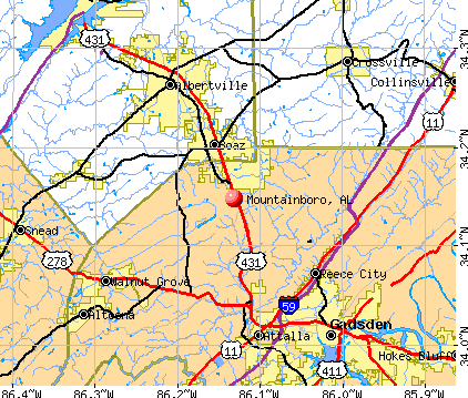
- OSM Map
- General Map
- Google Map
- MSN Map
Population change since 2000: -1.8%
 |
| Males: 160 | |
| Females: 172 |
| Median resident age: | 39.5 years |
| Alabama median age: | 35.8 years |
Zip codes: 35956.
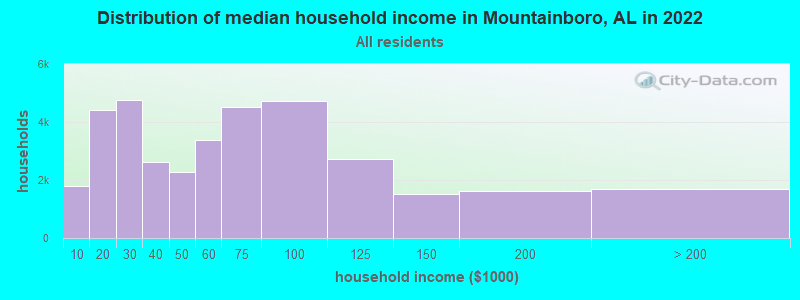
| Mountainboro: | $51,520 |
| AL: | $59,674 |
Estimated per capita income in 2022: $21,785 (it was $12,843 in 2000)
Mountainboro town income, earnings, and wages data
Estimated median house or condo value in 2022: $161,107 (it was $64,000 in 2000)
| Mountainboro: | $161,107 |
| AL: | $200,900 |
Mean prices in 2022: all housing units: $187,963; detached houses: $194,719; townhouses or other attached units: $281,506; in 2-unit structures: $137,818; mobile homes: $100,707; occupied boats, rvs, vans, etc.: $9,829
Detailed information about poverty and poor residents in Mountainboro, AL


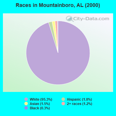
- 32295.3%White alone
- 61.8%Hispanic
- 51.5%Asian alone
- 41.2%Two or more races
- 10.3%Black alone
 Recent articles from our blog. Our writers, many of them Ph.D. graduates or candidates, create easy-to-read articles on a wide variety of topics.

Latest news from Mountainboro, AL collected exclusively by city-data.com from local newspapers, TV, and radio stations
Ancestries: United States (35.5%), Irish (9.5%), English (7.7%), French (2.1%), Polish (1.5%), German (1.2%).
Current Local Time: CST time zone
Elevation: 1109 feet
Land area: 0.81 square miles.
Population density: 411 people per square mile (low).
5 residents are foreign born
| This town: | 1.5% |
| Alabama: | 2.0% |
| Mountainboro town: | 0.4% ($257) |
| Alabama: | 0.4% ($289) |
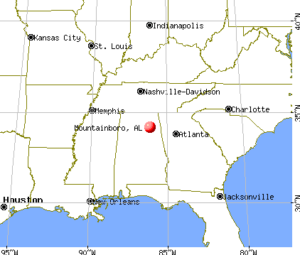
Nearest city with pop. 50,000+: Huntsville, AL  (47.2 miles , pop. 158,216).
Nearest city with pop. 200,000+: Birmingham, AL (58.2 miles , pop. 242,820).
Nearest city with pop. 1,000,000+: Chicago, IL (538.7 miles , pop. 2,896,016).
Nearest cities:
), ), ), ), ), )Latitude: 34.15 N, Longitude: 86.13 W
Area code commonly used in this area: 256
| Here: | 2.9% |
| Alabama: | 2.6% |
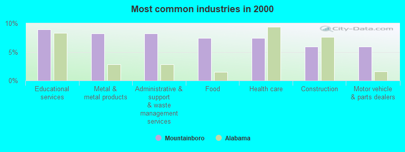
- Educational services (9.0%)
- Metal & metal products (8.2%)
- Administrative & support & waste management services (8.2%)
- Food (7.5%)
- Health care (7.5%)
- Construction (6.0%)
- Motor vehicle & parts dealers (6.0%)
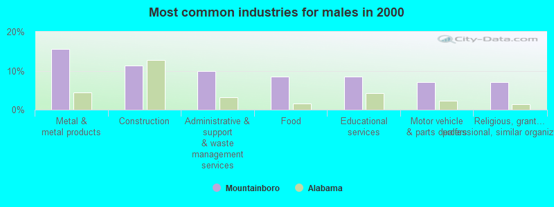
- Metal & metal products (15.5%)
- Construction (11.3%)
- Administrative & support & waste management services (9.9%)
- Food (8.5%)
- Educational services (8.5%)
- Motor vehicle & parts dealers (7.0%)
- Religious, grantmaking, civic, professional, similar organizations (7.0%)
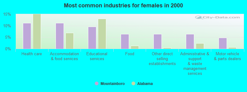
- Health care (11.1%)
- Accommodation & food services (11.1%)
- Educational services (9.5%)
- Food (6.3%)
- Other direct selling establishments (6.3%)
- Administrative & support & waste management services (6.3%)
- Motor vehicle & parts dealers (4.8%)
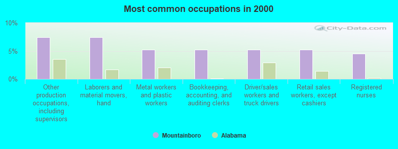
- Other production occupations, including supervisors (7.5%)
- Laborers and material movers, hand (7.5%)
- Metal workers and plastic workers (5.2%)
- Bookkeeping, accounting, and auditing clerks (5.2%)
- Driver/sales workers and truck drivers (5.2%)
- Retail sales workers, except cashiers (5.2%)
- Registered nurses (4.5%)
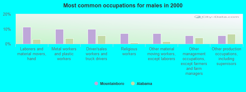
- Laborers and material movers, hand (11.3%)
- Metal workers and plastic workers (9.9%)
- Driver/sales workers and truck drivers (9.9%)
- Religious workers (7.0%)
- Other material moving workers, except laborers (7.0%)
- Other management occupations, except farmers and farm managers (5.6%)
- Other production occupations, including supervisors (5.6%)
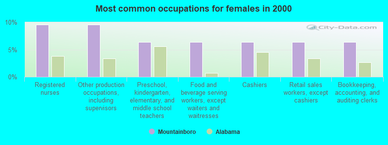
- Registered nurses (9.5%)
- Other production occupations, including supervisors (9.5%)
- Preschool, kindergarten, elementary, and middle school teachers (6.3%)
- Food and beverage serving workers, except waiters and waitresses (6.3%)
- Cashiers (6.3%)
- Retail sales workers, except cashiers (6.3%)
- Bookkeeping, accounting, and auditing clerks (6.3%)
Average climate in Mountainboro, Alabama
Based on data reported by over 4,000 weather stations


(lower is better)
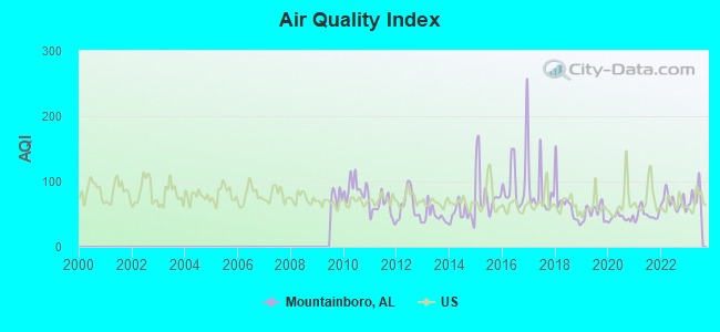
Air Quality Index (AQI) level in 2023 was 74.1. This is about average.
| City: | 74.1 |
| U.S.: | 72.6 |
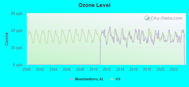
Ozone [ppb] level in 2023 was 35.5. This is about average. Closest monitor was 13.5 miles away from the city center.
| City: | 35.5 |
| U.S.: | 33.3 |
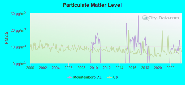
Particulate Matter (PM2.5) [µg/m3] level in 2022 was 8.35. This is about average. Closest monitor was 13.4 miles away from the city center.
| City: | 8.35 |
| U.S.: | 8.11 |
Tornado activity:
Mountainboro-area historical tornado activity is slightly above Alabama state average. It is 156% greater than the overall U.S. average.
On 11/18/1957, a category F4 (max. wind speeds 207-260 mph) tornado 9.9 miles away from the Mountainboro town center killed 3 people and injured 12 people and caused between $50,000 and $500,000 in damages.
On 11/24/2001, a category F4 tornado 12.6 miles away from the town center injured 22 people and caused $1 million in damages.
Earthquake activity:
Mountainboro-area historical earthquake activity is significantly above Alabama state average. It is 125% greater than the overall U.S. average.On 4/29/2003 at 08:59:39, a magnitude 4.9 (4.4 MB, 4.6 MW, 4.9 LG, Class: Light, Intensity: IV - V) earthquake occurred 37.4 miles away from Mountainboro center
On 4/29/2003 at 08:59:39, a magnitude 4.6 (4.6 MW, Depth: 12.3 mi) earthquake occurred 37.4 miles away from Mountainboro center
On 1/18/1999 at 07:00:53, a magnitude 4.8 (4.8 MB, 4.0 LG, Depth: 0.6 mi) earthquake occurred 82.5 miles away from Mountainboro center
On 6/24/1975 at 11:11:36, a magnitude 4.5 (4.5 MB) earthquake occurred 102.4 miles away from Mountainboro center
On 11/30/1973 at 07:48:41, a magnitude 4.7 (4.7 MB, 4.6 ML) earthquake occurred 167.8 miles away from the city center
On 8/2/1974 at 08:52:09, a magnitude 4.9 (4.3 MB, 4.9 LG) earthquake occurred 209.8 miles away from the city center
Magnitude types: regional Lg-wave magnitude (LG), body-wave magnitude (MB), local magnitude (ML), moment magnitude (MW)
Natural disasters:
The number of natural disasters in Etowah County (25) is a lot greater than the US average (15).Major Disasters (Presidential) Declared: 16
Emergencies Declared: 5
Causes of natural disasters: Storms: 14, Tornadoes: 11, Floods: 10, Hurricanes: 4, Winds: 4, Winter Storms: 2, Drought: 1, Fire: 1, Freeze: 1, Snowfall: 1, Other: 1 (Note: some incidents may be assigned to more than one category).
Hospitals and medical centers near Mountainboro:
- GOLDEN LIVING CENTER - BOAZ (Nursing Home, about 6 miles away; BOAZ, AL)
- MOUNTAIN VIEW HOSPITAL (Hospital, about 9 miles away; GADSDEN, AL)
- GADSDEN REGIONAL MEDICAL CENTER HOSPICE (Hospital, about 9 miles away; ATTALLA, AL)
- HOSPICE OF MARSHALL COUNTY/SHEPHERD'S COVE (Hospital, about 10 miles away; ALBERTVILLE, AL)
- GADSDEN REGIONAL HOME HEALTH (Home Health Center, about 11 miles away; ATTALLA, AL)
- ATTALLA HEALTH CARE (Nursing Home, about 12 miles away; ATTALLA, AL)
- ETOWAH COUNTY HOME CARE (Home Health Center, about 12 miles away; GADSDEN, AL)
Colleges/universities with over 2000 students nearest to Mountainboro:
- Snead State Community College (about 5 miles; Boaz, AL; Full-time enrollment: 2,023)
- Gadsden State Community College (about 14 miles; Gadsden, AL; FT enrollment: 4,650)
- Northeast Alabama Community College (about 31 miles; Rainsville, AL; FT enrollment: 2,409)
- Jacksonville State University (about 31 miles; Jacksonville, AL; FT enrollment: 7,566)
- George C Wallace State Community College-Hanceville (about 38 miles; Hanceville, AL; FT enrollment: 4,486)
- Jefferson State Community College (about 48 miles; Birmingham, AL; FT enrollment: 6,041)
- University of Alabama in Huntsville (about 50 miles; Huntsville, AL; FT enrollment: 6,006)
Points of interest:
Notable location: Mountainboro Volunteer Fire Department Station 1 (A). Display/hide its location on the map
Church in Mountainboro: Mountainboro Missionary Baptist Church (A). Display/hide its location on the map
| This town: | 2.6 people |
| Alabama: | 2.5 people |
| This town: | 69.5% |
| Whole state: | 70.4% |
| This town: | 7.8% |
| Whole state: | 3.4% |
Likely homosexual households (counted as self-reported same-sex unmarried-partner households)
- Lesbian couples: 0.8% of all households
- Gay men: 0.8% of all households
| This town: | 19.1% |
| Whole state: | 16.1% |
| This town: | 9.7% |
| Whole state: | 7.3% |
For population 15 years and over in Mountainboro:
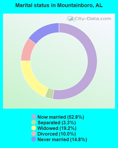
- Never married: 14.8%
- Now married: 52.8%
- Separated: 3.3%
- Widowed: 19.2%
- Divorced: 10.0%
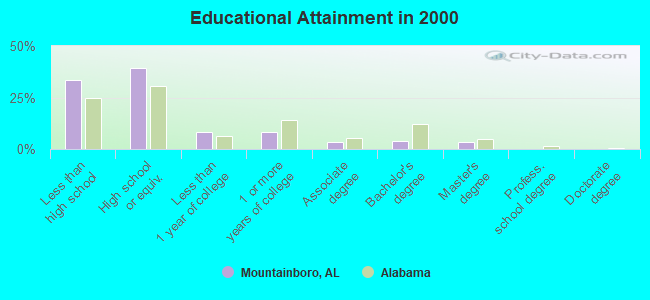
For population 25 years and over in Mountainboro:
- High school or higher: 66.5%
- Bachelor's degree or higher: 7.1%
- Graduate or professional degree: 3.3%
- Unemployed: 6.9%
- Mean travel time to work (commute): 23.6 minutes
| Here: | 15.2 |
| Alabama average: | 13.2 |
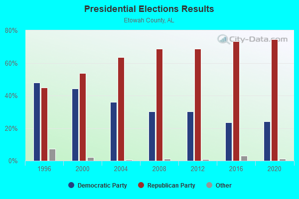
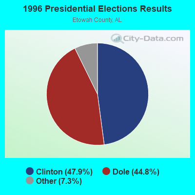
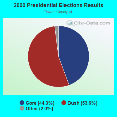
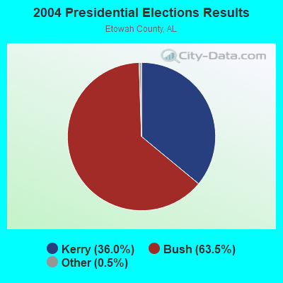
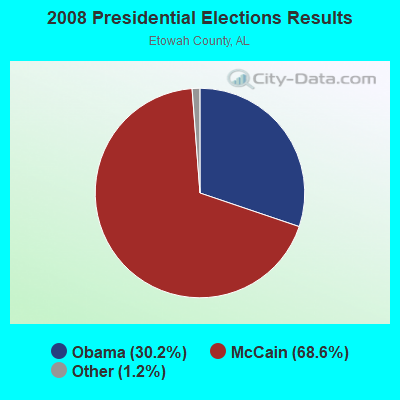

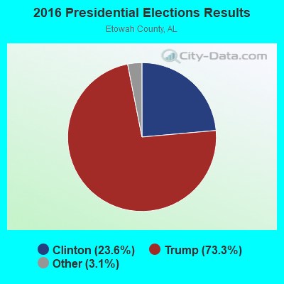
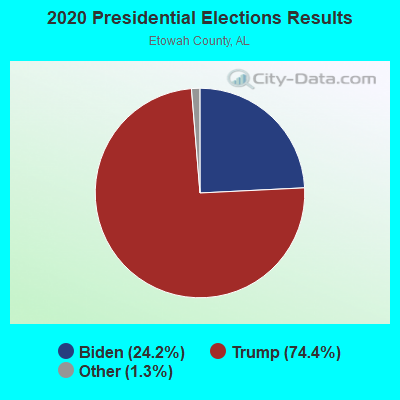
Graphs represent county-level data. Detailed 2008 Election Results
Religion statistics for Mountainboro, AL (based on Etowah County data)
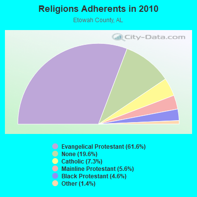
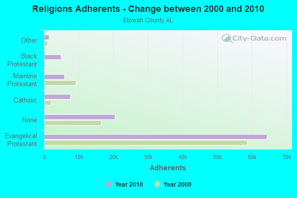
| Religion | Adherents | Congregations |
|---|---|---|
| Evangelical Protestant | 64,316 | 193 |
| Catholic | 7,624 | 1 |
| Mainline Protestant | 5,816 | 35 |
| Black Protestant | 4,813 | 21 |
| Other | 1,437 | 6 |
| None | 20,424 | - |
Food Environment Statistics:
| This county: | 2.43 / 10,000 pop. |
| State: | 1.89 / 10,000 pop. |
| Here: | 0.78 / 10,000 pop. |
| Alabama: | 0.65 / 10,000 pop. |
| This county: | 6.21 / 10,000 pop. |
| State: | 6.32 / 10,000 pop. |
| Etowah County: | 4.95 / 10,000 pop. |
| State: | 5.75 / 10,000 pop. |
| Etowah County: | 10.7% |
| Alabama: | 11.8% |
| Etowah County: | 32.5% |
| State: | 31.7% |
| Here: | 20.2% |
| State: | 13.5% |
| Local government employment and payroll (March 2007) | |||||
| Function | Full-time employees | Monthly full-time payroll | Average yearly full-time wage | Part-time employees | Monthly part-time payroll |
|---|---|---|---|---|---|
| Other Government Administration | 0 | $0 | 9 | $1,280 | |
| Police Protection - Officers | 0 | $0 | 1 | $1,284 | |
| Firefighters | 0 | $0 | 1 | $100 | |
| Totals for Government | 0 | $0 | 11 | $2,664 | |
Mountainboro government finances - Expenditure in 2002 (per resident):
- Current Operations - General - Other: $25,000 ($75.30)
Financial Administration: $10,000 ($30.12)
Fire Protection: $5,000 ($15.06)
Regular Highways: $3,000 ($9.04)
Parks and Recreation: $1,000 ($3.01)
- Other Capital Outlay - Financial Administration: $11,000 ($33.13)
- Total Salaries and Wages: $13,000 ($39.16)
Mountainboro government finances - Revenue in 2002 (per resident):
- Federal Intergovernmental - Other: $10,000 ($30.12)
- Local Intergovernmental - Other: $4,000 ($12.05)
Highways: $1,000 ($3.01)
- Miscellaneous - General Revenue - Other: $2,000 ($6.02)
Interest Earnings: $2,000 ($6.02)
- State Intergovernmental - Other: $6,000 ($18.07)
Highways: $1,000 ($3.01)
- Tax - Property: $21,000 ($63.25)
Public Utilities: $11,000 ($33.13)
Other Selective Sales: $9,000 ($27.11)
Other: $4,000 ($12.05)
Motor Vehicle License: $2,000 ($6.02)
Mountainboro government finances - Cash and Securities in 2002 (per resident):
- Other Funds - Cash and Deposits: $112,000 ($337.35)
Strongest AM radio stations in Mountainboro:
- WNSI (810 AM; 50 kW; JACKSONVILLE, AL; Owner: UNITED BROADCASTING NETWORK, INC.)
- WGAD (1350 AM; 5 kW; GADSDEN, AL; Owner: DEKALB COUNTY COMMUNITY RADIO, INC.)
- WAAX (570 AM; 5 kW; GADSDEN, AL; Owner: CAPSTAR TX LIMITED PARTNERSHIP)
- WBSA (1300 AM; 1 kW; BOAZ, AL; Owner: WATKINS BROADCASTING, INC.)
- WAVU (630 AM; 1 kW; ALBERTVILLE, AL; Owner: SAND MOUNTAIN BROADCASTING SERVICE, INC.)
- WJBY (930 AM; 5 kW; RAINBOW CITY, AL; Owner: GADSDEN BROADCASTING COMPANY, INC.)
- WDJC (850 AM; 50 kW; BIRMINGHAM, AL; Owner: KIMTRON, INC.)
- WJOX (690 AM; 50 kW; BIRMINGHAM, AL; Owner: CITADEL BROADCASTING COMPANY)
- WKNG (1060 AM; daytime; 50 kW; TALLAPOOSA, GA; Owner: WKNG, INC.)
- WAPI (1070 AM; 50 kW; BIRMINGHAM, AL; Owner: CITADEL BROADCASTING COMPANY)
- WWAM (820 AM; daytime; 50 kW; JASPER, TN; Owner: SHELTON BROADCASTING SYSTEM)
- WLOR (1550 AM; 50 kW; HUNTSVILLE, AL; Owner: BCA RADIO, LLC)
- WFLI (1070 AM; 50 kW; LOOKOUT MOUNTAIN, TN; Owner: WFLI, INC.)
Strongest FM radio stations in Mountainboro:
- WQSB (105.1 FM; ALBERTVILLE, AL; Owner: SAND MOUNTAIN BROADCASTING SERVICE, INC.)
- WSGN (91.5 FM; GADSDEN, AL; Owner: GADSDEN STATE COMMUNITY COLLEGE)
- WTBB (89.9 FM; GADSDEN, AL; Owner: TRINITY CHRISTIAN ACADEMY)
- WKXX (102.9 FM; ATTALLA, AL; Owner: BROADCAST MEDIA LLC)
- WRHY (105.9 FM; CENTRE, AL; Owner: WILLIAMS COMMUNICATIONS, INC.)
- WTWX-FM (95.9 FM; GUNTERSVILLE, AL; Owner: GUNTERSVILLE BROADCASTING CO., INC.)
- WGMZ (93.1 FM; GLENCOE, AL; Owner: CAPSTAR TX LIMITED PARTNERSHIP)
- WAFN-FM (92.7 FM; ARAB, AL; Owner: FUN MEDIA GROUP, INC.)
- WLJS-FM (91.9 FM; JACKSONVILLE, AL; Owner: BD. OF TRUSTEES/JACKSONVILLE STATE UNIVERSITY)
- WTBJ (91.3 FM; OXFORD, AL; Owner: TRINITY CHRISTIAN ACADEMY)
- WRAX (107.7 FM; BIRMINGHAM, AL; Owner: CITADEL BROADCASTING COMPANY)
- WYDE-FM (101.1 FM; CULLMAN, AL; Owner: KIMTRON, INC.)
- WRSA-FM (96.9 FM; DECATUR, AL; Owner: NCA, INC.)
- WVOK-FM (97.9 FM; OXFORD, AL; Owner: WOODARD BROADCASTING CO. INC.)
- WAHR (99.1 FM; HUNTSVILLE, AL; Owner: BCA RADIO, LLC)
- W289AC (105.7 FM; HUNTSVILLE, AL; Owner: WILLIAM PAXTON ROGERS)
- WJIA (88.5 FM; GUNTERSVILLE, AL; Owner: LAKE CITY EDUCATIONAL B/CASTING INC.)
- W298AF (107.5 FM; HADEN, AL; Owner: HADEN RADIO COMPANY)
- WXQW (94.1 FM; MERIDIANVILLE, AL; Owner: CAPSTAR TX LIMITED PARTNERSHIP)
- W293AH (106.5 FM; NORMAL, AL; Owner: CAPSTAR TX LIMITED PARTNERSHIP)
TV broadcast stations around Mountainboro:
- WPXH (Channel 44; GADSDEN, AL; Owner: PAXSON COMMUNICATIONS LICENSE COMPANY, LLC)
- WZDX (Channel 54; HUNTSVILLE, AL; Owner: HUNTSVILLE TELEVISION ACQUISITION CORP.)
- W64BJ (Channel 64; SCOTTSBORO, AL; Owner: TRINITY BROADCASTING NETWORK)
- WTJP (Channel 60; GADSDEN, AL; Owner: TRINITY BROADCASTING NETWORK)
- W15AP (Channel 15; GADSDEN, AL; Owner: WBRC LICENSE, INC.)
- Mountainboro, Alabama
- Fatal accident count10
- Vehicles involved in fatal accidents20
- Fatal accidents involving drunk persons:1
- Fatalities10
- Persons involved in fatal accidents32
- Pedestrians involved in fatal accidents0
- Alabama average
- Fatal accident count7523
- Vehicles involved in fatal accidents11496
- Fatal accidents involving drunk persons1946
- Fatalities8393
- Persons involved in fatal accidents17962
- Pedestrians involved in fatal accidents934
FCC Registered Cell Phone Towers:
1 (See the full list of FCC Registered Cell Phone Towers in Mountainboro)FCC Registered Antenna Towers:
14 (See the full list of FCC Registered Antenna Towers)FCC Registered Microwave Towers:
2- Mountainboro, 693 Hightower Road (Lat: 34.147500 Lon: -86.182778), Type: Mtower, Structure height: 86.8 m, Overall height: 94.4 m, Call Sign: WQHR229,
Assigned Frequencies: 11245.0 MHz, 11325.0 MHz, 11245.0 MHz, 11325.0 MHz, 11245.0 MHz, 11325.0 MHz, 11245.0 MHz, 11325.0 MHz, 11245.0 MHz, 11325.0 MHz... (+16 more), Grant Date: 09/06/2017, Expiration Date: 10/11/2027, Certifier: Pamelia Y Hoof, Registrant: Verizon Wireless, 5055 North Point Pkwy, Np2ne Network Engineering, Alpharetta, GA 30022, Phone: (770) 797-1070, Email:
- AG MOUNTAINB, 693 Fire Tower Rd (Lat: 34.147500 Lon: -86.182778), Type: Mast, Structure height: 86.8 m, Overall height: 94.4 m, Call Sign: WQPT210,
Assigned Frequencies: 11285.0 MHz, Grant Date: 08/02/2022, Expiration Date: 08/08/2032, Certifier: Chris Harris, Registrant: Conterra Ultra Broadband, LLC, 2101 Rexford Rd, Ste 200e, Charlotte, NC 28211, Phone: (704) 936-1801, Fax: (704) 936-1801, Email:
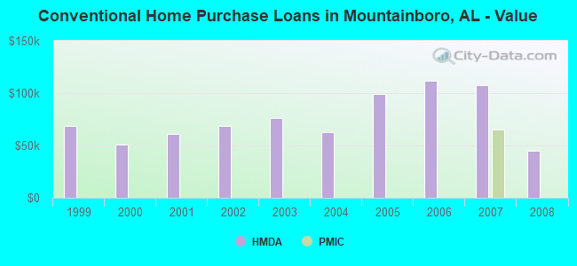
| Home Mortgage Disclosure Act Aggregated Statistics For Year 2009 (Based on 1 partial tract) | ||
| C) Refinancings | ||
|---|---|---|
| Number | Average Value | |
| LOANS ORIGINATED | 2 | $108,265 |
| APPLICATIONS APPROVED, NOT ACCEPTED | 0 | $0 |
| APPLICATIONS DENIED | 1 | $78,900 |
| APPLICATIONS WITHDRAWN | 0 | $0 |
| FILES CLOSED FOR INCOMPLETENESS | 0 | $0 |
Detailed HMDA statistics for the following Tracts: 0110.00
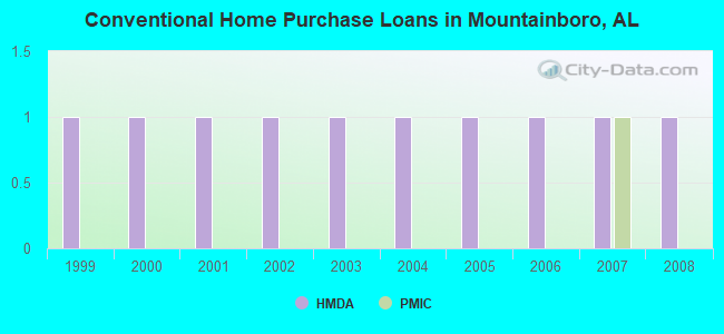
| Private Mortgage Insurance Companies Aggregated Statistics For Year 2007 (Based on 1 partial tract) | ||
| A) Conventional Home Purchase Loans | ||
|---|---|---|
| Number | Average Value | |
| LOANS ORIGINATED | 1 | $65,600 |
| APPLICATIONS APPROVED, NOT ACCEPTED | 0 | $0 |
| APPLICATIONS DENIED | 0 | $0 |
| APPLICATIONS WITHDRAWN | 0 | $0 |
| FILES CLOSED FOR INCOMPLETENESS | 0 | $0 |
Detailed PMIC statistics for the following Tracts: 0110.00
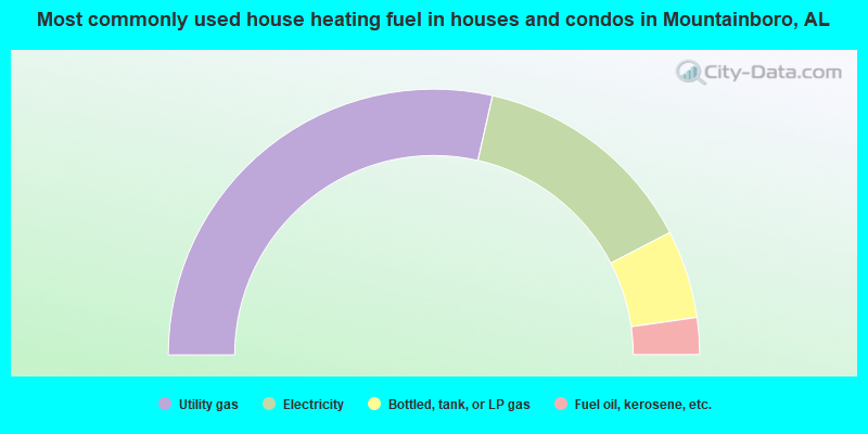
- 57.1%Utility gas
- 27.7%Electricity
- 10.7%Bottled, tank, or LP gas
- 4.5%Fuel oil, kerosene, etc.
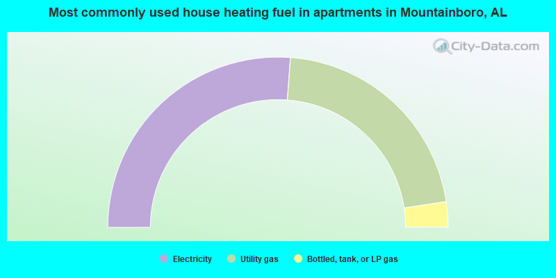
- 52.4%Electricity
- 42.9%Utility gas
- 4.8%Bottled, tank, or LP gas
Mountainboro compared to Alabama state average:
- Unemployed percentage below state average.
- Black race population percentage significantly below state average.
- Hispanic race population percentage below state average.
- Foreign-born population percentage significantly below state average.
- Renting percentage significantly below state average.
- Length of stay since moving in significantly above state average.
- Number of rooms per house significantly below state average.
- House age significantly below state average.
- Number of college students below state average.
- Percentage of population with a bachelor's degree or higher significantly below state average.