Mount Chase, Maine
Submit your own pictures of this town and show them to the world
- OSM Map
- Google Map
- MSN Map
Population change since 2000: -18.6%
 |
| Males: 111 | |
| Females: 90 |
| Median resident age: | 50.1 years |
| Maine median age: | 43.0 years |
Zip codes: 04765.
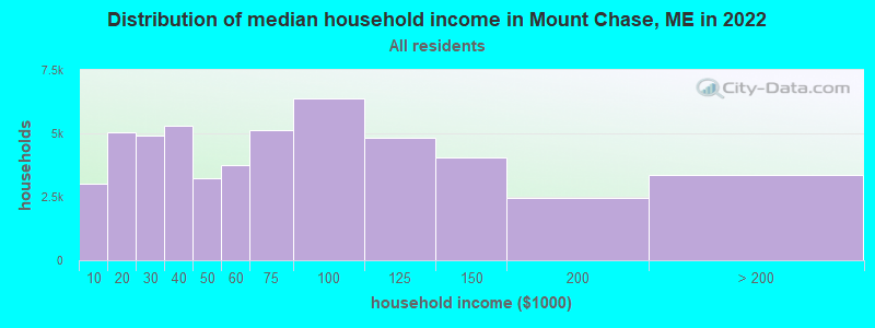
| Mount Chase: | $47,633 |
| ME: | $69,543 |
Estimated per capita income in 2022: $25,993 (it was $12,930 in 2000)
Mount Chase town income, earnings, and wages data
Estimated median house or condo value in 2022: $170,175 (it was $65,400 in 2000)
| Mount Chase: | $170,175 |
| ME: | $290,600 |
Mean prices in 2022: all housing units: $235,563; detached houses: $252,705; townhouses or other attached units: $267,749; in 2-unit structures: $255,332; in 3-to-4-unit structures: $815,300; in 5-or-more-unit structures: $185,873; mobile homes: $93,017; occupied boats, rvs, vans, etc.: $21,333
Detailed information about poverty and poor residents in Mount Chase, ME


- 19295.5%White alone
- 63.0%Asian alone
- 10.5%Black alone
- 10.5%Two or more races
- 10.5%Hispanic
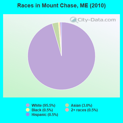
Races in Mount Chase detailed stats: ancestries, foreign born residents, place of birth
According to our research of Maine and other state lists, there was 1 registered sex offender living in Mount Chase, Maine as of May 09, 2024.
The ratio of all residents to sex offenders in Mount Chase is 201 to 1.
 Recent articles from our blog. Our writers, many of them Ph.D. graduates or candidates, create easy-to-read articles on a wide variety of topics.
Ancestries: French (22.3%), Irish (20.6%), English (19.4%), German (9.3%), Scottish (8.5%), Swedish (6.1%).
Current Local Time: EST time zone
Land area: 36.3 square miles.
Population density: 5.5 people per square mile (very low).
| Mount Chase town: | 1.0% ($646) |
| Maine: | 1.5% ($1,417) |
Nearest city with pop. 50,000+: Portland, ME  (186.6 miles , pop. 64,249).
Nearest city with pop. 200,000+: Boston, MA (288.3 miles , pop. 589,141).
Nearest city with pop. 1,000,000+: Bronx, NY (449.6 miles , pop. 1,332,650).
Nearest cities:
Latitude: 46.06 N, Longitude: 68.52 W
Area code commonly used in this area: 207
| Here: | 16.1% |
| Maine: | 3.4% |
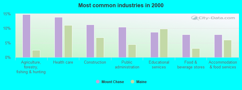
- Agriculture, forestry, fishing & hunting (14.8%)
- Health care (13.9%)
- Construction (11.3%)
- Public administration (10.4%)
- Educational services (8.7%)
- Food & beverage stores (7.8%)
- Accommodation & food services (7.8%)
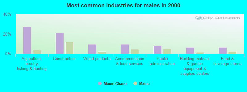
- Agriculture, forestry, fishing & hunting (27.4%)
- Construction (21.0%)
- Wood products (9.7%)
- Accommodation & food services (9.7%)
- Public administration (8.1%)
- Building material & garden equipment & supplies dealers (6.5%)
- Food & beverage stores (6.5%)
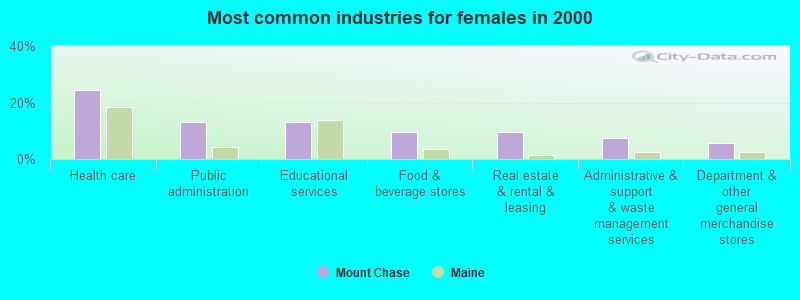
- Health care (24.5%)
- Public administration (13.2%)
- Educational services (13.2%)
- Food & beverage stores (9.4%)
- Real estate & rental & leasing (9.4%)
- Administrative & support & waste management services (7.5%)
- Department & other general merchandise stores (5.7%)
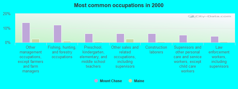
- Other management occupations, except farmers and farm managers (13.9%)
- Fishing, hunting, and forestry occupations (12.2%)
- Preschool, kindergarten, elementary, and middle school teachers (6.1%)
- Other sales and related occupations, including supervisors (6.1%)
- Construction laborers (6.1%)
- Supervisors and other personal care and service workers, except child care workers (5.2%)
- Law enforcement workers, including supervisors (4.3%)
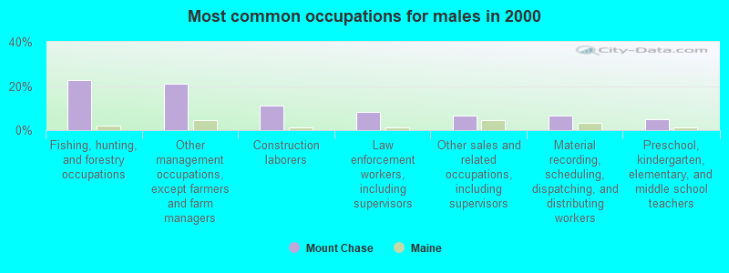
- Fishing, hunting, and forestry occupations (22.6%)
- Other management occupations, except farmers and farm managers (21.0%)
- Construction laborers (11.3%)
- Law enforcement workers, including supervisors (8.1%)
- Other sales and related occupations, including supervisors (6.5%)
- Material recording, scheduling, dispatching, and distributing workers (6.5%)
- Preschool, kindergarten, elementary, and middle school teachers (4.8%)
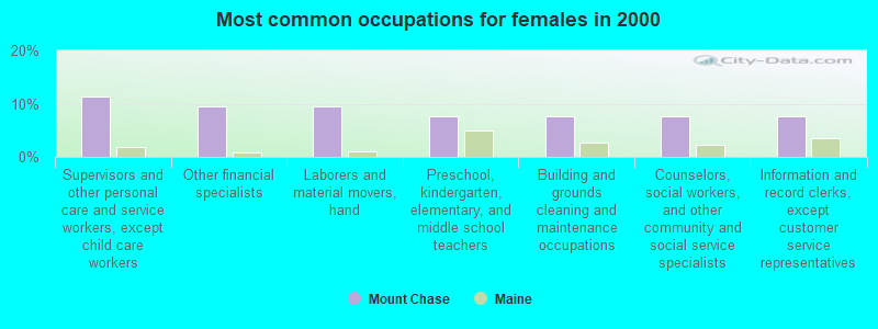
- Supervisors and other personal care and service workers, except child care workers (11.3%)
- Other financial specialists (9.4%)
- Laborers and material movers, hand (9.4%)
- Preschool, kindergarten, elementary, and middle school teachers (7.5%)
- Building and grounds cleaning and maintenance occupations (7.5%)
- Counselors, social workers, and other community and social service specialists (7.5%)
- Information and record clerks, except customer service representatives (7.5%)
Average climate in Mount Chase, Maine
Based on data reported by over 4,000 weather stations


Earthquake activity:
Mount Chase-area historical earthquake activity is significantly above Maine state average. It is 84% smaller than the overall U.S. average.On 4/20/2002 at 10:50:47, a magnitude 5.3 (5.3 ML, Depth: 3.0 mi, Class: Moderate, Intensity: VI - VII) earthquake occurred 273.8 miles away from Mount Chase center
On 4/20/2002 at 10:50:47, a magnitude 5.2 (5.2 MB, 4.2 MS, 5.2 MW, 5.0 MW) earthquake occurred 275.4 miles away from the city center
On 10/16/2012 at 23:12:25, a magnitude 4.7 (4.7 ML, Depth: 10.0 mi, Class: Light, Intensity: IV - V) earthquake occurred 200.0 miles away from Mount Chase center
On 10/7/1983 at 10:18:46, a magnitude 5.3 (5.1 MB, 5.3 LG, 5.1 ML) earthquake occurred 319.8 miles away from the city center
On 7/14/2006 at 09:34:48, a magnitude 3.9 (3.9 MD, Depth: 8.6 mi, Class: Light, Intensity: II - III) earthquake occurred 57.0 miles away from Mount Chase center
On 1/19/1982 at 00:14:42, a magnitude 4.7 (4.5 MB, 4.7 MD, 4.5 LG) earthquake occurred 232.9 miles away from Mount Chase center
Magnitude types: regional Lg-wave magnitude (LG), body-wave magnitude (MB), duration magnitude (MD), local magnitude (ML), surface-wave magnitude (MS), moment magnitude (MW)
Natural disasters:
The number of natural disasters in Penobscot County (19) is greater than the US average (15).Major Disasters (Presidential) Declared: 11
Emergencies Declared: 7
Causes of natural disasters: Floods: 9, Storms: 8, Snows: 5, Heavy Rains: 2, Blizzard: 1, Hurricane: 1, Ice Storm: 1, Snowfall: 1, Wind: 1, Winter Storm: 1, Other: 2 (Note: some incidents may be assigned to more than one category).
Colleges/universities with over 2000 students nearest to Mount Chase:
- University of Maine (about 81 miles; Orono, ME; Full-time enrollment: 8,931)
- Husson University (about 87 miles; Bangor, ME; FT enrollment: 2,421)
- University of Maine at Farmington (about 125 miles; Farmington, ME; FT enrollment: 2,036)
- University of Maine at Augusta (about 135 miles; Augusta, ME; FT enrollment: 3,204)
- Saint Joseph's College of Maine (about 182 miles; Standish, ME; FT enrollment: 2,010)
- Southern Maine Community College (about 187 miles; South Portland, ME; FT enrollment: 4,666)
- University of Southern Maine (about 187 miles; Portland, ME; FT enrollment: 6,647)
Points of interest:
Notable location: Shin Pond Village Campground (A). Display/hide its location on the map
Lakes: Ackley Pond (A), Upper Shin Pond (B). Display/hide their locations on the map
Streams, rivers, and creeks: Sargent Brook (A), Willett Brook (B). Display/hide their locations on the map
| This town: | 2.1 people |
| Maine: | 2.3 people |
| This town: | 60.6% |
| Whole state: | 62.9% |
| This town: | 5.3% |
| Whole state: | 9.4% |
No gay or lesbian households reported
| This town: | 27.4% |
| Whole state: | 10.9% |
| This town: | 3.6% |
| Whole state: | 4.1% |
For population 15 years and over in Mount Chase:
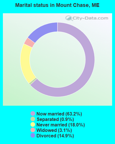
- Never married: 18.0%
- Now married: 63.2%
- Separated: 0.9%
- Widowed: 3.1%
- Divorced: 14.9%
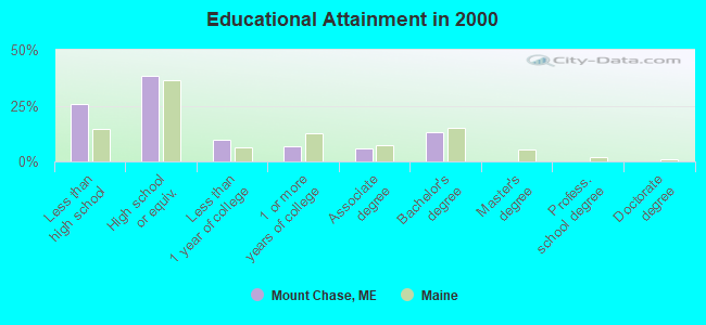
For population 25 years and over in Mount Chase:
- High school or higher: 74.1%
- Bachelor's degree or higher: 13.0%
- Graduate or professional degree: 0.0%
- Unemployed: 9.4%
- Mean travel time to work (commute): 26.6 minutes
| Here: | 9.0 |
| Maine average: | 11.2 |


Graphs represent county-level data. Detailed 2008 Election Results
Religion statistics for Mount Chase, ME (based on Penobscot County data)


| Religion | Adherents | Congregations |
|---|---|---|
| Catholic | 16,581 | 15 |
| Mainline Protestant | 9,715 | 59 |
| Evangelical Protestant | 7,523 | 80 |
| Other | 2,936 | 22 |
| Orthodox | 300 | 1 |
| None | 116,868 | - |
Food Environment Statistics:
| Here: | 2.29 / 10,000 pop. |
| Maine: | 2.80 / 10,000 pop. |
| Here: | 0.13 / 10,000 pop. |
| Maine: | 0.14 / 10,000 pop. |
| Penobscot County: | 2.56 / 10,000 pop. |
| Maine: | 2.20 / 10,000 pop. |
| Here: | 5.72 / 10,000 pop. |
| State: | 5.75 / 10,000 pop. |
| Penobscot County: | 7.41 / 10,000 pop. |
| State: | 11.02 / 10,000 pop. |
| This county: | 9.0% |
| Maine: | 8.2% |
| This county: | 28.0% |
| Maine: | 25.0% |
Strongest AM radio stations in Mount Chase:
- WREM (710 AM; daytime; 5 kW; MONTICELLO, ME; Owner: ALLAN H WEINER)
- WFST (600 AM; 5 kW; CARIBOU, ME; Owner: NORTHERN BROADCAST MINISTRIES, INC.)
- WEGP (1390 AM; 5 kW; PRESQUE ISLE, ME; Owner: DECELLES/SMITH MEDIA, INC.)
- WZON (620 AM; 5 kW; BANGOR, ME; Owner: THE ZONE CORPORATION)
- WSYY (1240 AM; 1 kW; MILLINOCKET, ME; Owner: KATAHDIN BROADCASTING, INC.)
- WRKO (680 AM; 50 kW; BOSTON, MA; Owner: ENTERCOM BOSTON LICENSE, LLC)
- WSKW (1160 AM; 10 kW; SKOWHEGAN, ME; Owner: MOUNTAIN WIRELESS, INCORPORATED)
- WCHP (760 AM; 35 kW; CHAMPLAIN, NY; Owner: CHAMPLAIN RADIO, INC.)
- WABI (910 AM; 5 kW; BANGOR, ME; Owner: CLEAR CHANNEL BROADCASTING LICENSES, INC.)
- WEEI (850 AM; 50 kW; BOSTON, MA; Owner: ENTERCOM BOSTON LICENSE, LLC)
- WNNZ (640 AM; 50 kW; WESTFIELD, MA; Owner: CLEAR CHANNEL BROADCASTING LICENSES, INC.)
- WCRN (830 AM; 50 kW; WORCESTER, MA; Owner: CARTER BROADCASTING CORPORATION)
- WTME (780 AM; 10 kW; RUMFORD, ME; Owner: MOUNTAIN VALLEY BROADCASTING, INC.)
Strongest FM radio stations in Mount Chase:
- WHOU-FM (100.1 FM; HOULTON, ME; Owner: COUNTY COMMUNICATIONS, INC.)
- WSYY-FM (94.9 FM; MILLINOCKET, ME; Owner: KATAHDIN COMMUNICATIONS, INC.)
- WQHR (96.1 FM; PRESQUE ISLE, ME; Owner: CITADEL BROADCASTING COMPANY)
- WOZI (101.9 FM; PRESQUE ISLE, ME; Owner: CITADEL BROADCASTING COMPANY)
- National Bridge Inventory (NBI) Statistics
- 3Number of bridges
- 10ft / 3.1mTotal length
- 1,494Total average daily traffic
- 73Total average daily truck traffic
- 2,390Total future (year 2036) average daily traffic
FCC Registered Amateur Radio Licenses:
3- Call Sign: WA1UDP, Licensee ID: L00244831, Grant Date: 05/02/2006, Expiration Date: 07/18/2016, Cancellation Date: 07/19/2018, Certifier: Phillip J Hunter, Registrant: Phillip J Hunter, 1030 Shin Pond Road, Mount Chase, ME 04765
- Call Sign: KK4HJS, Licensee ID: L01693655, Grant Date: 11/30/2022, Expiration Date: 11/30/2032, Certifier: Marc D Terry, Registrant: Marc D Terry, 927 Shin Pond Rd, Mount Chase, ME 04765
- Call Sign: KC1MJL, Licensee ID: L02313442, Grant Date: 12/20/2019, Expiration Date: 12/20/2029, Certifier: Eddy B Collins, Registrant: Eddy B Collins, 719 North Road, Mount Chase, ME 04765
FAA Registered Aircraft:
3- Aircraft: ENGROFF RICHARD L TEAM HI-MAX (Category: Land, Weight: Up to 12,499 Pounds), Engine: BOMBARDIER ROTAX (ALL) (Reciprocating)
N-Number: 745DE, N745DE, N-745DE, Serial Number: 983, Year manufactured: 2000, Airworthiness Date: 06/20/2000, Certificate Issue Date: 06/09/1999
Registrant (Individual): Richard L Engroff, 20 Wapiti Rd, Mount Chase, ME 04765 - Aircraft: AERONCA 7CCM (Category: Land, Seats: 2, Weight: Up to 12,499 Pounds, Speed: 90 mph), Engine: CONT MOTOR C90 SERIES (95 HP) (Reciprocating)
N-Number: 84244, N84244, N-84244, Serial Number: 7AC-2936, Year manufactured: 1946, Airworthiness Date: 05/09/1995, Certificate Issue Date: 07/19/2005
Registrant (Co-Owned): Richard L Engroff, 20 Wapiti Rd, Mount Chase, ME 04765, Other Owners: Margaret E Engroff - Aircraft: OMF OMF-100-160 (Category: Land, Seats: 2, Weight: Up to 12,499 Pounds), Engine: Reciprocating
N-Number: 883SA, N883SA, N-883SA, Serial Number: 0034
Registrant (Individual): Reported Sale, 170 W Shore Rd, Mount Chase, ME 04765
Mount Chase compared to Maine state average:
- Median house value below state average.
- Black race population percentage significantly below state average.
- Hispanic race population percentage significantly below state average.
- Median age above state average.
- Foreign-born population percentage significantly below state average.
- Renting percentage significantly below state average.
- Length of stay since moving in significantly above state average.
- Number of rooms per house significantly below state average.
- House age significantly below state average.
- Number of college students significantly below state average.
- Percentage of population with a bachelor's degree or higher below state average.
State forum archive: