Morristown, Vermont

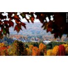
Submit your own pictures of this town and show them to the world
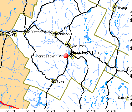
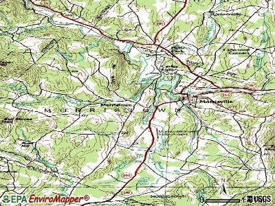
- OSM Map
- General Map
- Google Map
- MSN Map
Population change since 2000: +1.7%
 |
| Males: 2,510 | |
| Females: 2,717 |
| Median resident age: | 41.9 years |
| Vermont median age: | 45.8 years |
Zip codes: 05661.
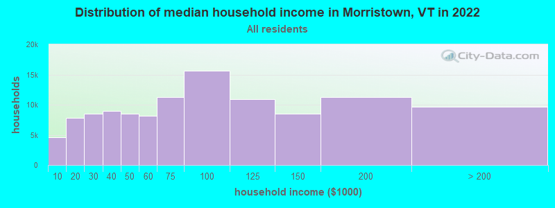
| Morristown: | $59,218 |
| VT: | $73,991 |
Estimated per capita income in 2022: $35,554 (it was $17,195 in 2000)
Morristown town income, earnings, and wages data
Estimated median house or condo value in 2022: $289,829 (it was $109,500 in 2000)
| Morristown: | $289,829 |
| VT: | $304,700 |
Detailed information about poverty and poor residents in Morristown, VT


- 4,99195.5%White alone
- 771.5%Two or more races
- 751.4%Hispanic
- 360.7%Black alone
- 320.6%Asian alone
- 130.2%American Indian alone
- 30.06%Other race alone
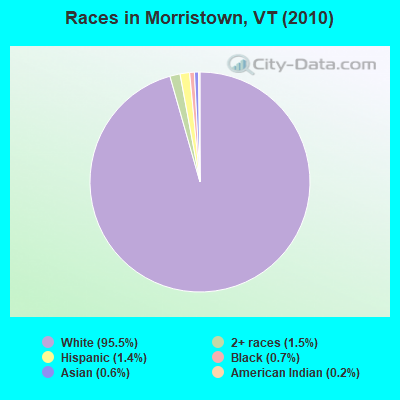
Races in Morristown detailed stats: ancestries, foreign born residents, place of birth
Type |
2009 |
2010 |
2011 |
2012 |
2013 |
2014 |
2015 |
2016 |
2017 |
2018 |
2019 |
2020 |
2021 |
2022 |
|---|---|---|---|---|---|---|---|---|---|---|---|---|---|---|
| Murders (per 100,000) | 0 (0.0) | 0 (0.0) | 0 (0.0) | 0 (0.0) | 0 (0.0) | 0 (0.0) | 0 (0.0) | 0 (0.0) | 0 (0.0) | 0 (0.0) | 0 (0.0) | 0 (0.0) | 0 (0.0) | 0 (0.0) |
| Rapes (per 100,000) | 0 (0.0) | 0 (0.0) | 0 (0.0) | 0 (0.0) | 0 (0.0) | 0 (0.0) | 1 (18.4) | 0 (0.0) | 1 (18.3) | 4 (73.4) | 7 (128.1) | 1 (18.1) | 7 (125.4) | 2 (35.7) |
| Robberies (per 100,000) | 1 (17.8) | 0 (0.0) | 0 (0.0) | 0 (0.0) | 1 (18.6) | 0 (0.0) | 0 (0.0) | 0 (0.0) | 1 (18.3) | 1 (18.3) | 0 (0.0) | 1 (18.1) | 1 (17.9) | 0 (0.0) |
| Assaults (per 100,000) | 6 (107.0) | 4 (76.5) | 5 (95.5) | 9 (170.7) | 0 (0.0) | 1 (18.4) | 5 (92.1) | 4 (73.4) | 4 (73.1) | 2 (36.7) | 7 (128.1) | 11 (198.8) | 7 (125.4) | 5 (89.1) |
| Burglaries (per 100,000) | 17 (303.2) | 12 (229.6) | 16 (305.8) | 13 (246.5) | 16 (298.0) | 2 (36.8) | 8 (147.4) | 3 (55.0) | 2 (36.5) | 5 (91.7) | 10 (183.0) | 5 (90.4) | 8 (143.3) | 2 (35.7) |
| Thefts (per 100,000) | 102 (1,819) | 60 (1,148) | 89 (1,701) | 82 (1,555) | 85 (1,583) | 20 (368.1) | 65 (1,197) | 47 (862.1) | 71 (1,297) | 72 (1,321) | 114 (2,086) | 77 (1,392) | 82 (1,469) | 86 (1,533) |
| Auto thefts (per 100,000) | 4 (71.4) | 1 (19.1) | 1 (19.1) | 4 (75.9) | 0 (0.0) | 0 (0.0) | 0 (0.0) | 0 (0.0) | 0 (0.0) | 0 (0.0) | 0 (0.0) | 2 (36.2) | 0 (0.0) | 0 (0.0) |
| Arson (per 100,000) | 0 (0.0) | 0 (0.0) | 0 (0.0) | 0 (0.0) | 0 (0.0) | 0 (0.0) | 1 (18.4) | 0 (0.0) | 0 (0.0) | 0 (0.0) | 1 (18.3) | 0 (0.0) | 0 (0.0) | 2 (35.7) |
| City-Data.com crime index | 126.5 | 78.8 | 110.1 | 119.7 | 89.8 | 21.0 | 91.4 | 53.0 | 89.1 | 130.8 | 224.3 | 124.5 | 199.6 | 110.2 |
The City-Data.com crime index weighs serious crimes and violent crimes more heavily. Higher means more crime, U.S. average is 246.1. It adjusts for the number of visitors and daily workers commuting into cities.
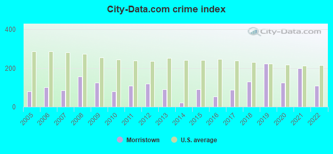
Crime rate in Morristown detailed stats: murders, rapes, robberies, assaults, burglaries, thefts, arson
Full-time law enforcement employees in 2021, including police officers: 9 (9 officers - 9 male; 0 female).
| Officers per 1,000 residents here: | 1.61 |
| Vermont average: | 1.69 |
 Recent articles from our blog. Our writers, many of them Ph.D. graduates or candidates, create easy-to-read articles on a wide variety of topics.

 | Communities or not? (43 replies) |
| Vermont Retirement Planning: Tell me what I DON'T know about Vermont (95 replies) |
| Craftsbury, VT (0 replies) |
| Newbury, VT (9 replies) |
| If you moved to VT from another place, let us know what your experience was here (161 replies) |
| Yet another moving to Vermont thread - Burlington or Montpelier area (27 replies) |
Latest news from Morristown, VT collected exclusively by city-data.com from local newspapers, TV, and radio stations
Ancestries: English (16.8%), French (13.1%), Irish (12.4%), French Canadian (9.3%), United States (8.6%), German (8.2%).
Current Local Time: EST time zone
Elevation: 759 feet
Land area: 51.4 square miles.
Population density: 102 people per square mile (very low).
119 residents are foreign born (1.1% North America, 1.0% Europe).
| This town: | 2.3% |
| Vermont: | 3.8% |
| Morristown town: | 1.7% ($1,882) |
| Vermont: | 2.0% ($2,196) |
Nearest city with pop. 50,000+: Manchester, NH  (122.8 miles , pop. 107,006).
Nearest city with pop. 200,000+: Boston, MA (172.2 miles , pop. 589,141).
Nearest city with pop. 1,000,000+: Bronx, NY (264.3 miles , pop. 1,332,650).
Nearest cities:
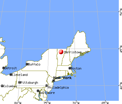
), ), ), ), )Latitude: 44.55 N, Longitude: 72.61 W
Area code commonly used in this area: 802

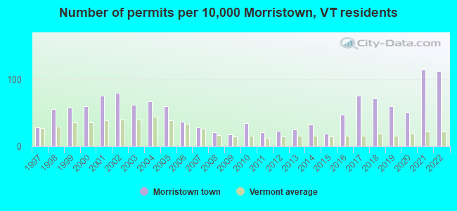
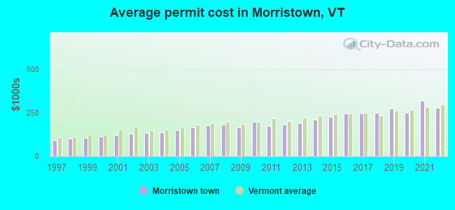
Single-family new house construction building permits:
- 2022: 58 buildings, average cost: $277,800
- 2021: 59 buildings, average cost: $318,500
- 2020: 26 buildings, average cost: $252,100
- 2019: 31 buildings, average cost: $272,800
- 2018: 37 buildings, average cost: $249,700
- 2017: 39 buildings, average cost: $247,800
- 2016: 24 buildings, average cost: $245,200
- 2015: 10 buildings, average cost: $226,800
- 2014: 17 buildings, average cost: $209,100
- 2013: 13 buildings, average cost: $191,800
- 2012: 12 buildings, average cost: $183,100
- 2011: 11 buildings, average cost: $172,200
- 2010: 18 buildings, average cost: $200,000
- 2009: 9 buildings, average cost: $165,100
- 2008: 11 buildings, average cost: $182,300
- 2007: 15 buildings, average cost: $178,800
- 2006: 19 buildings, average cost: $164,400
- 2005: 31 buildings, average cost: $149,100
- 2004: 35 buildings, average cost: $138,300
- 2003: 32 buildings, average cost: $132,300
- 2002: 41 buildings, average cost: $128,900
- 2001: 39 buildings, average cost: $120,900
- 2000: 31 buildings, average cost: $115,100
- 1999: 30 buildings, average cost: $107,400
- 1998: 29 buildings, average cost: $101,000
- 1997: 15 buildings, average cost: $91,400
| Here: | 1.9% |
| Vermont: | 2.0% |
Population change in the 1990s: +407 (+8.6%).
- Accommodation & food services (13.1%)
- Construction (10.8%)
- Educational services (9.0%)
- Health care (8.3%)
- Public administration (4.6%)
- Professional, scientific, technical services (4.3%)
- Food & beverage stores (3.5%)
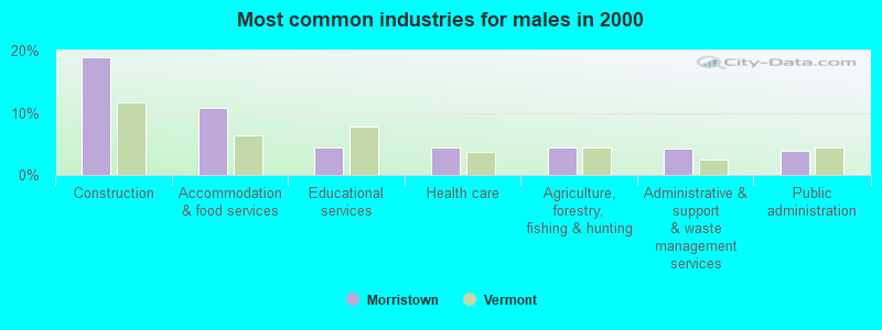
- Construction (19.0%)
- Accommodation & food services (10.9%)
- Educational services (4.5%)
- Health care (4.4%)
- Agriculture, forestry, fishing & hunting (4.3%)
- Administrative & support & waste management services (4.3%)
- Public administration (3.9%)
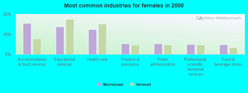
- Accommodation & food services (15.5%)
- Educational services (13.8%)
- Health care (12.4%)
- Finance & insurance (5.3%)
- Public administration (5.3%)
- Professional, scientific, technical services (4.9%)
- Food & beverage stores (4.8%)
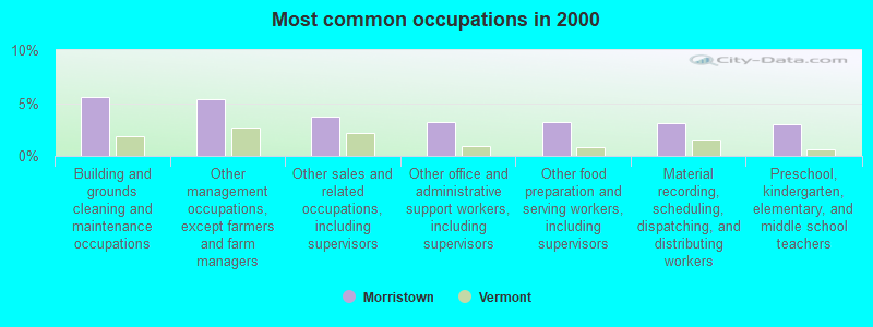
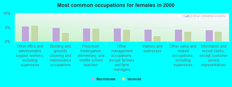
- Building and grounds cleaning and maintenance occupations (5.5%)
- Other management occupations, except farmers and farm managers (5.3%)
- Other sales and related occupations, including supervisors (3.7%)
- Other office and administrative support workers, including supervisors (3.2%)
- Other food preparation and serving workers, including supervisors (3.2%)
- Material recording, scheduling, dispatching, and distributing workers (3.1%)
- Preschool, kindergarten, elementary, and middle school teachers (3.0%)
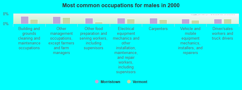
- Building and grounds cleaning and maintenance occupations (6.1%)
- Other management occupations, except farmers and farm managers (5.8%)
- Other food preparation and serving workers, including supervisors (4.6%)
- Electrical equipment mechanics and other installation, maintenance, and repair workers, including supervisors (4.6%)
- Carpenters (4.5%)
- Vehicle and mobile equipment mechanics, installers, and repairers (4.0%)
- Driver/sales workers and truck drivers (3.8%)
- Other office and administrative support workers, including supervisors (5.5%)
- Building and grounds cleaning and maintenance occupations (4.9%)
- Preschool, kindergarten, elementary, and middle school teachers (4.8%)
- Other management occupations, except farmers and farm managers (4.8%)
- Waiters and waitresses (4.4%)
- Other sales and related occupations, including supervisors (4.3%)
- Information and record clerks, except customer service representatives (4.1%)
Average climate in Morristown, Vermont
Based on data reported by over 4,000 weather stations


(lower is better)
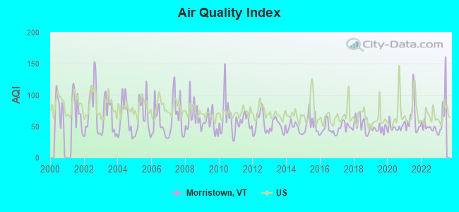
Air Quality Index (AQI) level in 2022 was 47.8. This is significantly better than average.
| City: | 47.8 |
| U.S.: | 72.6 |
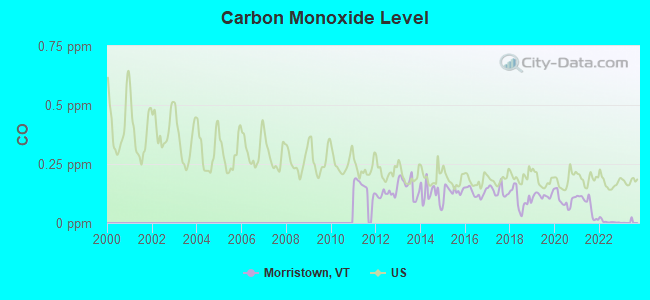
Carbon Monoxide (CO) [ppm] level in 2022 was 0.00585. This is significantly better than average. Closest monitor was 13.0 miles away from the city center.
| City: | 0.00585 |
| U.S.: | 0.25132 |
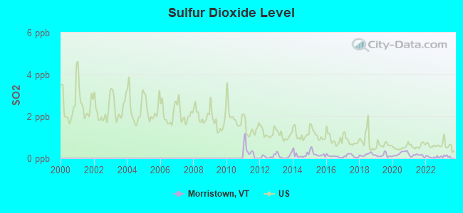
Sulfur Dioxide (SO2) [ppb] level in 2022 was 0.0619. This is significantly better than average. Closest monitor was 13.0 miles away from the city center.
| City: | 0.0619 |
| U.S.: | 1.5147 |
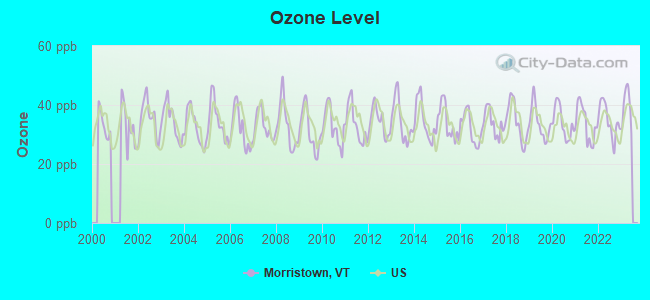
Ozone [ppb] level in 2022 was 34.8. This is about average. Closest monitor was 13.0 miles away from the city center.
| City: | 34.8 |
| U.S.: | 33.3 |
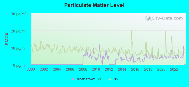
Particulate Matter (PM2.5) [µg/m3] level in 2022 was 4.62. This is significantly better than average. Closest monitor was 13.0 miles away from the city center.
| City: | 4.62 |
| U.S.: | 8.11 |
Earthquake activity:
Morristown-area historical earthquake activity is significantly above Vermont state average. It is 72% smaller than the overall U.S. average.On 4/20/2002 at 10:50:47, a magnitude 5.3 (5.3 ML, Depth: 3.0 mi, Class: Moderate, Intensity: VI - VII) earthquake occurred 53.8 miles away from the city center
On 4/20/2002 at 10:50:47, a magnitude 5.2 (5.2 MB, 4.2 MS, 5.2 MW, 5.0 MW) earthquake occurred 55.0 miles away from the city center
On 10/7/1983 at 10:18:46, a magnitude 5.3 (5.1 MB, 5.3 LG, 5.1 ML) earthquake occurred 95.5 miles away from Morristown center
On 1/19/1982 at 00:14:42, a magnitude 4.7 (4.5 MB, 4.7 MD, 4.5 LG, Class: Light, Intensity: IV - V) earthquake occurred 88.4 miles away from Morristown center
On 10/16/2012 at 23:12:25, a magnitude 4.7 (4.7 ML, Depth: 10.0 mi) earthquake occurred 117.3 miles away from Morristown center
On 6/16/1995 at 12:13:11, a magnitude 3.8 (3.8 LG, Depth: 3.1 mi, Class: Light, Intensity: II - III) earthquake occurred 38.9 miles away from the city center
Magnitude types: regional Lg-wave magnitude (LG), body-wave magnitude (MB), duration magnitude (MD), local magnitude (ML), surface-wave magnitude (MS), moment magnitude (MW)
Natural disasters:
The number of natural disasters in Lamoille County (28) is a lot greater than the US average (15).Major Disasters (Presidential) Declared: 22
Emergencies Declared: 2
Causes of natural disasters: Floods: 20, Storms: 19, Tornadoes: 2, Tropical Storms: 2, Winds: 2, Winter Storms: 2, Heavy Rain: 1, Hurricane: 1, Landslide: 1, Snowstorm: 1, Other: 1 (Note: some incidents may be assigned to more than one category).
Hospitals and medical centers near Morristown:
- ELMORE HOUSE AT COPLEY MANOR (Nursing Home, about 1 miles away; MORRISVILLE, VT)
- COPLEY HOSPITAL Critical Access Hospitals (about 1 miles away; MORRISVILLE, VT)
- THE MANOR, INC (Nursing Home, about 1 miles away; MORRISVILLE, VT)
- LAMOILLE HOME HEALTH AND HOSPICE (Home Health Center, about 1 miles away; MORRISVILLE, VT)
Airports located in Morristown:
- Mountain View Farm Airport (VT64) (Runways: 1)
Colleges/universities with over 2000 students nearest to Morristown:
- Saint Michael's College (about 28 miles; Colchester, VT; Full-time enrollment: 2,336)
- Community College of Vermont (about 29 miles; Winooski, VT; FT enrollment: 3,394)
- Norwich University (about 29 miles; Northfield, VT; FT enrollment: 4,221)
- University of Vermont (about 30 miles; Burlington, VT; FT enrollment: 11,566)
- Champlain College (about 30 miles; Burlington, VT; FT enrollment: 2,623)
- SUNY College at Plattsburgh (about 44 miles; Plattsburgh, NY; FT enrollment: 5,934)
- Middlebury College (about 48 miles; Middlebury, VT; FT enrollment: 3,077)
Points of interest:
Notable locations in Morristown: White Face Lodge (A), Mountain View Cottages and Campgrounds (B), Morristown Bog Natural Area (C), Lamoille Valley Railroad Depot (D), Copley Country Club (E), Farm Resort Golf Course (F), Moulds Lodge (G), Catholic Youth Camp (H), Morristown Centennial Library (I), Lamoille Valley Chamber of Commerce (J), Lamoille Grange (K), Lamoille Family Center (L), Copley Hospital Medical Library (M), Morristown Fire Department (N), Morristown Rescue Squad (O). Display/hide their locations on the map
Shopping Centers: Northgate Plaza Shopping Center (1), Morrisville Plaza Shopping Center (2). Display/hide their locations on the map
Churches in Morristown include: Advent Christian Church (A), Agape Baptist Fellowship Church (B), Cornerstone Foursquare Church (C), First Congregational Church (D), Holy Cross Catholic Church (E), Morrisville Baptist Church (F), Puffer United Methodist Church (G). Display/hide their locations on the map
Cemeteries: La Porte Cemetery (1), Mountain View Cemetery (2), Lakeview Cemetery (3), Plains-Green Lawn Cemetery (4), Pleasant View Cemetery (5), Randolph-Herrick Cemetery (6), Riverbank Cemetery (7). Display/hide their locations on the map
Lakes and reservoirs: Beaver Meadow (A), Joes Pond (B), Molly Pond (C), Lake Lamoille (D). Display/hide their locations on the map
Streams, rivers, and creeks: Ryder Brook (A), Rodman Brook (B), Mud Brook (C), Lawrence Brook (D), Kenfield Brook (E), Bedell Brook (F), Beaver Meadow Brook (G), Bahannan Brook (H), Centerville Brook (I). Display/hide their locations on the map
Parks in Morristown include: Fairground Plaza (1), Morrisville Historic District (2). Display/hide their locations on the map
Birthplace of: L. M. Shaw - Politician.
Drinking water stations with addresses in Morristown and their reported violations in the past:
CADYS FALLS WATER COOP (Address: 1844 CADY FALLS ROAD , Population served: 56, Groundwater):Past health violations:Past monitoring violations:
- MCL, Monthly (TCR) - In JUL-2011, Contaminant: Coliform. Follow-up actions: St Tech Assistance Visit (JUL-22-2011), St Formal NOV issued (JUL-22-2011), St Boil Water Order (JUL-22-2011), St Public Notif requested (JUL-22-2011), St Compliance achieved (OCT-18-2011), St Public Notif received (MAY-08-2012)
- MCL, Monthly (TCR) - In JUL-2009, Contaminant: Coliform. Follow-up actions: St Boil Water Order (AUG-05-2009), St Formal NOV issued (AUG-05-2009), St Tech Assistance Visit (AUG-05-2009), St Public Notif requested (AUG-05-2009), St Compliance achieved (NOV-08-2010)
- MCL, Monthly (TCR) - In JUN-2008, Contaminant: Coliform. Follow-up actions: St Boil Water Order (JUN-12-2008), St Formal NOV issued (JUN-12-2008), St Tech Assistance Visit (JUN-12-2008), St Public Notif requested (JUN-12-2008), St Compliance achieved (NOV-08-2010)
- MCL, Monthly (TCR) - In NOV-2006, Contaminant: Coliform. Follow-up actions: St Tech Assistance Visit (NOV-30-2006), St Formal NOV issued (NOV-30-2006), St Public Notif requested (NOV-30-2006), St Boil Water Order (NOV-30-2006), St Compliance achieved (DEC-11-2006)
- MCL, Monthly (TCR) - In AUG-2005, Contaminant: Coliform. Follow-up actions: St Violation/Reminder Notice (SEP-15-2005), St Boil Water Order (SEP-15-2005), St Tech Assistance Visit (SEP-15-2005), St Public Notif requested (SEP-15-2005), St Public Notif received (OCT-12-2005), St Compliance achieved (NOV-08-2010)
- Monitoring and Reporting (DBP) - Between JUL-2011 and SEP-2011, Contaminant: Chlorine. Follow-up actions: St Public Notif requested (JAN-27-2012), St Formal NOV issued (JAN-27-2012), St Public Notif received (MAY-09-2012), St Compliance achieved (FEB-11-2013)
- Lead Consumer Notice - In APR-01-2011, Contaminant: Lead and Copper Rule. Follow-up actions: St Formal NOV issued (APR-26-2011)
- Monitoring and Reporting (DBP) - Between APR-2011 and JUN-2011, Contaminant: Chlorine. Follow-up actions: St Public Notif requested (JUL-01-2011), St Formal NOV issued (JUL-01-2011), St Public Notif received (MAY-08-2012), St Compliance achieved (FEB-11-2013)
- Monitoring and Reporting (DBP) - Between JUL-2010 and SEP-2010, Contaminant: TTHM. Follow-up actions: St Formal NOV issued (DEC-14-2010), St Tech Assistance Visit (DEC-14-2010), St Public Notif requested (DEC-14-2010), St Public Notif received (APR-26-2011)
- Monitoring and Reporting (DBP) - Between JUL-2010 and SEP-2010, Contaminant: Total Haloacetic Acids (HAA5). Follow-up actions: St Formal NOV issued (DEC-14-2010), St Tech Assistance Visit (DEC-14-2010), St Public Notif requested (DEC-14-2010), St Public Notif received (APR-26-2011)
- 2 routine major monitoring violations
- 2 minor monitoring violations
- One regular monitoring violation
- 3 other older monitoring violations
| This town: | 2.3 people |
| Vermont: | 2.3 people |
| This town: | 62.1% |
| Whole state: | 62.5% |
| This town: | 8.7% |
| Whole state: | 9.2% |
Likely homosexual households (counted as self-reported same-sex unmarried-partner households)
- Lesbian couples: 0.5% of all households
- Gay men: 0.1% of all households
| This town: | 10.3% |
| Whole state: | 9.4% |
| This town: | 3.7% |
| Whole state: | 3.6% |
People in group quarters in Morristown in 2010:
- 72 people in nursing facilities/skilled-nursing facilities
- 22 people in residential treatment centers for adults
- 7 people in workers' group living quarters and job corps centers
- 2 people in group homes intended for adults
2 people in other nonhousehold living situations in 2000
For population 15 years and over in Morristown:
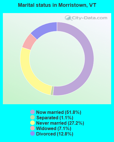
- Never married: 27.2%
- Now married: 51.8%
- Separated: 1.1%
- Widowed: 7.1%
- Divorced: 12.8%
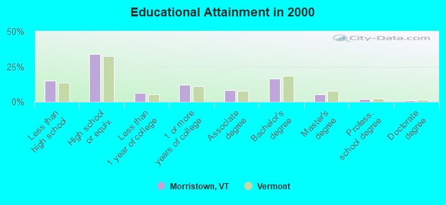
For population 25 years and over in Morristown:
- High school or higher: 84.9%
- Bachelor's degree or higher: 24.0%
- Graduate or professional degree: 7.8%
- Unemployed: 3.5%
- Mean travel time to work (commute): 22.1 minutes
| Here: | 11.2 |
| Vermont average: | 11.7 |
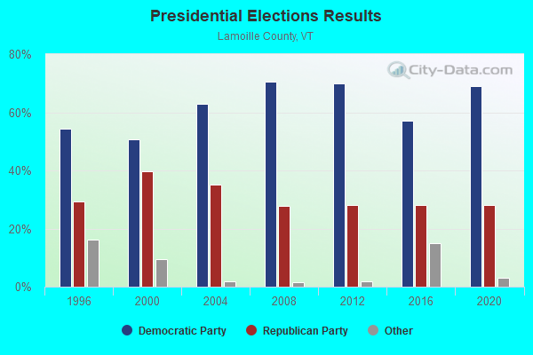
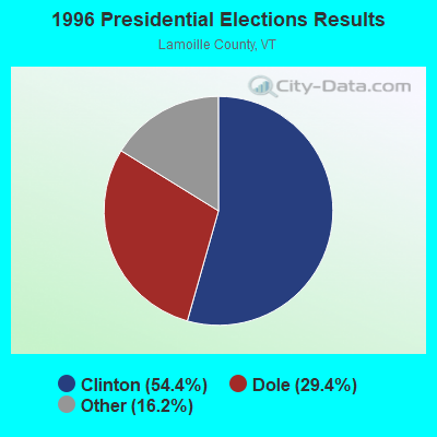
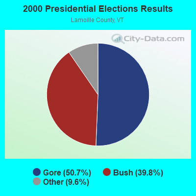
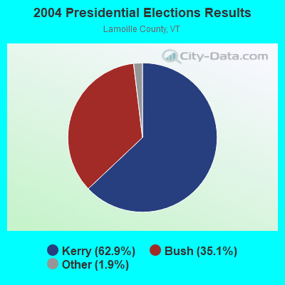

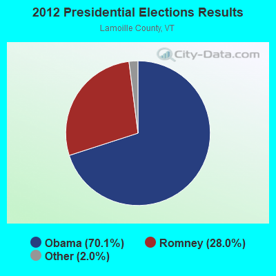
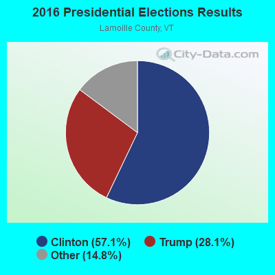
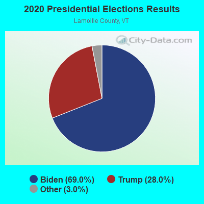
Graphs represent county-level data. Detailed 2008 Election Results
Religion statistics for Morristown, VT (based on Lamoille County data)
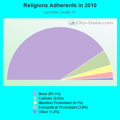
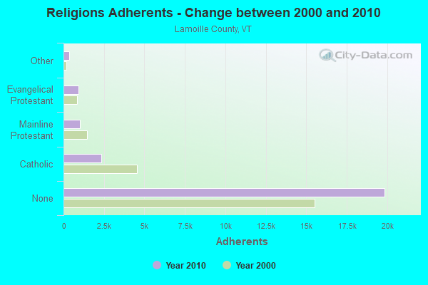
| Religion | Adherents | Congregations |
|---|---|---|
| Catholic | 2,339 | 7 |
| Mainline Protestant | 1,006 | 11 |
| Evangelical Protestant | 939 | 9 |
| Other | 344 | 4 |
| None | 19,847 | - |
Food Environment Statistics:
| This county: | 4.46 / 10,000 pop. |
| Vermont: | 3.84 / 10,000 pop. |
| Lamoille County: | 3.24 / 10,000 pop. |
| Vermont: | 1.95 / 10,000 pop. |
| Lamoille County: | 6.08 / 10,000 pop. |
| Vermont: | 6.40 / 10,000 pop. |
| This county: | 16.22 / 10,000 pop. |
| Vermont: | 11.52 / 10,000 pop. |
| Here: | 6.5% |
| Vermont: | 6.8% |
| Lamoille County: | 23.1% |
| Vermont: | 22.3% |
| This county: | 13.8% |
| Vermont: | 13.3% |
Strongest AM radio stations in Morristown:
- WDEV (550 AM; 5 kW; WATERBURY, VT; Owner: RADIO VERMONT, INC.)
- WCHP (760 AM; 35 kW; CHAMPLAIN, NY; Owner: CHAMPLAIN RADIO, INC.)
- WVMT (620 AM; 5 kW; BURLINGTON, VT; Owner: SISON BROADCASTING, INC.)
- WICY (1490 AM; 50 kW; MALONE, NY; Owner: CARTIER COMMUNICATIONS INC.)
- WVAA (1390 AM; 5 kW; BURLINGTON, VT; Owner: RADIO VERMONT, KDR, LLC)
- WTWN (1100 AM; daytime; 5 kW; WELLS RIVER, VT; Owner: PUFFER BROADCASTING, INC.)
- WGY (810 AM; 50 kW; SCHENECTADY, NY; Owner: CLEAR CHANNEL BROADCASTING LICENSES, INC.)
- WEAV (960 AM; 5 kW; PLATTSBURGH, NY; Owner: CLEAR CHANNEL BROADCASTING LICENSES, INC.)
- WRKO (680 AM; 50 kW; BOSTON, MA; Owner: ENTERCOM BOSTON LICENSE, LLC)
- WNNZ (640 AM; 50 kW; WESTFIELD, MA; Owner: CLEAR CHANNEL BROADCASTING LICENSES, INC.)
- WTWK (1070 AM; daytime; 5 kW; PLATTSBURGH, NY; Owner: CHAMPLAIN COMMUNICATIONS CORPORATION)
- WCRN (830 AM; 50 kW; WORCESTER, MA; Owner: CARTER BROADCASTING CORPORATION)
- WEEI (850 AM; 50 kW; BOSTON, MA; Owner: ENTERCOM BOSTON LICENSE, LLC)
Strongest FM radio stations in Morristown:
- WLKC (103.3 FM; WATERBURY, VT; Owner: RADIO BROADCASTING SERVICES, INC.)
- WVPS (107.9 FM; BURLINGTON, VT; Owner: VERMONT PUBLIC RADIO)
- WEZF (92.9 FM; BURLINGTON, VT; Owner: CAPSTAR TX LIMITED PARTNERSHIP)
- WCVT (101.7 FM; STOWE, VT; Owner: RADIO VERMONT CLASSICS, L.L.C.)
- WNCS (104.7 FM; MONTPELIER, VT; Owner: MONTPELIER BROADCASTING, INC.)
- WLVB (93.9 FM; MORRISVILLE, VT; Owner: RADIO VERMONT, INC.)
- WDEV-FM (96.1 FM; WARREN, VT; Owner: RADIO VERMONT, INC.)
- WDOT (95.7 FM; DANVILLE, VT; Owner: MONTPELIER BROADCASTING INC)
- WGLY-FM (91.5 FM; BOLTON, VT; Owner: CHRISTIAN MINISTRIES, INC.)
- WGMT (97.7 FM; LYNDON, VT; Owner: VERMONT BROADCAST ASSOCIATES, INC.)
- WPKQ (103.7 FM; NORTH CONWAY, NH; Owner: CITADEL BROADCASTING COMPANY)
- WHOM (94.9 FM; MT. WASHINGTON, NH; Owner: CITADEL BROADCASTING COMPANY)
- WCEL (91.9 FM; PLATTSBURGH, NY; Owner: WAMC)
- WLFE-FM (102.3 FM; ST. ALBANS, VT; Owner: CHAMPLAIN COMMUNICATIONS CORP.)
- WEBK (105.3 FM; KILLINGTON, VT; Owner: 6 JOHNSON ROAD LICENSES, INC.)
- WCPV (101.3 FM; ESSEX, NY; Owner: CAPSTAR TX LIMITED PARTNERSHIP)
- WJJR (98.1 FM; RUTLAND, VT; Owner: 6 JOHNSON ROAD LICENSES, INC.)
- WZRT (97.1 FM; RUTLAND, VT; Owner: CAPSTAR TX LIMITED PARTNERSHIP)
- WGLV (91.7 FM; WOODSTOCK, VT; Owner: CHRISTIAN MINISTRIES INC)
- WHDQ-FM1 (106.1 FM; RUTLAND, VT; Owner: GREAT NORTHERN RADIO, L.L.C.)
TV broadcast stations around Morristown:
- WVNY (Channel 22; BURLINGTON, VT; Owner: C-22 FCC LICENSEE SUBSIDIARY, LLC)
- WCAX-TV (Channel 3; BURLINGTON, VT; Owner: MT. MANSFIELD TELEVISION, INC.)
- W54CV (Channel 54; BARRE, VT; Owner: NYN, LLC)
- WETK (Channel 33; BURLINGTON, VT; Owner: VERMONT ETV, INC.)
- National Bridge Inventory (NBI) Statistics
- 20Number of bridges
- 200ft / 61.1mTotal length
- $4,901,000Total costs
- 45,980Total average daily traffic
- 3,409Total average daily truck traffic
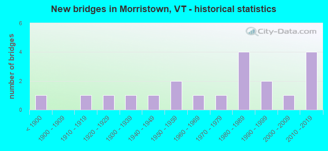
- New bridges - historical statistics
- 1Before 1900
- 11910-1919
- 11920-1929
- 11930-1939
- 11940-1949
- 21950-1959
- 11960-1969
- 11970-1979
- 41980-1989
- 21990-1999
- 12000-2009
- 42010-2019
FCC Registered Antenna Towers:
21 (See the full list of FCC Registered Antenna Towers in Morristown)FCC Registered Broadcast Land Mobile Towers:
1- Fire Station Main St (Lat: 44.563667 Lon: -72.599278), Call Sign: KNEA295,
Assigned Frequencies: 154.445 MHz, Grant Date: 07/25/2022, Expiration Date: 10/13/2032, Registrant: Town Of Morristown, 43 Portland Street, Morrisville, VT 05661, Phone: (802) 888-5147, Fax: (802) 888-6378, Email:
FCC Registered Microwave Towers:
1- Ct Rt 15 & Needle's Eye Rd (Lat: 44.578639 Lon: -72.597056), Overall height: 7 m, Call Sign: WMU448,
Assigned Frequencies: 947.500 MHz, Grant Date: 12/10/1993, Expiration Date: 04/01/2030, Registrant: Radio Vermont, Inc., P.O. Box 55, Waterbury, VT 05676
FCC Registered Maritime Coast & Aviation Ground Towers:
1- Morrisville Stowe State Airport (Lat: 44.534778 Lon: -72.613444), Type: Building, Overall height: 5 m, Call Sign: WYI2,
Assigned Frequencies: 122.800 MHz, Grant Date: 03/27/2019, Expiration Date: 03/18/2029, Registrant: Vermont Agency Of Transportation, One National Life Drive, Montpelier, VT 05633-5001, Phone: (802) 498-5763, Fax: (802) 828-3983, Email:
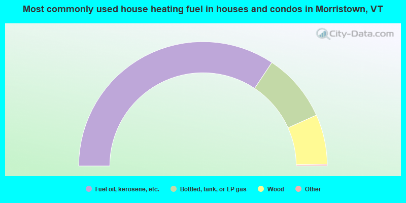
- 68.7%Fuel oil, kerosene, etc.
- 17.9%Bottled, tank, or LP gas
- 13.0%Wood
- 0.3%Other fuel
- 0.1%Electricity
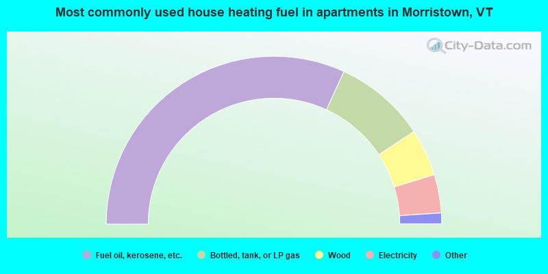
- 63.7%Fuel oil, kerosene, etc.
- 17.7%Bottled, tank, or LP gas
- 9.1%Wood
- 7.4%Electricity
- 1.6%Other fuel
- 0.3%Utility gas
- 0.3%Coal or coke
Morristown compared to Vermont state average:
- Unemployed percentage significantly below state average.
- Foreign-born population percentage below state average.
- Length of stay since moving in significantly above state average.
- Number of rooms per house significantly below state average.
- House age significantly below state average.
Morristown on our top lists:
- #4 on the list of "Top 101 cities with largest percentage of females in occupations: air transportation workers (population 5,000+)"
- #7 on the list of "Top 101 cities with largest percentage of males in occupations: other food preparation and serving workers including supervisors (population 5,000+)"
- #16 on the list of "Top 101 cities with largest percentage of females in industries: u. s. postal service (population 5,000+)"
- #19 on the list of "Top 101 cities with largest percentage of females in occupations: secondary school teachers (population 5,000+)"
- #33 on the list of "Top 101 cities with largest percentage of females in occupations: other health diagnosing and treating practitioners and technical occupations (population 5,000+)"
- #39 on the list of "Top 101 cities with largest percentage of males in industries: miscellaneous durable goods merchant wholesalers (population 5,000+)"
- #40 on the list of "Top 101 cities with largest percentage of females in occupations: pipelayers, plumbers, pipefitters, and steamfitters (population 5,000+)"
- #50 on the list of "Top 101 cities with largest percentage of males in industries: furniture and related product manufacturing (population 5,000+)"
- #52 on the list of "Top 101 cities with largest percentage of males in occupations: motor vehicle operators except bus and truck drivers (population 5,000+)"
- #55 on the list of "Top 101 cities with largest percentage of females in industries: repair and maintenance (population 5,000+)"
- #68 on the list of "Top 101 cities with largest percentage of females in industries: other transportation, and support activities, and couriers (population 5,000+)"
- #70 on the list of "Top 101 cities with largest percentage of females in industries: other direct selling establishments (population 5,000+)"
- #81 on the list of "Top 101 cities with largest percentage of males in industries: apparel (population 5,000+)"
- #81 on the list of "Top 101 cities with largest percentage of males in industries: farm product raw materials merchant wholesalers (population 5,000+)"
- #90 on the list of "Top 101 cities with largest percentage of males in industries: petroleum and petroleum products merchant wholesalers (population 5,000+)"
- #92 on the list of "Top 101 cities with largest percentage of males in industries: miscellaneous manufacturing (population 5,000+)"
- #93 on the list of "Top 101 cities with largest percentage of males in industries: building material and garden equipment and supplies dealers (population 5,000+)"
- #82 (05661) on the list of "Top 101 zip codes with the largest percentage of Scottish first ancestries (pop 5,000+)"
- #95 on the list of "Top 101 counties with the lowest surface withdrawal of fresh water for public supply"
- #96 on the list of "Top 101 counties with highest percentage of residents voting for Obama (Democrat) in the 2012 Presidential Election"

|
Total of 3 patent applications in 2008-2024.