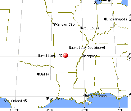
Morrilton, Arkansas

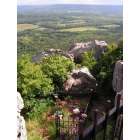
Morrilton: Petit Jean State Park

Morrilton
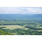
Morrilton: Lookout from Petit Jean Mountain, Morrilton, AR

Morrilton: Lake at Petit Jean Mountain, Morrilton, AR
Morrilton: Grave at Petit Jean Mountain, Morrilton, AR
- add
your
Submit your own pictures of this city and show them to the world
- OSM Map
- General Map
- Google Map
- MSN Map

Population change since 2000: +8.1%
 |
| Males: 3,118 | |
| Females: 3,961 |
| Median resident age: | 37.9 years |
| Arkansas median age: | 38.9 years |
Zip codes: 72110.
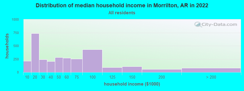
| Morrilton: | $42,909 |
| AR: | $55,432 |
Estimated per capita income in 2022: $25,339 (it was $16,957 in 2000)
Morrilton city income, earnings, and wages data
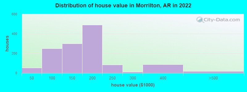
Estimated median house or condo value in 2022: $163,414 (it was $58,800 in 2000)
| Morrilton: | $163,414 |
| AR: | $179,800 |
Mean prices in 2022: all housing units: $176,113; detached houses: $175,648; mobile homes: $29,810
Median gross rent in 2022: $640.
(22.3% for White Non-Hispanic residents, 31.5% for Black residents, 13.3% for Hispanic or Latino residents, 70.3% for two or more races residents)
Detailed information about poverty and poor residents in Morrilton, AR


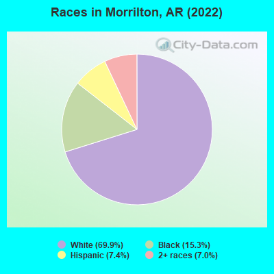
- 4,91969.9%White alone
- 1,07615.3%Black alone
- 5227.4%Hispanic
- 4907.0%Two or more races
According to our research of Arkansas and other state lists, there were 26 registered sex offenders living in Morrilton, Arkansas as of May 02, 2024.
The ratio of all residents to sex offenders in Morrilton is 261 to 1.
Type |
2009 |
2010 |
2011 |
2012 |
2013 |
2014 |
2015 |
2016 |
2017 |
2018 |
2019 |
2020 |
2021 |
2022 |
|---|---|---|---|---|---|---|---|---|---|---|---|---|---|---|
| Murders (per 100,000) | 0 (0.0) | 0 (0.0) | 1 (14.7) | 0 (0.0) | 1 (14.7) | 0 (0.0) | 0 (0.0) | 0 (0.0) | 1 (14.9) | 0 (0.0) | 0 (0.0) | 0 (0.0) | 0 (0.0) | 1 (14.1) |
| Rapes (per 100,000) | 3 (45.6) | 4 (59.1) | 2 (29.3) | 3 (44.2) | 2 (29.5) | 3 (44.1) | 8 (118.6) | 7 (104.0) | 4 (59.6) | 6 (90.5) | 11 (165.9) | 19 (286.5) | 8 (119.9) | 5 (70.4) |
| Robberies (per 100,000) | 9 (136.7) | 2 (29.6) | 2 (29.3) | 0 (0.0) | 0 (0.0) | 2 (29.4) | 2 (29.7) | 1 (14.9) | 1 (14.9) | 1 (15.1) | 2 (30.2) | 4 (60.3) | 1 (15.0) | 1 (14.1) |
| Assaults (per 100,000) | 21 (319.0) | 18 (266.0) | 14 (205.3) | 17 (250.3) | 15 (220.9) | 10 (146.9) | 12 (177.9) | 10 (148.5) | 6 (89.4) | 5 (75.4) | 13 (196.0) | 14 (211.1) | 22 (329.7) | 20 (281.5) |
| Burglaries (per 100,000) | 76 (1,154) | 62 (916.2) | 50 (733.4) | 36 (530.0) | 40 (589.2) | 43 (631.6) | 43 (637.6) | 33 (490.1) | 49 (729.7) | 18 (271.4) | 9 (135.7) | 16 (241.3) | 22 (329.7) | 19 (267.5) |
| Thefts (per 100,000) | 368 (5,589) | 369 (5,453) | 417 (6,116) | 264 (3,887) | 312 (4,596) | 284 (4,172) | 357 (5,294) | 351 (5,213) | 334 (4,974) | 260 (3,920) | 227 (3,423) | 199 (3,001) | 277 (4,152) | 255 (3,590) |
| Auto thefts (per 100,000) | 18 (273.4) | 13 (192.1) | 11 (161.3) | 6 (88.3) | 6 (88.4) | 9 (132.2) | 14 (207.6) | 13 (193.1) | 12 (178.7) | 10 (150.8) | 6 (90.5) | 9 (135.7) | 13 (194.8) | 9 (126.7) |
| Arson (per 100,000) | 3 (45.6) | 1 (14.8) | 2 (29.3) | 0 (0.0) | 3 (44.2) | 1 (14.7) | 3 (44.5) | 0 (0.0) | 3 (44.7) | 3 (45.2) | 1 (15.1) | 1 (15.1) | 3 (45.0) | 4 (56.3) |
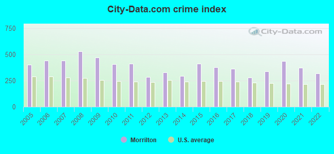
| City-Data.com crime index | 467.5 | 407.0 | 411.6 | 285.0 | 329.4 | 295.1 | 412.4 | 375.6 | 364.1 | 279.8 | 334.6 | 437.3 | 371.1 | 317.4 |
The City-Data.com crime index weighs serious crimes and violent crimes more heavily. Higher means more crime, U.S. average is 246.1. It adjusts for the number of visitors and daily workers commuting into cities.
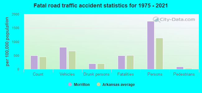
Crime rate in Morrilton detailed stats: murders, rapes, robberies, assaults, burglaries, thefts, arson
Full-time law enforcement employees in 2021, including police officers: 28 (25 officers - 24 male; 1 female).
| Officers per 1,000 residents here: | 3.75 |
| Arkansas average: | 2.25 |
 Recent articles from our blog. Our writers, many of them Ph.D. graduates or candidates, create easy-to-read articles on a wide variety of topics.

 | How does Arkansas compare to East Tennessee? (15 replies) |
| Family reunion accommodations in NW Arkansas (26 replies) |
| I am looking for a nice town to settle in (11 replies) |
| 1st trip into Arkansas in search of retirement haven (139 replies) |
| Planning my vacation to Arkansas..suggestions please! (90 replies) |
| Buffalo River info (9 replies) |
Latest news from Morrilton, AR collected exclusively by city-data.com from local newspapers, TV, and radio stations
Ancestries: American (25.0%), English (10.2%), European (5.5%), German (5.3%), Irish (5.3%), African (2.3%).
Current Local Time: CST time zone
Incorporated on 11/24/1879
Elevation: 383 feet
Land area: 8.22 square miles.
Population density: 861 people per square mile (low).
280 residents are foreign born (3.9% Latin America).
| This city: | 4.0% |
| Arkansas: | 5.0% |
Median real estate property taxes paid for housing units with mortgages in 2022: $787 (0.5%)
Median real estate property taxes paid for housing units with no mortgage in 2022: $945 (0.5%)
Nearest city with pop. 50,000+: Little Rock, AR  (37.3 miles , pop. 183,133).
Nearest city with pop. 200,000+: Memphis, TN (156.7 miles , pop. 650,100).
Nearest city with pop. 1,000,000+: Dallas, TX (283.5 miles , pop. 1,188,580).
Nearest cities:
), ), ), ), Latitude: 35.16 N, Longitude: 92.74 W
Daytime population change due to commuting: +1,743 (+24.8%)
Workers who live and work in this city: 1,480 (53.3%)
Area code: 501
Morrilton, Arkansas accommodation & food services, waste management - Economy and Business Data
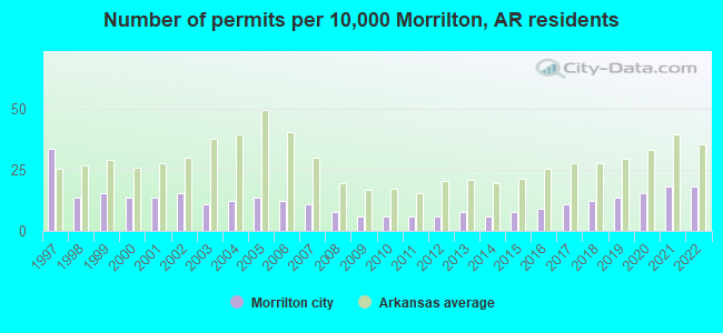
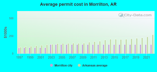
Single-family new house construction building permits:
- 2022: 12 buildings, average cost: $127,800
- 2021: 12 buildings, average cost: $127,800
- 2020: 10 buildings, average cost: $127,800
- 2019: 9 buildings, average cost: $127,800
- 2018: 8 buildings, average cost: $127,800
- 2017: 7 buildings, average cost: $127,800
- 2016: 6 buildings, average cost: $127,800
- 2015: 5 buildings, average cost: $127,800
- 2014: 4 buildings, average cost: $127,800
- 2013: 5 buildings, average cost: $127,800
- 2012: 4 buildings, average cost: $127,800
- 2011: 4 buildings, average cost: $127,800
- 2010: 4 buildings, average cost: $127,800
- 2009: 4 buildings, average cost: $127,800
- 2008: 5 buildings, average cost: $127,800
- 2007: 7 buildings, average cost: $127,800
- 2006: 8 buildings, average cost: $127,800
- 2005: 9 buildings, average cost: $127,800
- 2004: 8 buildings, average cost: $127,800
- 2003: 7 buildings, average cost: $127,800
- 2002: 10 buildings, average cost: $86,000
- 2001: 9 buildings, average cost: $86,000
- 2000: 9 buildings, average cost: $86,000
- 1999: 10 buildings, average cost: $86,000
- 1998: 9 buildings, average cost: $86,000
- 1997: 22 buildings, average cost: $81,900
| Here: | 3.9% |
| Arkansas: | 3.4% |
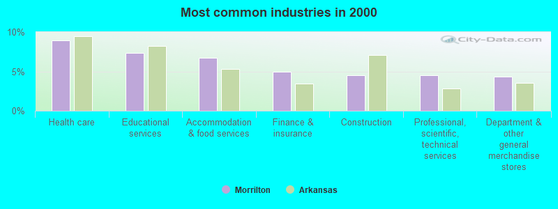
- Health care (8.9%)
- Educational services (7.3%)
- Accommodation & food services (6.8%)
- Finance & insurance (5.0%)
- Construction (4.5%)
- Professional, scientific, technical services (4.5%)
- Department & other general merchandise stores (4.3%)
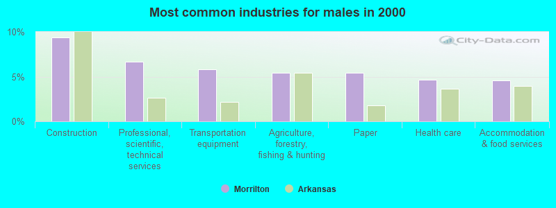
- Construction (9.4%)
- Professional, scientific, technical services (6.6%)
- Transportation equipment (5.8%)
- Agriculture, forestry, fishing & hunting (5.4%)
- Paper (5.4%)
- Health care (4.7%)
- Accommodation & food services (4.6%)
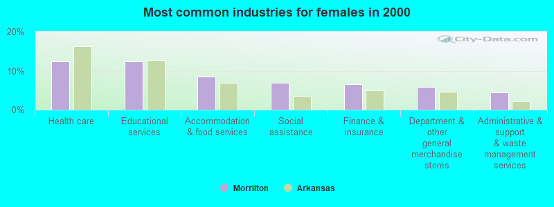
- Health care (12.4%)
- Educational services (12.4%)
- Accommodation & food services (8.5%)
- Social assistance (6.9%)
- Finance & insurance (6.6%)
- Department & other general merchandise stores (5.8%)
- Administrative & support & waste management services (4.4%)
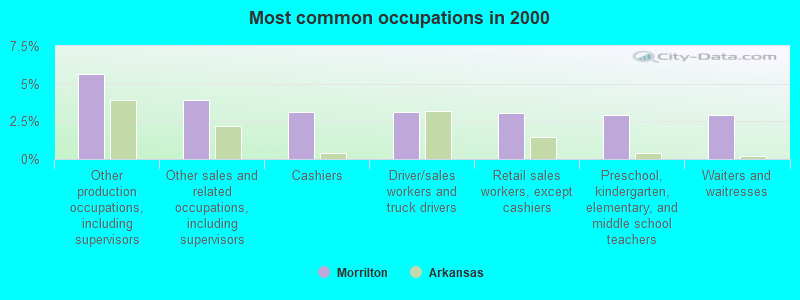
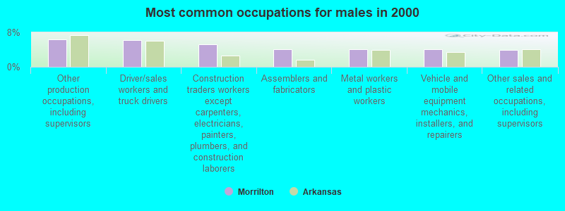
- Other production occupations, including supervisors (5.7%)
- Other sales and related occupations, including supervisors (3.9%)
- Cashiers (3.1%)
- Driver/sales workers and truck drivers (3.1%)
- Retail sales workers, except cashiers (3.1%)
- Preschool, kindergarten, elementary, and middle school teachers (2.9%)
- Waiters and waitresses (2.9%)
- Other production occupations, including supervisors (6.4%)
- Driver/sales workers and truck drivers (6.3%)
- Construction traders workers except carpenters, electricians, painters, plumbers, and construction laborers (5.2%)
- Assemblers and fabricators (4.2%)
- Metal workers and plastic workers (4.1%)
- Vehicle and mobile equipment mechanics, installers, and repairers (4.1%)
- Other sales and related occupations, including supervisors (3.9%)
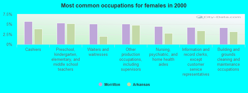
- Cashiers (5.7%)
- Preschool, kindergarten, elementary, and middle school teachers (5.4%)
- Waiters and waitresses (5.1%)
- Other production occupations, including supervisors (5.1%)
- Nursing, psychiatric, and home health aides (4.5%)
- Information and record clerks, except customer service representatives (4.3%)
- Building and grounds cleaning and maintenance occupations (4.2%)
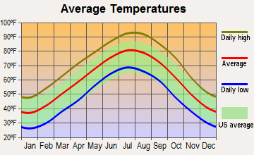
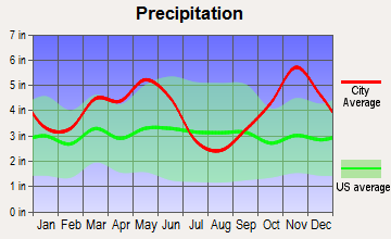
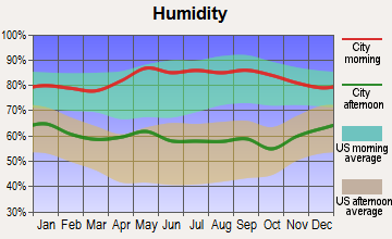
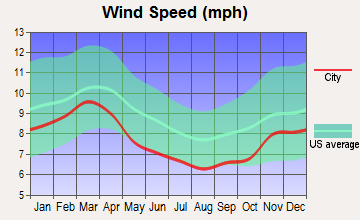
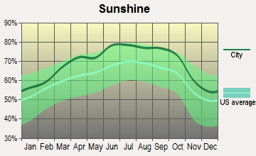
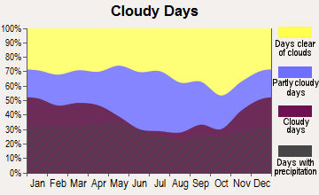
Average climate in Morrilton, Arkansas
Based on data reported by over 4,000 weather stations

|
|


Tornado activity:
Morrilton-area historical tornado activity is slightly above Arkansas state average. It is 140% greater than the overall U.S. average.
On 4/10/1965, a category F4 (max. wind speeds 207-260 mph) tornado 18.1 miles away from the Morrilton city center killed 6 people and injured 200 people and caused between $5,000,000 and $50,000,000 in damages.
On 2/5/2008, a category F4 tornado 19.0 miles away from the city center killed 13 people and injured 139 people and caused $119 million in damages.
Earthquake activity:
Morrilton-area historical earthquake activity is significantly above Arkansas state average. It is 526% greater than the overall U.S. average.On 11/6/2011 at 03:53:10, a magnitude 5.7 (5.7 MW, Depth: 3.2 mi, Class: Moderate, Intensity: VI - VII) earthquake occurred 228.4 miles away from Morrilton center
On 9/3/2016 at 12:02:44, a magnitude 5.8 (5.8 MW, Depth: 3.5 mi) earthquake occurred 250.8 miles away from the city center
On 2/28/2011 at 05:00:50, a magnitude 4.7 (4.7 MW, Depth: 2.0 mi, Class: Light, Intensity: IV - V) earthquake occurred 23.2 miles away from Morrilton center
On 1/21/1982 at 00:33:54, a magnitude 4.7 (4.5 MB, 4.7 LG, 4.5 LG) earthquake occurred 30.2 miles away from the city center
On 5/4/2001 at 06:42:12, a magnitude 4.7 (4.2 MB, 4.7 LG, 4.5 LG) earthquake occurred 31.2 miles away from Morrilton center
On 3/25/1976 at 00:41:20, a magnitude 5.0 (4.9 MB, 5.0 LG) earthquake occurred 140.2 miles away from the city center
Magnitude types: regional Lg-wave magnitude (LG), body-wave magnitude (MB), moment magnitude (MW)
Natural disasters:
The number of natural disasters in Conway County (23) is greater than the US average (15).Major Disasters (Presidential) Declared: 17
Emergencies Declared: 3
Causes of natural disasters: Storms: 17, Floods: 15, Tornadoes: 11, Winter Storms: 3, Hurricanes: 2, Drought: 1, Wind: 1, Other: 1 (Note: some incidents may be assigned to more than one category).

Hospitals and medical centers in Morrilton:
- COTTONWOOD PLACE (610 WEST CHURCH STREET)
- ST VINCENT MORRILTON (Voluntary non-profit - Private, #4 HOSPITAL DRIVE)
- CONWAY COUNTY HEALTH UNIT (100 HOSPITAL DRIVE)
- PETIT JEAN HOME HEALTH (#4 HOSPITAL DRIVE)
- BROOKRIDGE COVE REHABILITATION AND CARE CENTER (1000 BROOKRIDGE LANE)
- RIVER CHASE REHABILITATION AND CARE CENTER (# 12 HOSPITAL DRIVE)
Airports and heliports located in Morrilton:
- Morrilton Municipal Airport (BDQ) (Runways: 1, Itinerant Ops: 3,000, Local Ops: 4,000, Military Ops: 400)
- Petit Jean Park Airport (MPJ) (Runways: 1, Itinerant Ops: 2,000, Military Ops: 50)
- Brickey Pvt Airport (AR43) (Runways: 1)
- Morrilton Airport (07AR) (Runways: 1)
- St Anthony's Medical Center Heliport (AR65)
College/University in Morrilton:
Colleges/universities with over 2000 students nearest to Morrilton:
- University of Central Arkansas (about 17 miles; Conway, AR; Full-time enrollment: 9,972)
- Arkansas Tech University (about 25 miles; Russellville, AR; FT enrollment: 9,038)
- Pulaski Technical College (about 37 miles; North Little Rock, AR; FT enrollment: 8,396)
- University of Arkansas at Little Rock (about 38 miles; Little Rock, AR; FT enrollment: 9,227)
- Arkansas State University-Beebe (about 49 miles; Beebe, AR; FT enrollment: 3,387)
- National Park Community College (about 50 miles; Hot Springs, AR; FT enrollment: 2,237)
- Harding University (about 58 miles; Searcy, AR; FT enrollment: 5,360)
Public high schools in Morrilton:
- RIVER VALLEY VOCATIONAL CENTER (Location: 1905 POOR FARM RD, Grades: 9-12)
- MORRILTON SR. HIGH SCHOOL (Location: 701 E HARDING ST, Grades: 9-12)
Private high schools in Morrilton:
Public elementary/middle schools in Morrilton:
- MORRILTON JUNIOR HIGH SCHOOL (Location: 1400 POOR FARM RD, Grades: 7-8)
- MORRILTON ELEMENTARY SCHOOL (Location: 1203 N SAINT JOSEPH ST, Grades: 2-3)
- MORRILTON INTERMEDIATE SCHOOL (Location: 1907 POOR FARM RD, Grades: 4-6)
- MORRILTON PRIMARY SCHOOL (Location: 410 S BRIDGE ST, Grades: PK-1)
Points of interest:
Notable locations in Morrilton: Ruby Croom Industrial Park (A), Conway County Sheriff's Office (B), Morrilton Police Department (C), University of Arkansas Community College at Morrilton (Campus Police) (D), Conway County Courthouse (E), Conway County Library (F), Morrilton City Hall (G), Morrilton Railroad Station (H), Southern Christian Childrens Home (I), Med - Tech Emergency Medical Services of Conway County (J), Morrilton Volunteer Fire Station 1 (K). Display/hide their locations on the map
Shopping Centers: Riverland Shopping Center (1), North Hills Shopping Center (2). Display/hide their locations on the map
Churches in Morrilton include: Union Hill Church (A), Calvary Baptist Church (B), Downtown Church of Christ (C), First Assembly of God Church (D), First Baptist Church (E), First Presbyterian Church (F), First United Methodist Church (G), Garden of Gethsemane United Church of God in Christ (H), Sacred Heart Catholic Church (I). Display/hide their locations on the map
Cemeteries: Lewisburg Cemetery (1), West Cemetery (2), Elmwood Cemetery (3). Display/hide their locations on the map
Reservoir: Morrilton Sewage Lake (A). Display/hide its location on the map
Creek: Point Remove Creek (A). Display/hide its location on the map
Park in Morrilton: Point Remove Public Use Area (1). Display/hide its location on the map
Tourist attractions: Museum of Automobiles (Petit Jean Mountain), Depot Museum (101 East Railroad Avenue), Riverside Arcade (Amusement & Theme Parks; 1313 East Broadway Street).
Hotels: Tanyard Springs Resort & Conference Center (144 Tanyard Springs Road), Scottish Inn of Morrilton (356 Highway 95), Cedar Falls Motel (1627 Petit Jean Mountain), Super 8 Motel (1818 Highway 9), Days Inn (1506 North Oak Street), Petit Jean State Park - Mather Lodge (1285 Petit Jean Mnt).
Courts: Conway-County - Municipal Court Clerk (Court House), Arkansas-State - Community Correction-Department- Drug Court Color Of The (601 South Moose Street).
Birthplace of: John R. Stallings - Mathematician, Nathan Green Gordon - Navy Medal of Honor recipient, Maurice Jeffers - Basketball player.
Drinking water stations with addresses in Morrilton and their reported violations in the past:
CASA WATER DEPT (Population served: 1,200, Purch surface water):Past health violations:CASA WATER DEPT (Population served: 1,200, Purch surface water):Past monitoring violations:
- MCL, Average - Between JAN-2010 and MAR-2010, Contaminant: TTHM. Follow-up actions: St Consent Decree/Judgement (JUN-08-2009), St Public Notif requested (MAY-07-2010), St Public Notif received (JUN-07-2010), St Compliance achieved (2 times from MAR-02-2011 to AUG-02-2011)
- MCL, Average - Between OCT-2009 and DEC-2009, Contaminant: TTHM. Follow-up actions: St Consent Decree/Judgement (JUN-08-2009), St Public Notif requested (FEB-05-2010), St Public Notif received (MAR-04-2010), St Compliance achieved (AUG-02-2011)
- MCL, Average - Between JUL-2009 and SEP-2009, Contaminant: TTHM. Follow-up actions: St Consent Decree/Judgement (JUN-08-2009), St Public Notif requested (NOV-12-2009), St Compliance achieved (AUG-02-2011)
- MCL, Average - Between APR-2009 and JUN-2009, Contaminant: TTHM. Follow-up actions: St Consent Decree/Judgement (JUN-08-2009), St Public Notif requested (AUG-07-2009), St Compliance achieved (AUG-02-2011)
- MCL, Average - Between OCT-2008 and DEC-2008, Contaminant: TTHM. Follow-up actions: St Public Notif requested (FEB-06-2009), St Public Notif received (MAR-06-2009), St Consent Decree/Judgement (JUN-08-2009), St Compliance achieved (AUG-02-2011)
- MCL, Average - Between JUL-2008 and SEP-2008, Contaminant: TTHM. Follow-up actions: St Public Notif requested (NOV-07-2008), St Public Notif received (DEC-04-2008), St Consent Decree/Judgement (JUN-08-2009), St Compliance achieved (AUG-02-2011)
- 15 other older health violations
- 3 minor monitoring violations
Past health violations:Past monitoring violations:
- MCL, Average - Between JAN-2010 and MAR-2010, Contaminant: TTHM. Follow-up actions: St Consent Decree/Judgement (JUN-08-2009), St Public Notif requested (MAY-07-2010), St Public Notif received (JUN-07-2010), St Compliance achieved (2 times from MAR-02-2011 to AUG-02-2011)
- MCL, Average - Between OCT-2009 and DEC-2009, Contaminant: TTHM. Follow-up actions: St Consent Decree/Judgement (JUN-08-2009), St Public Notif requested (FEB-05-2010), St Public Notif received (MAR-04-2010), St Compliance achieved (AUG-02-2011)
- MCL, Average - Between JUL-2009 and SEP-2009, Contaminant: TTHM. Follow-up actions: St Consent Decree/Judgement (JUN-08-2009), St Public Notif requested (NOV-12-2009), St Compliance achieved (AUG-02-2011)
- MCL, Average - Between APR-2009 and JUN-2009, Contaminant: TTHM. Follow-up actions: St Consent Decree/Judgement (JUN-08-2009), St Public Notif requested (AUG-07-2009), St Compliance achieved (AUG-02-2011)
- MCL, Average - Between OCT-2008 and DEC-2008, Contaminant: TTHM. Follow-up actions: St Public Notif requested (FEB-06-2009), St Public Notif received (MAR-06-2009), St Consent Decree/Judgement (JUN-08-2009), St Compliance achieved (AUG-02-2011)
- MCL, Average - Between JUL-2008 and SEP-2008, Contaminant: TTHM. Follow-up actions: St Public Notif requested (NOV-07-2008), St Public Notif received (DEC-04-2008), St Consent Decree/Judgement (JUN-08-2009), St Compliance achieved (AUG-02-2011)
- 15 other older health violations
- 3 minor monitoring violations
Drinking water stations with addresses in Morrilton that have no violations reported:
- CONWAY CO REGIONAL WATER DIST (Population served: 18,792, Primary Water Source Type: Surface water)
| This city: | 2.4 people |
| Arkansas: | 2.5 people |
| This city: | 62.9% |
| Whole state: | 67.6% |
| This city: | 6.0% |
| Whole state: | 5.7% |
Likely homosexual households (counted as self-reported same-sex unmarried-partner households)
- Lesbian couples: 0.3% of all households
- Gay men: 0.4% of all households
People in group quarters in Morrilton in 2010:
- 168 people in nursing facilities/skilled-nursing facilities
- 80 people in group homes for juveniles (non-correctional)
- 37 people in residential treatment centers for adults
People in group quarters in Morrilton in 2000:
- 163 people in nursing homes
- 81 people in other noninstitutional group quarters
- 52 people in local jails and other confinement facilities (including police lockups)
- 33 people in homes for the mentally ill
- 10 people in homes for the mentally retarded
Banks with branches in Morrilton (2011 data):
- Regions Bank: Northeast Rdt Branch, Morrilton Drive-In Facility, Morrilton Main Office. Info updated 2011/02/24: Bank assets: $123,368.2 mil, Deposits: $98,301.3 mil, headquarters in Birmingham, AL, positive income, Commercial Lending Specialization, 1778 total offices, Holding Company: Regions Financial Corporation
- Petit Jean State Bank: University Bra at 1620 University Boulevard, branch established on 2009/03/09; at 707 North St. Joseph Street, branch established on 1999/02/16. Info updated 2006/11/03: Bank assets: $153.3 mil, Deposits: $132.9 mil, local headquarters, positive income, 2 total offices, Holding Company: Petit Jean Bancshares, Inc.
- U.S. Bank National Association: Highway 9b Branch at 1539 Highway 9b North, branch established on 1994/04/23; Morrilton Division Branch at 119 North Division Street, branch established on 1930/11/30. Info updated 2012/01/30: Bank assets: $330,470.8 mil, Deposits: $236,091.5 mil, headquarters in Cincinnati, OH, positive income, 3121 total offices, Holding Company: U.S. Bancorp
- Arvest Bank: Morrilton Branch at 1500 Highway 9 Business, branch established on 1934/04/01. Info updated 2010/11/29: Bank assets: $12,520.8 mil, Deposits: $10,446.2 mil, headquarters in Fayetteville, AR, positive income, Commercial Lending Specialization, 241 total offices, Holding Company: Arvest Bank Group, Inc.
- The Farmers & Merchants Bank: Morrilton Branch at 1600 North Oak Street, branch established on 1998/06/08. Info updated 2009/06/18: Bank assets: $622.6 mil, Deposits: $490.8 mil, headquarters in Stuttgart, AR, positive income, Agricultural Specialization, 14 total offices, Holding Company: Farmers And Merchants Bankshares, Inc.
- Liberty Bank of Arkansas: Morrilton Branch at 1302 North Business Highway 9, branch established on 2004/03/15. Info updated 2008/10/31: Bank assets: $2,807.0 mil, Deposits: $2,160.9 mil, headquarters in Jonesboro, AR, positive income, Commercial Lending Specialization, 46 total offices, Holding Company: Liberty Bancshares, Inc
- Centennial Bank: South Saint Joseph Street Branch at 100 South Saint Joseph Street, branch established on 2008/02/18. Info updated 2012/02/29: Bank assets: $3,588.2 mil, Deposits: $2,891.9 mil, headquarters in Conway, AR, positive income, Commercial Lending Specialization, 109 total offices, Holding Company: Home Bancshares, Inc.
For population 15 years and over in Morrilton:
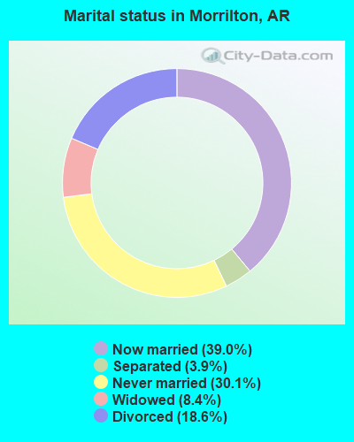
- Never married: 30.1%
- Now married: 39.0%
- Separated: 3.9%
- Widowed: 8.4%
- Divorced: 18.6%
For population 25 years and over in Morrilton:
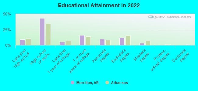
- High school or higher: 89.8%
- Bachelor's degree or higher: 15.6%
- Graduate or professional degree: 3.4%
- Unemployed: 8.0%
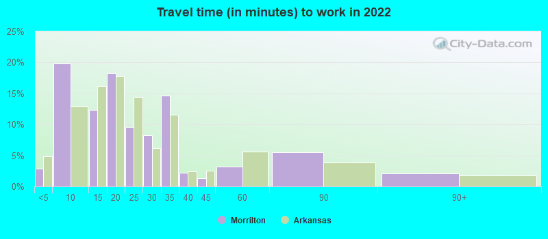
- Mean travel time to work (commute): 20.0 minutes
| Here: | 8.8 |
| Arkansas average: | 11.4 |
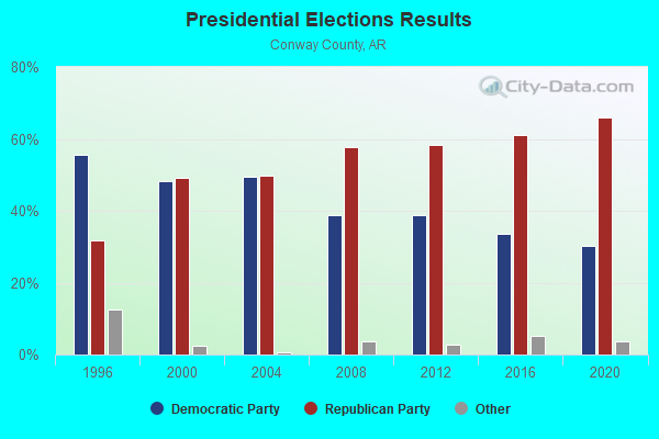
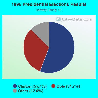
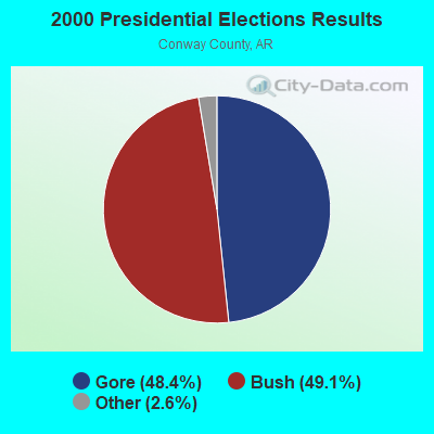
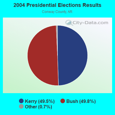
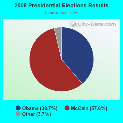
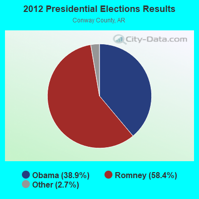
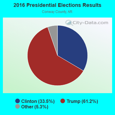
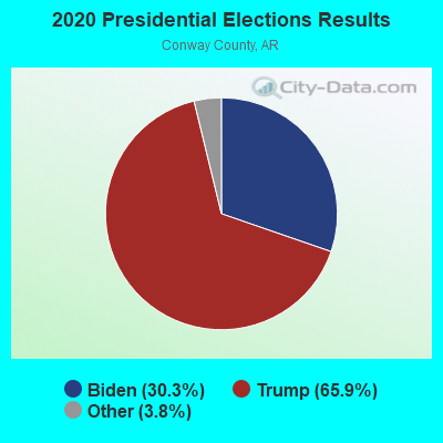
Graphs represent county-level data. Detailed 2008 Election Results
Religion statistics for Morrilton, AR (based on Conway County data)

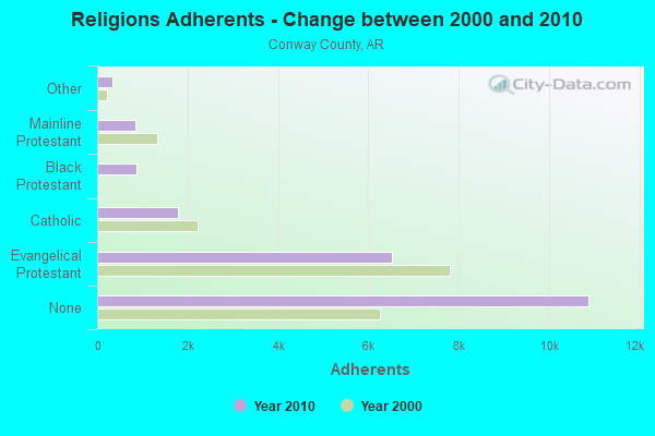
| Religion | Adherents | Congregations |
|---|---|---|
| Evangelical Protestant | 6,533 | 46 |
| Catholic | 1,791 | 4 |
| Black Protestant | 872 | 6 |
| Mainline Protestant | 846 | 8 |
| Other | 345 | 2 |
| None | 10,886 | - |
Food Environment Statistics:
| Here: | 2.41 / 10,000 pop. |
| Arkansas: | 2.02 / 10,000 pop. |
| This county: | 0.48 / 10,000 pop. |
| Arkansas: | 0.25 / 10,000 pop. |
| Conway County: | 0.48 / 10,000 pop. |
| State: | 0.59 / 10,000 pop. |
| Here: | 8.69 / 10,000 pop. |
| Arkansas: | 4.94 / 10,000 pop. |
| Here: | 5.31 / 10,000 pop. |
| Arkansas: | 6.66 / 10,000 pop. |
| This county: | 9.3% |
| Arkansas: | 9.8% |
| This county: | 28.8% |
| State: | 29.1% |
| Conway County: | 16.7% |
| Arkansas: | 13.6% |
Health and Nutrition:
| Morrilton: | 48.7% |
| Arkansas: | 48.2% |
| Morrilton: | 44.7% |
| Arkansas: | 44.2% |
| Morrilton: | 29.0 |
| Arkansas: | 28.9 |
| Morrilton: | 19.5% |
| Arkansas: | 21.6% |
| Morrilton: | 12.1% |
| Arkansas: | 11.3% |
| Morrilton: | 6.8 |
| Arkansas: | 6.8 |
| Morrilton: | 34.6% |
| Arkansas: | 34.0% |
| Morrilton: | 54.1% |
| State: | 54.4% |
| Morrilton: | 76.9% |
| State: | 78.0% |
More about Health and Nutrition of Morrilton, AR Residents
| Local government employment and payroll (March 2022) | |||||
| Function | Full-time employees | Monthly full-time payroll | Average yearly full-time wage | Part-time employees | Monthly part-time payroll |
|---|---|---|---|---|---|
| Police Protection - Officers | 25 | $110,674 | $53,124 | 0 | $0 |
| Streets and Highways | 11 | $37,836 | $41,276 | 0 | $0 |
| Solid Waste Management | 8 | $29,497 | $44,246 | 1 | $2,214 |
| Other Government Administration | 4 | $6,833 | $20,499 | 7 | $2,990 |
| Parks and Recreation | 4 | $13,115 | $39,345 | 16 | $9,619 |
| Sewerage | 3 | $14,202 | $56,808 | 0 | $0 |
| Police - Other | 3 | $9,061 | $36,244 | 1 | $312 |
| Financial Administration | 2 | $6,816 | $40,896 | 1 | $753 |
| Other and Unallocable | 1 | $4,617 | $55,404 | 0 | $0 |
| Judicial and Legal | 1 | $3,914 | $46,968 | 1 | $1,563 |
| Firefighters | 0 | $0 | 24 | $12,452 | |
| Airports | 0 | $0 | 2 | $3,512 | |
| Totals for Government | 62 | $236,565 | $45,787 | 53 | $33,416 |
Morrilton government finances - Expenditure in 2017 (per resident):
- Construction - Air Transportation: $196,000 ($27.69)
- Current Operations - Police Protection: $2,095,000 ($295.95)
Solid Waste Management: $1,230,000 ($173.75)
Regular Highways: $1,001,000 ($141.40)
Sewerage: $514,000 ($72.61)
Parks and Recreation: $475,000 ($67.10)
Financial Administration: $419,000 ($59.19)
Central Staff Services: $419,000 ($59.19)
Local Fire Protection: $410,000 ($57.92)
Air Transportation: $132,000 ($18.65)
Judicial and Legal Services: $19,000 ($2.68)
Public Welfare - Other: $8,000 ($1.13)
Health - Other: $6,000 ($0.85)
- General - Interest on Debt: $4,000 ($0.57)
- Other Capital Outlay - Solid Waste Management: $5,000 ($0.71)
- Total Salaries and Wages: $1,807,000 ($255.26)
Morrilton government finances - Revenue in 2017 (per resident):
- Charges - Solid Waste Management: $1,481,000 ($209.21)
Sewerage: $729,000 ($102.98)
Air Transportation: $110,000 ($15.54)
Parks and Recreation: $92,000 ($13.00)
Other: $20,000 ($2.83)
- Federal Intergovernmental - Air Transportation: $108,000 ($15.26)
General Local Government Support: $41,000 ($5.79)
- Local Intergovernmental - General Local Government Support: $860,000 ($121.49)
- Miscellaneous - General Revenue - Other: $324,000 ($45.77)
Fines and Forfeits: $266,000 ($37.58)
Interest Earnings: $86,000 ($12.15)
- State Intergovernmental - Highways: $339,000 ($47.89)
Other: $189,000 ($26.70)
General Local Government Support: $146,000 ($20.62)
- Tax - General Sales and Gross Receipts: $2,043,000 ($288.60)
Public Utilities Sales: $520,000 ($73.46)
Property: $442,000 ($62.44)
Other License: $29,000 ($4.10)
Morrilton government finances - Debt in 2017 (per resident):
- Long Term Debt - Beginning Outstanding - Unspecified Public Purpose: $87,000 ($12.29)
Retired Unspecified Public Purpose: $45,000 ($6.36)
Outstanding Unspecified Public Purpose: $42,000 ($5.93)
Morrilton government finances - Cash and Securities in 2017 (per resident):
- Other Funds - Cash and Securities: $2,152,000 ($304.00)
| Businesses in Morrilton, AR | ||||
| Name | Count | Name | Count | |
|---|---|---|---|---|
| AT&T | 1 | McDonald's | 1 | |
| Ace Hardware | 1 | Nike | 1 | |
| Curves | 1 | Pizza Hut | 1 | |
| Days Inn | 1 | SONIC Drive-In | 1 | |
| FedEx | 1 | Subway | 2 | |
| Ford | 1 | Super 8 | 1 | |
| H&R Block | 1 | U-Haul | 1 | |
| Hardee's | 1 | UPS | 1 | |
| Jones New York | 1 | Waffle House | 1 | |
| Kroger | 1 | Walmart | 1 | |
| La-Z-Boy | 1 | Wendy's | 1 | |
| Lane Furniture | 1 | |||
Strongest AM radio stations in Morrilton:
- KVOM (800 AM; 0 kW; MORRILTON, AR; Owner: MMA LICENSE LLC)
- KGHT (880 AM; 50 kW; SHERIDAN, AR; Owner: METROPOLITAN RADIO GROUP, INC.)
- KAAY (1090 AM; 50 kW; LITTLE ROCK, AR; Owner: CITADEL BROADCASTING COMPANY)
- KMTL (760 AM; daytime; 10 kW; SHERWOOD, AR; Owner: GEORGE V. DOMERESE)
- KCAB (980 AM; 5 kW; DARDANELLE, AR; Owner: MMA LICENSE LLC)
- KGFL (1110 AM; daytime; 5 kW; CLINTON, AR; Owner: KING-SULIVAN RADIO)
- KARN (920 AM; 5 kW; LITTLE ROCK, AR; Owner: CITADEL BROADCASTING COMPANY)
- KBHS (590 AM; 5 kW; HOT SPRINGS, AR; Owner: J & A, INC.)
- KDXE (1380 AM; 5 kW; NORTH LITTLE ROCK, AR; Owner: RADIO DISNEY AM 1380, LLC)
- KCON (1230 AM; 1 kW; CONWAY, AR; Owner: BOARD OF TRUSTEE OF THE UNIV. OF CEN)
- WCRV (640 AM; 50 kW; COLLIERVILLE, TN; Owner: BOTT BROADCASTING COMPANY/TENNESSEE)
- KLRG (1150 AM; 5 kW; NORTH LITTLE ROCK, AR; Owner: ARKANSAS RADIO CORPORATION)
- KARV (610 AM; 1 kW; RUSSELLVILLE, AR; Owner: KERM, INC.)
Strongest FM radio stations in Morrilton:
- KVOM-FM (101.7 FM; MORRILTON, AR; Owner: MMA LICENSE LLC)
- KSSN (95.7 FM; LITTLE ROCK, AR; Owner: CLEAR CHANNEL BROADCASTING LICENSES, INC.)
- KKPT (94.1 FM; LITTLE ROCK, AR; Owner: SIGNAL MEDIA OF ARKANSAS, INC.)
- KVLD (99.3 FM; ATKINS, AR; Owner: MMA LICENSE LLC)
- KABZ (103.7 FM; LITTLE ROCK, AR; Owner: SIGNAL MEDIA OF ARKANSAS, INC)
- KURB (98.5 FM; LITTLE ROCK, AR; Owner: CITADEL BROADCASTING COMPANY)
- KCJC (102.3 FM; DARDANELLE, AR; Owner: MMA LICENSE LLC)
- KDJE (100.3 FM; JACKSONVILLE, AR; Owner: CLEAR CHANNEL BROADCASTING LICENSES, INC.)
- KMJX (105.1 FM; CONWAY, AR; Owner: CLEAR CHANNEL BROADCASTING LICENSES, INC.)
- K207CW (89.3 FM; PARIS, AR; Owner: CALVARY CHAPEL OF TWIN FALLS, INC.)
- KUAR (89.1 FM; LITTLE ROCK, AR; Owner: BD. OF TRUSTEES OF UNIV. OF ARKANSAS)
- KHKN (106.7 FM; BENTON, AR; Owner: CLEAR CHANNEL BROADCASTING LICENSES, INC.)
- KARV-FM (101.3 FM; OLA, AR; Owner: KERM INC)
- KABF (88.3 FM; LITTLE ROCK, AR; Owner: ARKANSAS BROADCASTING FOUNDATION INC)
- KMSX (94.9 FM; MAUMELLE, AR; Owner: CLEAR CHANNEL BROADCASTING LICENSES, INC.)
- KSBC (90.1 FM; HOT SPRINGS, AR; Owner: CENTRAL ARKANSAS CHRISTIAN BROADCASTING, INC.)
- KLAL (107.7 FM; WRIGHTSVILLE, AR; Owner: CITADEL BROADCASTING COMPANY)
- KASR (92.7 FM; CONWAY, AR; Owner: CREATIVE MEDIA INCORPORATED)
- KUCA (91.3 FM; CONWAY, AR; Owner: UNIVERSITY OF CENTRAL ARKANSAS)
TV broadcast stations around Morrilton:
- KTHV (Channel 11; LITTLE ROCK, AR; Owner: ARKANSAS TELEVISION COMPANY)
- KLRT-TV (Channel 16; LITTLE ROCK, AR; Owner: CLEAR CHANNEL BROADCASTING LICENSES, INC.)
- KARK-TV (Channel 4; LITTLE ROCK, AR; Owner: KARK-TV, INC.)
- KATV (Channel 7; LITTLE ROCK, AR; Owner: KATV, LLC)
- KWBF (Channel 42; LITTLE ROCK, AR; Owner: RIVER CITY BROADCASTING, INC.)
- KKYK-LP (Channel 22; LITTLE ROCK, AR; Owner: ARKANSAS 49, INC.)
- KETS (Channel 2; LITTLE ROCK, AR; Owner: ARKANSAS EDUCATIONAL TELEVISION COMMISSION)
- KHTE-LP (Channel 44; LITTLE ROCK, AR; Owner: EQUITY BROADCASTING CORPORATION)
- KASN (Channel 38; PINE BLUFF, AR; Owner: CLEAR CHANNEL BROADCASTING LICENSES, INC.)
- K27FF (Channel 27; EL DORADO, AR; Owner: MS COMMUNICATIONS, LLC)
- KLRA-LP (Channel 58; LITTLE ROCK, AR; Owner: ARKANSAS MEDIA, L.L.C.)
- K34FH (Channel 34; LITTLE ROCK, AR; Owner: NATIONAL MINORITY T.V., INC.)
- KHUG-LP (Channel 14; LITTLE ROCK, AR; Owner: LITTLE ROCK TV-14, L.L.C.)
Medal of Honor Recipients
Medal of Honor Recipient born in Morrilton: Nathan Green Gordon.
- National Bridge Inventory (NBI) Statistics
- 42Number of bridges
- 568ft / 173mTotal length
- $1,541,000Total costs
- 339,137Total average daily traffic
- 16,270Total average daily truck traffic
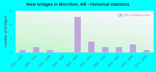
- New bridges - historical statistics
- 11920-1929
- 21930-1939
- 11940-1949
- 131960-1969
- 41970-1979
- 21980-1989
- 21990-1999
- 32000-2009
- 12010-2019
FCC Registered Cell Phone Towers:
2 (See the full list of FCC Registered Cell Phone Towers in Morrilton)FCC Registered Antenna Towers:
170 (See the full list of FCC Registered Antenna Towers)FCC Registered Commercial Land Mobile Towers:
1 (See the full list of FCC Registered Commercial Land Mobile Towers in Morrilton, AR)FCC Registered Private Land Mobile Towers:
5 (See the full list of FCC Registered Private Land Mobile Towers)FCC Registered Broadcast Land Mobile Towers:
13 (See the full list of FCC Registered Broadcast Land Mobile Towers)FCC Registered Microwave Towers:
12 (See the full list of FCC Registered Microwave Towers in this town)FCC Registered Paging Towers:
2 (See the full list of FCC Registered Paging Towers)FCC Registered Maritime Coast & Aviation Ground Towers:
4 (See the full list of FCC Registered Maritime Coast & Aviation Ground Towers)FCC Registered Amateur Radio Licenses:
80 (See the full list of FCC Registered Amateur Radio Licenses in Morrilton)FAA Registered Aircraft Manufacturers and Dealers:
1- PRICE KIRK, Po Box 476, Morrilton, AR 72110
Certificate: D001752 (Individual), Certificate Issue Date: 06/09/2009, Expiration Date: 06/08/2010
FAA Registered Aircraft:
6- Aircraft: AERONCA 7AC (Category: Land, Seats: 2, Weight: Up to 12,499 Pounds, Speed: 90 mph), Engine: CONT MOTOR A&C65 SERIES (65 HP) (Reciprocating)
N-Number: 1818E, N1818E, N-1818E, Serial Number: 7AC-5385, Year manufactured: 1946, Airworthiness Date: 11/11/1955, Certificate Issue Date: 01/25/2018
Registrant (Co-Owned): Kirk E Price, 5 Green Ln, Morrilton, AR 72110, Other Owners: Jeannie Price - Aircraft: POWRACHUTE CORP PEGASUS (Category: Land, Seats: 2, Weight: Up to 12,499 Pounds), Engine: ROTAX 582SER (65 HP) (2 Cycle)
N-Number: 3101L, N3101L, N-3101L, Serial Number: A331PEG, Year manufactured: 2006, Airworthiness Date: 04/29/2008, Certificate Issue Date: 02/03/2014
Registrant (Individual): Danny R Bryant, 344 Mount Zion Loop, Morrilton, AR 72110 - Aircraft: BOEING B75N1 (Category: Land, Seats: 2, Weight: Up to 12,499 Pounds, Speed: 93 mph), Engine: CONT MOTOR W670 SERIES (250 HP) (Reciprocating)
N-Number: 4439N, N4439N, N-4439N, Serial Number: 756959, Year manufactured: 1942, Airworthiness Date: 05/07/1991, Certificate Issue Date: 03/08/1990
Registrant (Individual): Willian C Iii Brickey, 3378 Highway 154, Morrilton, AR 72110 - Aircraft: CESSNA 172P (Category: Land, Seats: 4, Weight: Up to 12,499 Pounds), Engine: LYCOMING 0-320 SERIES (180 HP) (Reciprocating)
N-Number: 54171, N54171, N-54171, Serial Number: 17274901, Year manufactured: 1981, Airworthiness Date: 04/16/1981, Certificate Issue Date: 01/07/2009
Registrant (LLC): Ruff Air LLC, 51 Blue Diamond Dr, Morrilton, AR 72110 - Aircraft: CESSNA 172G (Category: Land, Seats: 4, Weight: Up to 12,499 Pounds, Speed: 105 mph), Engine: CONT MOTOR 0-300 SER (145 HP) (Reciprocating)
N-Number: 5744R, N5744R, N-5744R, Serial Number: 17253413, Airworthiness Date: 09/21/1965, Certificate Issue Date: 10/10/2019
Registrant (Individual): Keith Linn, Po Box 116, Morrilton, AR 72110 - Aircraft: BEECH C35 (Category: Land, Seats: 4, Weight: Up to 12,499 Pounds, Speed: 120 mph), Engine: CONT MOTOR E185 SERIES (205 HP) (Reciprocating)
N-Number: 5925C, N5925C, N-5925C, Serial Number: D-3284, Year manufactured: 1952, Airworthiness Date: 08/08/1956, Certificate Issue Date: 05/26/2006
Registrant (Individual): William C Brickey, 3378 Highway 154, Morrilton, AR 72110
2003 - 2018 National Fire Incident Reporting System (NFIRS) incidents
- Fire incident types reported to NFIRS in Morrilton, AR
- 71450.2%Outside Fires
- 46232.5%Structure Fires
- 20514.4%Mobile Property/Vehicle Fires
- 412.9%Other
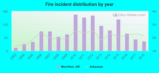 According to the data from the years 2003 - 2018 the average number of fire incidents per year is 89. The highest number of fires - 166 took place in 2010, and the least - 16 in 2003. The data has a rising trend.
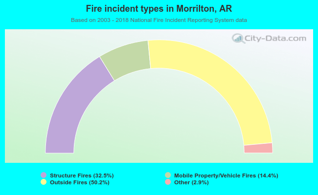 When looking into fire subcategories, the most incidents belonged to: Outside Fires (50.2%), and Structure Fires (32.5%).
Fire-safe hotels and motels in Morrilton, Arkansas:
- Americas Best Value Inn, 356 Arkansas 95 N, Morrilton, Arkansas 72110 , Phone: (501) 354-0181, Fax: (501) 354-1458
- Holiday Inn Express & Suites, 8 Bruce St, Morrilton, Arkansas 72110 , Phone: (501) 215-4924, Fax: (501) 215-4923
- Days Inn Morrilton, 1506 N Oak St, Morrilton, Arkansas 72110 , Phone: (501) 354-5101, Fax: (501) 354-8539
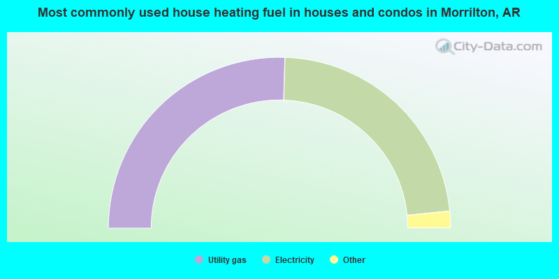
- 51.1%Utility gas
- 45.8%Electricity
- 1.9%Bottled, tank, or LP gas
- 1.2%Wood
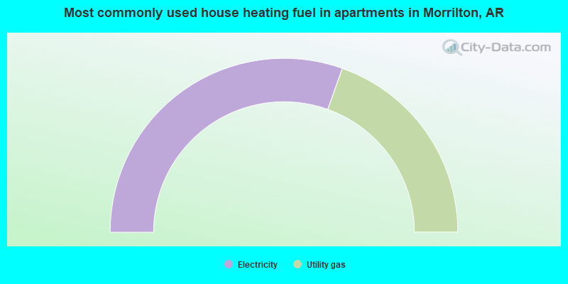
- 60.9%Electricity
- 39.1%Utility gas
Morrilton compared to Arkansas state average:
- Unemployed percentage below state average.
- Length of stay since moving in above state average.
- House age above state average.
- Institutionalized population percentage above state average.
Morrilton on our top lists:
- #26 on the list of "Top 101 cities with the largest percentage of divorced people (15+ years)(population 5,000+)"
- #92 on the list of "Top 101 counties with the smallest number of children under 18 without health insurance coverage in 2000"

|
Total of 3 patent applications in 2008-2024.