Montpelier, Wisconsin
Submit your own pictures of this town and show them to the world
- OSM Map
- Google Map
- MSN Map
Population change since 2000: -4.7%
 |
| Males: 694 | |
| Females: 612 |
| Median resident age: | 42.2 years |
| Wisconsin median age: | 42.6 years |
Zip codes: 54217.
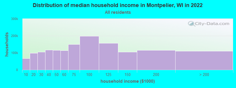
| Montpelier: | $88,496 |
| WI: | $70,996 |
Estimated per capita income in 2022: $40,864 (it was $19,812 in 2000)
Montpelier town income, earnings, and wages data
Estimated median house or condo value in 2022: $248,742 (it was $112,000 in 2000)
| Montpelier: | $248,742 |
| WI: | $252,800 |
Detailed information about poverty and poor residents in Montpelier, WI


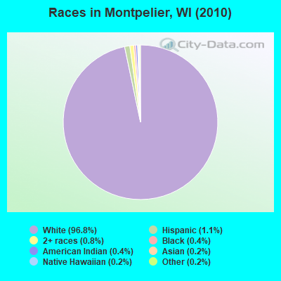
- 1,26496.8%White alone
- 151.1%Hispanic
- 110.8%Two or more races
- 50.4%Black alone
- 50.4%American Indian alone
- 20.2%Asian alone
- 20.2%Native Hawaiian and Other
Pacific Islander alone - 20.2%Other race alone
Races in Montpelier detailed stats: ancestries, foreign born residents, place of birth
 Recent articles from our blog. Our writers, many of them Ph.D. graduates or candidates, create easy-to-read articles on a wide variety of topics.
Ancestries: German (41.6%), Czech (21.4%), Polish (7.6%), Dutch (4.0%), Irish (3.1%), United States (2.0%).
Current Local Time: CST time zone
Land area: 36.2 square miles.
Population density: 36 people per square mile (very low).
5 residents are foreign born
| This town: | 0.4% |
| Wisconsin: | 3.6% |
| Montpelier town: | 1.5% ($1,715) |
| Wisconsin: | 2.0% ($2,245) |
Nearest city with pop. 50,000+: Green Bay, WI  (15.8 miles , pop. 102,313).
Nearest city with pop. 200,000+: Milwaukee, WI (97.9 miles , pop. 596,974).
Nearest city with pop. 1,000,000+: Chicago, IL (180.9 miles , pop. 2,896,016).
Nearest cities:
), ), ), ), ), ), ), )Latitude: 44.46 N, Longitude: 87.71 W
Area code commonly used in this area: 920
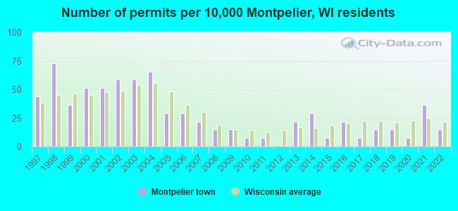
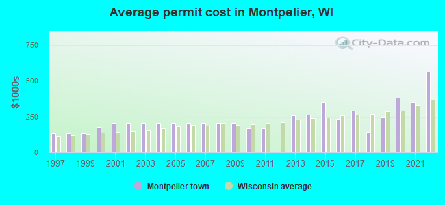
Single-family new house construction building permits:
- 2022: 2 buildings, average cost: $562,500
- 2021: 5 buildings, average cost: $350,000
- 2020: 1 building, cost: $380,000
- 2019: 2 buildings, average cost: $248,000
- 2018: 2 buildings, average cost: $143,800
- 2017: 1 building, cost: $290,000
- 2016: 3 buildings, average cost: $231,300
- 2015: 1 building, cost: $350,000
- 2014: 4 buildings, average cost: $263,300
- 2013: 3 buildings, average cost: $258,300
- 2011: 1 building, cost: $168,100
- 2010: 1 building, cost: $168,100
- 2009: 2 buildings, average cost: $206,600
- 2008: 2 buildings, average cost: $206,600
- 2007: 3 buildings, average cost: $206,600
- 2006: 4 buildings, average cost: $206,600
- 2005: 4 buildings, average cost: $206,600
- 2004: 9 buildings, average cost: $206,600
- 2003: 8 buildings, average cost: $206,600
- 2002: 8 buildings, average cost: $206,600
- 2001: 7 buildings, average cost: $206,100
- 2000: 7 buildings, average cost: $178,000
- 1999: 5 buildings, average cost: $132,000
- 1998: 10 buildings, average cost: $135,000
- 1997: 6 buildings, average cost: $130,500
| Here: | 2.3% |
| Wisconsin: | 2.7% |
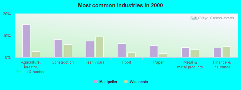
- Agriculture, forestry, fishing & hunting (15.2%)
- Construction (8.3%)
- Health care (7.5%)
- Food (6.4%)
- Paper (5.6%)
- Metal & metal products (4.6%)
- Finance & insurance (4.5%)
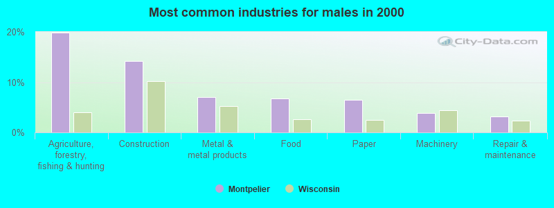
- Agriculture, forestry, fishing & hunting (19.8%)
- Construction (14.3%)
- Metal & metal products (7.0%)
- Food (6.8%)
- Paper (6.5%)
- Machinery (3.9%)
- Repair & maintenance (3.1%)
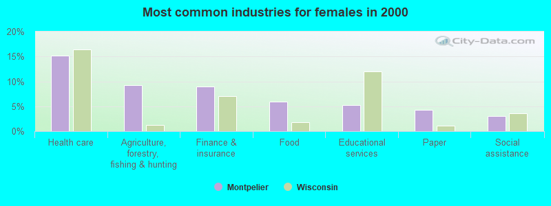
- Health care (15.1%)
- Agriculture, forestry, fishing & hunting (9.3%)
- Finance & insurance (9.0%)
- Food (5.9%)
- Educational services (5.2%)
- Paper (4.3%)
- Social assistance (3.1%)
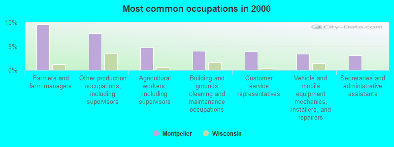
- Farmers and farm managers (9.6%)
- Other production occupations, including supervisors (7.7%)
- Agricultural workers, including supervisors (4.7%)
- Building and grounds cleaning and maintenance occupations (4.1%)
- Customer service representatives (3.9%)
- Vehicle and mobile equipment mechanics, installers, and repairers (3.4%)
- Secretaries and administrative assistants (3.1%)
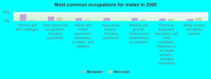
- Farmers and farm managers (12.8%)
- Other production occupations, including supervisors (8.2%)
- Vehicle and mobile equipment mechanics, installers, and repairers (6.0%)
- Agricultural workers, including supervisors (6.0%)
- Building and grounds cleaning and maintenance occupations (5.8%)
- Electrical equipment mechanics and other installation, maintenance, and repair workers, including supervisors (5.1%)
- Metal workers and plastic workers (4.1%)
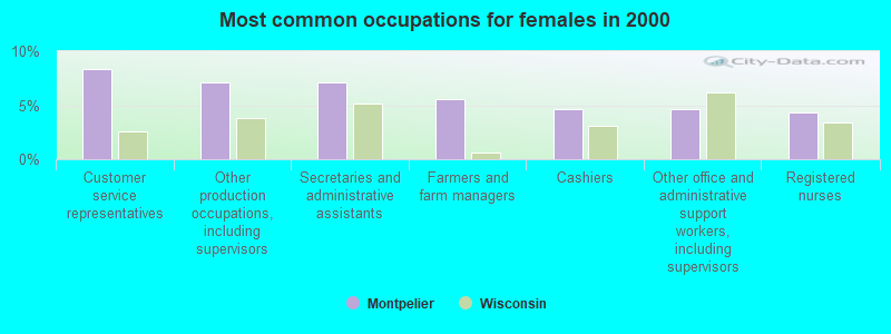
- Customer service representatives (8.3%)
- Other production occupations, including supervisors (7.1%)
- Secretaries and administrative assistants (7.1%)
- Farmers and farm managers (5.6%)
- Cashiers (4.6%)
- Other office and administrative support workers, including supervisors (4.6%)
- Registered nurses (4.3%)
Average climate in Montpelier, Wisconsin
Based on data reported by over 4,000 weather stations


(lower is better)
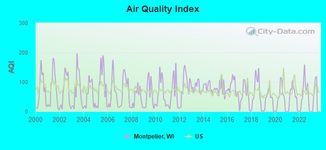
Air Quality Index (AQI) level in 2022 was 53.5. This is better than average.
| City: | 53.5 |
| U.S.: | 72.6 |
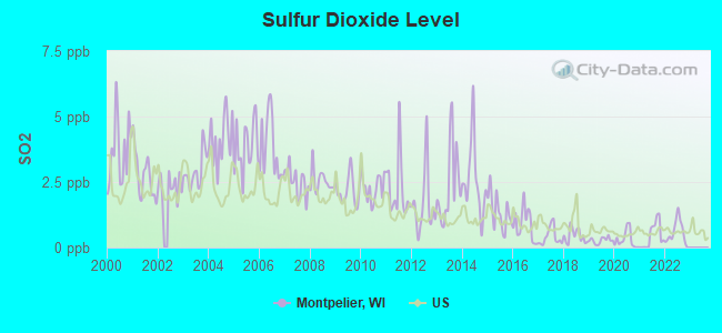
Sulfur Dioxide (SO2) [ppb] level in 2022 was 0.556. This is significantly better than average. Closest monitor was 11.4 miles away from the city center.
| City: | 0.556 |
| U.S.: | 1.515 |
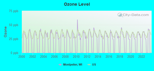
Ozone [ppb] level in 2022 was 32.0. This is about average. Closest monitor was 9.3 miles away from the city center.
| City: | 32.0 |
| U.S.: | 33.3 |
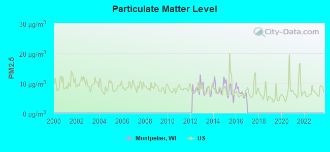
Particulate Matter (PM2.5) [µg/m3] level in 2016 was 6.90. This is about average. Closest monitor was 11.2 miles away from the city center.
| City: | 6.90 |
| U.S.: | 8.11 |
Tornado activity:
Montpelier-area historical tornado activity is below Wisconsin state average. It is 23% smaller than the overall U.S. average.
On 7/5/1994, a category F4 (max. wind speeds 207-260 mph) tornado 9.9 miles away from the Montpelier town center injured 2 people and caused between $500,000 and $5,000,000 in damages.
On 4/27/1984, a category F4 tornado 29.3 miles away from the town center killed one person and injured 19 people and caused between $500,000 and $5,000,000 in damages.
Earthquake activity:
Montpelier-area historical earthquake activity is significantly above Wisconsin state average. It is 27% smaller than the overall U.S. average.On 5/2/2015 at 16:23:07, a magnitude 4.2 (4.2 MW, Depth: 2.8 mi, Class: Light, Intensity: IV - V) earthquake occurred 191.6 miles away from Montpelier center
On 4/18/2008 at 09:36:59, a magnitude 5.4 (5.1 MB, 4.8 MS, 5.4 MW, 5.2 MW, Class: Moderate, Intensity: VI - VII) earthquake occurred 415.3 miles away from Montpelier center
On 6/28/2004 at 06:10:52, a magnitude 4.2 (4.2 MW, Depth: 6.2 mi) earthquake occurred 215.8 miles away from Montpelier center
On 6/10/1987 at 23:48:54, a magnitude 5.1 (4.9 MB, 4.4 MS, 4.6 MS, 5.1 LG) earthquake occurred 389.8 miles away from Montpelier center
On 4/18/2008 at 09:36:59, a magnitude 5.2 (5.2 MW, Depth: 8.9 mi) earthquake occurred 415.4 miles away from Montpelier center
On 1/31/1986 at 16:46:43, a magnitude 5.0 (5.0 MB) earthquake occurred 385.2 miles away from Montpelier center
Magnitude types: regional Lg-wave magnitude (LG), body-wave magnitude (MB), surface-wave magnitude (MS), moment magnitude (MW)
Natural disasters:
The number of natural disasters in Kewaunee County (6) is a lot smaller than the US average (15).Major Disasters (Presidential) Declared: 3
Emergencies Declared: 3
Causes of natural disasters: Floods: 2, Storms: 2, Drought: 1, Hurricane: 1, Tornado: 1, Winter Storm: 1, Other: 1 (Note: some incidents may be assigned to more than one category).
Hospitals and medical centers near Montpelier:
- KEWAUNEE CARE CTR (Nursing Home, about 10 miles away; KEWAUNEE, WI)
- KEWAUNEE HEALTH CARE CENTER (Nursing Home, about 10 miles away; KEWAUNEE, WI)
- ST MARYS KEWAUNEE AREA MEM HOSPITAL (Hospital, about 10 miles away; KEWAUNEE, WI)
- AURORA VISITING NURSE ASSOCIATION OF WI (Home Health Center, about 11 miles away; GREEN BAY, WI)
- AURORA BAYCARE MED CTR Acute Care Hospitals (about 12 miles away; GREEN BAY, WI)
- BAYCARE SURG CTR EAST (Hospital, about 12 miles away; GREEN BAY, WI)
- BROWN CO HEALTH CARE CTR (Nursing Home, about 13 miles away; GREEN BAY, WI)
Operable nuclear power plant near Montpelier:
- 9 miles: Kewaunee in Carlton, WI.
Colleges/universities with over 2000 students nearest to Montpelier:
- University of Wisconsin-Green Bay (about 12 miles; Green Bay, WI; Full-time enrollment: 5,415)
- Saint Norbert College (about 18 miles; De Pere, WI; FT enrollment: 2,324)
- Northeast Wisconsin Technical College (about 21 miles; Green Bay, WI; FT enrollment: 6,069)
- Lawrence University (about 37 miles; Appleton, WI; FT enrollment: 2,821)
- Fox Valley Technical College (about 40 miles; Appleton, WI; FT enrollment: 5,682)
- Lakeland College (about 44 miles; Plymouth, WI; FT enrollment: 2,395)
- University of Wisconsin-Oshkosh (about 52 miles; Oshkosh, WI; FT enrollment: 10,637)
Points of interest:
Notable locations in Montpelier: Buresh Farms (A), Davister Farm (B), Fairview Farms (C), White Ledge Dairy (D), Rolling Hills Dairy Farm (E), School Lane Dairy (F), Martyville Dairy (G), Salzsieder Farms (H). Display/hide their locations on the map
Churches in Montpelier include: Saint Joseph Catholic Church (A), Saint Pauls Lutheran Church (B). Display/hide their locations on the map
Cemeteries: Saint Wenceslaus Cemetery (1), Montpelier Township Cemetery (2), Saint Josephs Catholic Cemetery (3), Saint Paul Lutheran Cemetery (4), Zion Cemetery (5), Saint Anna Cemetery (6). Display/hide their locations on the map
Lake: Hallada Lake (A). Display/hide its location on the map
| This town: | 2.6 people |
| Wisconsin: | 2.4 people |
| This town: | 74.3% |
| Whole state: | 64.4% |
| This town: | 4.6% |
| Whole state: | 7.3% |
Likely homosexual households (counted as self-reported same-sex unmarried-partner households)
- Lesbian couples: 0.0% of all households
- Gay men: 0.2% of all households
| This town: | 3.8% |
| Whole state: | 8.7% |
| This town: | 2.5% |
| Whole state: | 3.7% |
For population 15 years and over in Montpelier:
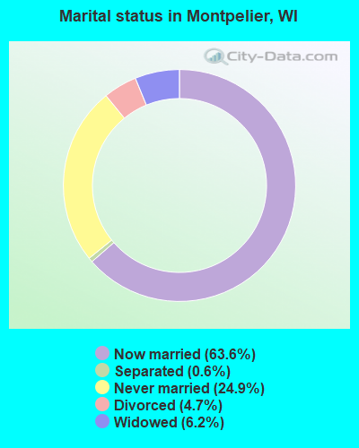
- Never married: 24.9%
- Now married: 63.6%
- Separated: 0.6%
- Widowed: 6.2%
- Divorced: 4.7%
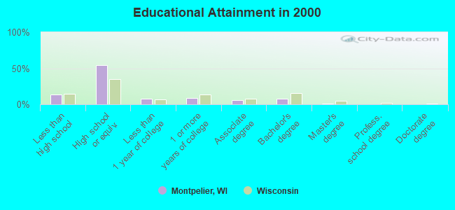
For population 25 years and over in Montpelier:
- High school or higher: 86.4%
- Bachelor's degree or higher: 9.9%
- Graduate or professional degree: 1.7%
- Unemployed: 2.0%
- Mean travel time to work (commute): 23.8 minutes
| Here: | 8.5 |
| Wisconsin average: | 11.0 |
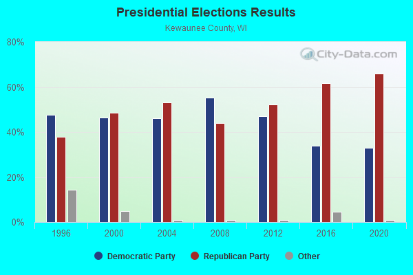
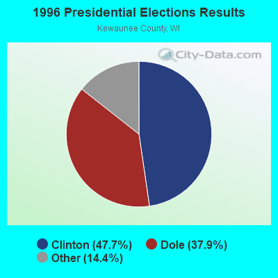
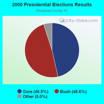
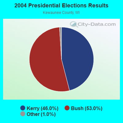
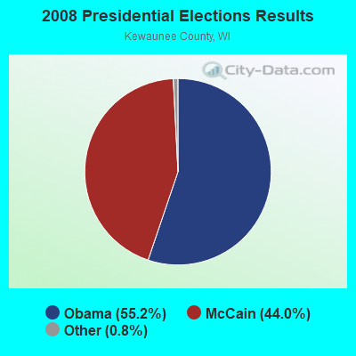
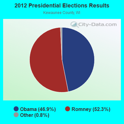
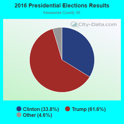
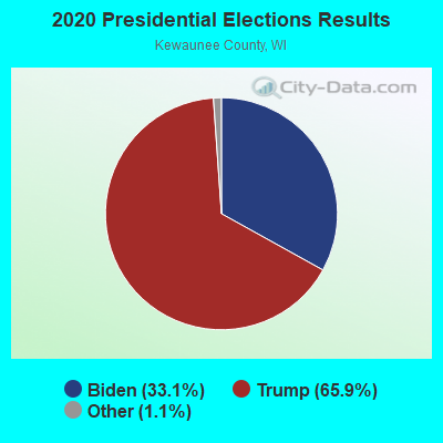
Graphs represent county-level data. Detailed 2008 Election Results
Religion statistics for Montpelier, WI (based on Kewaunee County data)
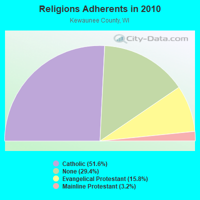
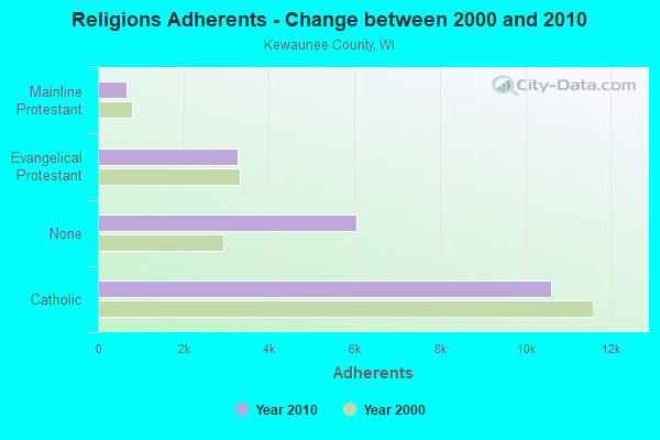
| Religion | Adherents | Congregations |
|---|---|---|
| Catholic | 10,606 | 7 |
| Evangelical Protestant | 3,257 | 10 |
| Mainline Protestant | 663 | 5 |
| Other | 8 | 1 |
| None | 6,040 | - |
Food Environment Statistics:
| Kewaunee County: | 2.44 / 10,000 pop. |
| Wisconsin: | 1.86 / 10,000 pop. |
| This county: | 6.35 / 10,000 pop. |
| Wisconsin: | 4.12 / 10,000 pop. |
| Kewaunee County: | 11.73 / 10,000 pop. |
| Wisconsin: | 8.64 / 10,000 pop. |
| Here: | 7.9% |
| Wisconsin: | 7.6% |
| Here: | 29.9% |
| Wisconsin: | 27.5% |
| This county: | 14.5% |
| Wisconsin: | 13.0% |
Strongest AM radio stations in Montpelier:
- WTAQ (1360 AM; 10 kW; GREEN BAY, WI; Owner: MIDWEST COMMUNICATIONS, INC.)
- WNAM (1280 AM; 50 kW; NEENAH-MENASHA, WI; Owner: CUMULUS LICENSING CORP.)
- WNFL (1440 AM; 5 kW; GREEN BAY, WI; Owner: MIDWEST COMMUNICATIONS, INC.)
- WHBY (1150 AM; 25 kW; KIMBERLY, WI; Owner: WOODWARD COMMUNICATIONS, INC.)
- WCUB (980 AM; 5 kW; TWO RIVERS, WI; Owner: CUB RADIO, INC.)
- WSPT (1010 AM; 50 kW; STEVENS POINT, WI)
- WTCM (580 AM; 35 kW; TRAVERSE CITY, MI; Owner: WTCM RADIO, INC.)
- WTMJ (620 AM; 50 kW; MILWAUKEE, WI; Owner: JOURNAL BROADCAST CORPORATION)
- WLDR (1210 AM; daytime; 50 kW; KINGSLEY, MI; Owner: FORT BEND BROADCASTING COMPANY)
- WDUZ (1400 AM; 1 kW; GREEN BAY, WI; Owner: CUMULUS LICENSING CORP.)
- WSAU (550 AM; 20 kW; WAUSAU, WI; Owner: WRIG, INC.)
- WISN (1130 AM; 50 kW; MILWAUKEE, WI; Owner: CAPSTAR TX LIMITED PARTNERSHIP)
- WGN (720 AM; 50 kW; CHICAGO, IL; Owner: WGN CONTINENTAL BROADCASTING CO.)
Strongest FM radio stations in Montpelier:
- WIXX (101.1 FM; GREEN BAY, WI; Owner: MIDWEST COMMUNICATIONS, INC.)
- WEMY (91.5 FM; GREEN BAY, WI; Owner: EVANGEL MINISTRIES, INC)
- WHID (88.1 FM; GREEN BAY, WI; Owner: BD OF REGENTS OF THE UNIV OF WI SYS)
- WAUN-FM (92.7 FM; KEWAUNEE, WI; Owner: MAGNUM BROADCASTING, INC.)
- WPNE-FM (89.3 FM; GREEN BAY, WI; Owner: WISCONSIN EDUCATIONAL COMMUNICATIONS BOARD)
- WXWX (107.5 FM; BRILLION, WI; Owner: CUMULUS LICENSING CORP.)
- WLYD (99.7 FM; STURGEON BAY, WI; Owner: MIDWEST COMMUNICATIONS INC)
- WJLW (106.7 FM; ALLOUEZ, WI; Owner: CUMULUS LICENSING CORP)
- WOGB (103.1 FM; KAUKAUNA, WI; Owner: CUMULUS LICENSING CORP.)
- WKSZ (95.9 FM; DE PERE, WI; Owner: WOODWARD COMMUNICATIONS INC)
- WORQ (90.1 FM; GREEN BAY, WI; Owner: LAKESHORE COMMUNICATIONS, INC.)
- WBDK (96.7 FM; ALGOMA, WI; Owner: NICOLET BROADCASTING, INC.)
- W270AJ (101.9 FM; GREEN BAY, WI; Owner: MIDWEST COMMUNICATIONS, INC)
- WAPL-FM (105.7 FM; APPLETON, WI; Owner: WOODWARD COMMUNICATIONS, INC.)
- WZOR (94.7 FM; MISHICOT, WI; Owner: WOODWARD COMMUNICATIONS, INC.)
- WRLU (104.1 FM; ALGOMA, WI; Owner: NICOLET BROADCASTING, INC.)
- WRKU (102.1 FM; FORESTVILLE, WI; Owner: NICOLET BROADCASTING, INC.)
- WQLH (98.5 FM; GREEN BAY, WI; Owner: CUMULUS LICENSING CORP.)
- WLTU (92.1 FM; MANITOWOC, WI; Owner: CUB RADIO, INC.)
- WPCK (104.9 FM; KAUKAUNA, WI; Owner: MIDWEST DIMENSIONS, INC.)
TV broadcast stations around Montpelier:
- WBAY-TV (Channel 2; GREEN BAY, WI; Owner: YOUNG BROADCASTING OF GREEN BAY, INC.)
- WLUK-TV (Channel 11; GREEN BAY, WI; Owner: EMMIS TELEVISION LICENSE CORPORATION)
- WFRV-TV (Channel 5; GREEN BAY, WI; Owner: CBS BROADCASTING INC.)
- WPNE (Channel 38; GREEN BAY, WI; Owner: WISCONSIN EDUCATIONAL COMMUNICATIONS BOARD)
- WGBA (Channel 26; GREEN BAY, WI; Owner: ARIES TELECOMMUNICATION CORPORATION)
- WACY (Channel 32; APPLETON, WI; Owner: ACE TV, INC.)
- W49CB (Channel 49; GREEN BAY, WI; Owner: TRINITY BROADCASTING NETWORK)
- W30BU (Channel 30; GREEN BAY, WI; Owner: THREE ANGELS BROADCASTING NETWORK)
- WIWB (Channel 14; SURING, WI; Owner: ACME TV LICENSES OF WISCONSIN, LLC)
- WMMF-TV (Channel 68; FOND DU LAC, WI; Owner: PAPPAS TELECASTING OF WISCONSIN, A CALIFORNIA LTD PARTNRSHP)
- National Bridge Inventory (NBI) Statistics
- 5Number of bridges
- 26ft / 7.8mTotal length
- 2,601Total average daily traffic
- 2,858Total future (year 2039) average daily traffic
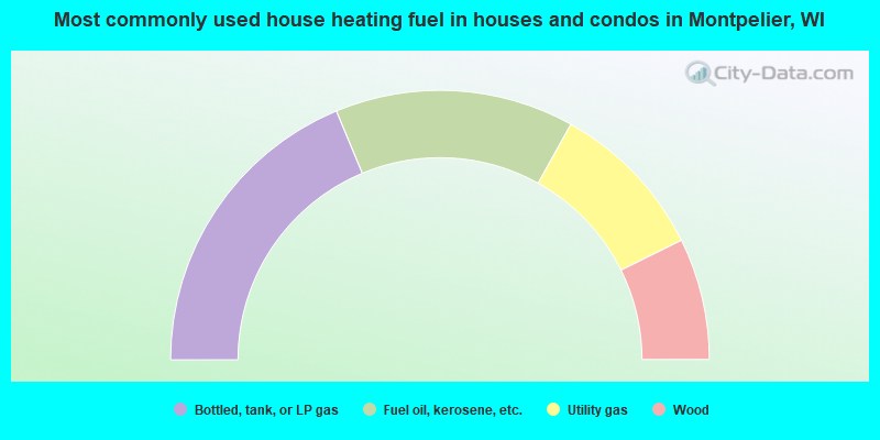
- 37.4%Bottled, tank, or LP gas
- 28.7%Fuel oil, kerosene, etc.
- 19.2%Utility gas
- 14.6%Wood
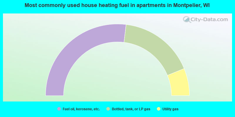
- 53.8%Fuel oil, kerosene, etc.
- 33.8%Bottled, tank, or LP gas
- 12.3%Utility gas
Montpelier compared to Wisconsin state average:
- Unemployed percentage significantly below state average.
- Black race population percentage significantly below state average.
- Hispanic race population percentage significantly below state average.
- Foreign-born population percentage significantly below state average.
- Renting percentage significantly below state average.
- Length of stay since moving in significantly above state average.
- Number of rooms per house significantly below state average.
- House age significantly below state average.
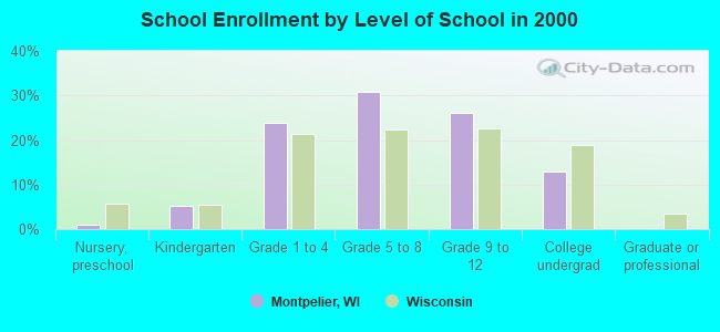
- Number of college students below state average.
- Percentage of population with a bachelor's degree or higher significantly below state average.