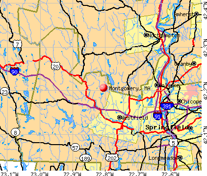
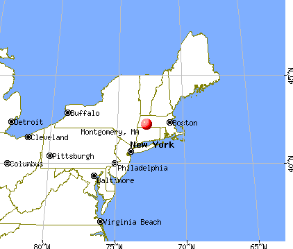
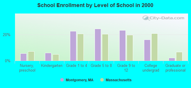
Montgomery, Massachusetts
Submit your own pictures of this town and show them to the world
- OSM Map
- General Map
- Google Map
- MSN Map
Population change since 2000: +28.1%
| Males: 422 | |
| Females: 416 |
| Median resident age: | 46.7 years |
| Massachusetts median age: | 39.2 years |
Zip codes: 01085.
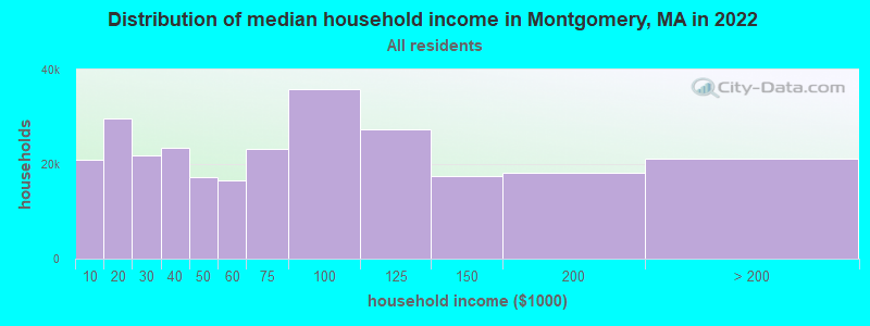
| Montgomery: | $94,972 |
| MA: | $94,488 |
Estimated per capita income in 2022: $45,522 (it was $25,942 in 2000)
Montgomery town income, earnings, and wages data
Estimated median house or condo value in 2022: $399,704 (it was $161,100 in 2000)
| Montgomery: | $399,704 |
| MA: | $534,700 |
Mean prices in 2022: all housing units: $315,253; detached houses: $334,901; townhouses or other attached units: $238,289; in 2-unit structures: $223,248; in 3-to-4-unit structures: $195,645; in 5-or-more-unit structures: $166,405; mobile homes: $156,908
Detailed information about poverty and poor residents in Montgomery, MA


- 80596.1%White alone
- 141.7%Two or more races
- 101.2%Hispanic
- 60.7%American Indian alone
- 30.4%Asian alone
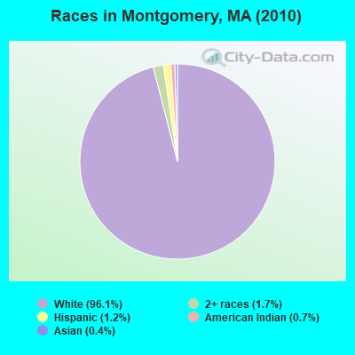
Races in Montgomery detailed stats: ancestries, foreign born residents, place of birth
 Recent articles from our blog. Our writers, many of them Ph.D. graduates or candidates, create easy-to-read articles on a wide variety of topics.


 | MA is Snobby (321 replies) |
| Boston Racial Stigma- is it "cool" to hate on Boston? (632 replies) |
| Oklahoma to (likely Western) Massachusetts - Beginning Research (274 replies) |
| Let’s Go Celtics! (88 replies) |
| MA ranked most prosperous state (123 replies) |
| "All-Inclusive Boston" campaiagn (582 replies) |
Latest news from Montgomery, MA collected exclusively by city-data.com from local newspapers, TV, and radio stations
Ancestries: Irish (17.9%), French (16.2%), Polish (15.6%), English (14.2%), United States (13.9%), German (11.5%).
Current Local Time: EST time zone
Incorporated in 1780
Elevation: 1049 feet
Land area: 15.1 square miles.
Population density: 56 people per square mile (very low).
15 residents are foreign born (0.8% Latin America, 0.6% Europe, 0.3% Asia, 0.3% Oceania, 0.3% North America).
| This town: | 2.3% |
| Massachusetts: | 12.2% |
| Montgomery town: | 1.3% ($2,063) |
| Massachusetts: | 1.3% ($2,336) |
Nearest city with pop. 50,000+: Chicopee, MA  (12.1 miles , pop. 54,653).
Nearest city with pop. 200,000+: Boston, MA (88.8 miles , pop. 589,141).
Nearest city with pop. 1,000,000+: Bronx, NY (109.1 miles , pop. 1,332,650).
Nearest cities:
), ), )Latitude: 42.21 N, Longitude: 72.82 W
Area code commonly used in this area: 413

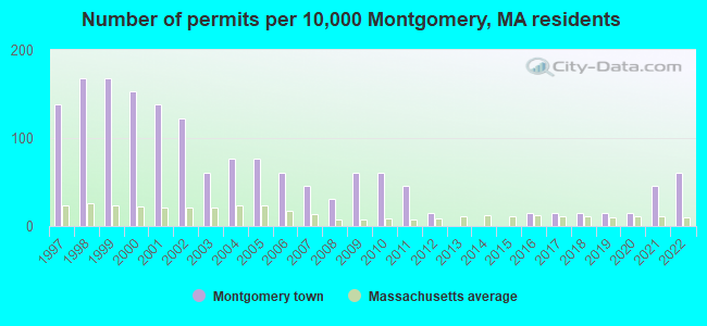
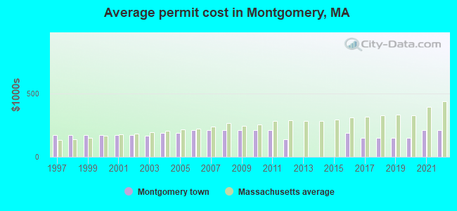
Single-family new house construction building permits:
- 2022: 4 buildings, average cost: $211,700
- 2021: 3 buildings, average cost: $211,700
- 2020: 1 building, cost: $150,000
- 2019: 1 building, cost: $150,000
- 2018: 1 building, cost: $150,000
- 2017: 1 building, cost: $150,000
- 2016: 1 building, cost: $189,000
- 2012: 1 building, cost: $140,000
- 2011: 3 buildings, average cost: $211,000
- 2010: 4 buildings, average cost: $211,000
- 2009: 4 buildings, average cost: $211,000
- 2008: 2 buildings, average cost: $211,000
- 2007: 3 buildings, average cost: $211,000
- 2006: 4 buildings, average cost: $211,000
- 2005: 5 buildings, average cost: $185,900
- 2004: 5 buildings, average cost: $185,900
- 2003: 4 buildings, average cost: $165,800
- 2002: 8 buildings, average cost: $168,800
- 2001: 9 buildings, average cost: $168,800
- 2000: 10 buildings, average cost: $168,800
- 1999: 11 buildings, average cost: $168,800
- 1998: 11 buildings, average cost: $168,800
- 1997: 9 buildings, average cost: $168,800
| Here: | 3.5% |
| Massachusetts: | 3.5% |
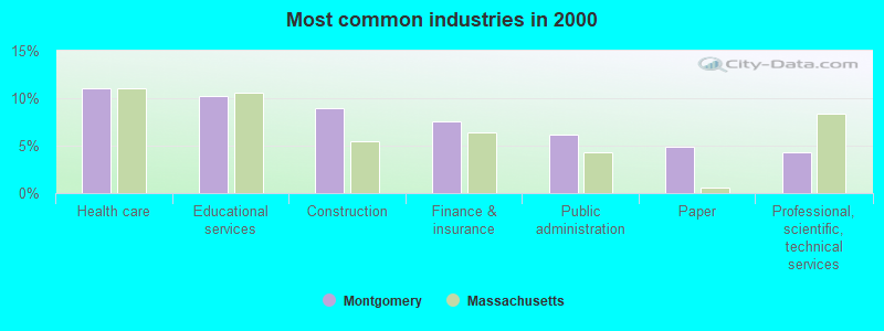
- Health care (11.1%)
- Educational services (10.3%)
- Construction (8.9%)
- Finance & insurance (7.6%)
- Public administration (6.2%)
- Paper (4.9%)
- Professional, scientific, technical services (4.3%)
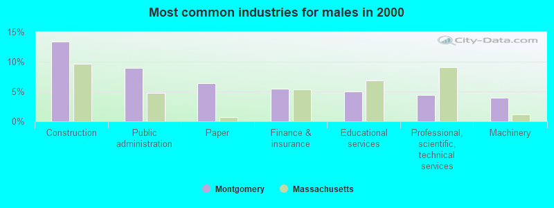
- Construction (13.4%)
- Public administration (8.9%)
- Paper (6.4%)
- Finance & insurance (5.4%)
- Educational services (5.0%)
- Professional, scientific, technical services (4.5%)
- Machinery (4.0%)
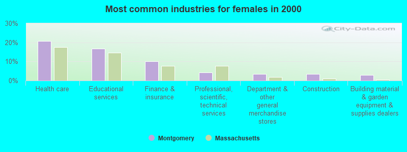
- Health care (20.8%)
- Educational services (16.7%)
- Finance & insurance (10.1%)
- Professional, scientific, technical services (4.2%)
- Department & other general merchandise stores (3.6%)
- Construction (3.6%)
- Building material & garden equipment & supplies dealers (3.0%)

- Other sales and related occupations, including supervisors (5.7%)
- Other production occupations, including supervisors (4.6%)
- Preschool, kindergarten, elementary, and middle school teachers (4.3%)
- Other management occupations, except farmers and farm managers (3.8%)
- Registered nurses (3.8%)
- Electrical equipment mechanics and other installation, maintenance, and repair workers, including supervisors (3.5%)
- Driver/sales workers and truck drivers (3.2%)
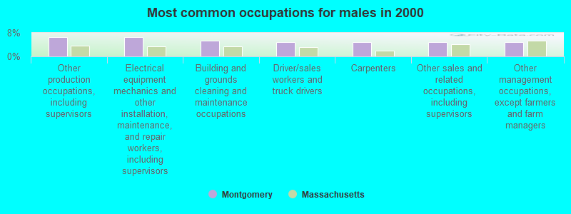
- Other production occupations, including supervisors (6.4%)
- Electrical equipment mechanics and other installation, maintenance, and repair workers, including supervisors (6.4%)
- Building and grounds cleaning and maintenance occupations (5.4%)
- Driver/sales workers and truck drivers (5.0%)
- Carpenters (5.0%)
- Other sales and related occupations, including supervisors (5.0%)
- Other management occupations, except farmers and farm managers (5.0%)
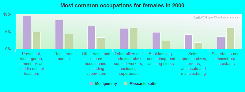
- Preschool, kindergarten, elementary, and middle school teachers (9.5%)
- Registered nurses (8.3%)
- Other sales and related occupations, including supervisors (6.5%)
- Other office and administrative support workers, including supervisors (6.0%)
- Bookkeeping, accounting, and auditing clerks (4.8%)
- Sales representatives, services, wholesale and manufacturing (4.2%)
- Secretaries and administrative assistants (3.6%)
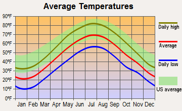
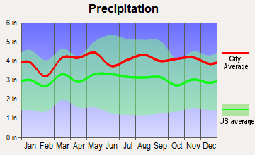
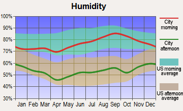
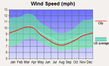
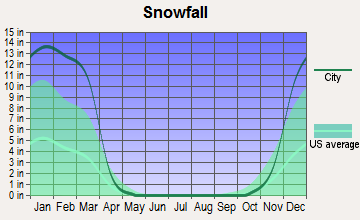
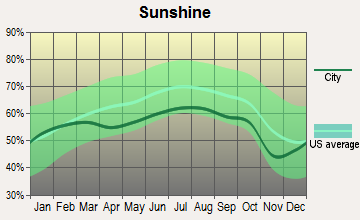
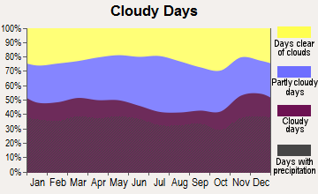
Average climate in Montgomery, Massachusetts
Based on data reported by over 4,000 weather stations
(lower is better)
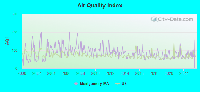
Air Quality Index (AQI) level in 2022 was 68.4. This is about average.
| City: | 68.4 |
| U.S.: | 72.6 |
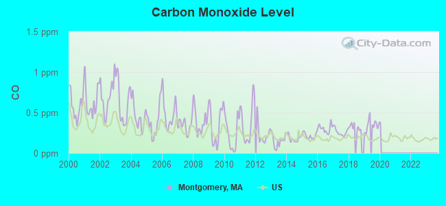
Carbon Monoxide (CO) [ppm] level in 2019 was 0.346. This is worse than average. Closest monitor was 11.1 miles away from the city center.
| City: | 0.346 |
| U.S.: | 0.251 |
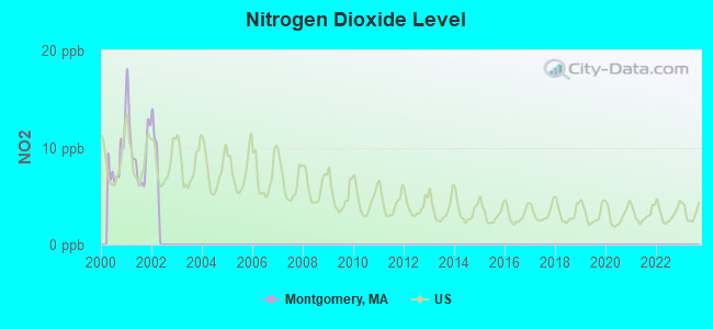
Nitrogen Dioxide (NO2) [ppb] level in 2001 was 9.83. This is significantly worse than average. Closest monitor was 11.1 miles away from the city center.
| City: | 9.83 |
| U.S.: | 5.11 |
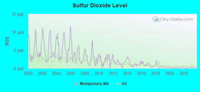
Sulfur Dioxide (SO2) [ppb] level in 2022 was 0.141. This is significantly better than average. Closest monitor was 9.9 miles away from the city center.
| City: | 0.141 |
| U.S.: | 1.515 |
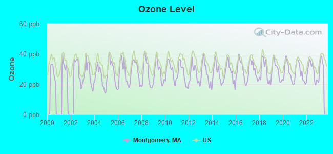
Ozone [ppb] level in 2022 was 28.5. This is about average. Closest monitor was 10.8 miles away from the city center.
| City: | 28.5 |
| U.S.: | 33.3 |
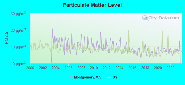
Particulate Matter (PM2.5) [µg/m3] level in 2022 was 6.88. This is about average. Closest monitor was 13.5 miles away from the city center.
| City: | 6.88 |
| U.S.: | 8.11 |
Tornado activity:
Montgomery-area historical tornado activity is above Massachusetts state average. It is 9% smaller than the overall U.S. average.
On 10/3/1979, a category F4 (max. wind speeds 207-260 mph) tornado 12.7 miles away from the Montgomery town center killed 3 people and injured 500 people and caused between $50,000,000 and $500,000,000 in damages.
On 5/29/1995, a category F4 tornado 18.3 miles away from the town center killed 3 people and injured 24 people and caused between $5,000,000 and $50,000,000 in damages.
Earthquake activity:
Montgomery-area historical earthquake activity is significantly above Massachusetts state average. It is 70% smaller than the overall U.S. average.On 10/7/1983 at 10:18:46, a magnitude 5.3 (5.1 MB, 5.3 LG, 5.1 ML, Class: Moderate, Intensity: VI - VII) earthquake occurred 142.9 miles away from the city center
On 4/20/2002 at 10:50:47, a magnitude 5.3 (5.3 ML, Depth: 3.0 mi) earthquake occurred 165.1 miles away from the city center
On 4/20/2002 at 10:50:47, a magnitude 5.2 (5.2 MB, 4.2 MS, 5.2 MW, 5.0 MW) earthquake occurred 163.7 miles away from Montgomery center
On 1/19/1982 at 00:14:42, a magnitude 4.7 (4.5 MB, 4.7 MD, 4.5 LG, Class: Light, Intensity: IV - V) earthquake occurred 108.4 miles away from the city center
On 10/16/2012 at 23:12:25, a magnitude 4.7 (4.7 ML, Depth: 10.0 mi) earthquake occurred 145.5 miles away from Montgomery center
On 8/23/2011 at 17:51:04, a magnitude 5.8 (5.8 MW, Depth: 3.7 mi) earthquake occurred 402.3 miles away from Montgomery center
Magnitude types: regional Lg-wave magnitude (LG), body-wave magnitude (MB), duration magnitude (MD), local magnitude (ML), surface-wave magnitude (MS), moment magnitude (MW)
Natural disasters:
The number of natural disasters in Hampden County (22) is greater than the US average (15).Major Disasters (Presidential) Declared: 12
Emergencies Declared: 9
Causes of natural disasters: Storms: 6, Floods: 5, Hurricanes: 5, Snowstorms: 4, Winter Storms: 4, Blizzards: 2, Snows: 2, Snowfall: 1, Tornado: 1, Tropical Storm: 1, Wind: 1, Other: 1 (Note: some incidents may be assigned to more than one category).
Hospitals and medical centers in Montgomery:
Other hospitals and medical centers near Montgomery:
- NOBLE HOSPITAL Acute Care Hospitals (about 8 miles away; WESTFIELD, MA)
- NOBLE VISITING NURSE (Home Health Center, about 8 miles away; WESTFIELD, MA)
- GOVERNORS CENTER (Nursing Home, about 8 miles away; WESTFIELD, MA)
- WESTFIELD CARE AND REHABILITATION CENTER (Nursing Home, about 8 miles away; WESTFIELD, MA)
- LOOMIS HOUSE NURSING CENTER (Nursing Home, about 9 miles away; HOLYOKE, MA)
- HOLYOKE REHABILITATION CENTER (Nursing Home, about 10 miles away; HOLYOKE, MA)
- WESTERN MASSACHUSETTS HOSPITAL (Hospital, about 10 miles away; WESTFIELD, MA)
Amtrak stations near Montgomery:
- 14 miles: SPRINGFIELD (66 LYMAN ST.) . Services: ticket office, partially wheelchair accessible, enclosed waiting area, public restrooms, public payphones, full-service food facilities, snack bar, vending machines, ATM, paid short-term parking, paid long-term parking, call for car rental service, taxi stand, intercity bus service, public transit connection.
- 20 miles: AMHERST (RAILROAD ST.) . Services: enclosed waiting area, public payphones, free short-term parking, paid long-term parking, call for car rental service, call for taxi service, public transit connection.
Colleges/universities with over 2000 students nearest to Montgomery:
- Westfield State University (about 6 miles; Westfield, MA; Full-time enrollment: 5,548)
- Holyoke Community College (about 9 miles; Holyoke, MA; FT enrollment: 4,911)
- Smith College (about 12 miles; Northampton, MA; FT enrollment: 3,549)
- Mount Holyoke College (about 13 miles; South Hadley, MA; FT enrollment: 2,573)
- Springfield Technical Community College (about 15 miles; Springfield, MA; FT enrollment: 4,750)
- American International College (about 15 miles; Springfield, MA; FT enrollment: 2,733)
- Springfield College (about 16 miles; Springfield, MA; FT enrollment: 3,144)
Points of interest:
Notable location: Montgomery Fire Department (A). Display/hide its location on the map
Church in Montgomery: Montgomery Church (A). Display/hide its location on the map
Cemeteries: Montgomery Center Cemetery (1), Clarks Cemetery (2). Display/hide their locations on the map
Lakes and reservoirs: Shatterack Pond (A), Moose Meadow Brook Reservoir (B), Westfield River Reservoir (C), Tekoa Reservoir (D), Westfield Reservoir (E). Display/hide their locations on the map
Streams, rivers, and creeks: Crow Brook (A), Roaring Brook (B), Bearden Brook (C). Display/hide their locations on the map
| This town: | 2.5 people |
| Massachusetts: | 2.5 people |
| This town: | 74.5% |
| Whole state: | 63.0% |
| This town: | 4.5% |
| Whole state: | 7.0% |
Likely homosexual households (counted as self-reported same-sex unmarried-partner households)
- Lesbian couples: 0.0% of all households
- Gay men: 0.3% of all households
| This town: | 2.9% |
| Whole state: | 9.3% |
| This town: | 2.0% |
| Whole state: | 4.4% |
For population 15 years and over in Montgomery:
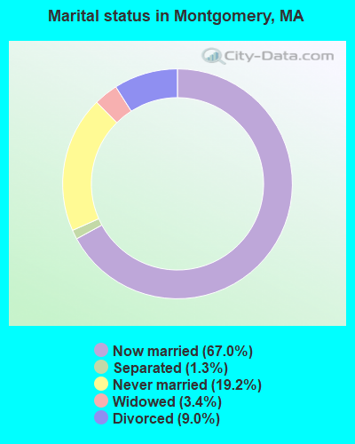
- Never married: 19.2%
- Now married: 67.0%
- Separated: 1.3%
- Widowed: 3.4%
- Divorced: 9.0%
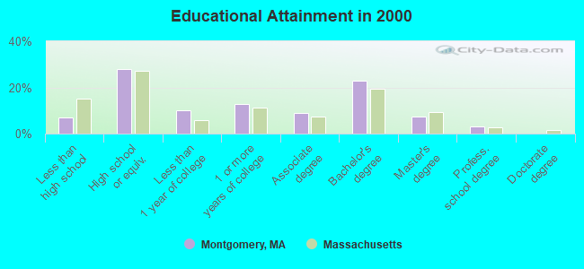
For population 25 years and over in Montgomery:
- High school or higher: 93.0%
- Bachelor's degree or higher: 33.6%
- Graduate or professional degree: 10.5%
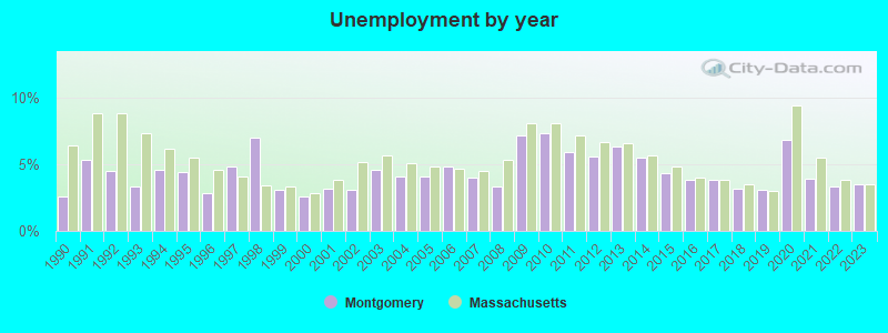
- Unemployed: 2.1%
- Mean travel time to work (commute): 29.7 minutes
| Here: | 9.9 |
| Massachusetts average: | 13.1 |
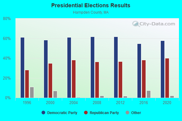
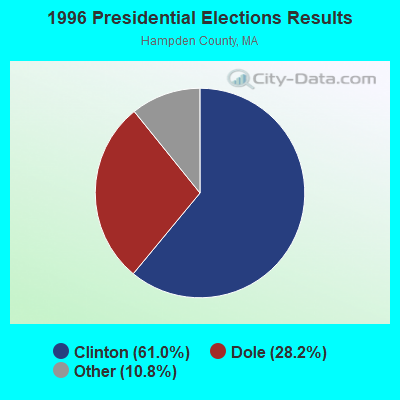
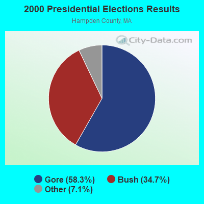
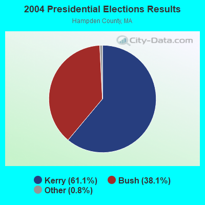
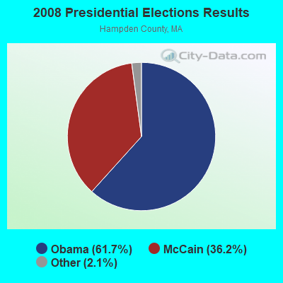
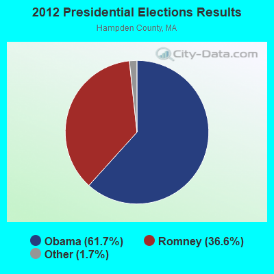
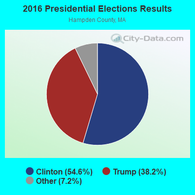
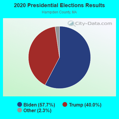
Graphs represent county-level data. Detailed 2008 Election Results
Religion statistics for Montgomery, MA (based on Hampden County data)
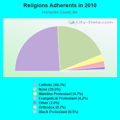
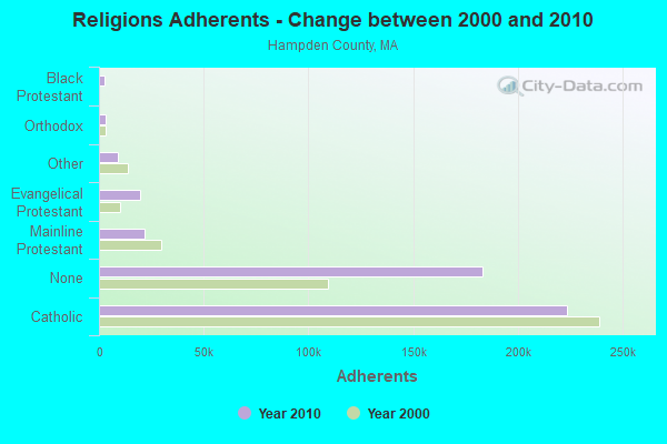
| Religion | Adherents | Congregations |
|---|---|---|
| Catholic | 223,685 | 65 |
| Mainline Protestant | 21,962 | 88 |
| Evangelical Protestant | 19,438 | 114 |
| Other | 9,140 | 31 |
| Orthodox | 3,406 | 10 |
| Black Protestant | 2,491 | 16 |
| None | 183,368 | - |
Food Environment Statistics:
| Hampden County: | 1.95 / 10,000 pop. |
| State: | 1.98 / 10,000 pop. |
| Hampden County: | 0.04 / 10,000 pop. |
| Massachusetts: | 0.05 / 10,000 pop. |
| Hampden County: | 1.87 / 10,000 pop. |
| Massachusetts: | 2.22 / 10,000 pop. |
| Here: | 2.43 / 10,000 pop. |
| Massachusetts: | 1.77 / 10,000 pop. |
| This county: | 7.27 / 10,000 pop. |
| Massachusetts: | 8.76 / 10,000 pop. |
| This county: | 9.2% |
| State: | 8.1% |
| Hampden County: | 25.9% |
| Massachusetts: | 22.5% |
| Hampden County: | 16.2% |
| Massachusetts: | 16.5% |
3.64% of this county's 2021 resident taxpayers lived in other counties in 2020 ($58,474 average adjusted gross income)
| Here: | 3.64% |
| Massachusetts average: | 6.35% |
0.02% of residents moved from foreign countries ($105 average AGI)
Hampden County: 0.02% Massachusetts average: 0.01%
Top counties from which taxpayers relocated into this county between 2020 and 2021:
| from Hampshire County, MA | |
| from Hartford County, CT | |
| from Worcester County, MA |
4.26% of this county's 2020 resident taxpayers moved to other counties in 2021 ($66,146 average adjusted gross income)
| Here: | 4.26% |
| Massachusetts average: | 7.18% |
0.03% of residents moved to foreign countries ($223 average AGI)
Hampden County: 0.03% Massachusetts average: 0.02%
Top counties to which taxpayers relocated from this county between 2020 and 2021:
| to Hampshire County, MA | |
| to Hartford County, CT | |
| to Worcester County, MA |
Strongest AM radio stations in Montgomery:
- WNNZ (640 AM; 50 kW; WESTFIELD, MA; Owner: CLEAR CHANNEL BROADCASTING LICENSES, INC.)
- WHYN (560 AM; 5 kW; SPRINGFIELD, MA; Owner: CLEAR CHANNEL BROADCASTING LICENSES, INC.)
- WACE (730 AM; 5 kW; CHICOPEE, MA; Owner: CARTER BROADCASTING CORP.)
- WTIC (1080 AM; 50 kW; HARTFORD, CT; Owner: INFINITY RADIO OPERATIONS INC.)
- WCRN (830 AM; 50 kW; WORCESTER, MA; Owner: CARTER BROADCASTING CORPORATION)
- WSPR (1270 AM; 5 kW; SPRINGFIELD, MA; Owner: ANTONIO F. AND HELENA R. GOIS, TENANTS BY THE ENTIRETY)
- WVNE (760 AM; daytime; 25 kW; LEICESTER, MA; Owner: BLOUNT MASSCOM, INC.)
- WALE (990 AM; 50 kW; GREENVILLE, RI; Owner: NORTH AMERICAN BROADCASTING CO., INC.)
- WGY (810 AM; 50 kW; SCHENECTADY, NY; Owner: CLEAR CHANNEL BROADCASTING LICENSES, INC.)
- WRKO (680 AM; 50 kW; BOSTON, MA; Owner: ENTERCOM BOSTON LICENSE, LLC)
- WPNI (1430 AM; 5 kW; AMHERST, MA; Owner: WESTERN MASSACHUSETTS RADIO COMPANY)
- WEEI (850 AM; 50 kW; BOSTON, MA; Owner: ENTERCOM BOSTON LICENSE, LLC)
- WKOX (1200 AM; 50 kW; FRAMINGHAM, MA; Owner: CAPSTAR TX LIMITED PARTNERSHIP)
Strongest FM radio stations in Montgomery:
- WHYN-FM (93.1 FM; SPRINGFIELD, MA; Owner: CLEAR CHANNEL BROADCASTING LICENSES, INC.)
- WRNX (100.9 FM; AMHERST, MA; Owner: WESTERN MASSACHUSETTS RADIO COMPANY)
- WAQY (102.1 FM; SPRINGFIELD, MA; Owner: SAGA COMMUNICATIONS OF NEW ENGLAND, LLC)
- WPKX (97.9 FM; ENFIELD, CT; Owner: CAPSTAR TX LIMITED PARTNERSHIP)
- WAMC-FM (90.3 FM; ALBANY, NY; Owner: WAMC)
- WFCR (88.5 FM; AMHERST, MA; Owner: UNIVERSITY OF MASSACHUSETTS)
- WCCH (103.5 FM; HOLYOKE, MA; Owner: HOLYOKE COMMUNITY COLLEGE)
- WLZX (99.3 FM; NORTHAMPTON, MA; Owner: SAGA COMMUNICATIONS OF NEW ENGLAND, LLC)
- WAMH (89.3 FM; AMHERST, MA; Owner: TRUSTEES OF AMHERST COLLEGE)
- WRCH (100.5 FM; NEW BRITAIN, CT; Owner: INFINITY RADIO OPERATIONS INC.)
- W246AM (97.1 FM; AMHERST, MA; Owner: GREAT NORTHERN RADIO, LLC)
- WEIB (106.3 FM; NORTHAMPTON, MA; Owner: CUTTING EDGE BROADCASTING, INC.)
- WHVP (91.1 FM; HUDSON, NY; Owner: SOUND OF LIFE, INC.)
- WEQX (102.7 FM; MANCHESTER, VT; Owner: NORTHSHIRE COMMUNICATIONS, INC.)
- WJAN (95.1 FM; SUNDERLAND, VT; Owner: 6 JOHNSON ROAD LICENSES, INC.)
- WTIC-FM (96.5 FM; HARTFORD, CT; Owner: INFINITY RADIO OPERATIONS INC.)
- WAMQ (105.1 FM; GREAT BARRINGTON, MA; Owner: WAMC)
- WWUH (91.3 FM; WEST HARTFORD, CT; Owner: UNIVERSITY OF HARTFORD)
- WCCC-FM (106.9 FM; HARTFORD, CT; Owner: MARLIN BROADCASTING, LLC)
- WVAY (100.7 FM; WILMINGTON, VT; Owner: GREAT NORTHERN RADIO, L.L.C.)
TV broadcast stations around Montgomery:
- WWLP (Channel 22; SPRINGFIELD, MA; Owner: WWLP BROADCASTING, LLC)
- W67DF (Channel 67; SPRINGFIELD, MA; Owner: TRINITY BROADCASTING NETWORK)
- WTIC-TV (Channel 61; HARTFORD, CT; Owner: TRIBUNE TELEVISION COMPANY)
- W11BJ (Channel 11; HARTFORD, CT; Owner: COMMUNICATIONS SITE MANAGEMENT LLC)
- WYDN (Channel 48; WORCESTER, MA; Owner: EDUCATIONAL PUBLIC TV CORPORATION)
- WUVN (Channel 18; HARTFORD, CT; Owner: ENTRAVISION HOLDINGS, LLC)
- WTXX (Channel 20; WATERBURY, CT; Owner: WTXX INC.)
- WVIT (Channel 30; NEW BRITAIN, CT; Owner: OUTLET BROADCASTING, INC)
- WGGB-TV (Channel 40; SPRINGFIELD, MA; Owner: WGGB LICENSEE, LLC)
- WGBY-TV (Channel 57; SPRINGFIELD, MA; Owner: WGBH EDUCATIONAL FOUNDATION)
- WEDH (Channel 24; HARTFORD, CT; Owner: CONNECTICUT PUBLIC BROADCASTING, INC.)
- WDMR-LP (Channel 65; SPRINGFIELD, MA; Owner: ZGS HARTFORD, INC.)
- WFSB (Channel 3; HARTFORD, CT; Owner: MEREDITH CORPORATION)
- W12CL (Channel 12; GRANBY, CT; Owner: SALVATORE MINNITI)
Montgomery fatal accident list:
Jun 4, 1999 07:50 PM, Main Rd, Vehicles: 2, Persons: 2, Fatalities: 1
Nov 10, 1994 11:55 PM, Main Rd, Vehicles: 1, Persons: 3, Fatalities: 1
Aug 31, 1986 02:55 PM, Main Road, Vehicles: 1, Persons: 1, Fatalities: 1
Aug 31, 1982 07:05 AM, Vehicles: 2, Persons: 2, Fatalities: 1
Jan 27, 1976 04:50 PM, Vehicles: 1, Persons: 2, Fatalities: 1
Jan 27, 1975 04:50 PM, Vehicles: 1, Persons: 2, Fatalities: 1
- National Bridge Inventory (NBI) Statistics
- 6Number of bridges
- 167ft / 51.4mTotal length
- $67,239,000Total costs
- 35,738Total average daily traffic
- 3,850Total average daily truck traffic
FCC Registered Antenna Towers:
2- William C Charamut, Parcel A, Pitcher St. (Lat: 42.180361 Lon: -72.800639), Type: 32.0, Overall height: 22.8 m, Registrant: Connecticut Radio Repeaters, LLC., Syracuse282aol.Com, , 487 Rocky- Hill, Phone: (860) 563-4867
- WILLIAM C CHARAMUT, Parcel A, Pitcher St. (Lat: 42.180361 Lon: -72.800639), Type: 32.0, Overall height: 22.8 m, Registrant: Connecticut Radio Repeaters, LLC., Syracuse282aol.Com, , 487 Rocky- Hill, Phone: (860) 563-4867
FCC Registered Broadcast Land Mobile Towers:
2- Pine Ridge Rd (Lat: 42.212028 Lon: -72.807306), Structure height: 37 m, Call Sign: KLH898, Licensee ID: L00072829,
Assigned Frequencies: 159.180 MHz, Grant Date: 02/05/2005, Expiration Date: 03/14/2015, Cancellation Date: 08/09/2013, Registrant: Massdot, Highway Division, 668 South Ave, Weston, MA 02493, Phone: (781) 431-5166, Fax: (781) 431-5169, Email:
- Shatterack Mountain Off Russell Rd (Lat: 42.199250 Lon: -72.835083), Call Sign: KCA335,
Assigned Frequencies: 42.4400 MHz, 42.4600 MHz, 44.7400 MHz, Grant Date: 04/06/2022, Expiration Date: 05/19/2032, Registrant: Massachusetts, Commonwealth Of Department Of State Police, 470 Worcester Rd, Framingham, MA 01702, Phone: (508) 820-2222, Email:
FCC Registered Microwave Towers:
1- STATION, Shatterack Mountain Off Russell Rd (Lat: 42.199250 Lon: -72.835083), Overall height: 51.8 m, Call Sign: WEE325,
Assigned Frequencies: 954.900 MHz, Grant Date: 10/30/2018, Expiration Date: 12/23/2028, Registrant: Massachusetts State Police, 470 Worchester Rd, Framingham, MA 01701, Phone: (508) 820-2222, Email:
FCC Registered Amateur Radio Licenses:
4- Call Sign: N1EFQ, Licensee ID: L01297673, Grant Date: 06/23/2007, Expiration Date: 06/23/2017, Cancellation Date: 06/25/2019, Registrant: John E Grabowski, 1631 Russell Rd, Montgomery, MA 01085
- Call Sign: N1EIP, Licensee ID: L01027087, Grant Date: 03/01/2017, Expiration Date: 03/30/2027, Certifier: A Richard Chretien, Registrant: A Richard Chretien, 87 Main Road, Montgomery, MA 01085
- Call Sign: N1SRF, Licensee ID: L00853616, Grant Date: 04/26/2004, Expiration Date: 07/15/2014, Cancellation Date: 07/16/2016, Certifier: David F Mc Clellan Sr, Registrant: David F Mc Clellan Sr, 196 Pitcher St, Montgomery, MA 01085
- Call Sign: KB1JVF, Licensee ID: L00672441, Grant Date: 04/17/2003, Expiration Date: 04/17/2013, Cancellation Date: 04/18/2015, Certifier: James L Harrington Jr, Registrant: James L Harrington Jr, 80 Upper Pomeroy Rd, Montgomery, MA 01085
FAA Registered Aircraft:
1- Aircraft: AVIAT AIRCRAFT INC A-1B (Category: Land, Seats: 2, Weight: Up to 12,499 Pounds), Engine: LYCOMING O-360 SERIES (180 HP) (Reciprocating)
N-Number: 56HY, N56HY, N-56HY, Serial Number: 2222, Year manufactured: 2003, Airworthiness Date: 02/21/2003, Certificate Issue Date: 09/15/2016
Registrant (Individual): Robert J Cipolli, 201 Pitcher St, Montgomery, MA 01085
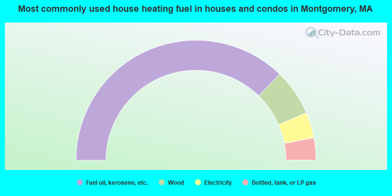
- 74.6%Fuel oil, kerosene, etc.
- 12.5%Wood
- 6.9%Electricity
- 6.0%Bottled, tank, or LP gas
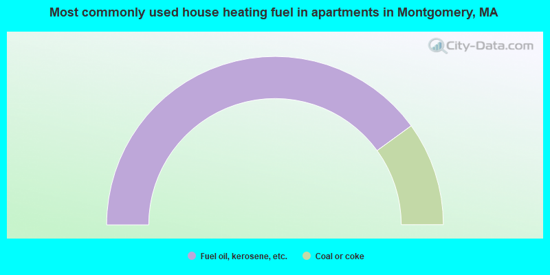
- 80.0%Fuel oil, kerosene, etc.
- 20.0%Coal or coke
Montgomery compared to Massachusetts state average:
- Unemployed percentage significantly below state average.
- Black race population percentage significantly below state average.
- Hispanic race population percentage significantly below state average.
- Median age above state average.
- Foreign-born population percentage significantly below state average.
- Renting percentage significantly below state average.
- Length of stay since moving in significantly above state average.
- Number of rooms per house significantly below state average.
- House age significantly below state average.

|
Total of 1 patent application in 2008-2024.