Monson, Maine

Submit your own pictures of this town and show them to the world
- OSM Map
- General Map
- Google Map
- MSN Map
Population change since 2000: +3.0%
 |
| Males: 363 | |
| Females: 323 |
| Median resident age: | 50.4 years |
| Maine median age: | 43.0 years |
Zip codes: 04464.
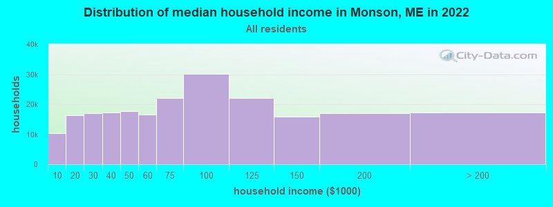
| Monson: | $50,383 |
| ME: | $69,543 |
Estimated per capita income in 2022: $33,277 (it was $14,044 in 2000)
Monson town income, earnings, and wages data
Estimated median house or condo value in 2022: $159,680 (it was $61,400 in 2000)
| Monson: | $159,680 |
| ME: | $290,600 |
Mean prices in 2022: all housing units: $203,844; detached houses: $217,964; townhouses or other attached units: $250,113; in 2-unit structures: $253,343; in 3-to-4-unit structures: $283,591; in 5-or-more-unit structures: $146,783; mobile homes: $82,683
Detailed information about poverty and poor residents in Monson, ME


- 65695.6%White alone
- 142.0%Two or more races
- 81.2%Hispanic
- 40.6%American Indian alone
- 20.3%Black alone
- 10.1%Asian alone
- 10.1%Other race alone
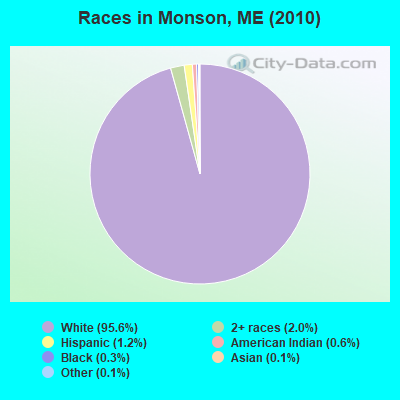
Races in Monson detailed stats: ancestries, foreign born residents, place of birth
 Recent articles from our blog. Our writers, many of them Ph.D. graduates or candidates, create easy-to-read articles on a wide variety of topics.

 | "The 18 Essential Maine Restaurants" (13 replies) |
| Starting to really think relocating to new england (26 replies) |
| Maine Population Shifts (44 replies) |
| Is Quiet and remote possible within 45 minutes of Greenville? (7 replies) |
| Maine weather thread (3207 replies) |
| Opinions on SeDoMoCha Schools (0 replies) |
Latest news from Monson, ME collected exclusively by city-data.com from local newspapers, TV, and radio stations
Ancestries: English (20.4%), French (14.6%), Irish (12.9%), Scottish (10.4%), United States (9.6%), German (7.1%).
Current Local Time: EST time zone
Incorporated on 02/08/1822
Elevation: 850 feet
Land area: 47.1 square miles.
Population density: 15 people per square mile (very low).
5 residents are foreign born
| This town: | 0.8% |
| Maine: | 2.9% |
| Monson town: | 1.2% ($719) |
| Maine: | 1.5% ($1,417) |
Nearest city with pop. 50,000+: Portland, ME  (118.3 miles , pop. 64,249).
Nearest city with pop. 200,000+: Boston, MA (219.8 miles , pop. 589,141).
Nearest city with pop. 1,000,000+: Bronx, NY (378.0 miles , pop. 1,332,650).
Nearest cities:
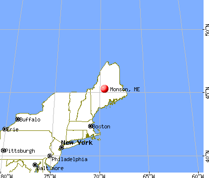
), Latitude: 45.29 N, Longitude: 69.51 W
Area code: 207

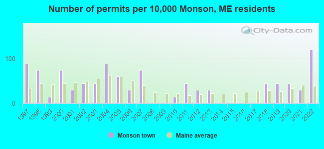
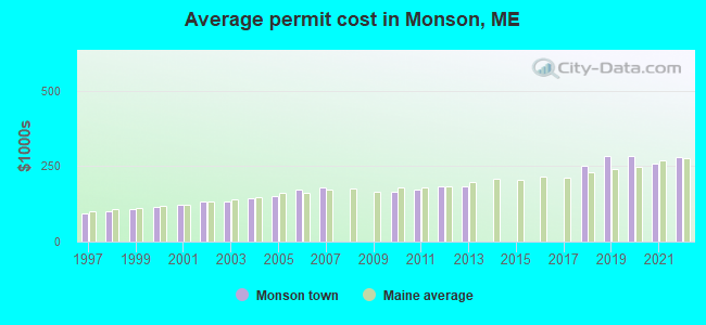
Single-family new house construction building permits:
- 2022: 8 buildings, average cost: $279,200
- 2021: 2 buildings, average cost: $259,200
- 2020: 3 buildings, average cost: $282,200
- 2019: 3 buildings, average cost: $282,200
- 2018: 3 buildings, average cost: $249,800
- 2013: 2 buildings, average cost: $184,000
- 2012: 2 buildings, average cost: $184,000
- 2011: 3 buildings, average cost: $172,800
- 2010: 1 building, cost: $165,900
- 2007: 5 buildings, average cost: $181,200
- 2006: 2 buildings, average cost: $171,000
- 2005: 4 buildings, average cost: $150,200
- 2004: 6 buildings, average cost: $141,800
- 2003: 3 buildings, average cost: $132,800
- 2002: 3 buildings, average cost: $130,700
- 2001: 2 buildings, average cost: $121,400
- 2000: 5 buildings, average cost: $114,400
- 1999: 1 building, cost: $109,200
- 1998: 5 buildings, average cost: $101,700
- 1997: 6 buildings, average cost: $91,700
| Here: | 3.6% |
| Maine: | 3.4% |
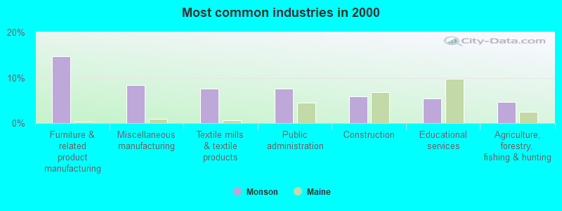
- Furniture & related product manufacturing (14.8%)
- Miscellaneous manufacturing (8.4%)
- Textile mills & textile products (7.6%)
- Public administration (7.6%)
- Construction (5.9%)
- Educational services (5.5%)
- Agriculture, forestry, fishing & hunting (4.6%)
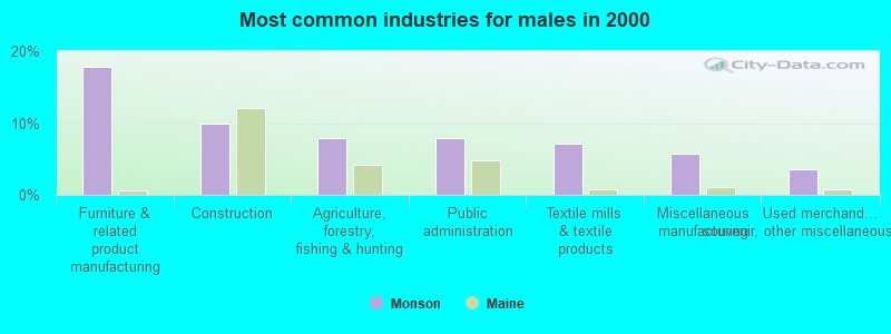
- Furniture & related product manufacturing (17.9%)
- Construction (10.0%)
- Agriculture, forestry, fishing & hunting (7.9%)
- Public administration (7.9%)
- Textile mills & textile products (7.1%)
- Miscellaneous manufacturing (5.7%)
- Used merchandise, gift, novelty, souvenir, other miscellaneous stores (3.6%)
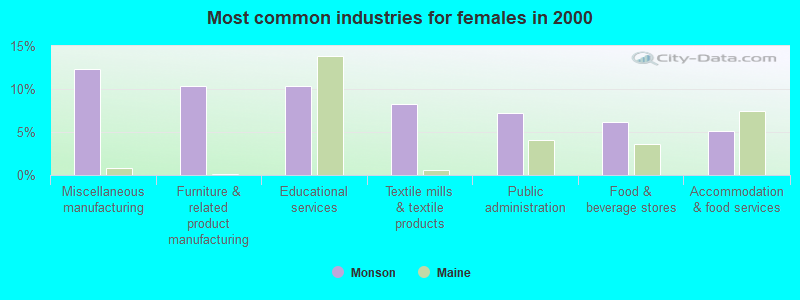
- Miscellaneous manufacturing (12.4%)
- Furniture & related product manufacturing (10.3%)
- Educational services (10.3%)
- Textile mills & textile products (8.2%)
- Public administration (7.2%)
- Food & beverage stores (6.2%)
- Accommodation & food services (5.2%)
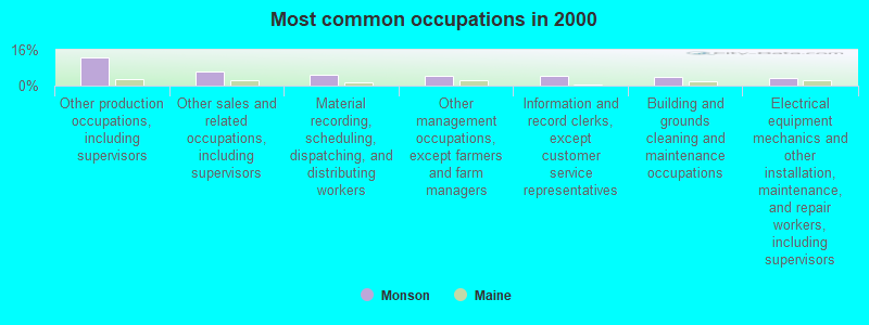
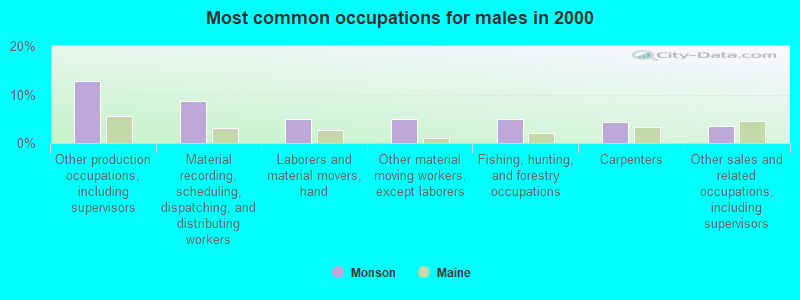
- Other production occupations, including supervisors (12.7%)
- Other sales and related occupations, including supervisors (6.3%)
- Material recording, scheduling, dispatching, and distributing workers (5.1%)
- Other management occupations, except farmers and farm managers (4.2%)
- Information and record clerks, except customer service representatives (4.2%)
- Building and grounds cleaning and maintenance occupations (3.8%)
- Electrical equipment mechanics and other installation, maintenance, and repair workers, including supervisors (3.4%)
- Other production occupations, including supervisors (12.9%)
- Material recording, scheduling, dispatching, and distributing workers (8.6%)
- Laborers and material movers, hand (5.0%)
- Other material moving workers, except laborers (5.0%)
- Fishing, hunting, and forestry occupations (5.0%)
- Carpenters (4.3%)
- Other sales and related occupations, including supervisors (3.6%)
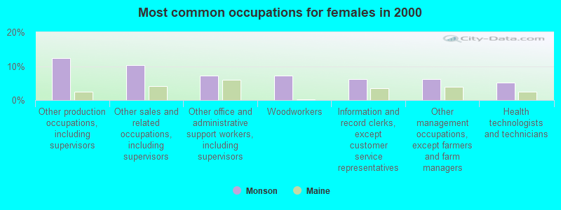
- Other production occupations, including supervisors (12.4%)
- Other sales and related occupations, including supervisors (10.3%)
- Other office and administrative support workers, including supervisors (7.2%)
- Woodworkers (7.2%)
- Information and record clerks, except customer service representatives (6.2%)
- Other management occupations, except farmers and farm managers (6.2%)
- Health technologists and technicians (5.2%)
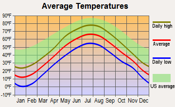
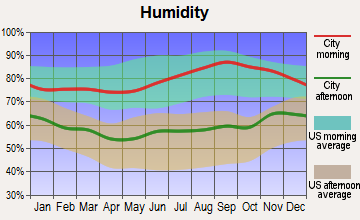
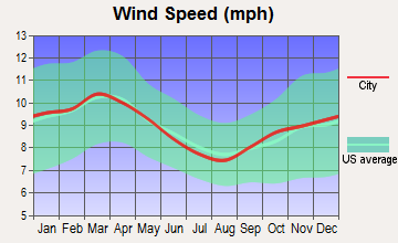
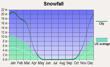
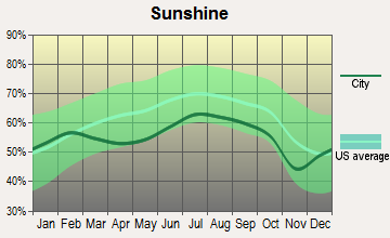
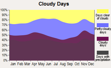
Average climate in Monson, Maine
Based on data reported by over 4,000 weather stations
(lower is better)
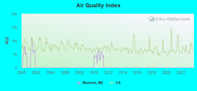
Air Quality Index (AQI) level in 2010 was 43.8. This is significantly better than average.
| City: | 43.8 |
| U.S.: | 72.6 |
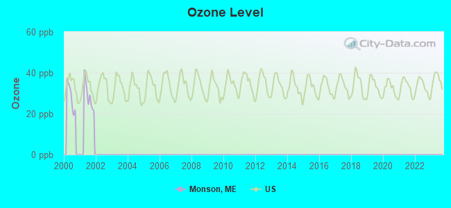
Ozone [ppb] level in 2001 was 28.8. This is about average. Closest monitor was 12.6 miles away from the city center.
| City: | 28.8 |
| U.S.: | 33.3 |
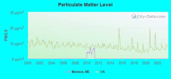
Particulate Matter (PM2.5) [µg/m3] level in 2010 was 4.31. This is significantly better than average. Closest monitor was 13.0 miles away from the city center.
| City: | 4.31 |
| U.S.: | 8.11 |
Earthquake activity:
Monson-area historical earthquake activity is significantly above Maine state average. It is 81% smaller than the overall U.S. average.On 4/20/2002 at 10:50:47, a magnitude 5.3 (5.3 ML, Depth: 3.0 mi, Class: Moderate, Intensity: VI - VII) earthquake occurred 212.2 miles away from the city center
On 4/20/2002 at 10:50:47, a magnitude 5.2 (5.2 MB, 4.2 MS, 5.2 MW, 5.0 MW) earthquake occurred 213.7 miles away from Monson center
On 10/16/2012 at 23:12:25, a magnitude 4.7 (4.7 ML, Depth: 10.0 mi, Class: Light, Intensity: IV - V) earthquake occurred 129.9 miles away from Monson center
On 10/7/1983 at 10:18:46, a magnitude 5.3 (5.1 MB, 5.3 LG, 5.1 ML) earthquake occurred 255.3 miles away from Monson center
On 1/19/1982 at 00:14:42, a magnitude 4.7 (4.5 MB, 4.7 MD, 4.5 LG) earthquake occurred 161.2 miles away from Monson center
On 2/26/1999 at 03:38:43, a magnitude 3.8 (3.8 LG, Depth: 2.0 mi, Class: Light, Intensity: II - III) earthquake occurred 55.8 miles away from the city center
Magnitude types: regional Lg-wave magnitude (LG), body-wave magnitude (MB), duration magnitude (MD), local magnitude (ML), surface-wave magnitude (MS), moment magnitude (MW)
Natural disasters:
The number of natural disasters in Piscataquis County (22) is greater than the US average (15).Major Disasters (Presidential) Declared: 15
Emergencies Declared: 6
Causes of natural disasters: Floods: 13, Storms: 12, Snows: 7, Heavy Rains: 2, Blizzard: 1, Ice Storm: 1, Landslide: 1, Snowfall: 1, Wind: 1, Winter Storm: 1, Other: 2 (Note: some incidents may be assigned to more than one category).

Colleges/universities with over 2000 students nearest to Monson:
- Husson University (about 48 miles; Bangor, ME; Full-time enrollment: 2,421)
- University of Maine (about 49 miles; Orono, ME; FT enrollment: 8,931)
- University of Maine at Farmington (about 54 miles; Farmington, ME; FT enrollment: 2,036)
- University of Maine at Augusta (about 68 miles; Augusta, ME; FT enrollment: 3,204)
- Saint Joseph's College of Maine (about 112 miles; Standish, ME; FT enrollment: 2,010)
- University of Southern Maine (about 119 miles; Portland, ME; FT enrollment: 6,647)
- Southern Maine Community College (about 119 miles; South Portland, ME; FT enrollment: 4,666)
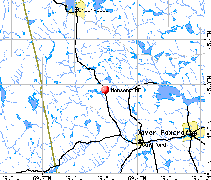
Points of interest:
Notable locations in Monson: Finn Hall (A), Monson Volunteer Fire Department (B). Display/hide their locations on the map
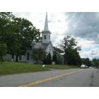
Church in Monson: Monson Community Church (A). Display/hide its location on the map
Cemeteries: Monson Cemetery (1), Hillside Cemetery (2), Lake Road Cemetery (3). Display/hide their locations on the map
Lakes, reservoirs, and swamps: Towne Pond (A), Bell Pond (B), Doe Pond (C), Doughty Ponds (D), Eighteen Pond (E), Eighteen Quarry Pond (F), Lily Pond (G), Meadow Pond (H). Display/hide their locations on the map
Streams, rivers, and creeks: North Pond Brook (A), Goodell Brook (B), Hammond Brook (C), Witham Brook (D), Peppermint Brook (E), Prescott Brook (F). Display/hide their locations on the map
Birthplace of: Olive Winchester - Theologian and minister.
Drinking water stations with addresses in Monson and their reported violations in the past:
MONSON UTILITIES DISTRICT (Population served: 303, Groundwater):Past monitoring violations:
- One routine major monitoring violation
- 13 regular monitoring violations
| This town: | 2.2 people |
| Maine: | 2.3 people |
| This town: | 60.1% |
| Whole state: | 62.9% |
| This town: | 7.5% |
| Whole state: | 9.4% |
No gay or lesbian households reported
| This town: | 15.7% |
| Whole state: | 10.9% |
| This town: | 7.2% |
| Whole state: | 4.1% |
For population 15 years and over in Monson:
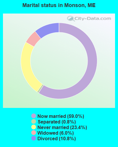
- Never married: 23.4%
- Now married: 59.0%
- Separated: 0.8%
- Widowed: 6.0%
- Divorced: 10.8%
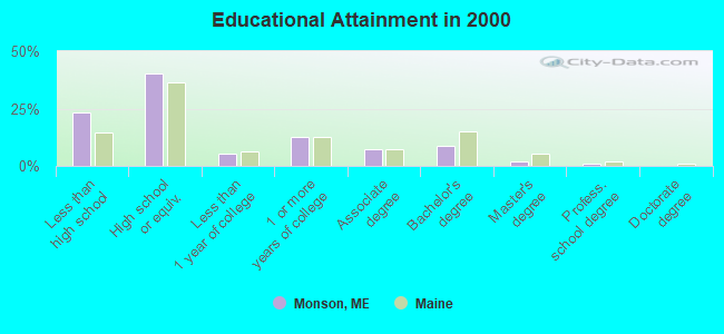
For population 25 years and over in Monson:
- High school or higher: 76.7%
- Bachelor's degree or higher: 11.6%
- Graduate or professional degree: 3.0%
- Unemployed: 8.8%
- Mean travel time to work (commute): 20.9 minutes
| Here: | 11.8 |
| Maine average: | 11.2 |
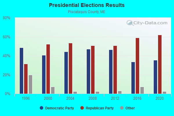
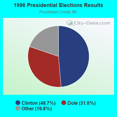
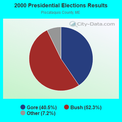
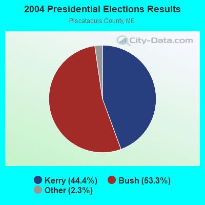
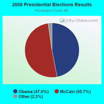
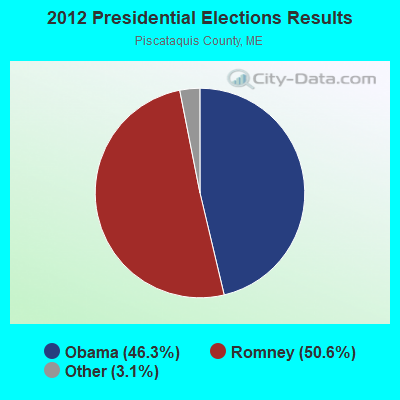
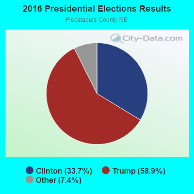
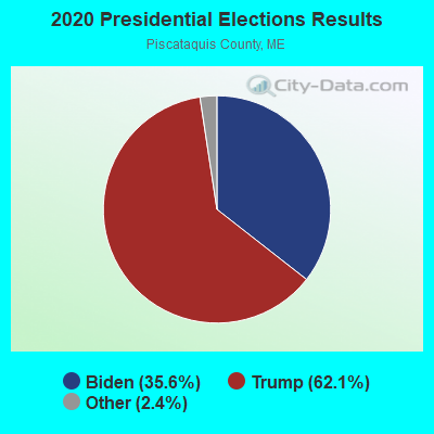
Graphs represent county-level data. Detailed 2008 Election Results
Religion statistics for Monson, ME (based on Piscataquis County data)
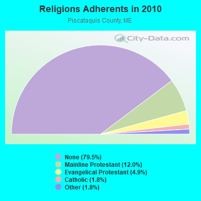
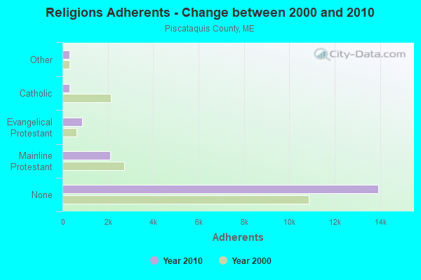
| Religion | Adherents | Congregations |
|---|---|---|
| Mainline Protestant | 2,108 | 13 |
| Evangelical Protestant | 855 | 13 |
| Catholic | 320 | 3 |
| Other | 318 | 5 |
| None | 13,934 | - |
Food Environment Statistics:
| Piscataquis County: | 5.24 / 10,000 pop. |
| State: | 2.80 / 10,000 pop. |
| Piscataquis County: | 4.08 / 10,000 pop. |
| Maine: | 2.20 / 10,000 pop. |
| Piscataquis County: | 8.74 / 10,000 pop. |
| State: | 5.75 / 10,000 pop. |
| This county: | 10.49 / 10,000 pop. |
| Maine: | 11.02 / 10,000 pop. |
| Piscataquis County: | 8.4% |
| Maine: | 8.2% |
| This county: | 27.5% |
| Maine: | 25.0% |
Strongest AM radio stations in Monson:
- WSKW (1160 AM; 10 kW; SKOWHEGAN, ME; Owner: MOUNTAIN WIRELESS, INCORPORATED)
- WZON (620 AM; 5 kW; BANGOR, ME; Owner: THE ZONE CORPORATION)
- WTME (780 AM; 10 kW; RUMFORD, ME; Owner: MOUNTAIN VALLEY BROADCASTING, INC.)
- WABI (910 AM; 5 kW; BANGOR, ME; Owner: CLEAR CHANNEL BROADCASTING LICENSES, INC.)
- WRKO (680 AM; 50 kW; BOSTON, MA; Owner: ENTERCOM BOSTON LICENSE, LLC)
- WCHP (760 AM; 35 kW; CHAMPLAIN, NY; Owner: CHAMPLAIN RADIO, INC.)
- WEEI (850 AM; 50 kW; BOSTON, MA; Owner: ENTERCOM BOSTON LICENSE, LLC)
- WNNZ (640 AM; 50 kW; WESTFIELD, MA; Owner: CLEAR CHANNEL BROADCASTING LICENSES, INC.)
- WBZ (1030 AM; 50 kW; BOSTON, MA; Owner: INFINITY BROADCASTING OPERATIONS, INC.)
- WCRN (830 AM; 50 kW; WORCESTER, MA; Owner: CARTER BROADCASTING CORPORATION)
- WKOX (1200 AM; 50 kW; FRAMINGHAM, MA; Owner: CAPSTAR TX LIMITED PARTNERSHIP)
- WALE (990 AM; 50 kW; GREENVILLE, RI; Owner: NORTH AMERICAN BROADCASTING CO., INC.)
- WGY (810 AM; 50 kW; SCHENECTADY, NY; Owner: CLEAR CHANNEL BROADCASTING LICENSES, INC.)
Strongest FM radio stations in Monson:
- WQCB (106.5 FM; BREWER, ME; Owner: CUMULUS LICENSING CORP.)
- WTOS-FM (105.1 FM; SKOWHEGAN, ME; Owner: CAPSTAR TX LIMITED PARTNERSHIP)
- WGUY (102.1 FM; DEXTER, ME; Owner: CONCORD MEDIA GROUP, INC.)
- WDME-FM (103.1 FM; DOVER-FOXCROFT, ME; Owner: THE ZONE CORPORATION)
- WVOM (103.9 FM; HOWLAND, ME; Owner: CLEAR CHANNEL BROADCASTING LICENSES, INC.)
- WWBX (97.1 FM; BANGOR, ME; Owner: CLEAR CHANNEL BROADCASTING LICENSES, INC.)
TV broadcast stations around Monson:
- W27CE (Channel 19; DOVER-FOXCROFT, ME; Owner: TRINITY BROADCASTING NETWORK)
Monson fatal accident list:
Sep 15, 2011 12:29 AM, Sr-15, Lat: 45.292642, Lon: -69.505606, Vehicles: 2, Persons: 2, Fatalities: 1
Jan 19, 2003 08:45 PM, Sr-15, Vehicles: 1, Persons: 3, Pedestrians: 1, Fatalities: 1, Drunk persons involved: 1
May 21, 1997 02:03 AM, 6, Vehicles: 1, Persons: 1, Fatalities: 1
Jun 6, 1988 10:15 PM, 70567057, Vehicles: 2, Persons: 2, Fatalities: 1, Drunk persons involved: 1
Jun 26, 1982 04:12 PM, 10851120, Vehicles: 1, Persons: 1, Fatalities: 1
- National Bridge Inventory (NBI) Statistics
- 1Number of bridges
- 13ft / 3.8mTotal length
- 154Total average daily traffic
- 7Total average daily truck traffic
- 246Total future (year 2036) average daily traffic
FCC Registered Broadcast Land Mobile Towers:
1- Main St (Lat: 45.284778 Lon: -69.499778), Call Sign: KQS623, Licensee ID: L00422608,
Assigned Frequencies: 154.310 MHz, Grant Date: 11/22/2001, Expiration Date: 12/31/2011, Cancellation Date: 03/03/2012, Registrant: Monson, Town Of, Main St, Monson, ME 04464, Phone: (207) 997-3641
FCC Registered Amateur Radio Licenses:
4- Call Sign: N1GTY, Licensee ID: L00384924, Grant Date: 08/09/2021, Expiration Date: 10/29/2031, Certifier: Ernest E Copeland Jr, Registrant: Ernest E Copeland Jr, Monson, ME 04464
- Call Sign: N1YRK, Licensee ID: L01246805, Grant Date: 04/11/2017, Expiration Date: 04/11/2027, Certifier: Robert W Keyes, Registrant: Robert W Keyes, 102 Greenville Road, Monson, ME 04464
- Call Sign: N2CLX, Licensee ID: L00290801, Grant Date: 09/13/2005, Expiration Date: 12/07/2015, Cancellation Date: 12/08/2017, Certifier: Mary L Shontz, Registrant: Mary L Shontz, 747 N Guilford Rd, Monson, ME 04464
- Call Sign: KC1QYY, Licensee ID: L02544277, Grant Date: 04/05/2022, Expiration Date: 04/05/2032, Certifier: Bruce C Erickson, Registrant: Bruce C Erickson, 57 Water St, Monson, ME 04464
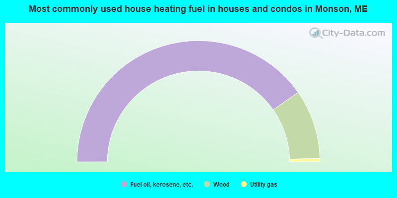
- 80.6%Fuel oil, kerosene, etc.
- 18.5%Wood
- 0.9%Utility gas
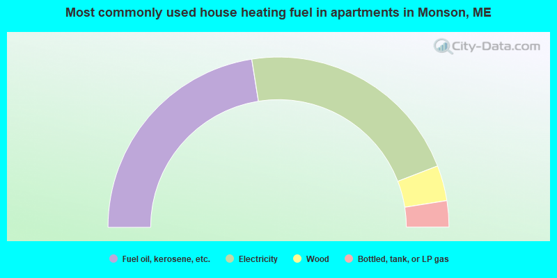
- 45.0%Fuel oil, kerosene, etc.
- 43.3%Electricity
- 6.7%Wood
- 5.0%Bottled, tank, or LP gas
Monson compared to Maine state average:
- Median house value below state average.
- Black race population percentage significantly below state average.
- Hispanic race population percentage below state average.
- Median age above state average.
- Foreign-born population percentage significantly below state average.
- Length of stay since moving in significantly above state average.
- Number of rooms per house significantly below state average.
- House age significantly below state average.
- Number of college students below state average.
- Percentage of population with a bachelor's degree or higher significantly below state average.