Monkton, Vermont
Submit your own pictures of this town and show them to the world
- OSM Map
- Google Map
- MSN Map
Population change since 2000: +12.6%
 |
| Males: 977 | |
| Females: 1,003 |
| Median resident age: | 41.3 years |
| Vermont median age: | 45.8 years |
Zip codes: 05443.
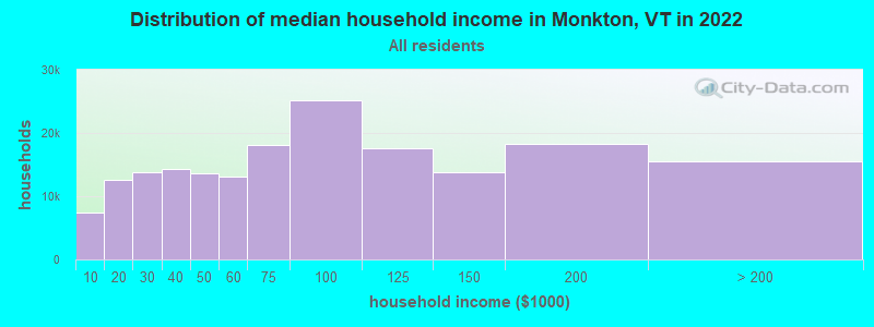
| Monkton: | $107,064 |
| VT: | $73,991 |
Estimated per capita income in 2022: $48,809 (it was $22,256 in 2000)
Monkton town income, earnings, and wages data
Estimated median house or condo value in 2022: $363,379 (it was $121,300 in 2000)
| Monkton: | $363,379 |
| VT: | $304,700 |
Mean prices in 2022: all housing units: $400,302; detached houses: $427,258; townhouses or other attached units: $389,241; in 2-unit structures: $373,341; in 3-to-4-unit structures: $633,103; in 5-or-more-unit structures: $292,995; mobile homes: $101,709
Detailed information about poverty and poor residents in Monkton, VT


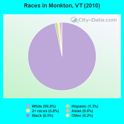
- 1,91696.8%White alone
- 251.3%Hispanic
- 150.8%Two or more races
- 110.6%Asian alone
- 90.5%Black alone
- 30.2%Other race alone
- 10.05%American Indian alone
Races in Monkton detailed stats: ancestries, foreign born residents, place of birth
 Recent articles from our blog. Our writers, many of them Ph.D. graduates or candidates, create easy-to-read articles on a wide variety of topics.
Ancestries: English (23.0%), Irish (16.4%), French (14.8%), United States (11.2%), German (9.6%), Italian (7.7%).
Current Local Time: EST time zone
Land area: 36.0 square miles.
Population density: 55 people per square mile (very low).
28 residents are foreign born
| This town: | 1.6% |
| Vermont: | 3.8% |
| Monkton town: | 1.9% ($2,259) |
| Vermont: | 2.0% ($2,196) |
Nearest city with pop. 50,000+: Schenectady, NY  (105.9 miles , pop. 61,821).
Nearest city with pop. 200,000+: Boston, MA (166.6 miles , pop. 589,141).
Nearest city with pop. 1,000,000+: Bronx, NY (236.4 miles , pop. 1,332,650).
Nearest cities:
), ), ), ), Latitude: 44.22 N, Longitude: 73.13 W
Area code commonly used in this area: 802
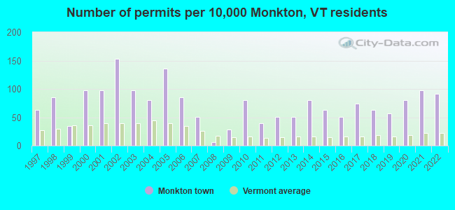
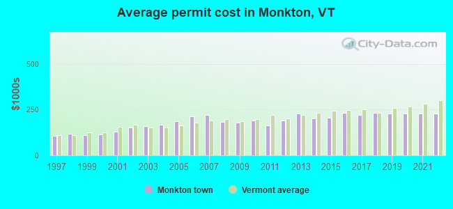
Single-family new house construction building permits:
- 2022: 16 buildings, average cost: $229,200
- 2021: 17 buildings, average cost: $229,200
- 2020: 14 buildings, average cost: $229,200
- 2019: 10 buildings, average cost: $228,900
- 2018: 11 buildings, average cost: $234,100
- 2017: 13 buildings, average cost: $221,100
- 2016: 9 buildings, average cost: $231,100
- 2015: 11 buildings, average cost: $205,500
- 2014: 14 buildings, average cost: $202,100
- 2013: 9 buildings, average cost: $228,900
- 2012: 9 buildings, average cost: $189,800
- 2011: 7 buildings, average cost: $163,600
- 2010: 14 buildings, average cost: $191,800
- 2009: 5 buildings, average cost: $180,300
- 2008: 1 building, cost: $182,400
- 2007: 9 buildings, average cost: $222,200
- 2006: 15 buildings, average cost: $213,700
- 2005: 24 buildings, average cost: $188,100
- 2004: 14 buildings, average cost: $168,900
- 2003: 17 buildings, average cost: $158,800
- 2002: 27 buildings, average cost: $153,000
- 2001: 17 buildings, average cost: $130,900
- 2000: 17 buildings, average cost: $113,500
- 1999: 6 buildings, average cost: $111,200
- 1998: 15 buildings, average cost: $119,300
- 1997: 11 buildings, average cost: $107,000
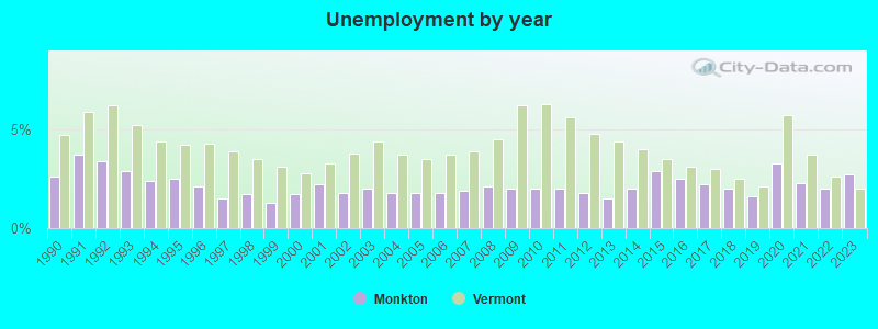
| Here: | 2.7% |
| Vermont: | 2.0% |
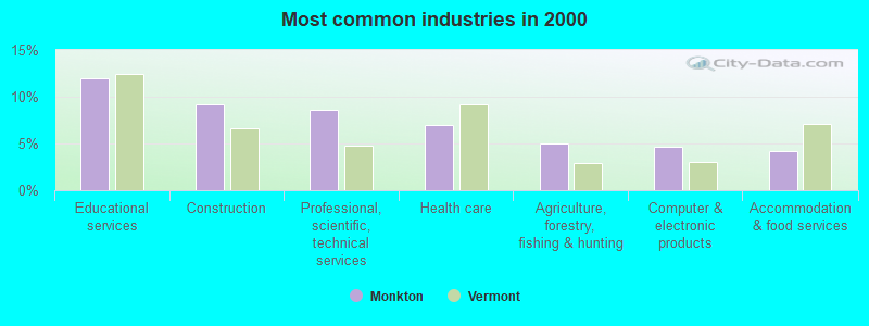
- Educational services (12.0%)
- Construction (9.2%)
- Professional, scientific, technical services (8.6%)
- Health care (6.9%)
- Agriculture, forestry, fishing & hunting (5.0%)
- Computer & electronic products (4.7%)
- Accommodation & food services (4.2%)
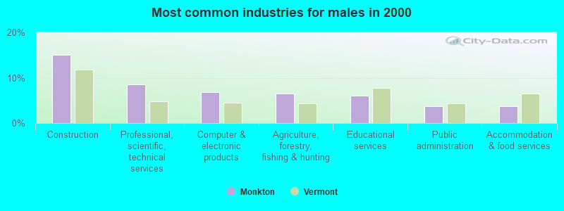
- Construction (15.0%)
- Professional, scientific, technical services (8.6%)
- Computer & electronic products (6.8%)
- Agriculture, forestry, fishing & hunting (6.6%)
- Educational services (6.0%)
- Public administration (3.6%)
- Accommodation & food services (3.6%)
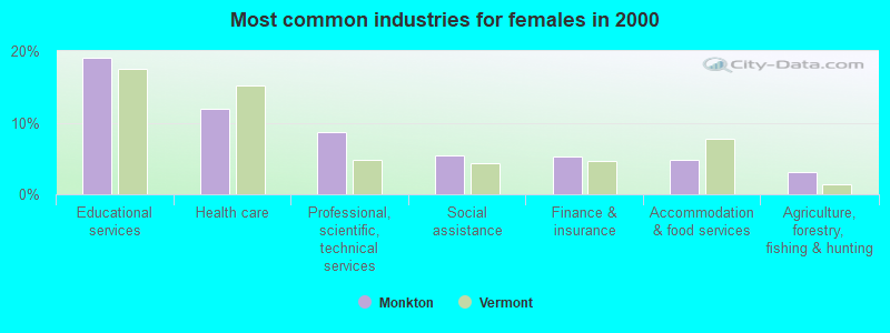
- Educational services (19.1%)
- Health care (12.0%)
- Professional, scientific, technical services (8.7%)
- Social assistance (5.4%)
- Finance & insurance (5.2%)
- Accommodation & food services (4.8%)
- Agriculture, forestry, fishing & hunting (3.0%)
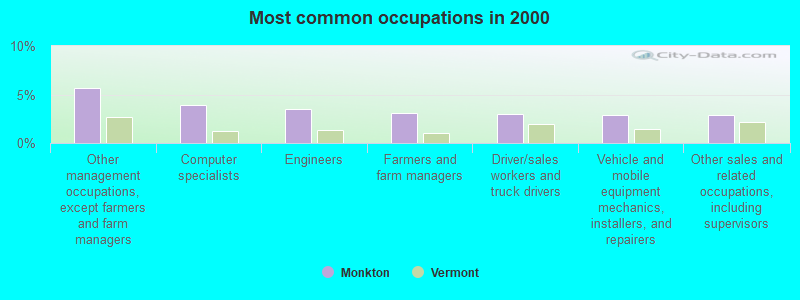
- Other management occupations, except farmers and farm managers (5.7%)
- Computer specialists (4.0%)
- Engineers (3.5%)
- Farmers and farm managers (3.1%)
- Driver/sales workers and truck drivers (3.0%)
- Vehicle and mobile equipment mechanics, installers, and repairers (2.9%)
- Other sales and related occupations, including supervisors (2.9%)
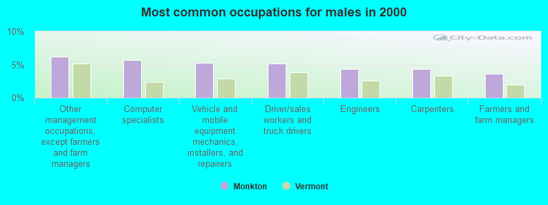
- Other management occupations, except farmers and farm managers (6.2%)
- Computer specialists (5.7%)
- Vehicle and mobile equipment mechanics, installers, and repairers (5.3%)
- Driver/sales workers and truck drivers (5.1%)
- Engineers (4.4%)
- Carpenters (4.4%)
- Farmers and farm managers (3.6%)
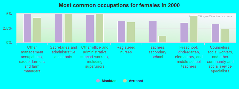
- Other management occupations, except farmers and farm managers (5.0%)
- Secretaries and administrative assistants (5.0%)
- Other office and administrative support workers, including supervisors (4.8%)
- Registered nurses (3.7%)
- Teachers, secondary school (3.7%)
- Preschool, kindergarten, elementary, and middle school teachers (3.5%)
- Counselors, social workers, and other community and social service specialists (3.3%)
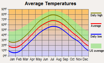
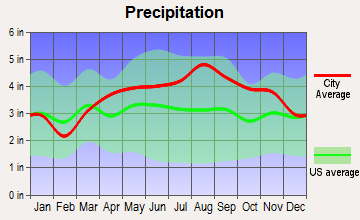
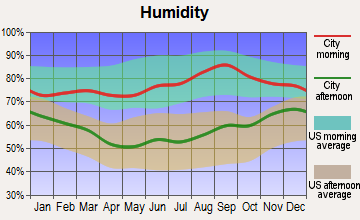
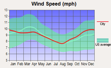
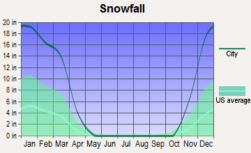
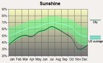
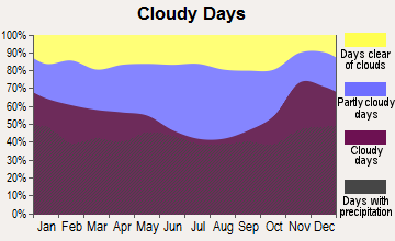
Average climate in Monkton, Vermont
Based on data reported by over 4,000 weather stations
(lower is better)
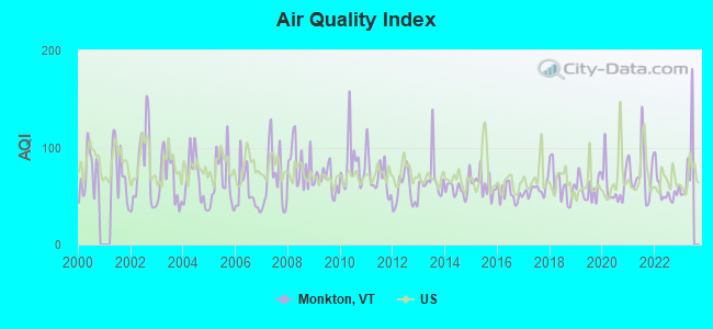
Air Quality Index (AQI) level in 2022 was 56.4. This is better than average.
| City: | 56.4 |
| U.S.: | 72.6 |
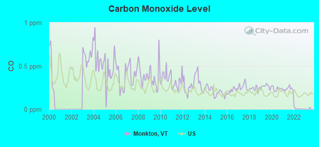
Carbon Monoxide (CO) [ppm] level in 2022 was 0.00585. This is significantly better than average. Closest monitor was 18.2 miles away from the city center.
| City: | 0.00585 |
| U.S.: | 0.25132 |
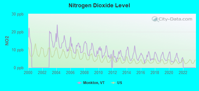
Nitrogen Dioxide (NO2) [ppb] level in 2021 was 4.81. This is about average. Closest monitor was 18.2 miles away from the city center.
| City: | 4.81 |
| U.S.: | 5.11 |
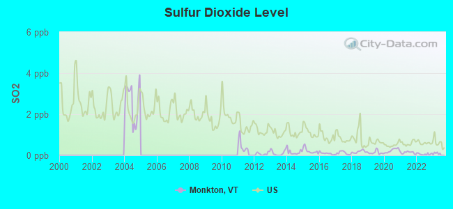
Sulfur Dioxide (SO2) [ppb] level in 2022 was 0.0619. This is significantly better than average. Closest monitor was 18.2 miles away from the city center.
| City: | 0.0619 |
| U.S.: | 1.5147 |
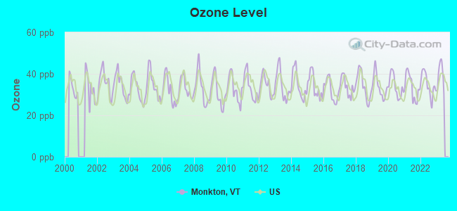
Ozone [ppb] level in 2022 was 34.8. This is about average. Closest monitor was 16.7 miles away from the city center.
| City: | 34.8 |
| U.S.: | 33.3 |
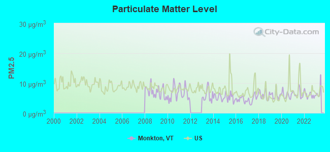
Particulate Matter (PM2.5) [µg/m3] level in 2022 was 6.04. This is better than average. Closest monitor was 18.2 miles away from the city center.
| City: | 6.04 |
| U.S.: | 8.11 |
Earthquake activity:
Monkton-area historical earthquake activity is significantly above Vermont state average. It is 71% smaller than the overall U.S. average.On 4/20/2002 at 10:50:47, a magnitude 5.3 (5.3 ML, Depth: 3.0 mi, Class: Moderate, Intensity: VI - VII) earthquake occurred 34.8 miles away from the city center
On 4/20/2002 at 10:50:47, a magnitude 5.2 (5.2 MB, 4.2 MS, 5.2 MW, 5.0 MW) earthquake occurred 34.6 miles away from the city center
On 10/7/1983 at 10:18:46, a magnitude 5.3 (5.1 MB, 5.3 LG, 5.1 ML) earthquake occurred 63.2 miles away from Monkton center
On 1/19/1982 at 00:14:42, a magnitude 4.7 (4.5 MB, 4.7 MD, 4.5 LG, Class: Light, Intensity: IV - V) earthquake occurred 90.9 miles away from Monkton center
On 10/16/2012 at 23:12:25, a magnitude 4.7 (4.7 ML, Depth: 10.0 mi) earthquake occurred 130.4 miles away from the city center
On 4/20/2002 at 11:04:42, a magnitude 3.7 (3.7 ML, Depth: 3.1 mi, Class: Light, Intensity: II - III) earthquake occurred 33.6 miles away from the city center
Magnitude types: regional Lg-wave magnitude (LG), body-wave magnitude (MB), duration magnitude (MD), local magnitude (ML), surface-wave magnitude (MS), moment magnitude (MW)
Natural disasters:
The number of natural disasters in Addison County (23) is greater than the US average (15).Major Disasters (Presidential) Declared: 16
Emergencies Declared: 3
Causes of natural disasters: Floods: 16, Storms: 15, Drought: 1, Heavy Rain: 1, Hurricane: 1, Ice Storm: 1, Landslide: 1, Snow: 1, Snowstorm: 1, Tornado: 1, Tropical Storm: 1, Wind: 1, Winter Storm: 1, Other: 1 (Note: some incidents may be assigned to more than one category).
Hospitals and medical centers near Monkton:
- CLARK NURSING HOME (Nursing Home, about 8 miles away; VERGENNES, VT)
- WAKE ROBIN-LINDEN NURSING HOME (Nursing Home, about 12 miles away; SHELBURNE, VT)
- PORTER HOSPITAL, INC Critical Access Hospitals (about 16 miles away; MIDDLEBURY, VT)
- HELEN PORTER HEALTHCARE AND REHAB (Nursing Home, about 16 miles away; MIDDLEBURY, VT)
Amtrak stations near Monkton:
- 17 miles: WESTPORT (HWY. 9 N. & D&H RAILROAD TRACKS) . Services: enclosed waiting area, public restrooms, public payphones, free short-term parking, free long-term parking.
- 19 miles: BURLINGTON-ESSEX JUNCTION (ESSEX JUNCTION, 29 RAILROAD AVE.) . Services: ticket office, partially wheelchair accessible, enclosed waiting area, public restrooms, public payphones, vending machines, ATM, free short-term parking, free long-term parking, call for car rental service, call for taxi service, public transit connection.
Colleges/universities with over 2000 students nearest to Monkton:
- Middlebury College (about 15 miles; Middlebury, VT; Full-time enrollment: 3,077)
- Champlain College (about 18 miles; Burlington, VT; FT enrollment: 2,623)
- University of Vermont (about 19 miles; Burlington, VT; FT enrollment: 11,566)
- Community College of Vermont (about 19 miles; Winooski, VT; FT enrollment: 3,394)
- Saint Michael's College (about 20 miles; Colchester, VT; FT enrollment: 2,336)
- Norwich University (about 24 miles; Northfield, VT; FT enrollment: 4,221)
- SUNY College at Plattsburgh (about 37 miles; Plattsburgh, NY; FT enrollment: 5,934)
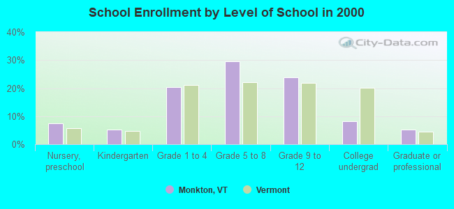
Public elementary/middle school in Monkton:
- MONKTON CENTRAL SCHOOL (Students: 184, Location: 1036 MONKTON ROAD, Grades: PK-6)
Points of interest:
Notable locations in Monkton: Huizenga Dairy Farm (A), Russell Memorial Library (B), Monkton Volunteer Fire Department (C). Display/hide their locations on the map
Church in Monkton: Monkton Church (A). Display/hide its location on the map
Cemeteries: Barnumtown Cemetery (1), Abel Thompson Cemetery (2), Horan Cemetery (3), Smith Cemetery (4), Ridge Cemetery (5), East Monkton Cemetery (6), Borough Cemetery (7). Display/hide their locations on the map
Lake: Cedar Lake (A). Display/hide its location on the map
Birthplace of: Frank Dupee - Major League Baseball pitcher.
| This town: | 2.7 people |
| Vermont: | 2.3 people |
| This town: | 77.1% |
| Whole state: | 62.5% |
| This town: | 9.6% |
| Whole state: | 9.2% |
Likely homosexual households (counted as self-reported same-sex unmarried-partner households)
- Lesbian couples: 1.6% of all households
- Gay men: 0.4% of all households
| This town: | 3.6% |
| Whole state: | 9.4% |
| This town: | 1.8% |
| Whole state: | 3.6% |
For population 15 years and over in Monkton:
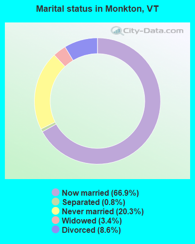
- Never married: 20.3%
- Now married: 66.9%
- Separated: 0.8%
- Widowed: 3.4%
- Divorced: 8.6%
For population 25 years and over in Monkton:
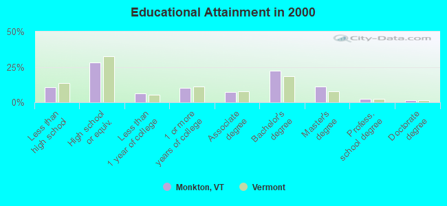
- High school or higher: 89.4%
- Bachelor's degree or higher: 37.1%
- Graduate or professional degree: 14.9%
- Unemployed: 3.4%
- Mean travel time to work (commute): 30.7 minutes
| Here: | 11.4 |
| Vermont average: | 11.7 |
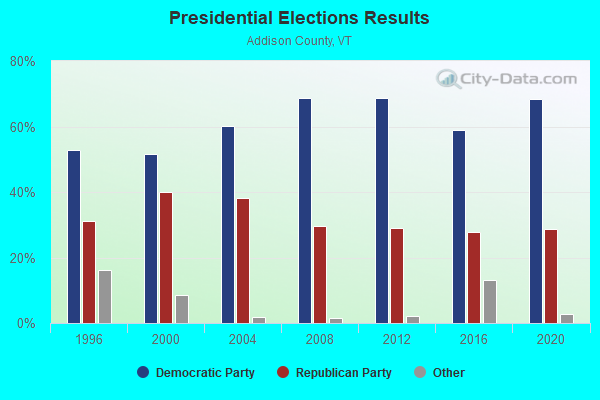
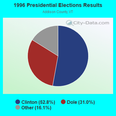

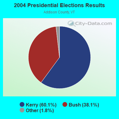
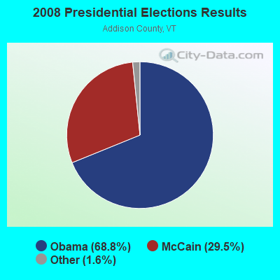
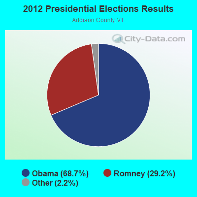
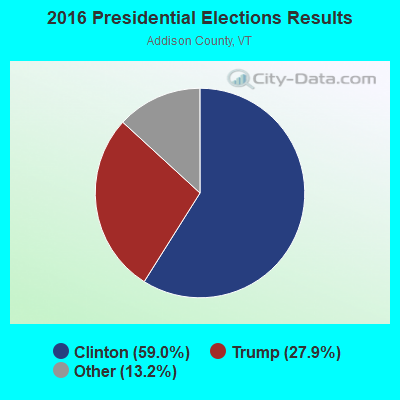
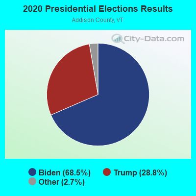
Graphs represent county-level data. Detailed 2008 Election Results
Religion statistics for Monkton, VT (based on Addison County data)
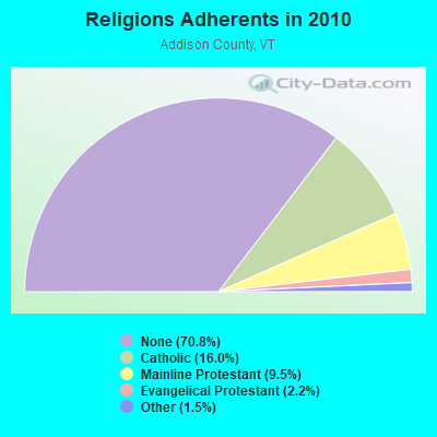
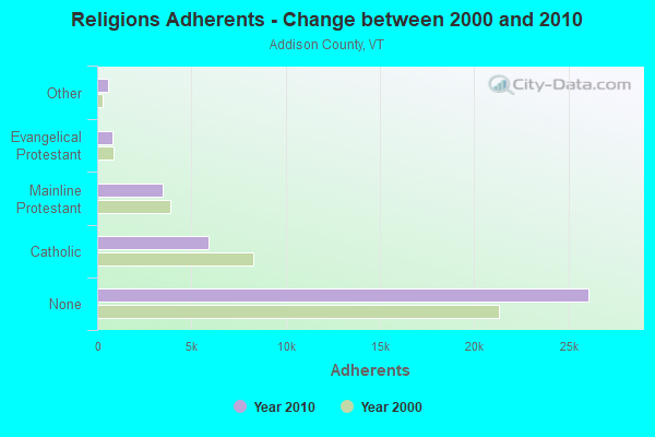
| Religion | Adherents | Congregations |
|---|---|---|
| Catholic | 5,892 | 6 |
| Mainline Protestant | 3,491 | 27 |
| Evangelical Protestant | 801 | 13 |
| Other | 560 | 6 |
| None | 26,077 | - |
Food Environment Statistics:
| Here: | 4.64 / 10,000 pop. |
| Vermont: | 3.84 / 10,000 pop. |
| Addison County: | 1.36 / 10,000 pop. |
| Vermont: | 1.95 / 10,000 pop. |
| This county: | 6.55 / 10,000 pop. |
| Vermont: | 6.40 / 10,000 pop. |
| Addison County: | 8.45 / 10,000 pop. |
| Vermont: | 11.52 / 10,000 pop. |
| Addison County: | 5.8% |
| Vermont: | 6.8% |
| Addison County: | 20.9% |
| Vermont: | 22.3% |
| Here: | 9.1% |
| Vermont: | 13.3% |
Strongest AM radio stations in Monkton:
- WDEV (550 AM; 5 kW; WATERBURY, VT; Owner: RADIO VERMONT, INC.)
- WCHP (760 AM; 35 kW; CHAMPLAIN, NY; Owner: CHAMPLAIN RADIO, INC.)
- WVMT (620 AM; 5 kW; BURLINGTON, VT; Owner: SISON BROADCASTING, INC.)
- WVAA (1390 AM; 5 kW; BURLINGTON, VT; Owner: RADIO VERMONT, KDR, LLC)
- WICY (1490 AM; 50 kW; MALONE, NY; Owner: CARTIER COMMUNICATIONS INC.)
- WEAV (960 AM; 5 kW; PLATTSBURGH, NY; Owner: CLEAR CHANNEL BROADCASTING LICENSES, INC.)
- WGY (810 AM; 50 kW; SCHENECTADY, NY; Owner: CLEAR CHANNEL BROADCASTING LICENSES, INC.)
- WTWK (1070 AM; daytime; 5 kW; PLATTSBURGH, NY; Owner: CHAMPLAIN COMMUNICATIONS CORPORATION)
- WNNZ (640 AM; 50 kW; WESTFIELD, MA; Owner: CLEAR CHANNEL BROADCASTING LICENSES, INC.)
- WJOY (1230 AM; 1 kW; BURLINGTON, VT; Owner: HALL COMMUNICATIONS, INC.)
- WRKO (680 AM; 50 kW; BOSTON, MA; Owner: ENTERCOM BOSTON LICENSE, LLC)
- WFAD (1490 AM; 1 kW; MIDDLEBURY, VT; Owner: ADDISON BROADCASTING COMPANY, INC.)
- WPTR (1540 AM; 50 kW; ALBANY, NY; Owner: KIMTRON, INC.)
Strongest FM radio stations in Monkton:
- WDEV-FM (96.1 FM; WARREN, VT; Owner: RADIO VERMONT, INC.)
- WCVT (101.7 FM; STOWE, VT; Owner: RADIO VERMONT CLASSICS, L.L.C.)
- WIZN (106.7 FM; VERGENNES, VT; Owner: BURLINGTON BROADCASTERS, INC.)
- WXZO (96.7 FM; WILLSBORO, NY; Owner: CAPSTAR TX LIMITED PARTNERSHIP)
- WNCS (104.7 FM; MONTPELIER, VT; Owner: MONTPELIER BROADCASTING, INC.)
- WVPS (107.9 FM; BURLINGTON, VT; Owner: VERMONT PUBLIC RADIO)
- WEZF (92.9 FM; BURLINGTON, VT; Owner: CAPSTAR TX LIMITED PARTNERSHIP)
- WLKC (103.3 FM; WATERBURY, VT; Owner: RADIO BROADCASTING SERVICES, INC.)
- WGLY-FM (91.5 FM; BOLTON, VT; Owner: CHRISTIAN MINISTRIES, INC.)
- WWFY (100.9 FM; BERLIN, VT; Owner: VOX ALLEGANY, LLC)
- WEBK (105.3 FM; KILLINGTON, VT; Owner: 6 JOHNSON ROAD LICENSES, INC.)
- WJJR (98.1 FM; RUTLAND, VT; Owner: 6 JOHNSON ROAD LICENSES, INC.)
- WZRT (97.1 FM; RUTLAND, VT; Owner: CAPSTAR TX LIMITED PARTNERSHIP)
- WGLV (91.7 FM; WOODSTOCK, VT; Owner: CHRISTIAN MINISTRIES INC)
- WHDQ-FM1 (106.1 FM; RUTLAND, VT; Owner: GREAT NORTHERN RADIO, L.L.C.)
- WCPV (101.3 FM; ESSEX, NY; Owner: CAPSTAR TX LIMITED PARTNERSHIP)
- WEXP (101.5 FM; BRANDON, VT; Owner: VOX VERMONT, L.L.C.)
- WCEL (91.9 FM; PLATTSBURGH, NY; Owner: WAMC)
- WJEN (94.5 FM; RUTLAND, VT; Owner: 6 JOHNSON ROAD LICENSES, INC.)
- WXLU (88.3 FM; PERU, NY; Owner: THE ST. LAWRENCE UNIVERSITY)
TV broadcast stations around Monkton:
- W25BT (Channel 25; MONKTON, VT; Owner: MOUNTAIN LAKES PUB.TELECOMM.COUNCIL)
- W62BY (Channel 62; MONKTON, VT; Owner: VERMONT WIRELESS COOPERATIVE)
- W64BP (Channel 64; MONKTON, VT; Owner: VERMONT WIRELESS COOPERATIVE)
- W66BX (Channel 66; MONKTON, VT; Owner: VERMONT WIRELESS COOPERATIVE)
- W68CK (Channel 68; MONKTON, VT; Owner: VERMONT WIRELESS COOPERATIVE)
- W19BR (Channel 19; MONKTON, VT; Owner: PLATTSBURGH PARTNERS)
- WPTZ (Channel 5; NORTH POLE, NY; Owner: HEARST-ARGYLE STATIONS, INC.)
- W16AL (Channel 16; BURLINGTON, VT; Owner: TRINITY BROADCASTING NETWORK)
Monkton fatal accident list:
Dec 4, 2003 08:11 AM, Fas-199, Vehicles: 2, Persons: 3, Fatalities: 1
Sep 23, 1997 12:40 AM, Fas 199, Vehicles: 2, Persons: 4, Fatalities: 1
- National Bridge Inventory (NBI) Statistics
- 2Number of bridges
- 10ft / 2.9mTotal length
- $241,000Total costs
- 550Total average daily traffic
- 11Total average daily truck traffic
- 578Total future (year 2029) average daily traffic
FCC Registered Cell Phone Towers:
1 (See the full list of FCC Registered Cell Phone Towers in Monkton)FCC Registered Antenna Towers:
11 (See the full list of FCC Registered Antenna Towers)FCC Registered Broadcast Land Mobile Towers:
3- Boro Hill Rd (Lat: 44.223389 Lon: -73.123722), Type: Tower, Structure height: 50 m, Overall height: 53 m, Call Sign: KCD610,
Assigned Frequencies: 451.062 MHz, 48.5400 MHz, Grant Date: 02/09/2012, Expiration Date: 04/02/2022, Cancellation Date: 03/14/2022, Certifier: Noel C Christie, Registrant: Green Mountain Power Corp, 2152 Post Rd, Rutland, VT 05701, Phone: (802) 770-3210, Fax: (802) 770-3499, Email:
- MONKTON, 682 Wendland Rd (Lat: 44.225278 Lon: -73.124167), Type: Gtower, Structure height: 10.7 m, Call Sign: WRFN776,
Assigned Frequencies: 46.4600 MHz, Grant Date: 04/03/2020, Expiration Date: 04/03/2030, Certifier: Donald Jaquish, Registrant: V-Comm, L.L.C, 2147 Route 27, Suite 102, Edison, NJ 08817, Phone: (609) 655-1200, Email:
- MONKTON, 682 Wendland Rd (Lat: 44.225278 Lon: -73.124167), Type: Gtower, Structure height: 10.7 m, Call Sign: WRFV905,
Assigned Frequencies: 155.190 MHz, 155.430 MHz, 155.670 MHz, Grant Date: 05/13/2020, Expiration Date: 05/13/2030, Certifier: Donald Jaquish, Registrant: V-Comm L.L.C, 2540 Us Hwy 130 Suite 101, Cranbury, NJ 08512, Phone: (609) 655-1200, Fax: (609) 409-1927, Email:
FCC Registered Microwave Towers:
1- MONKTON, 686 Wendland Rd (Lat: 44.225333 Lon: -73.124306), Type: Mast, Structure height: 6.1 m, Call Sign: WRMU930, Licensee ID: L00049460,
Assigned Frequencies: 6226.89 MHz, Grant Date: 06/08/2021, Expiration Date: 06/08/2031, Certifier: Max Thwaits, Registrant: Essex County Office Of Emergency Srv-Ny, P.O. Box 30 702 Stowersville Rd., Lewis, NY 12950, Phone: (518) 873-3902, Fax: (518) 873-3963, Email:
FCC Registered Paging Towers:
1- Off Boro Hill Road (Lat: 44.223333 Lon: -73.124167), Type: Tower, Structure height: 47.2 m, Call Sign: KNKK601,
Assigned Frequencies: 152.600 MHz, Grant Date: 04/23/2019, Expiration Date: 04/01/2029, Registrant: Wilkinson Barker Knauer, LLP, 1800 M Street, N.W., Suite 800n, Washington, DC 20036, Phone: (202) 783-4141, Fax: (202) 783-5851, Email:
FCC Registered Amateur Radio Licenses:
2- Call Sign: NT1O, Licensee ID: L01373530, Grant Date: 02/26/2008, Expiration Date: 05/22/2018, Cancellation Date: 05/21/2018, Certifier: David M Boyer, Registrant: David M Boyer, Box 5, Monkton, VT 05469
- Call Sign: KC1JHW, Licensee ID: L01468601, Grant Date: 03/26/2018, Expiration Date: 03/26/2028, Certifier: Peter E Wendland, Registrant: Peter E Wendland, Monkton, VT 05469
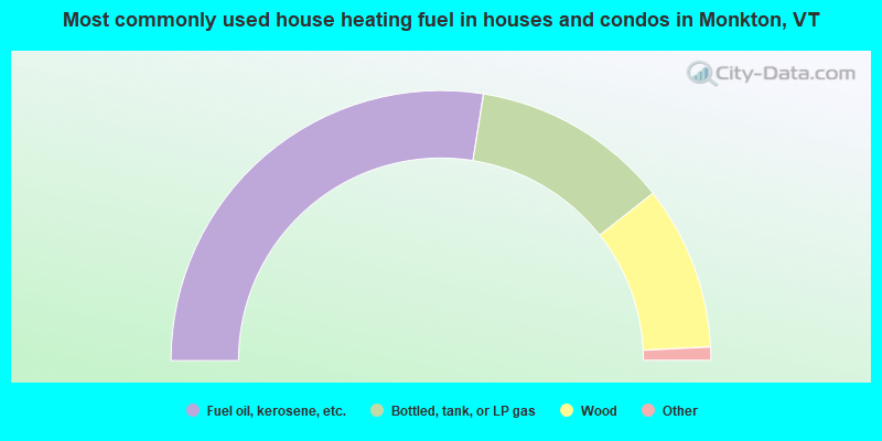
- 55.1%Fuel oil, kerosene, etc.
- 23.7%Bottled, tank, or LP gas
- 19.7%Wood
- 1.2%Electricity
- 0.3%Utility gas
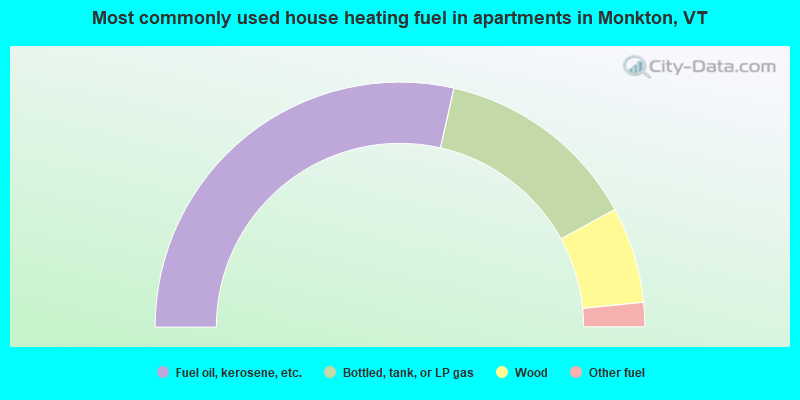
- 57.1%Fuel oil, kerosene, etc.
- 27.0%Bottled, tank, or LP gas
- 12.7%Wood
- 3.2%Other fuel
Monkton compared to Vermont state average:
- Unemployed percentage significantly below state average.
- Black race population percentage below state average.
- Median age below state average.
- Foreign-born population percentage significantly below state average.
- Renting percentage significantly below state average.
- Length of stay since moving in significantly above state average.
- Number of rooms per house significantly below state average.
- House age significantly below state average.
- Number of college students below state average.

|
Total of 19 patent applications in 2008-2024.