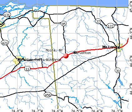
Moira, New York
Submit your own pictures of this town and show them to the world
- OSM Map
- General Map
- Google Map
- MSN Map
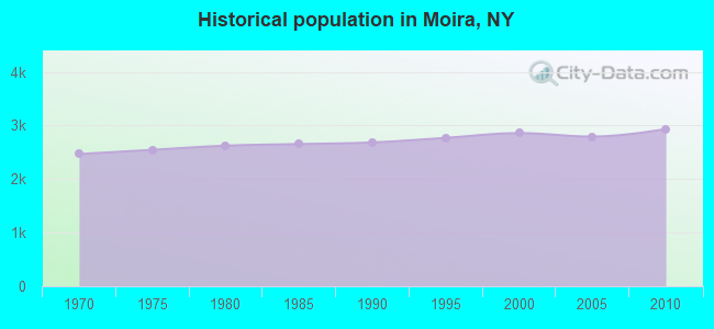
Population change since 2000: +2.7%
 |
| Males: 1,441 | |
| Females: 1,493 |
| Median resident age: | 39.0 years |
| New York median age: | 40.7 years |
Zip codes: 12957.
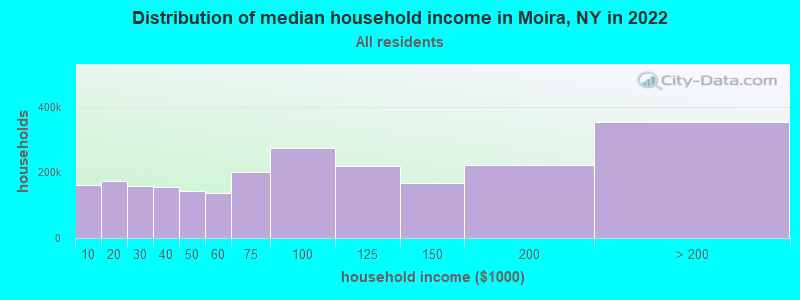
| Moira: | $49,337 |
| NY: | $79,557 |
Estimated per capita income in 2022: $25,533 (it was $13,270 in 2000)
Moira town income, earnings, and wages data
Estimated median house or condo value in 2022: $103,523 (it was $44,900 in 2000)
| Moira: | $103,523 |
| NY: | $400,400 |
Mean prices in 2022: all housing units: $219,333; detached houses: $244,011; townhouses or other attached units: $364,147; in 2-unit structures: $197,583; in 3-to-4-unit structures: $157,263; in 5-or-more-unit structures: $800,159; mobile homes: $60,247
Detailed information about poverty and poor residents in Moira, NY
Compare current foreclosures near Moira, NY:
| Photo | Address | Area | Beds / Baths | Price | Details |
|---|---|---|---|---|---|

|
#1
Larue Rd
Massena, NY 13662
|
- sq. feet
|
- baths - beds |
$49,900
|
show details |

|
#2
County Route 25
Malone, NY 12953
|
768 sq. feet
|
1 baths 2 beds |
show details | |

|
#3
Harding St
Malone, NY 12953
|
1,248 sq. feet
|
1 baths 3 beds |
show details | |

|
#4
State Highway 420 # 420
Norfolk, NY 13667
|
1,212 sq. feet
|
1 baths 3 beds |
show details | |

|
#5
Lincoln Bridge Rd
Winthrop, NY 13697
|
1,176 sq. feet
|
1 baths 3 beds |
show details | |

|
#6
Low Rd
Malone, NY 12953
|
1,504 sq. feet
|
2 baths 2 beds |
show details | |

|
#7
State Highway 11c
Winthrop, NY 13697
|
1,498 sq. feet
|
1 baths 3 beds |
show details | |

|
#8
Willow St
Malone, NY 12953
|
1,645 sq. feet
|
1 baths 5 beds |
show details | |

|
#9
Hopkins Point Rd
Fort Covington, NY 12937
|
1,024 sq. feet
|
1 baths 3 beds |
show details | |

|
#10
Vice Rd
Brasher Falls, NY 13613
|
1,455 sq. feet
|
1 baths 4 beds |
show details |
| Photo | Address | Area | Beds / Baths | Price | Details |
|---|---|---|---|---|---|

|
#11
County Route 5
Dickinson Center, NY 12930
|
1,323 sq. feet
|
1 baths 3 beds |
show details | |

|
#12
State Route 11
North Bangor, NY 12966
|
1,780 sq. feet
|
2 baths 3 beds |
show details | |

|
#13
Grove St
North Lawrence, NY 12967
|
1,632 sq. feet
|
1 baths 4 beds |
show details | |

|
#14
County Route 10
North Bangor, NY 12966
|
1,315 sq. feet
|
1 baths 4 beds |
show details | |

|
#15
Wagner Rd
Brushton, NY 12916
|
980 sq. feet
|
- baths - beds |
show details | |

|
#16
Porter Ave
Malone, NY 12953
|
- sq. feet
|
- baths - beds |
show details | |

|
#17
State Route 37
Malone, NY 12953
|
- sq. feet
|
- baths - beds |
show details | |

|
#18
Carey Rd
Massena, NY 13662
|
- sq. feet
|
- baths - beds |
show details | |

|
#19
Henry Rd
Malone, NY 12953
|
- sq. feet
|
- baths - beds |
show details | |

|
#20
Hopson Rd
Massena, NY 13662
|
- sq. feet
|
- baths - beds |
show details |
| Photo | Address | Area | Beds / Baths | Price | Details |
|---|---|---|---|---|---|

|
#21
Maple Leaf Ln Apt C1
Brushton, NY 12916
|
- sq. feet
|
- baths - beds |
show details | |

|
Check over 1 million property listings on Foreclosure.com!
|
browse all offers | |||

- 2,84697.0%White alone
- 331.1%American Indian alone
- 170.6%Asian alone
- 190.6%Two or more races
- 180.6%Hispanic
- 10.03%Black alone
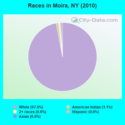
Races in Moira detailed stats: ancestries, foreign born residents, place of birth
According to our research of New York and other state lists, there were 7 registered sex offenders living in Moira, New York as of May 09, 2024.
The ratio of all residents to sex offenders in Moira is 419 to 1.
 Recent articles from our blog. Our writers, many of them Ph.D. graduates or candidates, create easy-to-read articles on a wide variety of topics.

 | Asian communities in Upstate NY (596 replies) |
| Downstate counties have highest rates of students in private schools. Check your district (3 replies) |
| The Upstate NY Pronunciation Guide! (81 replies) |
| Place names that look or sound alike! (31 replies) |
| Anyone able to share some school budget results? (165 replies) |
| Top-Rated Public School Districts in Syracuse area (6 replies) |
Latest news from Moira, NY collected exclusively by city-data.com from local newspapers, TV, and radio stations
Ancestries: French (25.9%), Irish (16.1%), United States (15.0%), English (13.7%), French Canadian (7.4%), German (4.6%).
Current Local Time: EST time zone
Land area: 45.2 square miles.
Population density: 65 people per square mile (very low).

52 residents are foreign born
| This town: | 1.8% |
| New York: | 20.4% |
| Moira town: | 2.0% ($880) |
| New York: | 1.9% ($2,847) |
Nearest city with pop. 50,000+: Utica, NY  (124.7 miles , pop. 60,651).
Nearest city with pop. 200,000+: Rochester, NY (191.1 miles , pop. 219,773).
Nearest city with pop. 1,000,000+: Bronx, NY (277.6 miles , pop. 1,332,650).
Nearest cities:
), ), ), ), )Latitude: 44.83 N, Longitude: 74.55 W
Area code: 518

| Here: | 4.6% |
| New York: | 4.4% |
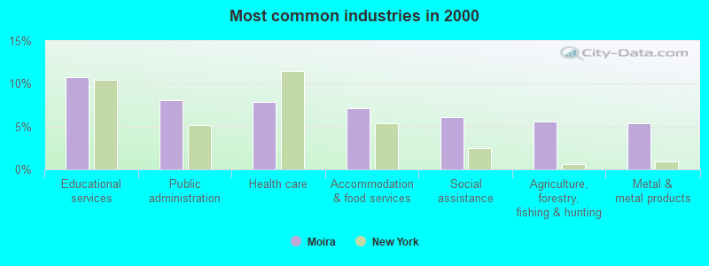
- Educational services (10.7%)
- Public administration (8.1%)
- Health care (7.9%)
- Accommodation & food services (7.1%)
- Social assistance (6.1%)
- Agriculture, forestry, fishing & hunting (5.6%)
- Metal & metal products (5.4%)
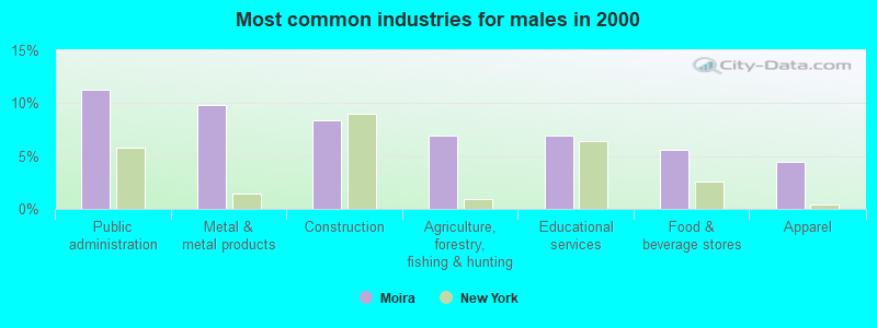
- Public administration (11.2%)
- Metal & metal products (9.8%)
- Construction (8.4%)
- Agriculture, forestry, fishing & hunting (7.0%)
- Educational services (7.0%)
- Food & beverage stores (5.5%)
- Apparel (4.4%)
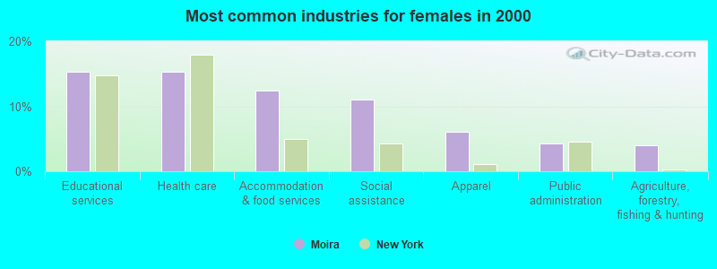
- Educational services (15.3%)
- Health care (15.3%)
- Accommodation & food services (12.4%)
- Social assistance (11.1%)
- Apparel (6.1%)
- Public administration (4.2%)
- Agriculture, forestry, fishing & hunting (4.0%)
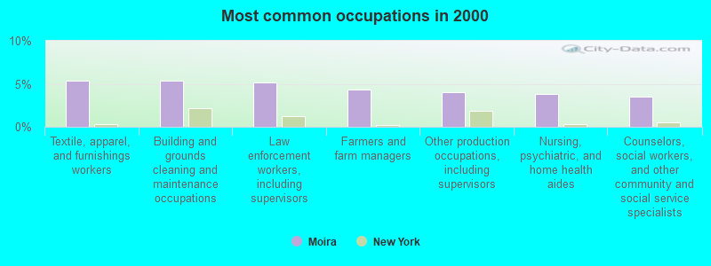
- Textile, apparel, and furnishings workers (5.4%)
- Building and grounds cleaning and maintenance occupations (5.4%)
- Law enforcement workers, including supervisors (5.1%)
- Farmers and farm managers (4.3%)
- Other production occupations, including supervisors (4.0%)
- Nursing, psychiatric, and home health aides (3.8%)
- Counselors, social workers, and other community and social service specialists (3.5%)
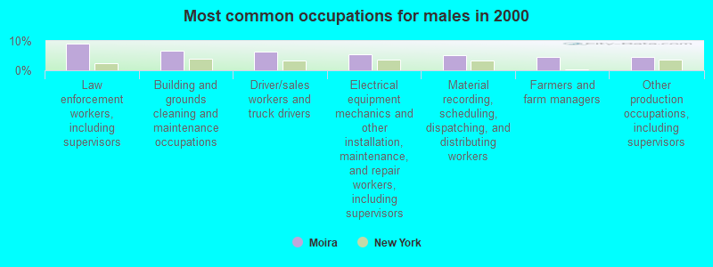
- Law enforcement workers, including supervisors (9.0%)
- Building and grounds cleaning and maintenance occupations (6.8%)
- Driver/sales workers and truck drivers (6.3%)
- Electrical equipment mechanics and other installation, maintenance, and repair workers, including supervisors (5.4%)
- Material recording, scheduling, dispatching, and distributing workers (5.2%)
- Farmers and farm managers (4.6%)
- Other production occupations, including supervisors (4.4%)
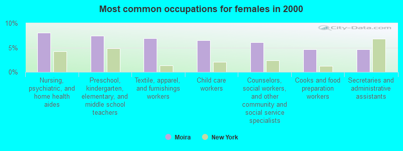
- Nursing, psychiatric, and home health aides (8.0%)
- Preschool, kindergarten, elementary, and middle school teachers (7.5%)
- Textile, apparel, and furnishings workers (6.9%)
- Child care workers (6.5%)
- Counselors, social workers, and other community and social service specialists (6.1%)
- Cooks and food preparation workers (4.6%)
- Secretaries and administrative assistants (4.6%)
Average climate in Moira, New York
Based on data reported by over 4,000 weather stations


(lower is better)
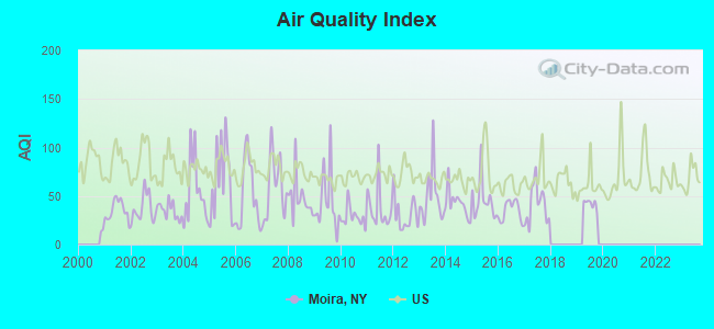
Air Quality Index (AQI) level in 2019 was 41.9. This is significantly better than average.
| City: | 41.9 |
| U.S.: | 72.6 |
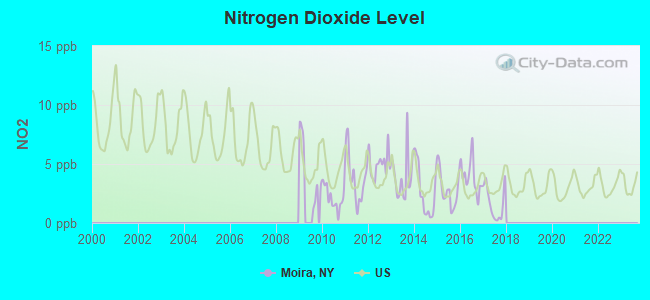
Nitrogen Dioxide (NO2) [ppb] level in 2017 was 1.66. This is significantly better than average. Closest monitor was 12.7 miles away from the city center.
| City: | 1.66 |
| U.S.: | 5.11 |
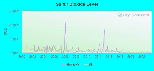
Sulfur Dioxide (SO2) [ppb] level in 2017 was 1.08. This is significantly better than average. Closest monitor was 12.7 miles away from the city center.
| City: | 1.08 |
| U.S.: | 1.51 |
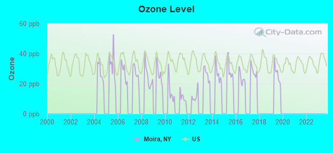
Ozone [ppb] level in 2019 was 26.9. This is better than average. Closest monitor was 12.7 miles away from the city center.
| City: | 26.9 |
| U.S.: | 33.3 |
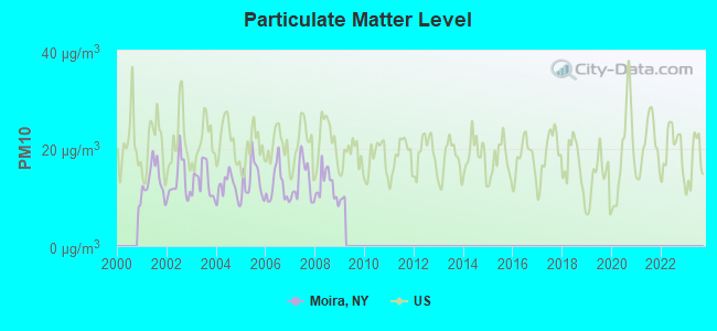
Particulate Matter (PM10) [µg/m3] level in 2008 was 12.5. This is significantly better than average. Closest monitor was 12.7 miles away from the city center.
| City: | 12.5 |
| U.S.: | 19.2 |
Earthquake activity:
Moira-area historical earthquake activity is above New York state average. It is 77% smaller than the overall U.S. average.On 4/20/2002 at 10:50:47, a magnitude 5.3 (5.3 ML, Depth: 3.0 mi, Class: Moderate, Intensity: VI - VII) earthquake occurred 47.2 miles away from Moira center
On 10/7/1983 at 10:18:46, a magnitude 5.3 (5.1 MB, 5.3 LG, 5.1 ML) earthquake occurred 61.5 miles away from the city center
On 4/20/2002 at 10:50:47, a magnitude 5.2 (5.2 MB, 4.2 MS, 5.2 MW, 5.0 MW) earthquake occurred 47.2 miles away from the city center
On 1/19/1982 at 00:14:42, a magnitude 4.7 (4.5 MB, 4.7 MD, 4.5 LG, Class: Light, Intensity: IV - V) earthquake occurred 172.7 miles away from the city center
On 10/16/2012 at 23:12:25, a magnitude 4.7 (4.7 ML, Depth: 10.0 mi) earthquake occurred 210.9 miles away from Moira center
On 4/8/2003 at 15:06:14, a magnitude 3.7 (3.7 MB, Depth: 6.2 mi, Class: Light, Intensity: II - III) earthquake occurred 18.0 miles away from Moira center
Magnitude types: regional Lg-wave magnitude (LG), body-wave magnitude (MB), duration magnitude (MD), local magnitude (ML), surface-wave magnitude (MS), moment magnitude (MW)
Natural disasters:
The number of natural disasters in Franklin County (15) is near the US average (15).Major Disasters (Presidential) Declared: 9
Emergencies Declared: 5
Causes of natural disasters: Floods: 5, Storms: 5, Hurricanes: 3, Winter Storms: 2, Blizzard: 1, Earthquake: 1, Power Outage: 1, Snowstorm: 1, Tornado: 1, Wind: 1, Other: 2 (Note: some incidents may be assigned to more than one category).

Hospitals and medical centers near Moira:
- CITIZEN ADVOCATES D/B/A NORTHSTAR INDUSTRIES, INC (Hospital, about 12 miles away; MALONE, NY)
- FRANKLIN COUNTY NURSING HOME (Nursing Home, about 13 miles away; MALONE, NY)
- FRANKLIN COUNTY PUBLIC HEALTH SERVICES CHHA (Home Health Center, about 13 miles away; MALONE, NY)
- ALICE HYDE MEDICAL CENTER Acute Care Hospitals (about 13 miles away; MALONE, NY)
Colleges/universities with over 2000 students nearest to Moira:
- SUNY College at Potsdam (about 25 miles; Potsdam, NY; Full-time enrollment: 4,307)
- Clarkson University (about 26 miles; Potsdam, NY; FT enrollment: 3,472)
- St Lawrence University (about 35 miles; Canton, NY; FT enrollment: 2,501)
- SUNY College of Technology at Canton (about 35 miles; Canton, NY; FT enrollment: 3,411)
- SUNY College at Plattsburgh (about 54 miles; Plattsburgh, NY; FT enrollment: 5,934)
- Champlain College (about 71 miles; Burlington, VT; FT enrollment: 2,623)
- University of Vermont (about 71 miles; Burlington, VT; FT enrollment: 11,566)
Points of interest:
Notable location: Brushton Volunteer Fire Department (A). Display/hide its location on the map
Churches in Moira include: Evangelical Wesleyan Church (A), First Christian Church (B), Saint Mary's Church (C), Saint Mary's Parish Center (D). Display/hide their locations on the map
Cemeteries: Saint Marys Cemetery (1), Saint Peters Cemetery (2), Moira Community Cemetery (3), Sunnyside Cemetery (4). Display/hide their locations on the map
Streams, rivers, and creeks: Stony Brook (A), Farrington Brook (B), Alburg Brook (C), Joy Brook (D). Display/hide their locations on the map
Drinking water stations with addresses in Moira and their reported violations in the past:
COUNTRYSIDE COMMUNITY MP INC (Address: 89 BUCKWHEAT ROAD, UNIT 30 , Population served: 100, Groundwater):Past monitoring violations:MARTINS COUNTRY STORE & FARM CENTER (Address: 697 COUNTY ROUTE 6 , Population served: 25, Groundwater):
- 3 routine major monitoring violations
Past monitoring violations:
- 2 routine major monitoring violations
| This town: | 2.5 people |
| New York: | 2.6 people |
| This town: | 65.1% |
| Whole state: | 63.5% |
| This town: | 11.5% |
| Whole state: | 6.8% |
Likely homosexual households (counted as self-reported same-sex unmarried-partner households)
- Lesbian couples: 0.3% of all households
- Gay men: 0.2% of all households
| This town: | 18.4% |
| Whole state: | 14.6% |
| This town: | 9.7% |
| Whole state: | 7.4% |
6 people in religious group quarters in 2000
For population 15 years and over in Moira:
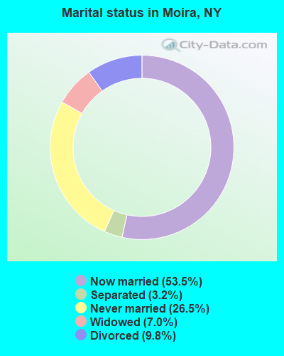
- Never married: 26.5%
- Now married: 53.5%
- Separated: 3.2%
- Widowed: 7.0%
- Divorced: 9.8%
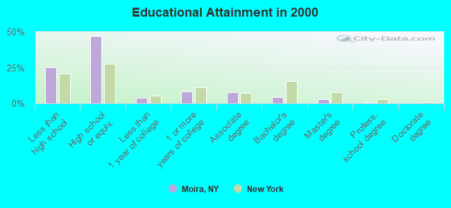
For population 25 years and over in Moira:
- High school or higher: 74.6%
- Bachelor's degree or higher: 7.1%
- Graduate or professional degree: 3.0%
- Unemployed: 12.4%
- Mean travel time to work (commute): 25.9 minutes
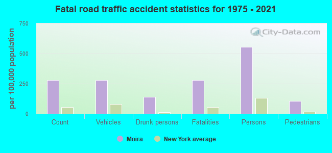
| Here: | 10.7 |
| New York average: | 14.2 |
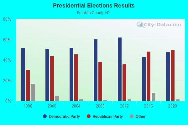
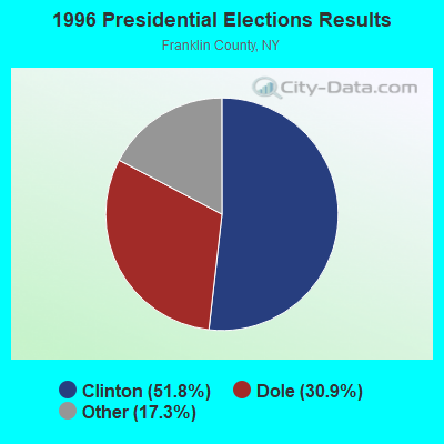
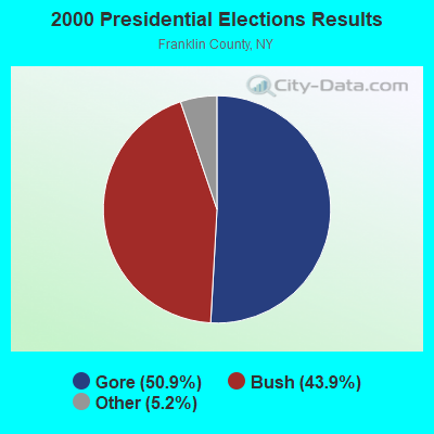
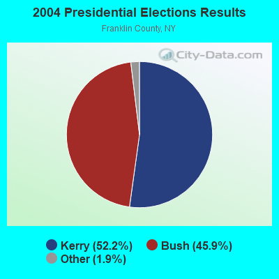
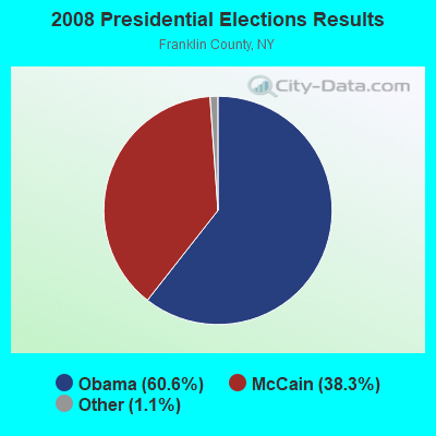
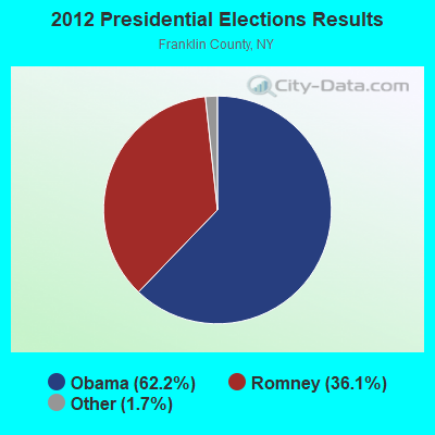


Graphs represent county-level data. Detailed 2008 Election Results
Religion statistics for Moira, NY (based on Franklin County data)
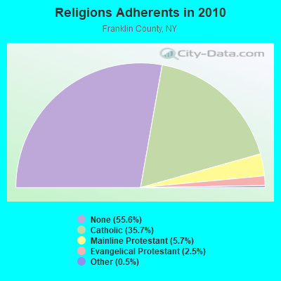
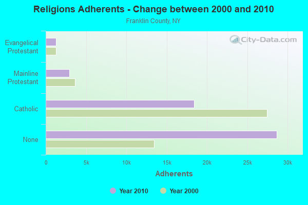
| Religion | Adherents | Congregations |
|---|---|---|
| Catholic | 18,437 | 21 |
| Mainline Protestant | 2,942 | 26 |
| Evangelical Protestant | 1,277 | 19 |
| Other | 253 | 4 |
| None | 28,690 | - |
Food Environment Statistics:
| Franklin County: | 3.57 / 10,000 pop. |
| New York: | 4.13 / 10,000 pop. |
| Here: | 1.39 / 10,000 pop. |
| New York: | 0.92 / 10,000 pop. |
| Franklin County: | 4.96 / 10,000 pop. |
| State: | 1.68 / 10,000 pop. |
| This county: | 6.94 / 10,000 pop. |
| New York: | 8.82 / 10,000 pop. |
| Franklin County: | 8.2% |
| New York: | 8.2% |
| Here: | 26.3% |
| New York: | 23.8% |
| Franklin County: | 13.7% |
| State: | 15.6% |
Strongest AM radio stations in Moira:
- WICY (1490 AM; 50 kW; MALONE, NY; Owner: CARTIER COMMUNICATIONS INC.)
- WCHP (760 AM; 35 kW; CHAMPLAIN, NY; Owner: CHAMPLAIN RADIO, INC.)
- WGY (810 AM; 50 kW; SCHENECTADY, NY; Owner: CLEAR CHANNEL BROADCASTING LICENSES, INC.)
- WMSA (1340 AM; 1 kW; MASSENA, NY; Owner: SEAWAY BROADCASTING, INC.)
- WYBG (1050 AM; 1 kW; MASSENA, NY)
- WIRD (920 AM; 5 kW; LAKE PLACID, NY; Owner: RADIO LAKE PLACID INC)
- WNNZ (640 AM; 50 kW; WESTFIELD, MA; Owner: CLEAR CHANNEL BROADCASTING LICENSES, INC.)
- WVMT (620 AM; 5 kW; BURLINGTON, VT; Owner: SISON BROADCASTING, INC.)
- WEAV (960 AM; 5 kW; PLATTSBURGH, NY; Owner: CLEAR CHANNEL BROADCASTING LICENSES, INC.)
- WPTR (1540 AM; 50 kW; ALBANY, NY; Owner: KIMTRON, INC.)
- WTWK (1070 AM; daytime; 5 kW; PLATTSBURGH, NY; Owner: CHAMPLAIN COMMUNICATIONS CORPORATION)
- WRKO (680 AM; 50 kW; BOSTON, MA; Owner: ENTERCOM BOSTON LICENSE, LLC)
- WCRN (830 AM; 50 kW; WORCESTER, MA; Owner: CARTER BROADCASTING CORPORATION)
Strongest FM radio stations in Moira:
- WYUL (94.7 FM; CHATEAUGAY, NY; Owner: CARTIER COMMUNICATIONS INC.)
- WSLO (90.9 FM; MALONE, NY; Owner: THE ST. LAWRENCE UNIVERSITY)
- WCEL (91.9 FM; PLATTSBURGH, NY; Owner: WAMC)
- WVNV (96.5 FM; MALONE, NY; Owner: CARTIER COMMUNICATIONS INC.)
- WRGR (102.3 FM; TUPPER LAKE, NY; Owner: RADIO LAKE PLACID, INC.)
- WXLU (88.3 FM; PERU, NY; Owner: THE ST. LAWRENCE UNIVERSITY)
TV broadcast stations around Moira:
- WNPI-TV (Channel 18; NORWOOD, NY; Owner: ST. LAWRENCE VALLEY EDUCATIONAL TV COUNCIL, INC)
- W14BU (Channel 14; MASSENA, NY; Owner: DAVID WELCH)
- W25BX (Channel 25; MASSENA, NY; Owner: NELLIE GAJESKI)
- W36BN (Channel 36; MASSENA, NY; Owner: NELLIE GAJESKI)
- W65CR (Channel 65; MASSENA, NY; Owner: ROBERT G. JUILLERAT)
- W20BA (Channel 20; MASSENA, NY; Owner: NATIONAL MINORITY T.V., INC.)
- WNYF-LP (Channel 28; MASSENA, NY; Owner: UNITED COMMUNICATIONS CORPORATION)
- National Bridge Inventory (NBI) Statistics
- 21Number of bridges
- 89ft / 27.5mTotal length
- $10,048,000Total costs
- 13,230Total average daily traffic
- 1,397Total average daily truck traffic
- 14,954Total future (year 2014) average daily traffic
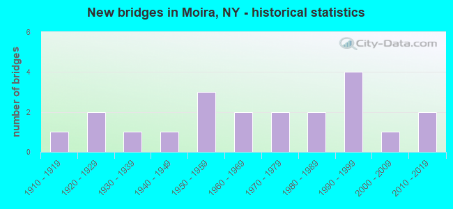
- New bridges - historical statistics
- 11910-1919
- 21920-1929
- 11930-1939
- 11940-1949
- 31950-1959
- 21960-1969
- 21970-1979
- 21980-1989
- 41990-1999
- 12000-2009
- 22010-2019
FCC Registered Cell Phone Towers:
1- (Moira Site) 100 Sr 11 (Lat: 44.823833 Lon: -74.537194), Type: Mast, Structure height: 59.4 m, Overall height: 60.6 m, Call Sign: KNKQ287
Assigned Frequencies: 880.020 MHz, 880.020 MHz, 880.020 MHz, 835.020 MHz, 835.020 MHz, 835.020 MHz, 891.510 MHz, 891.510 MHz, 891.510 MHz, 846.510 MHz, 846.510 MHz, 846.510 MHzGrant Date: 08/31/2021, Expiration Date: 10/01/2031Registrant: Verizon Wireless, 5055 North Point Pkwy, Np2ne Network Engineering, Alpharetta, GA 30022, Phone: (770) 797-1070, Fax: (770) 797-1036, Email:
FCC Registered Broadcast Land Mobile Towers:
1- 250 S Int Cr 5 & Rt 11 On Cr 5 (Lat: 44.818111 Lon: -74.555722), Call Sign: KZJ978, Licensee ID: L00105959,
Assigned Frequencies: 46.3800 MHz, Grant Date: 07/28/2011, Expiration Date: 04/04/2021, Cancellation Date: 06/05/2021, Registrant: Moira Volunteer Fire Rescue Department, 2340 Co Rd S, Moira, NY 12957, Phone: (518) 529-6608
FCC Registered Microwave Towers:
1- MOIRA, 1000 Sr 11 (Lat: 44.823806 Lon: -74.537167), Type: Ltower, Structure height: 60.7 m, Call Sign: WQPA314,
Assigned Frequencies: 5945.20 MHz, Grant Date: 03/19/2012, Expiration Date: 03/19/2022, Cancellation Date: 05/21/2022, Certifier: Chris Harris, Registrant: Conterra Ultra Broadband, LLC, 2101 Rexford Rd, Ste 200e, Charlotte, NC 28211, Phone: (704) 936-1777, Fax: (704) 936-1801, Email:
FCC Registered Amateur Radio Licenses:
12 (See the full list of FCC Registered Amateur Radio Licenses in Moira)FAA Registered Aircraft:
3- Aircraft: TROMBLEY ROGER W VANS RV 8 (Category: Land, Seats: 2, Weight: Up to 12,499 Pounds), Engine: LYCOMING O-320-H2AD (160 HP) (Reciprocating)
N-Number: 594R, N594R, N-594R, Serial Number: 82220, Year manufactured: 2016, Airworthiness Date: 09/28/2016, Certificate Issue Date: 11/03/2017
Registrant (Individual): Scott H Sturgen, 664 Best Rd, Moira, NY 12957 - Aircraft: PIPER J3C-65 (Category: Land, Seats: 2, Weight: Up to 12,499 Pounds, Speed: 67 mph), Engine: CONT MOTOR A&C65 SERIES (65 HP) (Reciprocating)
N-Number: 98504, N98504, N-98504, Serial Number: 18706, Year manufactured: 1946, Airworthiness Date: 01/21/1956, Certificate Issue Date: 05/10/2012
Registrant (Individual): Gerald T Tuper, 294 County Route 32, Moira, NY 12957 - Aircraft: ERCOUPE 415-C (Category: Land, Seats: 2, Weight: Up to 12,499 Pounds, Speed: 90 mph), Engine: CONT MOTOR C85 SERIES (85 HP) (Reciprocating)
N-Number: 99721, N99721, N-99721, Serial Number: 2344, Year manufactured: 1946, Airworthiness Date: 07/04/1956, Certificate Issue Date: 05/24/1966
Registrant (Individual): Edward Joseph Dorey, 872 State Route 11, Moira, NY 12957
| Most common first names in Moira, NY among deceased individuals | ||
| Name | Count | Lived (average) |
|---|---|---|
| William | 9 | 72.9 years |
| Robert | 8 | 72.6 years |
| Joseph | 7 | 71.9 years |
| Raymond | 7 | 68.9 years |
| John | 7 | 75.3 years |
| Kenneth | 7 | 57.1 years |
| Donald | 7 | 65.8 years |
| Grace | 6 | 79.2 years |
| Michael | 6 | 62.0 years |
| Charles | 6 | 76.3 years |
| Most common last names in Moira, NY among deceased individuals | ||
| Last name | Count | Lived (average) |
|---|---|---|
| Russell | 15 | 73.3 years |
| Richards | 9 | 76.8 years |
| Elmer | 8 | 65.4 years |
| Snyder | 7 | 81.0 years |
| Niles | 7 | 71.6 years |
| Parent | 6 | 78.5 years |
| Gale | 5 | 71.0 years |
| Jock | 5 | 61.8 years |
| Finnegan | 5 | 78.2 years |
| Rockhill | 5 | 67.6 years |
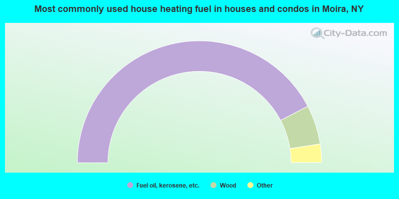
- 84.7%Fuel oil, kerosene, etc.
- 10.4%Wood
- 3.1%Bottled, tank, or LP gas
- 1.3%Electricity
- 0.5%Utility gas
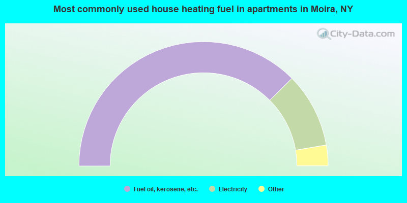
- 75.2%Fuel oil, kerosene, etc.
- 19.5%Electricity
- 2.0%Bottled, tank, or LP gas
- 1.3%Utility gas
- 1.3%Wood
- 0.7%Other fuel
Moira compared to New York state average:
- Median household income below state average.
- Median house value significantly below state average.
- Black race population percentage significantly below state average.
- Hispanic race population percentage significantly below state average.
- Foreign-born population percentage significantly below state average.
- Renting percentage below state average.
- Length of stay since moving in significantly above state average.
- Number of rooms per house significantly below state average.
- House age significantly below state average.
- Number of college students below state average.
- Percentage of population with a bachelor's degree or higher significantly below state average.