Model, Colorado
Submit your own pictures of this place and show them to the world
- OSM Map
- General Map
- Google Map
- MSN Map

| Males: 87 | |
| Females: 96 |
| Median resident age: | 40.9 years |
| Colorado median age: | 34.3 years |
Zip code: 81059
| Model: | $56,277 |
| CO: | $89,302 |
Estimated per capita income in 2022: $29,569 (it was $16,313 in 2000)
Estimated median house or condo value in 2022: $226,945 (it was $90,000 in 2000)
| Model: | $226,945 |
| CO: | $531,100 |
Mean prices in 2022: all housing units: $348,840; detached houses: $375,368; townhouses or other attached units: $332,087; in 2-unit structures: $276,767; in 3-to-4-unit structures: $605,565; mobile homes: $92,938
Detailed information about poverty and poor residents in Model, CO
Compare current foreclosures near your location:
| Photo | Address | Area | Beds / Baths | Price | Details |
|---|---|---|---|---|---|

|
#1
Bayberry Cir
Columbus, OH 43207
|
1,564 sq. feet
|
1 baths 3 beds |
$127,500
|
show details |

|
#2
E 21st Ave
Columbus, OH 43211
|
1,061 sq. feet
|
1 baths 3 beds |
$179,900
|
show details |

|
#3
S High St
Columbus, OH 43207
|
1,678 sq. feet
|
2 baths 4 beds |
$27,500
|
show details |

|
#4
Inishmore Ln
Dublin, OH 43017
|
912 sq. feet
|
1 baths 1 beds |
show details | |

|
#5
Lewis Rd
Columbus, OH 43207
|
1,976 sq. feet
|
2 baths 4 beds |
show details | |

|
#6
Front St
Commercial Point, OH 43116
|
1,311 sq. feet
|
2 baths 3 beds |
show details | |

|
#7
Wallcrest Blvd
Columbus, OH 43231
|
2,152 sq. feet
|
3 baths 3 beds |
show details | |

|
#8
Hall Rd
Galloway, OH 43119
|
1,008 sq. feet
|
1 baths 3 beds |
show details | |

|
#9
Braeburn Ct
Blacklick, OH 43004
|
2,122 sq. feet
|
3 baths 4 beds |
show details | |

|
#10
Elm Ct
Westerville, OH 43082
|
2,022 sq. feet
|
3 baths 4 beds |
show details |
| Photo | Address | Area | Beds / Baths | Price | Details |
|---|---|---|---|---|---|

|
#11
Wallcrest Blvd
Columbus, OH 43231
|
2,236 sq. feet
|
3 baths 4 beds |
show details | |

|
#12
Ironstone Dr
Columbus, OH 43231
|
1,236 sq. feet
|
2 baths 3 beds |
show details | |

|
#13
Hardwood Dr
Galloway, OH 43119
|
2,435 sq. feet
|
3 baths 3 beds |
show details | |

|
#14
Heritage Lakes Dr
Hilliard, OH 43026
|
3,895 sq. feet
|
5 baths 4 beds |
show details | |

|
#15
Andrew Rd
Columbus, OH 43227
|
1,053 sq. feet
|
2 baths 3 beds |
show details | |

|
#16
Golden Cloud Ln
Columbus, OH 43228
|
1,576 sq. feet
|
3 baths 3 beds |
show details | |

|
#17
Alderson Ct
Columbus, OH 43228
|
1,224 sq. feet
|
3 baths 3 beds |
show details | |

|
#18
Doral Ave
Columbus, OH 43213
|
2,124 sq. feet
|
3 baths 4 beds |
show details | |

|
#19
Edgeview Rd
Columbus, OH 43207
|
1,700 sq. feet
|
1 baths 4 beds |
show details | |

|
#20
Firwood Dr
Columbus, OH 43229
|
1,483 sq. feet
|
2 baths 3 beds |
show details |
| Photo | Address | Area | Beds / Baths | Price | Details |
|---|---|---|---|---|---|

|
#21
Baker Hill Rd
Columbus, OH 43207
|
896 sq. feet
|
1 baths 3 beds |
show details | |

|
#22
Minerva Park Pl
Columbus, OH 43229
|
965 sq. feet
|
3 baths 3 beds |
show details | |

|
#23
Big Walnut Dr
Groveport, OH 43125
|
1,028 sq. feet
|
1 baths 3 beds |
show details | |

|
#24
Sweeny Ct
Dublin, OH 43017
|
2,160 sq. feet
|
3 baths 4 beds |
show details | |

|
#25
Lovell Ln
Blacklick, OH 43004
|
1,920 sq. feet
|
3 baths 3 beds |
show details | |

|
#26
Sandalwood Blvd
Columbus, OH 43229
|
1,161 sq. feet
|
2 baths 3 beds |
show details | |

|
#27
Hempwood Dr
Columbus, OH 43229
|
1,360 sq. feet
|
2 baths 3 beds |
show details | |

|
#28
Westrock Dr
Hilliard, OH 43026
|
1,819 sq. feet
|
3 baths 3 beds |
show details | |

|
#29
Steiner St
Columbus, OH 43231
|
1,464 sq. feet
|
3 baths 3 beds |
show details | |

|
#30
Dunkirk Dr
Columbus, OH 43219
|
924 sq. feet
|
1 baths 3 beds |
show details |
| Photo | Address | Area | Beds / Baths | Price | Details |
|---|---|---|---|---|---|

|
#31
Richardson Rd
Groveport, OH 43125
|
1,080 sq. feet
|
3 baths 4 beds |
show details | |

|
#32
Parkwood Ave
Columbus, OH 43211
|
672 sq. feet
|
1 baths 2 beds |
show details | |

|
#33
Brookview Cir
Pickerington, OH 43147
|
1,280 sq. feet
|
3 baths 2 beds |
show details | |

|
#34
Chinquo St
Grove City, OH 43123
|
1,158 sq. feet
|
2 baths 3 beds |
show details | |

|
#35
N Dawson Ave
Columbus, OH 43219
|
888 sq. feet
|
2 baths 3 beds |
show details | |

|
#36
Scriven Ave
Columbus, OH 43228
|
832 sq. feet
|
2 baths 2 beds |
show details | |

|
#37
Silo Ct
Hilliard, OH 43026
|
2,865 sq. feet
|
4 baths 4 beds |
show details | |

|
#38
Muldoon Ct
Dublin, OH 43016
|
1,816 sq. feet
|
3 baths 3 beds |
show details | |

|
#39
Brookfield Rd
Columbus, OH 43229
|
924 sq. feet
|
1 baths 3 beds |
show details | |

|
#40
Wynnewood Dr
Grove City, OH 43123
|
3,170 sq. feet
|
3 baths 4 beds |
show details |
| Photo | Address | Area | Beds / Baths | Price | Details |
|---|---|---|---|---|---|

|
#41
Dover Rd
Columbus, OH 43209
|
2,019 sq. feet
|
3 baths 3 beds |
show details | |

|
#42
Oakland Park Ave
Columbus, OH 43224
|
1,127 sq. feet
|
1 baths 3 beds |
show details | |

|
#43
Hepplewhite St
Westerville, OH 43081
|
1,570 sq. feet
|
3 baths 4 beds |
show details | |

|
#44
Black Kettle Trl
Dublin, OH 43017
|
1,768 sq. feet
|
3 baths 4 beds |
show details | |

|
#45
Maplerun Ln
Westerville, OH 43081
|
2,020 sq. feet
|
3 baths 4 beds |
show details | |

|
#46
Norman Dr
Columbus, OH 43227
|
1,260 sq. feet
|
2 baths 3 beds |
show details | |

|
#47
Prosperity Ln
Columbus, OH 43231
|
1,376 sq. feet
|
3 baths 3 beds |
show details | |

|
#48
Alkire Rd
Grove City, OH 43123
|
1,680 sq. feet
|
3 baths 4 beds |
show details | |

|
#49
Bar Harbor Rd
Columbus, OH 43219
|
960 sq. feet
|
2 baths 3 beds |
show details | |

|
Check over 1 million property listings on Foreclosure.com!
|
browse all offers | |||

- 14280.2%White alone
- 179.6%Hispanic
- 105.6%Two or more races
- 42.3%American Indian alone
- 21.1%Black alone
- 21.1%Asian alone

 Recent articles from our blog. Our writers, many of them Ph.D. graduates or candidates, create easy-to-read articles on a wide variety of topics.
Current Local Time: MST time zone
Elevation: 5611 feet
Land area: 938.4 square miles.
Population density: 0.2 people per square mile (very low).

| Model CCD: | 1.4% ($1,250) |
| Colorado: | 0.7% ($1,132) |
Nearest city with pop. 50,000+: Pueblo, CO  (68.2 miles , pop. 102,121).
Nearest city with pop. 200,000+: Colorado Springs, CO (109.8 miles , pop. 360,890).
Nearest city with pop. 1,000,000+: Dallas, TX (520.2 miles , pop. 1,188,580).
Nearest cities:
), Latitude: 37.38 N, Longitude: 104.09 W
Area code commonly used in this area: 719


| Here: | 5.1% |
| Colorado: | 3.2% |

- Agriculture, forestry, fishing & hunting (21.9%)
- Educational services (18.8%)
- Accommodation & food services (14.1%)
- Construction (7.8%)
- Utilities (7.8%)
- Machinery (4.7%)
- Health care (4.7%)

- Agriculture, forestry, fishing & hunting (36.8%)
- Construction (13.2%)
- Utilities (13.2%)
- Machinery (7.9%)
- Accommodation & food services (7.9%)
- Nonmetallic mineral products (5.3%)
- Transportation equipment (5.3%)

- Educational services (46.2%)
- Accommodation & food services (23.1%)
- Building material & garden equipment & supplies dealers (7.7%)
- Health care (7.7%)
- Social assistance (7.7%)
- Personal & laundry services (7.7%)

- Farmers and farm managers (17.2%)
- Preschool, kindergarten, elementary, and middle school teachers (10.9%)
- Engineers (7.8%)
- Other construction workers and helpers (4.7%)
- Agricultural workers, including supervisors (4.7%)
- Postsecondary teachers (4.7%)
- Child care workers (4.7%)

- Farmers and farm managers (28.9%)
- Engineers (13.2%)
- Child care workers (7.9%)
- Agricultural workers, including supervisors (7.9%)
- Other construction workers and helpers (7.9%)
- Metal workers and plastic workers (7.9%)
- Material recording, scheduling, dispatching, and distributing workers (5.3%)

- Preschool, kindergarten, elementary, and middle school teachers (26.9%)
- Postsecondary teachers (11.5%)
- Nursing, psychiatric, and home health aides (7.7%)
- Teachers, secondary school (7.7%)
- Personal appearance workers (7.7%)
- Waiters and waitresses (7.7%)
- Building and grounds cleaning and maintenance occupations (7.7%)
Average climate in Model, Colorado
Based on data reported by over 4,000 weather stations


Tornado activity:
Model-area historical tornado activity is significantly below Colorado state average. It is 80% smaller than the overall U.S. average.
On 7/10/1978, a category F2 (max. wind speeds 113-157 mph) tornado 19.1 miles away from the Model place center injured 2 people and caused between $5000 and $50,000 in damages.
On 5/29/1964, a category F3 (max. wind speeds 158-206 mph) tornado 64.0 miles away from the place center killed one person and injured 8 people and caused between $50,000 and $500,000 in damages.
Earthquake activity:
Model-area historical earthquake activity is significantly above Colorado state average. It is 667% greater than the overall U.S. average.On 8/23/2011 at 05:46:18, a magnitude 5.3 (5.3 MW, Depth: 2.5 mi, Class: Moderate, Intensity: VI - VII) earthquake occurred 40.1 miles away from Model center
On 8/10/2005 at 22:08:22, a magnitude 5.0 (5.0 MB, 4.7 MS, 5.0 MW) earthquake occurred 49.0 miles away from Model center
On 8/10/2005 at 22:08:22, a magnitude 5.0 (5.0 MW, Depth: 3.1 mi) earthquake occurred 50.7 miles away from Model center
On 8/22/2011 at 23:30:19, a magnitude 4.7 (4.7 MW, Depth: 3.1 mi, Class: Light, Intensity: IV - V) earthquake occurred 35.0 miles away from Model center
On 8/18/1959 at 06:37:13, a magnitude 7.7 (7.7 UK, Class: Major, Intensity: VIII - XII) earthquake occurred 603.7 miles away from Model center, causing $26,000,000 total damage
On 9/5/2001 at 10:52:07, a magnitude 4.5 (4.5 MB, Depth: 3.1 mi) earthquake occurred 33.4 miles away from the city center
Magnitude types: body-wave magnitude (MB), surface-wave magnitude (MS), moment magnitude (MW)
Natural disasters:
The number of natural disasters in Las Animas County (12) is smaller than the US average (15).Major Disasters (Presidential) Declared: 3
Emergencies Declared: 5
Causes of natural disasters: Fires: 4, Floods: 2, Snows: 2, Storms: 2, Drought: 1, Hurricane: 1, Landslide: 1, Mudslide: 1, Snowstorm: 1, Tornado: 1, Other: 1 (Note: some incidents may be assigned to more than one category).
Colleges/universities with over 2000 students nearest to Model:
- Pueblo Community College (about 69 miles; Pueblo, CO; Full-time enrollment: 5,329)
- Colorado State University-Pueblo (about 70 miles; Pueblo, CO; FT enrollment: 5,993)
- Adams State University (about 99 miles; Alamosa, CO; FT enrollment: 2,805)
- Pikes Peak Community College (about 104 miles; Colorado Springs, CO; FT enrollment: 10,395)
- Colorado College (about 110 miles; Colorado Springs, CO; FT enrollment: 2,199)
- University of Colorado Colorado Springs (about 112 miles; Colorado Springs, CO; FT enrollment: 8,700)
- Colorado Technical University-Online (about 113 miles; Colorado Springs, CO; FT enrollment: 22,771)
Points of interest:
Notable locations in Model: East Windmill (A), Lower Windmill (B), Burr Windmill (C), Rock Crossing (D), Thatcher (E), Deal Windmill (F), Hall Windmill (G), Vega Corral (H), West Fork Long Branch (I), Hixson Windmill (J), Hidden Valley Ranch (K), Rourke Ranch (L), Barbee Windmill (M), J B Windmill (N), Corner Windmill (O), Double Tank Windmill (P), Ahern Windmill (Q), West Pasture Windmill (R), Pool Windmill (S), Sutton Windmill (T). Display/hide their locations on the map
Cemeteries: Wilcox Cemetery (1), Mestas Cemetery (2), Simpson Cemetery (3). Display/hide their locations on the map
Lakes and reservoirs: Browns Lake (A), Simpson Lake (B), Twin Lakes (C), Bates Lake (D), Perky Reservoir (E), Big Reservoir (F), Rourke Reservoir (G), Smith Pond (H). Display/hide their locations on the map
Streams, rivers, and creeks: Big Water Arroyo (A), Chacuaco Creek (B), Lockwood Arroyo (C), Big Arroyo (D), Middle Bear Springs Arroyo (E), Blackwell Arroyo (F), Furness Arroyo (G), Taylor Arroyo (H), Burke Arroyo (I). Display/hide their locations on the map
| This place: | 2.3 people |
| Colorado: | 2.5 people |
| This place: | 70.6% |
| Whole state: | 63.9% |
| This place: | 1.5% |
| Whole state: | 6.5% |
No gay or lesbian households reported
| This place: | 9.8% |
| Whole state: | 9.3% |
| This place: | 4.9% |
| Whole state: | 4.1% |
For population 15 years and over in Model:

- Never married: 13.0%
- Now married: 68.3%
- Separated: 2.4%
- Widowed: 9.8%
- Divorced: 8.9%
For population 25 years and over in Model:
- High school or higher: 83.3%
- Bachelor's degree or higher: 16.7%
- Graduate or professional degree: 0.0%
- Unemployed: 5.9%
- Mean travel time to work (commute): 38.0 minutes


| Here: | 8.5 |
| Colorado average: | 11.8 |
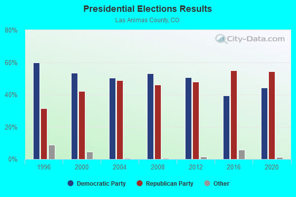
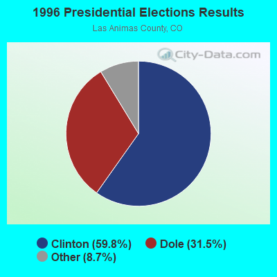
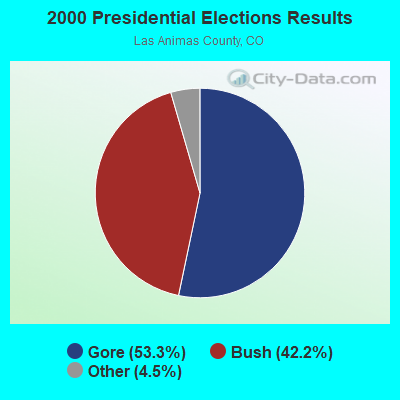
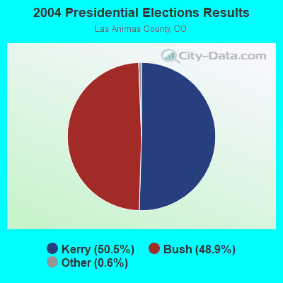
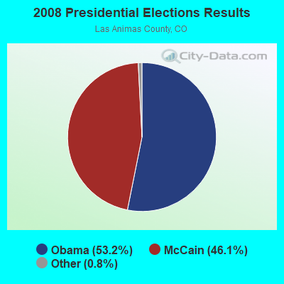

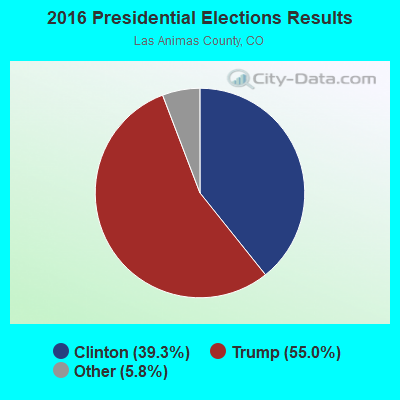
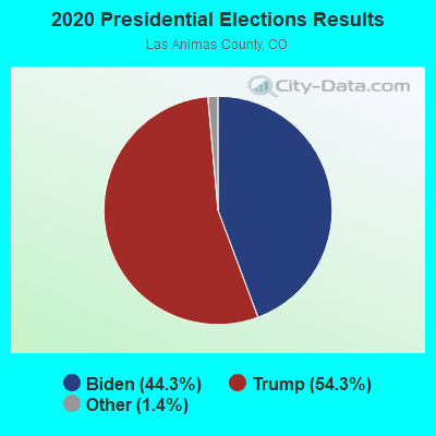
Graphs represent county-level data. Detailed 2008 Election Results
Religion statistics for Model, CO (based on Las Animas County data)
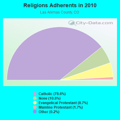
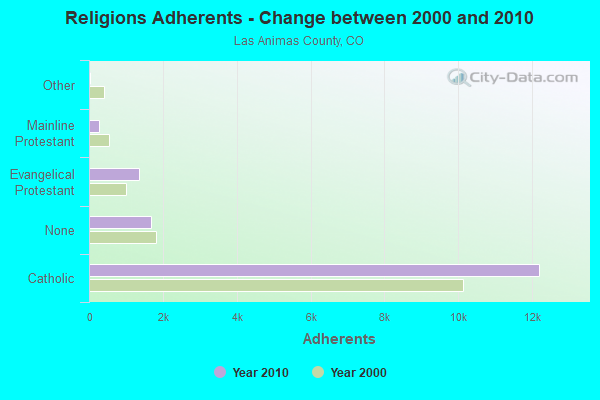
| Religion | Adherents | Congregations |
|---|---|---|
| Catholic | 12,196 | 4 |
| Evangelical Protestant | 1,343 | 13 |
| Mainline Protestant | 258 | 3 |
| Other | 32 | 2 |
| None | 1,678 | - |
Food Environment Statistics:
| Las Animas County: | 3.14 / 10,000 pop. |
| Colorado: | 1.50 / 10,000 pop. |
| This county: | 0.63 / 10,000 pop. |
| Colorado: | 0.15 / 10,000 pop. |
| This county: | 1.25 / 10,000 pop. |
| Colorado: | 0.45 / 10,000 pop. |
| Here: | 3.76 / 10,000 pop. |
| Colorado: | 3.13 / 10,000 pop. |
| Las Animas County: | 11.29 / 10,000 pop. |
| Colorado: | 8.99 / 10,000 pop. |
| Las Animas County: | 6.6% |
| Colorado: | 5.3% |
| Las Animas County: | 20.7% |
| Colorado: | 18.4% |
| Las Animas County: | 10.3% |
| State: | 9.6% |
Strongest AM radio stations in Model:
- KKOB (770 AM; 50 kW; ALBUQUERQUE, NM; Owner: CITADEL BROADCASTING COMPANY)
- KOA (850 AM; 50 kW; DENVER, CO; Owner: JACOR BROADCASTING OF COLORADO, INC.)
- KLTT (670 AM; 50 kW; COMMERCE CITY, CO; Owner: KLZ RADIO, INC.)
- KKZN (760 AM; 50 kW; THORNTON, CO; Owner: JACOR BROADCASTING OF COLORADO, INC.)
- KMXA (1090 AM; 50 kW; AURORA, CO; Owner: ENTRAVISION HOLDINGS, LLC)
- KGYN (1210 AM; 50 kW; GUYMON, OK; Owner: TELNS BROADCASTING COMPANY, INC.)
- KCBR (1040 AM; daytime; 15 kW; MONUMENT, CO; Owner: KLZ RADIO, INC.)
- KICA (980 AM; 50 kW; CLOVIS, NM; Owner: BROADCAST ENTERTAINMENT CORPORATION)
- KCMN (1530 AM; 15 kW; COLORADO SPRINGS, CO)
- KMUL (1380 AM; 50 kW; MULESHOE, TX; Owner: BROADCAST ENTERTAINMENT CORPORATION)
- KTNN (660 AM; 50 kW; WINDOW ROCK, AZ; Owner: THE NAVAJO NATION)
- KGHF (1350 AM; 5 kW; PUEBLO, CO; Owner: CLEAR CHANNEL BROADCASTING LICENSES, INC.)
- KLMO (1060 AM; 30 kW; LONGMONT, CO; Owner: PILGRIM COMMUNICATIONS, INC.)
Strongest FM radio stations in Model:
- KCRT-FM (92.5 FM; TRINIDAD, CO; Owner: PHILLIPS BROADCASTING, INC.)
- K207BN (89.3 FM; TRINIDAD, CO; Owner: MAKE A DIFFERENCE FOUNDATION, INC.)
- KBKZ (96.5 FM; RATON, NM; Owner: PHILLIPS BROADCASTING COMPANY, INC.)
- KDZA-FM (107.9 FM; PUEBLO, CO; Owner: CAPSTAR TX LIMITED PARTNERSHIP)
- KRTN-FM (93.9 FM; RATON, NM; Owner: RATON BROADCASTING COMPANY)
FCC Registered Cell Phone Towers:
2 (See the full list of FCC Registered Cell Phone Towers in Model)FCC Registered Antenna Towers:
7 (See the full list of FCC Registered Antenna Towers)FCC Registered Microwave Towers:
2- MODEL, 485251 Cr 52 (Lat: 37.367028 Lon: -104.266139), Type: Ltower, Structure height: 76.2 m, Overall height: 79.2 m, Call Sign: WQQD408,
Assigned Frequencies: 6004.50 MHz, Grant Date: 10/04/2022, Expiration Date: 11/06/2032, Certifier: Gregory M Romano, Registrant: Verizon, 5055 Northpointe Pkwy, Alpharetta, GA 30022, Phone: (770) 797-1070, Email:
- BUSCH RANCH, Colorado 10 (Lat: 37.774306 Lon: -104.406444), Type: Ltower, Structure height: 92.1 m, Overall height: 94.5 m, Call Sign: WQZG476,
Assigned Frequencies: 6815.00 MHz, Grant Date: 05/09/2017, Expiration Date: 05/09/2027, Certifier: Dave Cundiff, Registrant: At&t Services, Inc., 208 S Akard St, 20f, Dallas, TX 75202, Phone: (855) 699-7073, Fax: (972) 907-1131, Email:
FCC Registered Amateur Radio Licenses:
1- Call Sign: N0NFI, Previous Call Sign: N0LWM, Licensee ID: L00310197, Grant Date: 07/12/2011, Expiration Date: 07/12/2021, Cancellation Date: 07/13/2023, Registrant: Robert S Bounds, 41097 Co Rd 121.0, Model, CO 81059
FAA Registered Aircraft:
1- Aircraft: CESSNA 320D (Category: Land, Engines: 2, Seats: 6, Weight: Up to 12,499 Pounds, Speed: 183 mph), Engine: CONT MOTOR TSIO-520 SER (300 HP) (Reciprocating)
N-Number: 558S, N558S, N-558S, Serial Number: 320D0099, Year manufactured: 1966, Airworthiness Date: 02/08/1966, Certificate Issue Date: 12/16/2019
Registrant (Individual): Linda D Bounds, 41097 County Road 121.0, Model, CO 81059

- 72.2%Bottled, tank, or LP gas
- 16.7%Wood
- 7.4%Utility gas
- 3.7%Electricity

- 50.0%Utility gas
- 50.0%Bottled, tank, or LP gas
Model compared to Colorado state average:
- Median household income below state average.
- Median house value significantly below state average.
- Unemployed percentage below state average.
- Black race population percentage significantly below state average.
- Hispanic race population percentage below state average.
- Foreign-born population percentage significantly below state average.
- Renting percentage below state average.
- Length of stay since moving in significantly above state average.
- Number of rooms per house significantly below state average.
- House age significantly below state average.
- Institutionalized population percentage significantly above state average.
- Percentage of population with a bachelor's degree or higher below state average.