Mina, New York
Submit your own pictures of this town and show them to the world
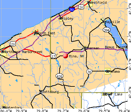
- OSM Map
- General Map
- Google Map
- MSN Map
Population change since 2000: -6.0%
 |
| Males: 547 | |
| Females: 559 |
| Median resident age: | 42.5 years |
| New York median age: | 40.7 years |
Zip codes: 14781.
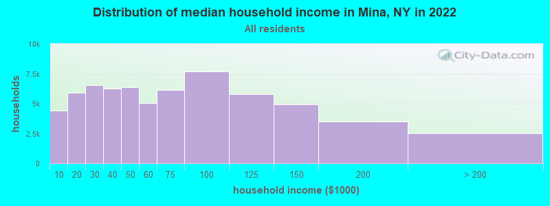
| Mina: | $66,531 |
| NY: | $79,557 |
Estimated per capita income in 2022: $34,807 (it was $18,240 in 2000)
Mina town income, earnings, and wages data
Estimated median house or condo value in 2022: $153,955 (it was $78,800 in 2000)
| Mina: | $153,955 |
| NY: | $400,400 |
Mean prices in 2022: all housing units: $168,876; detached houses: $173,869; townhouses or other attached units: $92,544; in 2-unit structures: $200,826; in 3-to-4-unit structures: $86,545; in 5-or-more-unit structures: $466,469; mobile homes: $70,313
Detailed information about poverty and poor residents in Mina, NY


- 1,07897.5%White alone
- 151.4%Two or more races
- 80.7%Hispanic
- 50.5%Asian alone
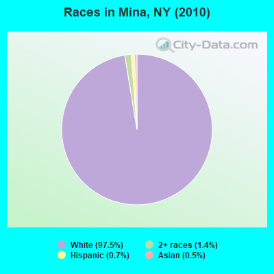
Races in Mina detailed stats: ancestries, foreign born residents, place of birth
 Recent articles from our blog. Our writers, many of them Ph.D. graduates or candidates, create easy-to-read articles on a wide variety of topics.

 | NYS passes new strict gun laws (92 replies) |
| Events in Syracuse? (1135 replies) |
| 9-Day Waits for N.Y.C. COVID tests + A new cheap and simple test (10 replies) |
| Sherman - Mina <Chautauqua> Building Question (0 replies) |
| Visiting NYC for the first time! (14 replies) |
| Dunkirk or Fredonia NY (90 replies) |
Latest news from Mina, NY collected exclusively by city-data.com from local newspapers, TV, and radio stations
Ancestries: German (25.9%), English (18.0%), Irish (13.6%), Polish (8.5%), United States (8.0%), Dutch (7.7%).
Current Local Time: EST time zone
Elevation: 1598 feet
Land area: 35.9 square miles.
Population density: 31 people per square mile (very low).
7 residents are foreign born
| This town: | 0.6% |
| New York: | 20.4% |
| Mina town: | 2.3% ($1,780) |
| New York: | 1.9% ($2,847) |
Nearest city with pop. 50,000+: Erie, PA  (19.1 miles , pop. 103,717).
Nearest city with pop. 200,000+: Buffalo, NY (69.0 miles , pop. 292,648).
Nearest city with pop. 1,000,000+: Philadelphia, PA (279.9 miles , pop. 1,517,550).
Nearest cities:
Latitude: 42.13 N, Longitude: 79.71 W
Area code commonly used in this area: 716

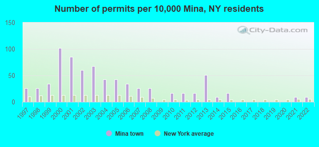
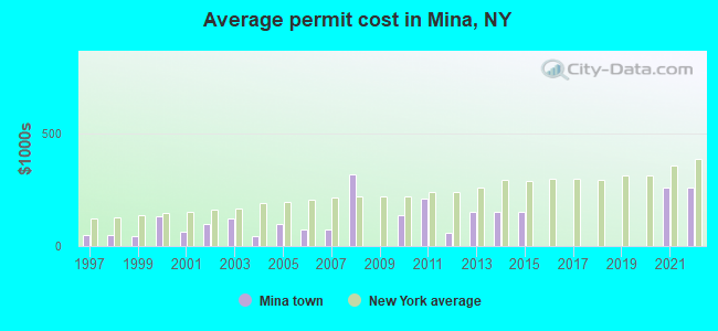
Single-family new house construction building permits:
- 2022: 1 building, cost: $259,200
- 2021: 1 building, cost: $259,200
- 2015: 2 buildings, average cost: $150,500
- 2014: 1 building, cost: $150,500
- 2013: 6 buildings, average cost: $150,500
- 2012: 2 buildings, average cost: $58,000
- 2011: 2 buildings, average cost: $207,500
- 2010: 2 buildings, average cost: $137,500
- 2008: 3 buildings, average cost: $316,700
- 2007: 3 buildings, average cost: $72,500
- 2006: 4 buildings, average cost: $72,500
- 2005: 5 buildings, average cost: $98,000
- 2004: 5 buildings, average cost: $46,000
- 2003: 8 buildings, average cost: $124,000
- 2002: 7 buildings, average cost: $99,000
- 2001: 10 buildings, average cost: $63,000
- 2000: 12 buildings, average cost: $129,600
- 1999: 4 buildings, average cost: $44,300
- 1998: 3 buildings, average cost: $47,200
- 1997: 3 buildings, average cost: $47,200
| Here: | 4.8% |
| New York: | 4.4% |
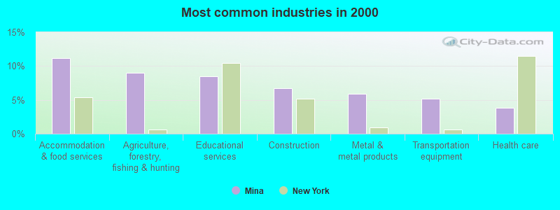
- Accommodation & food services (11.2%)
- Agriculture, forestry, fishing & hunting (9.0%)
- Educational services (8.4%)
- Construction (6.7%)
- Metal & metal products (5.9%)
- Transportation equipment (5.2%)
- Health care (3.8%)
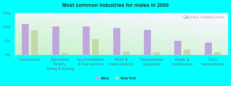
- Construction (11.2%)
- Agriculture, forestry, fishing & hunting (10.3%)
- Accommodation & food services (10.3%)
- Metal & metal products (9.7%)
- Transportation equipment (9.1%)
- Repair & maintenance (5.2%)
- Truck transportation (4.6%)
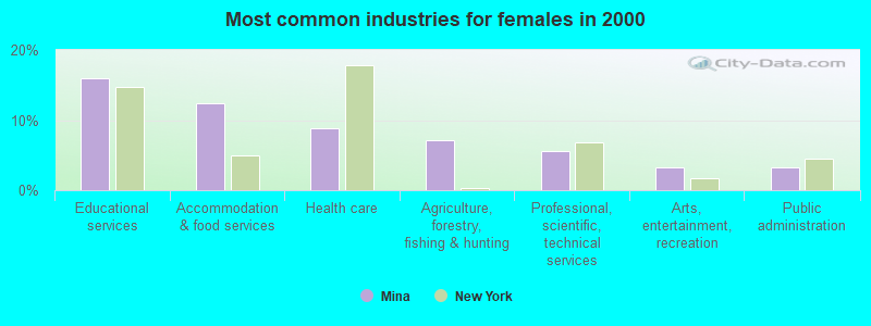
- Educational services (15.9%)
- Accommodation & food services (12.4%)
- Health care (8.8%)
- Agriculture, forestry, fishing & hunting (7.2%)
- Professional, scientific, technical services (5.6%)
- Arts, entertainment, recreation (3.2%)
- Public administration (3.2%)
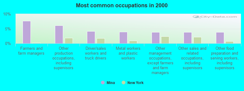
- Farmers and farm managers (7.6%)
- Other production occupations, including supervisors (6.0%)
- Driver/sales workers and truck drivers (4.1%)
- Metal workers and plastic workers (4.0%)
- Other management occupations, except farmers and farm managers (3.8%)
- Other sales and related occupations, including supervisors (3.8%)
- Other food preparation and serving workers, including supervisors (3.8%)

- Farmers and farm managers (8.8%)
- Other production occupations, including supervisors (7.6%)
- Driver/sales workers and truck drivers (6.7%)
- Metal workers and plastic workers (6.4%)
- Vehicle and mobile equipment mechanics, installers, and repairers (5.2%)
- Other food preparation and serving workers, including supervisors (4.6%)
- Other management occupations, except farmers and farm managers (4.6%)

- Secretaries and administrative assistants (8.4%)
- Farmers and farm managers (6.0%)
- Other sales and related occupations, including supervisors (5.2%)
- Information and record clerks, except customer service representatives (5.2%)
- Other office and administrative support workers, including supervisors (4.4%)
- Cooks and food preparation workers (4.4%)
- Preschool, kindergarten, elementary, and middle school teachers (4.0%)
Average climate in Mina, New York
Based on data reported by over 4,000 weather stations


(lower is better)
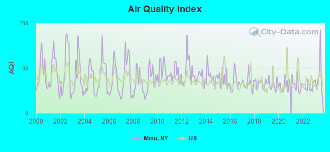
Air Quality Index (AQI) level in 2023 was 81.2. This is about average.
| City: | 81.2 |
| U.S.: | 72.6 |
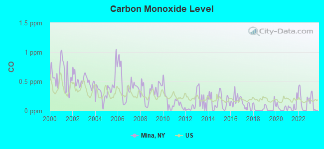
Carbon Monoxide (CO) [ppm] level in 2023 was 0.120. This is significantly better than average. Closest monitor was 17.1 miles away from the city center.
| City: | 0.120 |
| U.S.: | 0.251 |
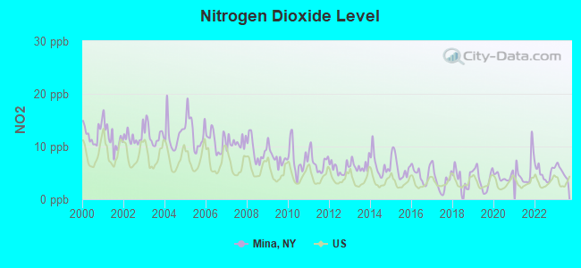
Nitrogen Dioxide (NO2) [ppb] level in 2023 was 5.31. This is about average. Closest monitor was 17.1 miles away from the city center.
| City: | 5.31 |
| U.S.: | 5.11 |

Sulfur Dioxide (SO2) [ppb] level in 2012 was 0.972. This is significantly better than average. Closest monitor was 12.5 miles away from the city center.
| City: | 0.972 |
| U.S.: | 1.515 |
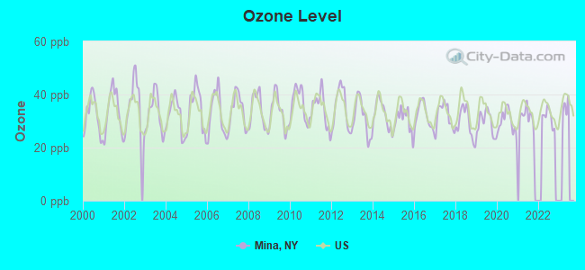
Ozone [ppb] level in 2022 was 31.5. This is about average. Closest monitor was 12.5 miles away from the city center.
| City: | 31.5 |
| U.S.: | 33.3 |
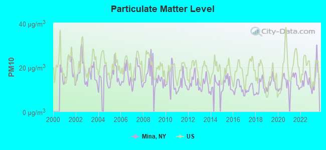
Particulate Matter (PM10) [µg/m3] level in 2023 was 15.9. This is better than average. Closest monitor was 12.5 miles away from the city center.
| City: | 15.9 |
| U.S.: | 19.2 |
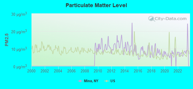
Particulate Matter (PM2.5) [µg/m3] level in 2023 was 11.1. This is worse than average. Closest monitor was 12.5 miles away from the city center.
| City: | 11.1 |
| U.S.: | 8.1 |
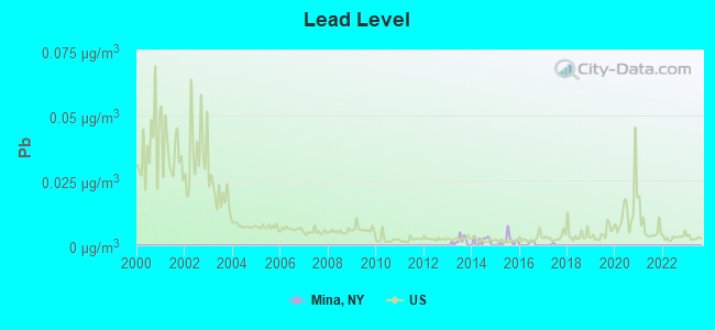
Lead (Pb) [µg/m3] level in 2016 was 0.00043. This is significantly better than average. Closest monitor was 17.2 miles away from the city center.
| City: | 0.00043 |
| U.S.: | 0.00931 |
Tornado activity:
Mina-area historical tornado activity is above New York state average. It is 39% smaller than the overall U.S. average.
On 5/31/1985, a category F4 (max. wind speeds 207-260 mph) tornado 15.2 miles away from the Mina town center .
On 5/2/1983, a category F3 (max. wind speeds 158-206 mph) tornado 4.5 miles away from the town center killed 2 people and caused between $500,000 and $5,000,000 in damages.
Earthquake activity:
Mina-area historical earthquake activity is significantly above New York state average. It is 64% smaller than the overall U.S. average.On 9/25/1998 at 19:52:52, a magnitude 5.2 (4.8 MB, 4.3 MS, 5.2 LG, 4.5 MW, Depth: 3.1 mi, Class: Moderate, Intensity: VI - VII) earthquake occurred 56.9 miles away from the city center
On 1/31/1986 at 16:46:43, a magnitude 5.0 (5.0 MB) earthquake occurred 83.4 miles away from Mina center
On 8/23/2011 at 17:51:04, a magnitude 5.8 (5.8 MW, Depth: 3.7 mi) earthquake occurred 306.7 miles away from Mina center
On 10/7/1983 at 10:18:46, a magnitude 5.3 (5.1 MB, 5.3 LG, 5.1 ML) earthquake occurred 298.9 miles away from Mina center
On 1/26/2001 at 03:03:20, a magnitude 3.9 (3.9 MB, Depth: 3.1 mi, Class: Light, Intensity: II - III) earthquake occurred 57.9 miles away from the city center
On 12/31/2011 at 20:05:01, a magnitude 4.0 (4.0 ML, Depth: 3.1 mi, Class: Light, Intensity: IV - V) earthquake occurred 86.3 miles away from Mina center
Magnitude types: regional Lg-wave magnitude (LG), body-wave magnitude (MB), local magnitude (ML), surface-wave magnitude (MS), moment magnitude (MW)
Natural disasters:
The number of natural disasters in Chautauqua County (21) is greater than the US average (15).Major Disasters (Presidential) Declared: 11
Emergencies Declared: 9
Causes of natural disasters: Floods: 9, Storms: 9, Snowstorms: 4, Hurricanes: 2, Winter Storms: 2, Blizzard: 1, Ice Storm: 1, Power Outage: 1, Snow: 1, Tropical Storm: 1, Wind: 1, Other: 2 (Note: some incidents may be assigned to more than one category).
Hospitals and medical centers near Mina:
- COMMUNITY NURSING NORTH EAST (Home Health Center, about 9 miles away; NORTH EAST, PA)
- HOSPICE CHAUTAUQUA COUNTY INC (Hospital, about 13 miles away; MAYVILLE, NY)
- CORRY REGIONAL HOSPICE (Hospital, about 15 miles away; CORRY, PA)
- CORRY MANOR (Nursing Home, about 15 miles away; CORRY, PA)
- DAVITA - CORRY DIALYSIS (Dialysis Facility, about 15 miles away; CORRY, PA)
- BALL PAVILION, THE (Nursing Home, about 16 miles away; ERIE, PA)
- ABSOLUT CTR FOR NURSING AND REHAB WESTFIELD L L C (Nursing Home, about 16 miles away; WESTFIELD, NY)
Colleges/universities with over 2000 students nearest to Mina:
- Pennsylvania State University-Penn State Erie-Behrend College (about 15 miles; Erie, PA; Full-time enrollment: 4,025)
- Mercyhurst University (about 19 miles; Erie, PA; FT enrollment: 2,888)
- Gannon University (about 20 miles; Erie, PA; FT enrollment: 3,760)
- Jamestown Community College (about 25 miles; Jamestown, NY; FT enrollment: 3,384)
- Edinboro University of Pennsylvania (about 29 miles; Edinboro, PA; FT enrollment: 6,746)
- SUNY at Fredonia (about 30 miles; Fredonia, NY; FT enrollment: 5,523)
- Allegheny College (about 41 miles; Meadville, PA; FT enrollment: 2,249)
Points of interest:
Notable locations in Mina: Paradise Bay Park (A), Camp Findley (B), Alexander Findley Community Library (C), Findlay Lake Volunteer Fire Department (D). Display/hide their locations on the map
Churches in Mina include: Christian Missionary Alliance Church (A), Findley Lake United Methodist Church (B). Display/hide their locations on the map
Cemeteries: Mina Cemetery (1), Marks Corners Cemetery (2), Findley Lake Cemetery (3), West Mina Cemetery (4). Display/hide their locations on the map
Lakes and swamps: Findley Lake (A), Beaver Marsh (B). Display/hide their locations on the map
Streams, rivers, and creeks: Parks Brook (A). Display/hide its location on the map
| This town: | 2.7 people |
| New York: | 2.6 people |
| This town: | 76.8% |
| Whole state: | 63.5% |
| This town: | 6.5% |
| Whole state: | 6.8% |
Likely homosexual households (counted as self-reported same-sex unmarried-partner households)
- Lesbian couples: 0.2% of all households
- Gay men: 0.2% of all households
| This town: | 9.3% |
| Whole state: | 14.6% |
| This town: | 6.3% |
| Whole state: | 7.4% |
For population 15 years and over in Mina:
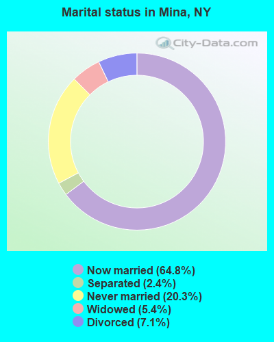
- Never married: 20.3%
- Now married: 64.8%
- Separated: 2.4%
- Widowed: 5.4%
- Divorced: 7.1%
For population 25 years and over in Mina:
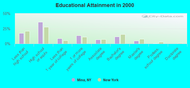
- High school or higher: 82.3%
- Bachelor's degree or higher: 17.4%
- Graduate or professional degree: 5.6%
- Unemployed: 5.4%
- Mean travel time to work (commute): 20.2 minutes
| Here: | 9.9 |
| New York average: | 14.2 |
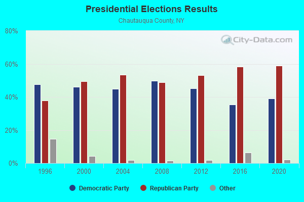
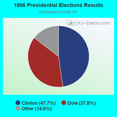
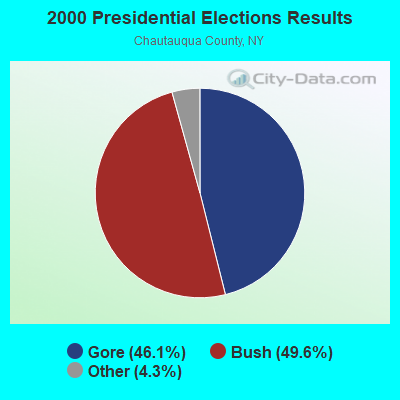


Graphs represent county-level data. Detailed 2008 Election Results
Religion statistics for Mina, NY (based on Chautauqua County data)
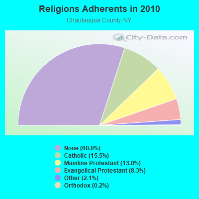
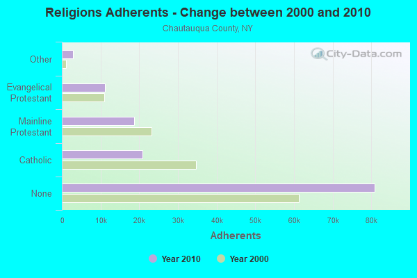
| Religion | Adherents | Congregations |
|---|---|---|
| Catholic | 20,912 | 13 |
| Mainline Protestant | 18,659 | 86 |
| Evangelical Protestant | 11,175 | 105 |
| Other | 2,884 | 19 |
| Orthodox | 230 | 2 |
| Black Protestant | 120 | 1 |
| None | 80,925 | - |
Food Environment Statistics:
| This county: | 2.76 / 10,000 pop. |
| State: | 4.13 / 10,000 pop. |
| Chautauqua County: | 0.07 / 10,000 pop. |
| New York: | 0.06 / 10,000 pop. |
| Here: | 1.12 / 10,000 pop. |
| New York: | 0.92 / 10,000 pop. |
| This county: | 3.06 / 10,000 pop. |
| State: | 1.68 / 10,000 pop. |
| Chautauqua County: | 11.05 / 10,000 pop. |
| New York: | 8.82 / 10,000 pop. |
| Here: | 8.1% |
| New York: | 8.2% |
| This county: | 29.3% |
| New York: | 23.8% |
| Chautauqua County: | 12.4% |
| New York: | 15.6% |
Strongest AM radio stations in Mina:
- WRIE (1260 AM; 5 kW; ERIE, PA; Owner: REGENT LICENSEE OF ERIE, INC.)
- WFNN (1330 AM; 5 kW; ERIE, PA; Owner: NM LICENSING, LLC)
- WWKB (1520 AM; 50 kW; BUFFALO, NY; Owner: ENTERCOM BUFFALO LICENSE, LLC)
- WEYZ (1530 AM; daytime; 1 kW; NORTH EAST, PA)
- WKNR (850 AM; 50 kW; CLEVELAND, OH; Owner: CARON BROADCASTING, INC.)
- KDKA (1020 AM; 50 kW; PITTSBURGH, PA; Owner: INFINITY BROADCASTING OPERATIONS, INC.)
- WWCB (1370 AM; 1 kW; CORRY, PA; Owner: CORRY COMMUNICATIONS CORPORATION)
- WTAM (1100 AM; 50 kW; CLEVELAND, OH; Owner: JACOR BROADCASTING CORPORATION)
- WNAE (1310 AM; 5 kW; WARREN, PA; Owner: KINZUA BROADCASTING COMPANY)
- WHK (1220 AM; 50 kW; CLEVELAND, OH; Owner: CARON BROADCASTING, INC.)
- WHAM (1180 AM; 50 kW; ROCHESTER, NY; Owner: CITICASTERS LICENSES, L.P.)
- WPSE (1450 AM; 1 kW; ERIE, PA; Owner: THE BOARD OF TRUSTEES OF PA STATE UN)
- WGR (550 AM; 5 kW; BUFFALO, NY; Owner: ENTERCOM BUFFALO LICENSE, LLC)
Strongest FM radio stations in Mina:
- WRKT (100.9 FM; NORTH EAST, PA; Owner: NM LICENSING, LLC)
- WRTS (103.7 FM; ERIE, PA; Owner: NM LICENSING, LLC)
- WMCE (88.5 FM; ERIE, PA; Owner: MERCYHURST COLLEGE)
- WXKC (99.9 FM; ERIE, PA; Owner: REGENT LICENSEE OF ERIE, INC.)
- WFGO (94.7 FM; ERIE, PA; Owner: NM LICENSING, LLC)
- WQHZ (102.3 FM; ERIE, PA; Owner: REGENT LICENSEE OF ERIE, INC.)
- WUBJ (88.1 FM; JAMESTOWN, NY; Owner: STATE UNIVERSITY OF NEW YORK)
- WWSE (93.3 FM; JAMESTOWN, NY; Owner: MEDIA ONE GROUP, LLC)
- WBKX (96.5 FM; FREDONIA, NY; Owner: CHADWICK BAY BROADCASTING CORPORATION)
- WKZA (106.9 FM; LAKEWOOD, NY; Owner: CROSS COUNTRY COMMUNICATIONS, LLC)
- WQLN-FM (91.3 FM; ERIE, PA; Owner: PUBLIC B/C OF NW PENN. INC.)
- W205BA (88.9 FM; JAMESTOWN, NY; Owner: BIBLE BROADCASTING NETWORK, INC.)
- WCTL (106.3 FM; UNION CITY, PA; Owner: INSPIRATION TIME, INC.)
- WNJA (89.7 FM; JAMESTOWN, NY; Owner: WESTERN NEW YORK PUBLIC B/CING ASSOC)
- WXTA (97.9 FM; EDINBORO, PA; Owner: REGENT LICENSEE OF ERIE, INC.)
- WERG (89.9 FM; ERIE, PA; Owner: GANNON UNIVERSITY)
- WEFR (88.1 FM; ERIE, PA; Owner: FAMILY STATIONS, INC.)
- WCOT (90.9 FM; JAMESTOWN, NY; Owner: FAMILY LIFE MINISTRIES, INC.)
- WXXO (104.5 FM; CAMBRIDGE SPRINGS, PA; Owner: FOREVER BROADCASTING, LLC)
- WQFX-FM (103.1 FM; RUSSELL, PA; Owner: SOUTHBRIDGE RADIO CORPORATION)
TV broadcast stations around Mina:
- WICU-TV (Channel 12; ERIE, PA; Owner: SJL OF PENNSYLVANIA, INC.)
- WJET-TV (Channel 24; ERIE, PA; Owner: NEXSTAR BROADCASTING OF ERIE, L.L.C.)
- WSEE-TV (Channel 35; ERIE, PA; Owner: INITIAL BROADCASTING OF PENNSYLVANIA LICENSE SUBSIDIARY, LLC)
- WQLN (Channel 54; ERIE, PA; Owner: PUBLIC B/C OF NW PENN. INC.)
- WFXP (Channel 66; ERIE, PA; Owner: MISSION BROADCASTING, INC.)
- WNYB (Channel 26; JAMESTOWN, NY; Owner: FAITH BROADCASTING NETWORK, INC.)
- W46BA (Channel 46; JAMESTOWN, NY; Owner: WESTERN NEW YORK PUBLIC B/CING.ASSN.)
- W60AC (Channel 60; FINDLEY LAKE, NY; Owner: WESTERN NEW YORK PUBLIC B/CING.ASSN.)
- W48CH (Channel 48; ERIE, PA; Owner: TRINITY BROADCASTING NETWORK)
- W64AF (Channel 64; SHERMAN, NY; Owner: WESTERN NEW YORK PUBLIC B/CING.ASSN.)
- W62AD (Channel 62; CLYMER, NY; Owner: WESTERN NEW YORK PUBLIC B/CING.ASSN.)
Medal of Honor Recipients
Medal of Honor Recipient born in Mina: Ebenezer Skellie.
- National Bridge Inventory (NBI) Statistics
- 23Number of bridges
- 220ft / 66.6mTotal length
- $54,191,000Total costs
- 55,682Total average daily traffic
- 7,912Total average daily truck traffic
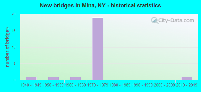
- New bridges - historical statistics
- 11940-1949
- 11950-1959
- 11960-1969
- 191970-1979
- 12010-2019
FCC Registered Antenna Towers:
13 (See the full list of FCC Registered Antenna Towers in Mina)FCC Registered Microwave Towers:
2- BU44HO360, Route 430 (Lat: 42.126444 Lon: -79.708917), Type: Ltower, Structure height: 91.4 m, Overall height: 92.9 m, Call Sign: WQSH463,
Assigned Frequencies: 23075.0 MHz, Grant Date: 09/19/2013, Expiration Date: 09/19/2023, Cancellation Date: 05/08/2023, Certifier: David Werblow, Registrant: T-Mobile Usa, Inc., 12920 Se 38th Street, Bellevue, WA 98006, Phone: (425) 383-8401, Email:
- BU33HO428, 3824 Stetson Road (Lat: 42.168083 Lon: -79.756194), Type: Ltower, Structure height: 76.2 m, Overall height: 79.2 m, Call Sign: WQSH464,
Assigned Frequencies: 21875.0 MHz, Grant Date: 09/19/2013, Expiration Date: 09/19/2023, Cancellation Date: 05/05/2023, Certifier: David Werblow, Registrant: T-Mobile Usa, Inc., 12920 Se 38th Street, Bellevue, WA 98006, Phone: (425) 383-8401, Email:
- 38.3%Utility gas
- 22.5%Bottled, tank, or LP gas
- 20.2%Fuel oil, kerosene, etc.
- 13.7%Wood
- 2.3%Electricity
- 2.3%Other fuel
- 0.5%No fuel used
- 47.8%Utility gas
- 19.4%Bottled, tank, or LP gas
- 11.9%Electricity
- 11.9%Fuel oil, kerosene, etc.
- 9.0%Wood
Mina compared to New York state average:
- Median house value significantly below state average.
- Unemployed percentage below state average.
- Black race population percentage significantly below state average.
- Hispanic race population percentage significantly below state average.
- Foreign-born population percentage significantly below state average.
- Renting percentage significantly below state average.
- Length of stay since moving in significantly above state average.
- Number of rooms per house significantly below state average.
- House age significantly below state average.
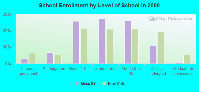
- Number of college students below state average.
- Percentage of population with a bachelor's degree or higher below state average.