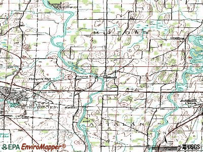
Milford, Wisconsin
Submit your own pictures of this town and show them to the world
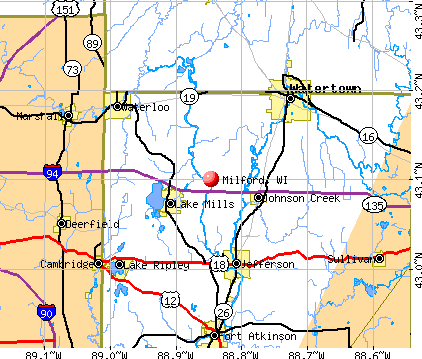
- OSM Map
- General Map
- Google Map
- MSN Map
Population change since 2000: +4.2%
 |
| Males: 575 | |
| Females: 524 |
| Median resident age: | 43.9 years |
| Wisconsin median age: | 42.6 years |
Zip codes: 53094.
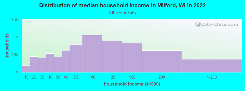
| Milford: | $79,832 |
| WI: | $70,996 |
Estimated per capita income in 2022: $41,427 (it was $22,953 in 2000)
Milford town income, earnings, and wages data
Estimated median house or condo value in 2022: $304,794 (it was $136,100 in 2000)
| Milford: | $304,794 |
| WI: | $252,800 |
Mean prices in 2022: all housing units: $311,639; detached houses: $324,328; townhouses or other attached units: $287,776; in 2-unit structures: $203,428; in 3-to-4-unit structures: $366,472; in 5-or-more-unit structures: $302,644; mobile homes: $58,612
Detailed information about poverty and poor residents in Milford, WI


- 1,04094.6%White alone
- 252.3%Hispanic
- 201.8%Two or more races
- 50.5%Black alone
- 50.5%Asian alone
- 20.2%American Indian alone
- 20.2%Native Hawaiian and Other
Pacific Islander alone
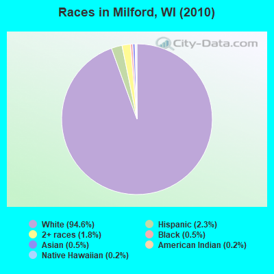
Races in Milford detailed stats: ancestries, foreign born residents, place of birth
 Recent articles from our blog. Our writers, many of them Ph.D. graduates or candidates, create easy-to-read articles on a wide variety of topics.

 | Is Walker's Point(5th Ward) Dangerous ? (2 replies) |
| --The Wisconsin Chat-- (1595 replies) |
Latest news from Milford, WI collected exclusively by city-data.com from local newspapers, TV, and radio stations
Ancestries: German (60.9%), Irish (7.9%), English (6.1%), Polish (4.5%), Norwegian (3.9%), United States (3.9%).
Current Local Time: CST time zone
Elevation: 811 feet
Land area: 33.9 square miles.
Population density: 32 people per square mile (very low).
17 residents are foreign born
| This town: | 1.6% |
| Wisconsin: | 3.6% |
| Milford town: | 1.3% ($1,737) |
| Wisconsin: | 2.0% ($2,245) |
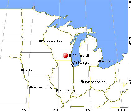
Nearest city with pop. 50,000+: Madison, WI  (28.7 miles , pop. 208,054).
Nearest city with pop. 1,000,000+: Chicago, IL (108.0 miles , pop. 2,896,016).
Nearest cities:
), ), ), )Latitude: 43.15 N, Longitude: 88.84 W
Area code commonly used in this area: 920

| Here: | 2.5% |
| Wisconsin: | 2.7% |
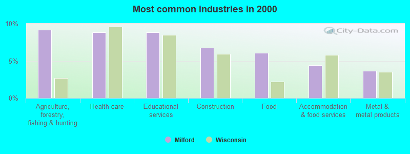
- Agriculture, forestry, fishing & hunting (9.2%)
- Health care (8.8%)
- Educational services (8.8%)
- Construction (6.8%)
- Food (6.1%)
- Accommodation & food services (4.4%)
- Metal & metal products (3.7%)
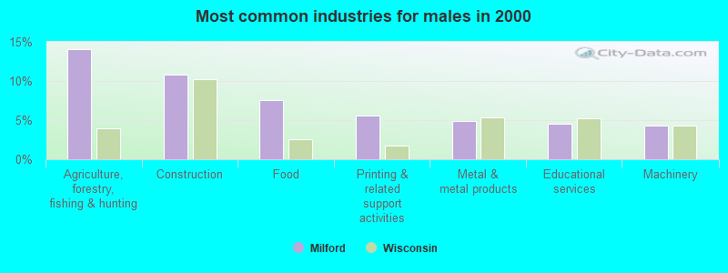
- Agriculture, forestry, fishing & hunting (14.1%)
- Construction (10.8%)
- Food (7.5%)
- Printing & related support activities (5.6%)
- Metal & metal products (4.9%)
- Educational services (4.6%)
- Machinery (4.2%)
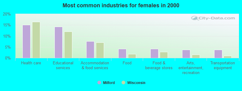
- Health care (15.1%)
- Educational services (14.2%)
- Accommodation & food services (7.5%)
- Food (4.2%)
- Food & beverage stores (4.2%)
- Arts, entertainment, recreation (3.8%)
- Transportation equipment (3.8%)
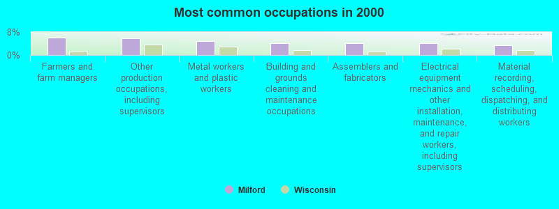
- Farmers and farm managers (6.1%)
- Other production occupations, including supervisors (5.9%)
- Metal workers and plastic workers (4.8%)
- Building and grounds cleaning and maintenance occupations (4.2%)
- Assemblers and fabricators (4.2%)
- Electrical equipment mechanics and other installation, maintenance, and repair workers, including supervisors (4.0%)
- Material recording, scheduling, dispatching, and distributing workers (3.5%)
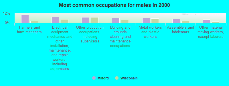
- Farmers and farm managers (10.1%)
- Electrical equipment mechanics and other installation, maintenance, and repair workers, including supervisors (7.2%)
- Other production occupations, including supervisors (6.9%)
- Building and grounds cleaning and maintenance occupations (6.2%)
- Metal workers and plastic workers (5.9%)
- Assemblers and fabricators (4.6%)
- Other material moving workers, except laborers (3.9%)
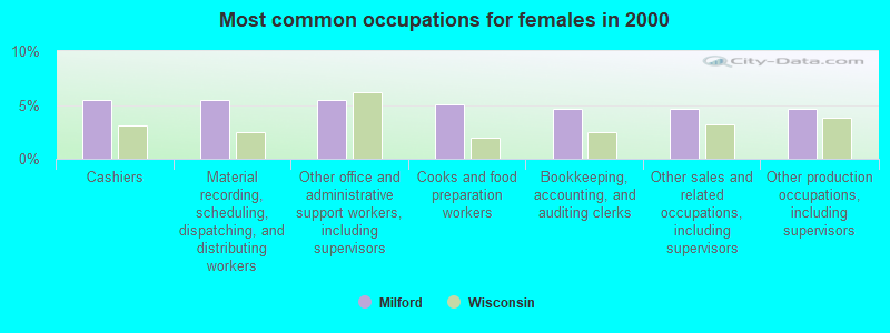
- Cashiers (5.4%)
- Material recording, scheduling, dispatching, and distributing workers (5.4%)
- Other office and administrative support workers, including supervisors (5.4%)
- Cooks and food preparation workers (5.0%)
- Bookkeeping, accounting, and auditing clerks (4.6%)
- Other sales and related occupations, including supervisors (4.6%)
- Other production occupations, including supervisors (4.6%)
Average climate in Milford, Wisconsin
Based on data reported by over 4,000 weather stations


(lower is better)
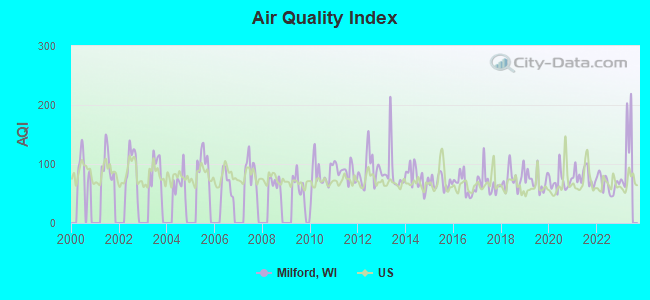
Air Quality Index (AQI) level in 2022 was 66.3. This is about average.
| City: | 66.3 |
| U.S.: | 72.6 |
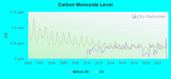
Carbon Monoxide (CO) [ppm] level in 2022 was 0.198. This is better than average. Closest monitor was 24.5 miles away from the city center.
| City: | 0.198 |
| U.S.: | 0.251 |
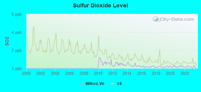
Sulfur Dioxide (SO2) [ppb] level in 2022 was 0.173. This is significantly better than average. Closest monitor was 22.0 miles away from the city center.
| City: | 0.173 |
| U.S.: | 1.515 |
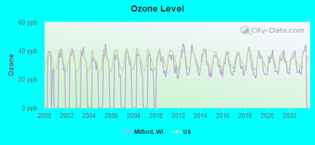
Ozone [ppb] level in 2022 was 31.1. This is about average. Closest monitor was 10.0 miles away from the city center.
| City: | 31.1 |
| U.S.: | 33.3 |
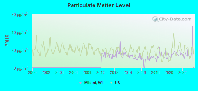
Particulate Matter (PM10) [µg/m3] level in 2022 was 14.1. This is better than average. Closest monitor was 24.5 miles away from the city center.
| City: | 14.1 |
| U.S.: | 19.2 |
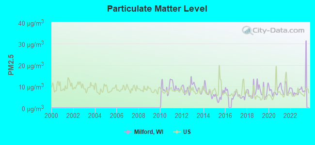
Particulate Matter (PM2.5) [µg/m3] level in 2022 was 7.50. This is about average. Closest monitor was 24.5 miles away from the city center.
| City: | 7.50 |
| U.S.: | 8.11 |
Tornado activity:
Milford-area historical tornado activity is above Wisconsin state average. It is 67% greater than the overall U.S. average.
On 6/7/1984, a category F5 (max. wind speeds 261-318 mph) tornado 35.7 miles away from the Milford town center killed 9 people and injured 200 people and caused between $50,000 and $500,000 in damages.
On 7/18/1996, a category F5 tornado 39.7 miles away from the town center injured 12 people and caused $40 million in damages.
Earthquake activity:
Milford-area historical earthquake activity is significantly above Wisconsin state average. It is 24% greater than the overall U.S. average.On 4/18/2008 at 09:36:59, a magnitude 5.4 (5.1 MB, 4.8 MS, 5.4 MW, 5.2 MW, Class: Moderate, Intensity: VI - VII) earthquake occurred 328.6 miles away from the city center
On 6/28/2004 at 06:10:52, a magnitude 4.2 (4.2 MW, Depth: 6.2 mi, Class: Light, Intensity: IV - V) earthquake occurred 116.8 miles away from Milford center
On 6/10/1987 at 23:48:54, a magnitude 5.1 (4.9 MB, 4.4 MS, 4.6 MS, 5.1 LG) earthquake occurred 303.4 miles away from Milford center
On 4/18/2008 at 09:36:59, a magnitude 5.2 (5.2 MW, Depth: 8.9 mi) earthquake occurred 328.7 miles away from Milford center
On 2/10/2010 at 09:59:35, a magnitude 3.8 (3.8 MW, Depth: 6.2 mi, Class: Light, Intensity: II - III) earthquake occurred 83.4 miles away from Milford center
On 5/2/2015 at 16:23:07, a magnitude 4.2 (4.2 MW, Depth: 2.8 mi) earthquake occurred 184.3 miles away from Milford center
Magnitude types: regional Lg-wave magnitude (LG), body-wave magnitude (MB), surface-wave magnitude (MS), moment magnitude (MW)
Natural disasters:
The number of natural disasters in Jefferson County (12) is smaller than the US average (15).Major Disasters (Presidential) Declared: 9
Emergencies Declared: 3
Causes of natural disasters: Storms: 8, Floods: 7, Tornadoes: 3, Drought: 1, Hurricane: 1, Snow: 1, Wind: 1, Other: 1 (Note: some incidents may be assigned to more than one category).
Hospitals and medical centers near Milford:
- WILLOWBROOK NURSING AND REHAB (Nursing Home, about 6 miles away; LAKE MILLS, WI)
- BETHESDA LUTHERAN HOME (Nursing Home, about 6 miles away; WATERTOWN, WI)
- WELBOURNE HALL RCF (Nursing Home, about 8 miles away; WATERTOWN, WI)
- MARQUARDT HOSPICE (Hospital, about 8 miles away; WATERTOWN, WI)
- MARQUARDT MEMORIAL MANOR (Nursing Home, about 8 miles away; WATERTOWN, WI)
- GOLDEN LIVINGCENTER-WATERTOWN (Nursing Home, about 8 miles away; WATERTOWN, WI)
- PURITY DIALYSIS - WATERTOWN (Dialysis Facility, about 8 miles away; WATERTOWN, WI)
Colleges/universities with over 2000 students nearest to Milford:
- University of Wisconsin-Whitewater (about 23 miles; Whitewater, WI; Full-time enrollment: 11,124)
- Herzing University-Madison (about 24 miles; Madison, WI; FT enrollment: 3,160)
- Madison Area Technical College (about 26 miles; Madison, WI; FT enrollment: 9,603)
- University of Wisconsin Colleges (about 30 miles; Madison, WI; FT enrollment: 10,019)
- University of Wisconsin-Madison (about 30 miles; Madison, WI; FT enrollment: 34,621)
- Waukesha County Technical College (about 30 miles; Pewaukee, WI; FT enrollment: 4,415)
- Edgewood College (about 31 miles; Madison, WI; FT enrollment: 2,455)
Points of interest:
Churches in Milford include: United Brethren Church (A), Mamre Church (B). Display/hide their locations on the map
Cemetery: Church Hill Cemetery (1). Display/hide its location on the map
Lakes and reservoirs: Hahns Lake (A), Hoopers Millpond 16 (B). Display/hide their locations on the map
Creek: Rock Creek (A). Display/hide its location on the map
Parks in Milford include: Faville Prairie State Natural Area (1), Snapper Prairie State Natural Area (2). Display/hide their locations on the map
| This town: | 2.6 people |
| Wisconsin: | 2.4 people |
| This town: | 74.1% |
| Whole state: | 64.4% |
| This town: | 6.1% |
| Whole state: | 7.3% |
Likely homosexual households (counted as self-reported same-sex unmarried-partner households)
- Lesbian couples: 0.7% of all households
- Gay men: 0.5% of all households
| This town: | 4.1% |
| Whole state: | 8.7% |
| This town: | 2.4% |
| Whole state: | 3.7% |
For population 15 years and over in Milford:
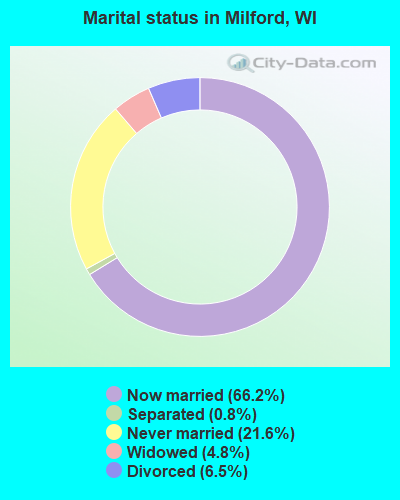
- Never married: 21.6%
- Now married: 66.2%
- Separated: 0.8%
- Widowed: 4.8%
- Divorced: 6.5%
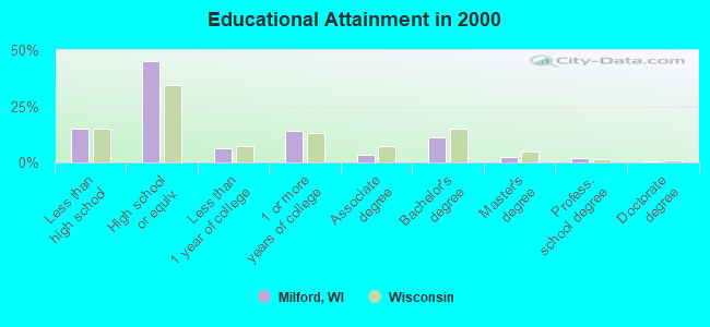
For population 25 years and over in Milford:
- High school or higher: 85.1%
- Bachelor's degree or higher: 15.9%
- Graduate or professional degree: 4.6%
- Unemployed: 2.9%
- Mean travel time to work (commute): 22.0 minutes
| Here: | 10.6 |
| Wisconsin average: | 11.0 |
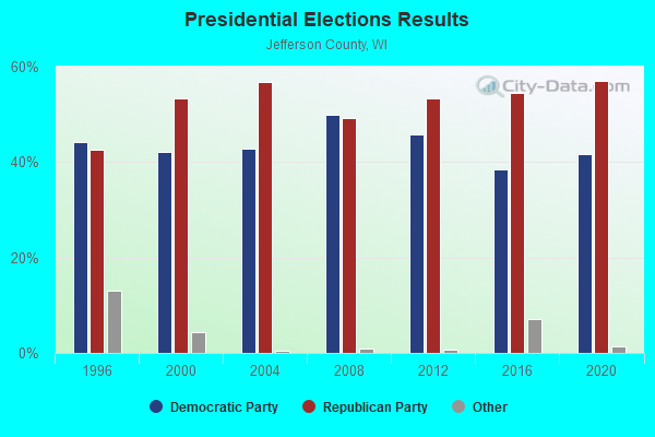
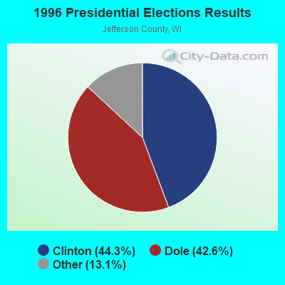
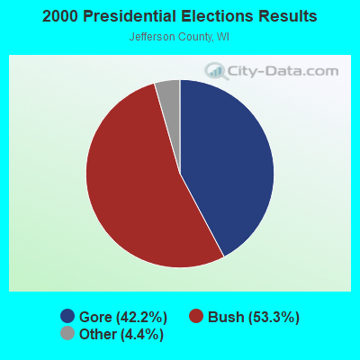
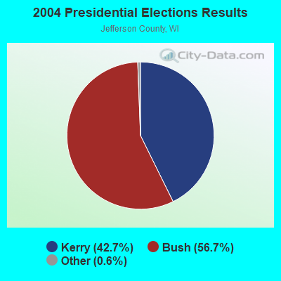
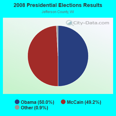
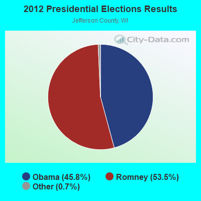
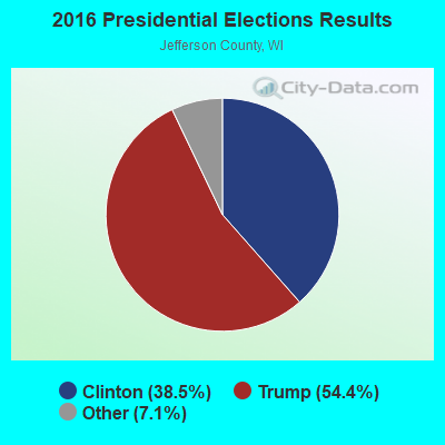
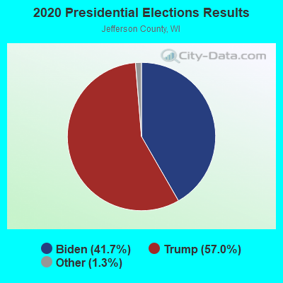
Graphs represent county-level data. Detailed 2008 Election Results
Religion statistics for Milford, WI (based on Jefferson County data)
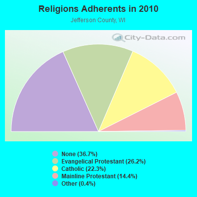
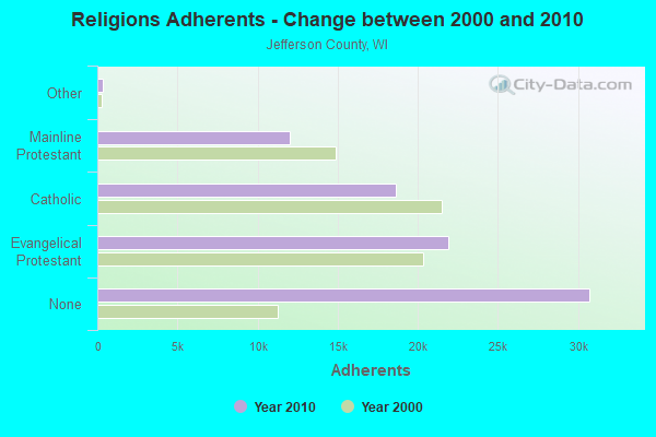
| Religion | Adherents | Congregations |
|---|---|---|
| Evangelical Protestant | 21,916 | 50 |
| Catholic | 18,637 | 10 |
| Mainline Protestant | 12,030 | 33 |
| Other | 364 | 5 |
| None | 30,739 | - |
Food Environment Statistics:
| This county: | 2.00 / 10,000 pop. |
| Wisconsin: | 1.86 / 10,000 pop. |
| Jefferson County: | 3.87 / 10,000 pop. |
| State: | 4.12 / 10,000 pop. |
| Jefferson County: | 9.12 / 10,000 pop. |
| Wisconsin: | 8.64 / 10,000 pop. |
| This county: | 7.2% |
| State: | 7.6% |
| Jefferson County: | 28.0% |
| Wisconsin: | 27.5% |
| Jefferson County: | 15.7% |
| State: | 13.0% |
Strongest AM radio stations in Milford:
- WTMJ (620 AM; 50 kW; MILWAUKEE, WI; Owner: JOURNAL BROADCAST CORPORATION)
- WTTN (1580 AM; 1 kW; WATERTOWN, WI; Owner: GOOD KARMA BROADCASTING, LLC)
- WISN (1130 AM; 50 kW; MILWAUKEE, WI; Owner: CAPSTAR TX LIMITED PARTNERSHIP)
- WTSO (1070 AM; 10 kW; MADISON, WI; Owner: CAPSTAR TX LIMITED PARTNERSHIP)
- WNWC (1190 AM; daytime; 5 kW; SUN PRAIRIE, WI; Owner: NORTHWESTERN COLLEGE)
- WNAM (1280 AM; 50 kW; NEENAH-MENASHA, WI; Owner: CUMULUS LICENSING CORP.)
- WGN (720 AM; 50 kW; CHICAGO, IL; Owner: WGN CONTINENTAL BROADCASTING CO.)
- WSCR (670 AM; 50 kW; CHICAGO, IL; Owner: INFINITY BROADCASTING OPERATIONS, INC.)
- WLMV (1480 AM; 10 kW; MADISON, WI; Owner: MID-WEST MANAGEMENT, INC.)
- WBBM (780 AM; 50 kW; CHICAGO, IL; Owner: INFINITY BROADCASTING OPERATIONS, INC.)
- WTDY (1670 AM; 10 kW; MADISON, WI; Owner: MID-WEST MANAGEMENT, INC.)
- WAUK (1510 AM; daytime; 10 kW; WAUKESHA, WI; Owner: WALT-WEST WISCONSIN, INC.)
- WKSH (1640 AM; 10 kW; SUSSEX, WI; Owner: ABC, INC.)
Strongest FM radio stations in Milford:
- WJJO (94.1 FM; WATERTOWN, WI; Owner: MID-WEST MANAGMENT, INC.)
- W277AC (103.3 FM; WATERTOWN, WI; Owner: NEWRADIO GROUP, LLC)
- WERN (88.7 FM; MADISON, WI; Owner: STATE OF WISCONSIN - EDUCATIONAL COMMUNICATIONS BOARD)
- WHAD (90.7 FM; DELAFIELD, WI; Owner: STATE OF WISCONSIN - EDUCATIONAL COMMUNICATIONS BOARD)
- WZEE (104.1 FM; MADISON, WI; Owner: CAPSTAR TX LIMITED PARTNERSHIP)
- WORT (89.9 FM; MADISON, WI; Owner: BACK PORCH RADIO BROADCASTING, INC.)
- WIBA-FM (101.5 FM; MADISON, WI; Owner: CAPSTAR TX LIMITED PARTNERSHIP)
- WSJY (107.3 FM; FORT ATKINSON, WI; Owner: NEWRADIO GROUP, LLC)
- WOLX-FM (94.9 FM; BARABOO, WI; Owner: ENTERCOM MADISON LICENSE, LLC.)
- WKCH (106.5 FM; WHITEWATER, WI; Owner: NEWRADIO GROUP, LLC)
- WMAD-FM (92.1 FM; SUN PRAIRIE, WI; Owner: CAPSTAR TX LIMITED PARTNERSHIP)
- WJWD (90.3 FM; MARSHALL, WI; Owner: CSN INTERNATIONAL)
- WHIT-FM (93.1 FM; DE FOREST, WI; Owner: MID-WEST MANAGEMENT, INC.)
- WTLX (100.5 FM; COLUMBUS, WI; Owner: GOOD KARMA BROADCASTING, L.L.C.)
- WMGN (98.1 FM; MADISON, WI; Owner: MID-WEST MANAGEMENT, INC.)
- WFZH (105.3 FM; MUKWONAGO, WI; Owner: CARON BROADCASTING, INC.)
- WXRO (95.3 FM; BEAVER DAM, WI; Owner: GOOD KARMA BROADCASTING, L.L.C.)
- WBZU (105.1 FM; WAUNAKEE, WI; Owner: ENTERCOM MADISON LICENSE, LLC.)
- WMDC (98.7 FM; MAYVILLE, WI; Owner: RADIO PLUS, INC.)
TV broadcast stations around Milford:
- WWRS-TV (Channel 52; MAYVILLE, WI; Owner: NATIONAL MINORITY T.V., INC.)
- WISC-TV (Channel 3; MADISON, WI; Owner: TELEVISION WISCONSIN, INC.)
- WMSN-TV (Channel 47; MADISON, WI; Owner: WMSN LICENSEE, LLC)
- WKOW-TV (Channel 27; MADISON, WI; Owner: WKOW TELEVISION, INC.)
- WHA-TV (Channel 21; MADISON, WI; Owner: BOARD OF REGENTS OF THE UNIV. OF WISCONSIN SYSTEM)
- WMTV (Channel 15; MADISON, WI; Owner: GRAY MIDAMERICA TV LICENSEE CORP.)
- WMMF-TV (Channel 68; FOND DU LAC, WI; Owner: PAPPAS TELECASTING OF WISCONSIN, A CALIFORNIA LTD PARTNRSHP)
- WDJT-TV (Channel 58; MILWAUKEE, WI; Owner: WDJT-TV LIMITED PARTNERSHIP)
- WISN-TV (Channel 12; MILWAUKEE, WI; Owner: WISN HEARST-ARGYLE TV, INC. (CA CORP.))
- WPXE (Channel 55; KENOSHA, WI; Owner: PAXSON MILWAUKEE LICENSE, INC.)
- WMVS (Channel 10; MILWAUKEE, WI; Owner: MILWAUKEE AREA TECHNICAL COLLEGE DISTRICT BOARD)
- WMVT (Channel 36; MILWAUKEE, WI; Owner: MILWAUKEE AREA TECHNICAL COLLEGE DISTRICT BOARD)
- WITI (Channel 6; MILWAUKEE, WI; Owner: WITI LICENSE,INC.)
- WCGV-TV (Channel 24; MILWAUKEE, WI; Owner: WCGV LICENSEE, LLC)
- WMLW-CA (Channel 46; MILWAUKEE, WI; Owner: CHANNEL 41 AND 63 LIMITED PARTNERSHIP)
- W63CU (Channel 63; MILWAUKEE, WI; Owner: CHANNEL 41 AND 63 LIMITED PARTNERSHIP)
- W23BW (Channel 23; MADISON, WI; Owner: THREE ANGELS BROADCASTING NETWORK)
- National Bridge Inventory (NBI) Statistics
- 6Number of bridges
- 39ft / 11.7mTotal length
- 70,950Total average daily traffic
- 11,763Total average daily truck traffic
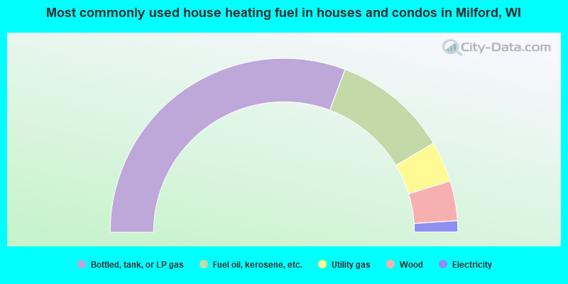
- 61.5%Bottled, tank, or LP gas
- 21.5%Fuel oil, kerosene, etc.
- 7.6%Utility gas
- 7.4%Wood
- 2.1%Electricity
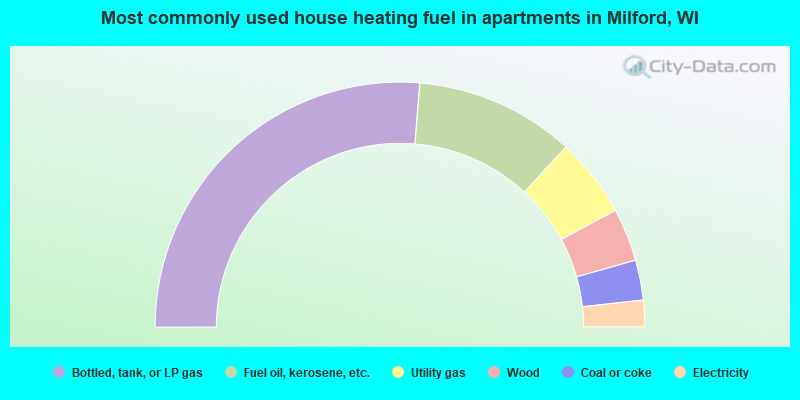
- 52.6%Bottled, tank, or LP gas
- 21.1%Fuel oil, kerosene, etc.
- 10.5%Utility gas
- 7.0%Wood
- 5.3%Coal or coke
- 3.5%Electricity
Milford compared to Wisconsin state average:
- Unemployed percentage significantly below state average.
- Black race population percentage significantly below state average.
- Hispanic race population percentage significantly below state average.
- Foreign-born population percentage significantly below state average.
- Renting percentage significantly below state average.
- Length of stay since moving in significantly above state average.
- Number of rooms per house significantly below state average.
- House age significantly below state average.
- Number of college students below state average.