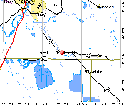
Merrill, Oregon
Merrill: Merrill home.....
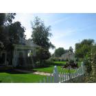
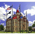
Merrill: Civic Center....
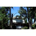
Merrill: This old house.....
Merrill: Meat on the hoof.....
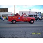
Merrill: Annual Potato Festival parade
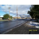
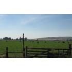
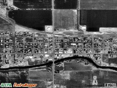
Merrill: Looking north at the north end of Merrill
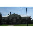
Merrill
Merrill

Merrill
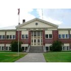
Merrill: Merrill, Oregon: This old school now serves as a civic center and the grounds are a nice park.
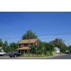
Merrill: Red House....
- see
20
more - add
your


Submit your own pictures of this city and show them to the world
- OSM Map
- General Map
- Google Map
- MSN Map
Population change since 2000: -6.9%
 |
| Males: 453 | |
| Females: 382 |
| Median resident age: | 29.9 years |
| Oregon median age: | 40.5 years |
Zip codes: 97633.
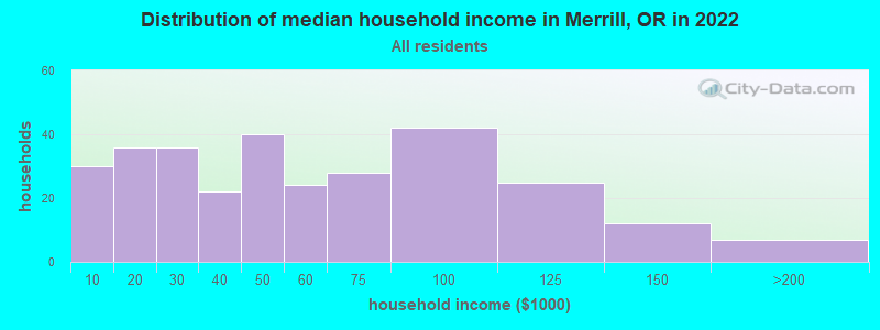
| Merrill: | $49,672 |
| OR: | $75,657 |
Estimated per capita income in 2022: $22,810 (it was $11,803 in 2000)
Merrill city income, earnings, and wages data
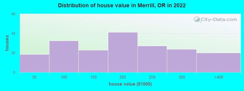
Estimated median house or condo value in 2022: $194,219 (it was $61,200 in 2000)
| Merrill: | $194,219 |
| OR: | $475,600 |
Mean prices in 2022: all housing units: $156,154; detached houses: $172,175; mobile homes: $93,469
Median gross rent in 2022: $690.
(9.5% for White Non-Hispanic residents, 70.8% for Black residents, 10.0% for Hispanic or Latino residents, 75.0% for American Indian residents)
Detailed information about poverty and poor residents in Merrill, OR
Compare current foreclosures near Merrill, OR:
| Photo | Address | Area | Beds / Baths | Price | Details |
|---|---|---|---|---|---|

|
#1
S Ca St
Dorris, CA 96023
|
1,700 sq. feet
|
3 baths 6 beds |
show details | |

|
#2
Elliott Rd
Klamath Falls, OR 97603
|
1,196 sq. feet
|
2 baths 4 beds |
show details | |

|
#3
Altamont Dr
Klamath Falls, OR 97603
|
914 sq. feet
|
1 baths 2 beds |
show details | |

|
#4
Michigan Ave
Klamath Falls, OR 97601
|
975 sq. feet
|
1 baths 2 beds |
show details | |

|
#5
Garden Ave
Klamath Falls, OR 97601
|
1,531 sq. feet
|
1 baths 4 beds |
show details | |

|
#6
Douglas Ave
Klamath Falls, OR 97601
|
856 sq. feet
|
1 baths 2 beds |
show details | |

|
#7
Shasta Way
Klamath Falls, OR 97603
|
1,064 sq. feet
|
1 baths 3 beds |
show details | |

|
#8
Etna St
Klamath Falls, OR 97603
|
- sq. feet
|
2 baths 3 beds |
show details | |

|
#9
Paramont St
Klamath Falls, OR 97603
|
- sq. feet
|
2 baths 3 beds |
show details | |

|
#10
Cortez St
Klamath Falls, OR 97601
|
2,392 sq. feet
|
2 baths 4 beds |
show details |
| Photo | Address | Area | Beds / Baths | Price | Details |
|---|---|---|---|---|---|

|
#11
Climax Ave
Klamath Falls, OR 97603
|
1,537 sq. feet
|
2 baths 3 beds |
show details | |

|
#12
Bryant Ave
Klamath Falls, OR 97603
|
2,341 sq. feet
|
3 baths 3 beds |
show details | |

|
#13
Delaware Ave
Klamath Falls, OR 97603
|
736 sq. feet
|
1 baths 2 beds |
show details | |

|
#14
Fargo St
Klamath Falls, OR 97603
|
957 sq. feet
|
1 baths 3 beds |
show details | |

|
#15
Kane St
Klamath Falls, OR 97603
|
572 sq. feet
|
1 baths 3 beds |
show details | |

|
#16
Shasta Way
Klamath Falls, OR 97603
|
1,440 sq. feet
|
2 baths 3 beds |
show details | |

|
#17
White Ave
Klamath Falls, OR 97601
|
1,034 sq. feet
|
1 baths 2 beds |
show details | |

|
#18
Applewood St
Klamath Falls, OR 97603
|
1,415 sq. feet
|
1 baths 3 beds |
show details | |

|
#19
Dawn Dr
Klamath Falls, OR 97603
|
1,484 sq. feet
|
2 baths 3 beds |
show details | |

|
#20
Beverly Dr
Klamath Falls, OR 97603
|
1,898 sq. feet
|
2 baths 4 beds |
show details |
| Photo | Address | Area | Beds / Baths | Price | Details |
|---|---|---|---|---|---|

|
#21
Orchard Ave
Klamath Falls, OR 97601
|
1,217 sq. feet
|
1 baths 3 beds |
show details | |

|
#22
Garden Ave
Klamath Falls, OR 97601
|
1,304 sq. feet
|
2 baths 3 beds |
show details | |

|
#23
Plum Ave
Klamath Falls, OR 97601
|
622 sq. feet
|
1 baths 1 beds |
show details | |

|
#24
Wall St
Klamath Falls, OR 97601
|
1,300 sq. feet
|
1 baths 4 beds |
show details | |

|
#25
Michigan Ave
Klamath Falls, OR 97601
|
1,043 sq. feet
|
1 baths 3 beds |
show details | |

|
#26
Huron St
Klamath Falls, OR 97601
|
2,373 sq. feet
|
2 baths 4 beds |
show details | |

|
#27
Earle St
Klamath Falls, OR 97601
|
2,376 sq. feet
|
2 baths 3 beds |
show details | |

|
#28
Grant St
Klamath Falls, OR 97601
|
1,484 sq. feet
|
2 baths 2 beds |
show details | |

|
#29
Climax Ave
Klamath Falls, OR 97603
|
1,712 sq. feet
|
2 baths 3 beds |
show details | |

|
#30
Buesing Rd # B
Klamath Falls, OR 97603
|
3,616 sq. feet
|
3 baths 4 beds |
show details |
| Photo | Address | Area | Beds / Baths | Price | Details |
|---|---|---|---|---|---|

|
#31
Homedale Rd
Klamath Falls, OR 97603
|
1,836 sq. feet
|
2 baths 3 beds |
show details | |

|
#32
Mazama Dr
Klamath Falls, OR 97603
|
1,230 sq. feet
|
1 baths 3 beds |
show details | |

|
#33
E County Road 104
Tulelake, CA 96134
|
1,484 sq. feet
|
1 baths 3 beds |
show details | |

|
#34
Liberty Ave
Klamath Falls, OR 97603
|
1,563 sq. feet
|
2 baths 3 beds |
show details | |

|
#35
Gatewood Dr
Klamath Falls, OR 97603
|
1,468 sq. feet
|
2 baths 3 beds |
show details | |

|
#36
Philpott Ln
Bonanza, OR 97623
|
1,863 sq. feet
|
2 baths 3 beds |
show details | |

|
#37
Rio Vista Way
Klamath Falls, OR 97603
|
1,922 sq. feet
|
2 baths 3 beds |
show details | |

|
#38
Sumac Ave
Klamath Falls, OR 97603
|
1,782 sq. feet
|
2 baths 3 beds |
show details | |

|
#39
Harlan Dr
Klamath Falls, OR 97603
|
1,983 sq. feet
|
2 baths 4 beds |
show details | |

|
#40
Villa Dr
Klamath Falls, OR 97603
|
2,572 sq. feet
|
3 baths 5 beds |
show details |
| Photo | Address | Area | Beds / Baths | Price | Details |
|---|---|---|---|---|---|

|
#41
Sturdivant Ave
Klamath Falls, OR 97603
|
1,302 sq. feet
|
2 baths 3 beds |
show details | |

|
#42
Sturdivant Ave
Klamath Falls, OR 97603
|
797 sq. feet
|
1 baths 2 beds |
show details | |

|
#43
Kelley Dr
Klamath Falls, OR 97603
|
1,040 sq. feet
|
1 baths 3 beds |
show details | |

|
#44
Barry Ave
Klamath Falls, OR 97603
|
1,208 sq. feet
|
1 baths 3 beds |
show details | |

|
#45
Jensen Ln
Klamath Falls, OR 97603
|
1,456 sq. feet
|
2 baths 3 beds |
show details | |

|
#46
Homedale Rd
Klamath Falls, OR 97603
|
957 sq. feet
|
1 baths 2 beds |
show details | |

|
#47
Madison St
Klamath Falls, OR 97603
|
1,676 sq. feet
|
2 baths 3 beds |
show details | |

|
#48
Wiard St
Klamath Falls, OR 97603
|
1,044 sq. feet
|
1 baths 3 beds |
show details | |

|
#49
Western St
Klamath Falls, OR 97603
|
1,760 sq. feet
|
2 baths 2 beds |
show details | |

|
Check over 1 million property listings on Foreclosure.com!
|
browse all offers | |||


- 52957.9%Hispanic
- 34437.6%White alone
- 293.2%Black alone
- 192.1%Two or more races
- 80.9%American Indian alone
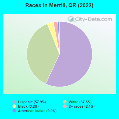
Races in Merrill detailed stats: ancestries, foreign born residents, place of birth
 Recent articles from our blog. Our writers, many of them Ph.D. graduates or candidates, create easy-to-read articles on a wide variety of topics.


 | Bandon relocation opinions (36 replies) |
| Housing bubble?? (114 replies) |
| route to Bend from Nevada (6 replies) |
| Communications between Sprague River and Bonanza (8 replies) |
| (I found this weird CA/OR/Weather-Prediction Online) ?? (9 replies) |
| best schools in Roseburg? Family friendly? (10 replies) |
Latest news from Merrill, OR collected exclusively by city-data.com from local newspapers, TV, and radio stations
Ancestries: Irish (8.6%), German (7.0%), American (4.1%), English (3.7%), Swedish (1.3%), Dutch (1.2%).
Current Local Time: PST time zone
Incorporated in 1903
Elevation: 4067 feet
Land area: 0.44 square miles.
Population density: 1,904 people per square mile (low).
92 residents are foreign born (10.0% Latin America).
| This city: | 10.1% |
| Oregon: | 9.8% |
Median real estate property taxes paid for housing units with mortgages in 2022: $1,054 (0.7%)
Median real estate property taxes paid for housing units with no mortgage in 2022: $1,122 (0.6%)
Nearest city with pop. 50,000+: Medford, OR  (68.1 miles , pop. 63,154).
Nearest city with pop. 200,000+: Northwest Clackamas, OR (238.7 miles , pop. 224,220).
Nearest city with pop. 1,000,000+: Los Angeles, CA (576.4 miles , pop. 3,694,820).
Nearest cities:
), ), ), )Latitude: 42.03 N, Longitude: 121.60 W
Area code: 541
Single-family new house construction building permits:
- 1997: 1 building, cost: $152,700
| Here: | 5.6% |
| Oregon: | 3.9% |
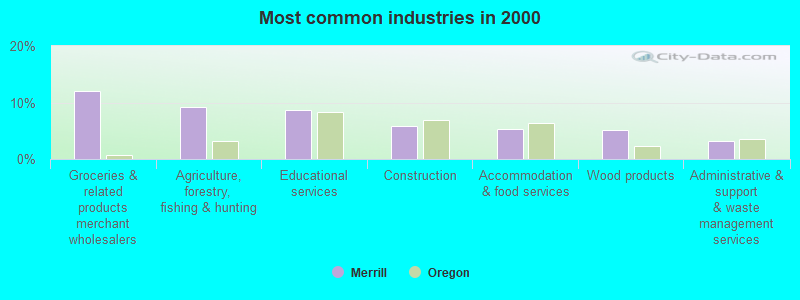
- Groceries & related products merchant wholesalers (12.1%)
- Agriculture, forestry, fishing & hunting (9.1%)
- Educational services (8.6%)
- Construction (5.9%)
- Accommodation & food services (5.4%)
- Wood products (5.1%)
- Administrative & support & waste management services (3.2%)

- Agriculture, forestry, fishing & hunting (15.0%)
- Groceries & related products merchant wholesalers (12.1%)
- Construction (10.6%)
- Wood products (4.8%)
- Arts, entertainment, recreation (4.3%)
- Educational services (4.3%)
- Administrative & support & waste management services (4.3%)

- Educational services (13.9%)
- Groceries & related products merchant wholesalers (12.1%)
- Accommodation & food services (7.9%)
- Social assistance (5.5%)
- Wood products (5.5%)
- Health care (4.2%)
- Pharmacies & drug stores (4.2%)

- Agricultural workers, including supervisors (11.6%)
- Driver/sales workers and truck drivers (7.8%)
- Other production occupations, including supervisors (7.0%)
- Other sales and related occupations, including supervisors (5.1%)
- Building and grounds cleaning and maintenance occupations (4.3%)
- Laborers and material movers, hand (4.3%)
- Retail sales workers, except cashiers (3.2%)

- Agricultural workers, including supervisors (12.6%)
- Driver/sales workers and truck drivers (12.6%)
- Other production occupations, including supervisors (8.7%)
- Laborers and material movers, hand (5.3%)
- Other material moving workers, except laborers (4.8%)
- Metal workers and plastic workers (4.3%)
- Other sales and related occupations, including supervisors (3.9%)

- Agricultural workers, including supervisors (10.3%)
- Other sales and related occupations, including supervisors (6.7%)
- Secretaries and administrative assistants (6.7%)
- Bookkeeping, accounting, and auditing clerks (6.1%)
- Retail sales workers, except cashiers (6.1%)
- Preschool, kindergarten, elementary, and middle school teachers (4.8%)
- Building and grounds cleaning and maintenance occupations (4.8%)
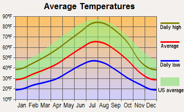
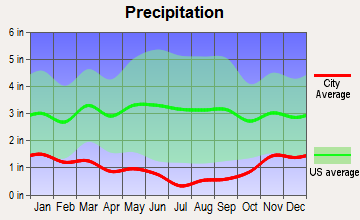
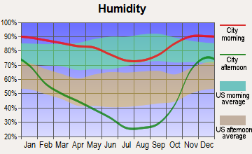
Average climate in Merrill, Oregon
Based on data reported by over 4,000 weather stations
(lower is better)
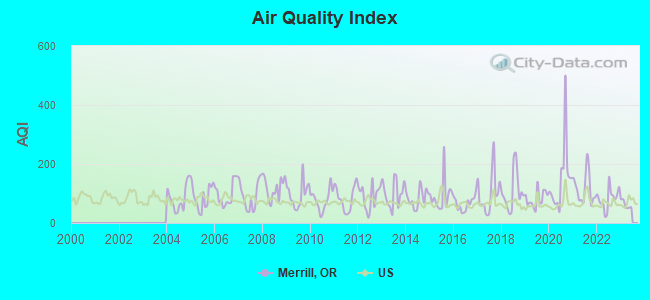
Air Quality Index (AQI) level in 2022 was 83.2. This is about average.
| City: | 83.2 |
| U.S.: | 72.6 |
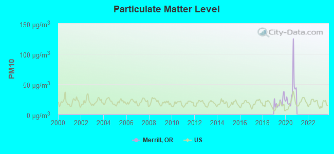
Particulate Matter (PM10) [µg/m3] level in 2020 was 36.9. This is significantly worse than average. Closest monitor was 13.2 miles away from the city center.
| City: | 36.9 |
| U.S.: | 19.2 |
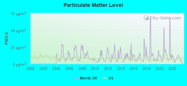
Particulate Matter (PM2.5) [µg/m3] level in 2022 was 8.21. This is about average. Closest monitor was 13.2 miles away from the city center.
| City: | 8.21 |
| U.S.: | 8.11 |
Earthquake activity:
Merrill-area historical earthquake activity is significantly above Oregon state average. It is 3818% greater than the overall U.S. average.On 4/18/1906 at 13:12:21, a magnitude 7.9 (7.9 UK, Class: Major, Intensity: VIII - XII) earthquake occurred 288.1 miles away from the city center, causing $524,000,000 total damage
On 1/31/1922 at 13:17:28, a magnitude 7.6 (7.6 UK) earthquake occurred 224.8 miles away from Merrill center
On 10/3/1915 at 06:52:48, a magnitude 7.6 (7.6 UK) earthquake occurred 237.8 miles away from the city center
On 11/8/1980 at 10:27:34, a magnitude 7.2 (6.2 MB, 7.2 MS, 7.2 MW, 7.0 ML) earthquake occurred 153.4 miles away from the city center
On 4/25/1992 at 18:06:04, a magnitude 7.2 (6.3 MB, 7.1 MS, 7.2 MW, 7.1 MW, Depth: 9.4 mi) earthquake occurred 173.0 miles away from the city center, causing $75,000,000 total damage
On 1/22/1923 at 09:04:18, a magnitude 7.2 (7.2 UK) earthquake occurred 220.9 miles away from Merrill center
Magnitude types: body-wave magnitude (MB), local magnitude (ML), surface-wave magnitude (MS), moment magnitude (MW)
Natural disasters:
The number of natural disasters in Klamath County (8) is smaller than the US average (15).Major Disasters (Presidential) Declared: 4
Emergencies Declared: 2
Causes of natural disasters: Fires: 2, Floods: 2, Drought: 1, Earthquake: 1, Heavy Rain: 1, Hurricane: 1, Wind: 1, Winter Storm: 1, Other: 1 (Note: some incidents may be assigned to more than one category).

Hospitals and medical centers near Merrill:
- SKY LAKES HOME HEALTH (Home Health Center, about 15 miles away; KLAMATH FALLS, OR)
- KLAMATH HOSPICE, INC (Hospital, about 16 miles away; KLAMATH FALLS, OR)
- HIGH DESERT HOSPICE LLC (Hospital, about 16 miles away; KLAMATH FALLS, OR)
- KLAMATH REGIONAL REHAB CT (Nursing Home, about 16 miles away; KLAMATH FALLS, OR)
- MOUNTAIN VIEW CARE CENTER (Nursing Home, about 16 miles away; KLAMATH FALLS, OR)
Airports located in Merrill:
- Long Ranch Airport (0OR3) (Runways: 1)
Colleges/universities with over 2000 students nearest to Merrill:
- Oregon Institute of Technology (about 19 miles; Klamath Falls, OR; Full-time enrollment: 2,900)
- Southern Oregon University (about 58 miles; Ashland, OR; FT enrollment: 4,650)
- Rogue Community College (about 96 miles; Grants Pass, OR; FT enrollment: 3,600)
- Shasta College (about 104 miles; Redding, CA; FT enrollment: 5,645)
- Central Oregon Community College (about 143 miles; Bend, OR; FT enrollment: 5,217)
- Humboldt State University (about 152 miles; Arcata, CA; FT enrollment: 7,353)
- Lane Community College (about 156 miles; Eugene, OR; FT enrollment: 6,373)
Public high school in Merrill:
- LOST RIVER HIGH SCHOOL (Students: 291, Location: 23330 HWY 50, Grades: 7-12)
Public elementary/middle school in Merrill:
- MERRILL ELEMENTARY SCHOOL (Students: 154, Location: 406 W SECOND ST, Grades: KG-6)
Points of interest:
Notable locations in Merrill: Klamath County Library Merrill Branch (A), Merrill Public Works Department Office (B), Merrill City Hall (C), Merrill Rural Fire Protection District (D). Display/hide their locations on the map
Birthplace of: Carl Barks - (1901-2000), Donald Duck cartoonist.
Drinking water stations with addresses in Merrill and their reported violations in the past:
MERRILL WATER DEPARTMENT (Population served: 907, Groundwater):Past health violations:Past monitoring violations:
- MCL, Monthly (TCR) - In AUG-2007, Contaminant: Coliform. Follow-up actions: St Compliance achieved (SEP-06-2007)
- 2 routine major monitoring violations
- 2 regular monitoring violations
| This city: | 2.7 people |
| Oregon: | 2.5 people |
| This city: | 71.8% |
| Whole state: | 63.4% |
| This city: | 6.8% |
| Whole state: | 8.0% |
Likely homosexual households (counted as self-reported same-sex unmarried-partner households)
- Lesbian couples: 0.0% of all households
- Gay men: 0.3% of all households
Banks with branches in Merrill (2011 data):
- Sterling Savings Bank: Merrill Branch at 206 East Front Street, branch established on 1900/01/01. Info updated 2012/03/21: Bank assets: $9,207.8 mil, Deposits: $6,454.1 mil, headquarters in Spokane, WA, positive income, Commercial Lending Specialization, 192 total offices, Holding Company: Sterling Financial Corporation
For population 15 years and over in Merrill:
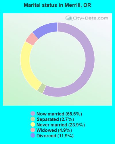
- Never married: 23.9%
- Now married: 56.6%
- Separated: 2.7%
- Widowed: 4.9%
- Divorced: 11.9%
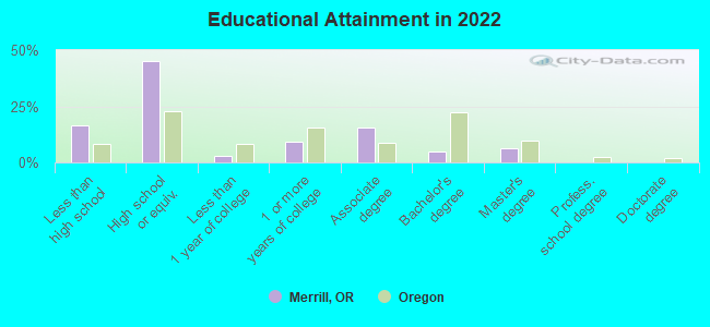
For population 25 years and over in Merrill:
- High school or higher: 80.3%
- Bachelor's degree or higher: 10.1%
- Graduate or professional degree: 4.9%
- Unemployed: 9.0%
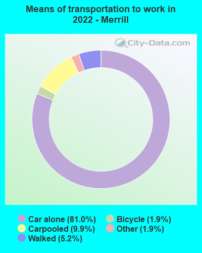
- Mean travel time to work (commute): 19.8 minutes
| Here: | 10.7 |
| Oregon average: | 11.6 |
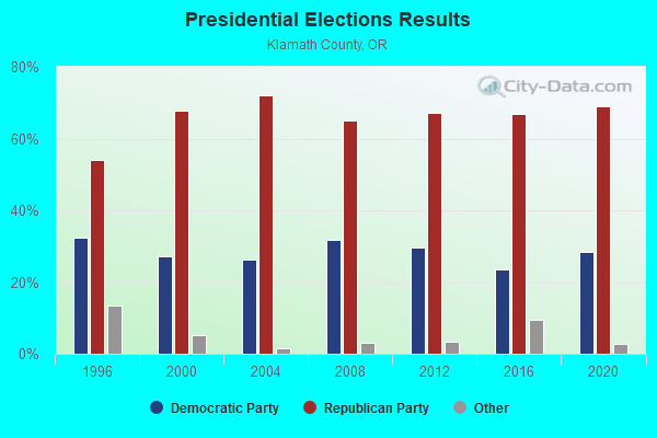
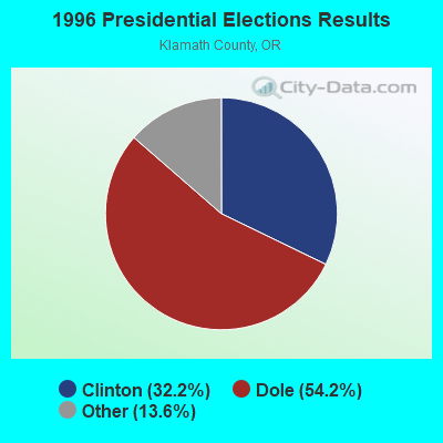
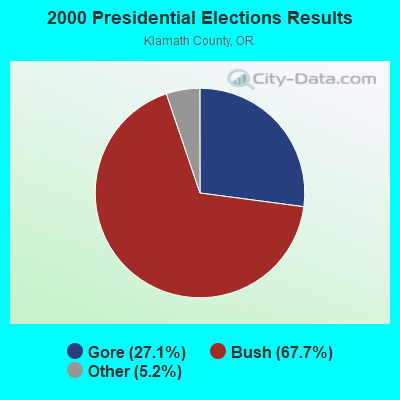

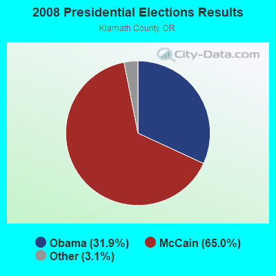
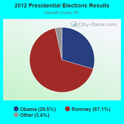
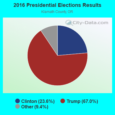
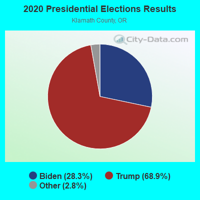
Graphs represent county-level data. Detailed 2008 Election Results
Religion statistics for Merrill, OR (based on Klamath County data)
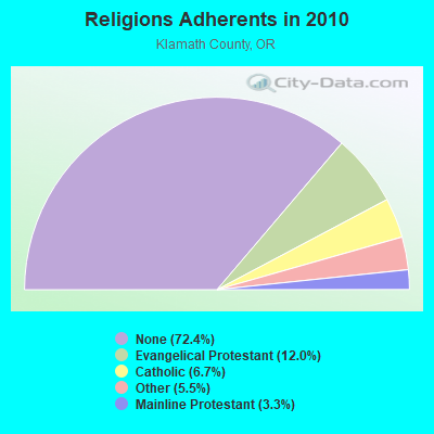
| Religion | Adherents | Congregations |
|---|---|---|
| Evangelical Protestant | 7,945 | 63 |
| Catholic | 4,460 | 7 |
| Other | 3,677 | 14 |
| Mainline Protestant | 2,218 | 14 |
| Black Protestant | 30 | 1 |
| None | 48,050 | - |
Food Environment Statistics:
| This county: | 2.41 / 10,000 pop. |
| Oregon: | 2.03 / 10,000 pop. |
| This county: | 0.30 / 10,000 pop. |
| Oregon: | 0.33 / 10,000 pop. |
| This county: | 1.81 / 10,000 pop. |
| Oregon: | 2.01 / 10,000 pop. |
| Klamath County: | 2.71 / 10,000 pop. |
| State: | 1.69 / 10,000 pop. |
| This county: | 8.88 / 10,000 pop. |
| Oregon: | 9.93 / 10,000 pop. |
| Klamath County: | 8.3% |
| Oregon: | 7.4% |
| Klamath County: | 25.0% |
| Oregon: | 25.6% |
| Klamath County: | 12.0% |
| Oregon: | 14.2% |
Health and Nutrition:
| Here: | 46.6% |
| Oregon: | 49.6% |
| Merrill: | 44.3% |
| Oregon: | 46.8% |
| Merrill: | 28.9 |
| Oregon: | 28.5 |
| This city: | 20.0% |
| Oregon: | 21.2% |
| Merrill: | 12.2% |
| Oregon: | 10.1% |
| Merrill: | 6.9 |
| State: | 6.8 |
| This city: | 34.2% |
| Oregon: | 33.3% |
| This city: | 53.6% |
| Oregon: | 56.5% |
| This city: | 77.8% |
| State: | 78.7% |
More about Health and Nutrition of Merrill, OR Residents
| Local government employment and payroll (March 2022) | |||||
| Function | Full-time employees | Monthly full-time payroll | Average yearly full-time wage | Part-time employees | Monthly part-time payroll |
|---|---|---|---|---|---|
| Sewerage | 2 | $5,307 | $31,842 | 0 | $0 |
| Police Protection - Officers | 2 | $11,270 | $67,620 | 0 | $0 |
| Other Government Administration | 2 | $5,660 | $33,960 | 0 | $0 |
| Water Supply | 1 | $5,307 | $63,684 | 0 | $0 |
| Totals for Government | 7 | $27,543 | $47,217 | 0 | $0 |
Merrill government finances - Expenditure in 2017 (per resident):
- Current Operations - Police Protection: $204,000 ($244.31)
Central Staff Services: $65,000 ($77.84)
Regular Highways: $32,000 ($38.32)
Water Utilities: $30,000 ($35.93)
Solid Waste Management: $30,000 ($35.93)
Sewerage: $26,000 ($31.14)
Financial Administration: $25,000 ($29.94)
Health - Other: $8,000 ($9.58)
Judicial and Legal Services: $7,000 ($8.38)
Corrections - Other: $3,000 ($3.59)
General Public Buildings: $3,000 ($3.59)
- General - Interest on Debt: $22,000 ($26.35)
Merrill government finances - Revenue in 2017 (per resident):
- Charges - Sewerage: $162,000 ($194.01)
- Miscellaneous - Rents: $18,000 ($21.56)
Fines and Forfeits: $13,000 ($15.57)
- Revenue - Water Utilities: $482,000 ($577.25)
- State Intergovernmental - Highways: $48,000 ($57.49)
General Local Government Support: $14,000 ($16.77)
Water Utilities: $5,000 ($5.99)
- Tax - Property: $96,000 ($114.97)
Merrill government finances - Debt in 2017 (per resident):
- Long Term Debt - Beginning Outstanding - Unspecified Public Purpose: $555,000 ($664.67)
Outstanding Unspecified Public Purpose: $527,000 ($631.14)
Retired Unspecified Public Purpose: $28,000 ($33.53)
7.87% of this county's 2021 resident taxpayers lived in other counties in 2020 ($50,573 average adjusted gross income)
| Here: | 7.87% |
| Oregon average: | 8.20% |
0.09% of residents moved from foreign countries ($401 average AGI)
Klamath County: 0.09% Oregon average: 0.01%
Top counties from which taxpayers relocated into this county between 2020 and 2021:
| from Deschutes County, OR | |
| from Jackson County, OR | |
| from Lane County, OR |
Businesses in Merrill, OR
- True Value: 1
Strongest AM radio stations in Merrill:
- KKJX (960 AM; 5 kW; KLAMATH FALLS, OR; Owner: NEW NORTHWEST BROADCASTERS, LLC)
- KAGO (1150 AM; 5 kW; KLAMATH FALLS, OR; Owner: NEW NORTHWEST BROADCASTERS, LLC)
- KTMT (580 AM; 10 kW; ASHLAND, OR; Owner: MAPLETON COMMUNICATIONS, LLC)
- KAPL (1300 AM; 20 kW; PHOENIX, OR; Owner: APPLEGATE MEDIA, INC.)
- KFLS (1450 AM; 1 kW; KLAMATH FALLS, OR; Owner: WYNNE BROADCASTING COMPANY)
- KGRV (700 AM; 25 kW; WINSTON, OR; Owner: PACIFIC CASCADE COMMUNICATIONS CORP.)
- KPNW (1120 AM; 50 kW; EUGENE, OR; Owner: CAPSTAR TX LIMITED PARTNERSHIP)
- KRTA (610 AM; 5 kW; MEDFORD, OR; Owner: OPUS BROADCASTING SYSTEMS, INC.)
- KKOH (780 AM; 50 kW; RENO, NV; Owner: CITADEL BROADCASTING COMPANY)
- KDUN (1030 AM; 50 kW; REEDSPORT, OR; Owner: PAMPLIN BROADCASTING-OREGON, INC.)
- KCFJ (570 AM; 5 kW; ALTURAS, CA; Owner: EDI MEDIA, INC.)
- KPOJ (620 AM; 50 kW; PORTLAND, OR; Owner: CITICASTERS LICENSES, L.P.)
- KXL (750 AM; 50 kW; PORTLAND, OR; Owner: ROSE CITY RADIO CORPORATION)
Strongest FM radio stations in Merrill:
- KSKF (90.9 FM; KLAMATH FALLS, OR; Owner: ST OF OREGON ACT BY ST BOARD OF HIGH ED)
- KLMF (88.5 FM; KLAMATH FALLS, OR; Owner: THE STATE BOARD OF HIGHER EDUCATION)
- KFLS-FM (96.5 FM; TULELAKE, CA; Owner: WYNNE BROADCASTING COMPANY, INC.)
- K210BY (89.9 FM; KLAMATH FALLS, OR; Owner: PENSACOLA CHRISTIAN COLLEGE, INC.)
- KKRB (106.9 FM; KLAMATH FALLS, OR; Owner: WYNNE BROADCASTING COMPANY, INC.)
- KYSF (102.9 FM; BONANZA, OR; Owner: NEW NORTHWEST BROADCASTERS, LLC)
- KLAD-FM (92.5 FM; KLAMATH FALLS, OR; Owner: NEW NORTHWEST BROADCASTERS, LLC)
- KFEG (104.7 FM; KLAMATH FALLS, OR; Owner: COVE ROAD PUBLISHING LLC)
- KKLJ (88.9 FM; KLAMATH FALLS, OR; Owner: EDUCATIONAL MEDIA FOUNDATION)
- KRAT (97.7 FM; ALTAMONT, OR; Owner: GEORGE J. WADE)
- KAGO-FM (99.5 FM; KLAMATH FALLS, OR; Owner: NEW NORTHWEST BROADCASTERS, LLC)
- K235AG (94.9 FM; DORRIS, CA; Owner: CALVARY CHAPEL OF TWIN FALLS, INC.)
- KAKT (105.1 FM; PHOENIX, OR; Owner: MAPLETON COMMUNICATIONS, LLC)
- KTMT-FM (93.7 FM; MEDFORD, OR; Owner: MAPLETON COMMUNICATIONS, LLC)
- KTEC (89.5 FM; KLAMATH FALLS, OR; Owner: STATE BOARD OF HIGHER EDUCATION)
- KNSQ (88.1 FM; MOUNT SHASTA, CA; Owner: STATE OF ORE./STATE BD. OF HGR. ED.)
- KLDZ (103.5 FM; MEDFORD, OR; Owner: CITICASTERS LICENSES, L.P.)
- K207BU (89.3 FM; YREKA, CA; Owner: SOUTHERN OREGON UNIVERSITY)
- KNYR (91.3 FM; YREKA, CA; Owner: STATE OF OREGON/STATE BD/OREGON STAT)
- KSYC-FM (103.9 FM; YREKA, CA; Owner: FOUR RIVERS BROACASTING, INC.)
TV broadcast stations around Merrill:
- KOTI (Channel 2; KLAMATH FALLS, OR; Owner: CALIFORNIA OREGON BROADCASTING, INC.)
- KFTS (Channel 22; KLAMATH FALLS, OR; Owner: SOUTHERN OREGON PUBLIC TELEVISION)
- KDKF (Channel 31; KLAMATH FALLS, OR; Owner: SODA MOUNTAIN BROADCASTING, INC.)
- K44DZ (Channel 44; KLAMATH FALLS, OR; Owner: BROADCASTING LICENSES, L.P.)
- K04KI (Channel 4; MERRILL, ETC., OR; Owner: SOUTHERN OREGON PUBLIC TELEVISION)
Merrill fatal accident list:
- National Bridge Inventory (NBI) Statistics
- 14Number of bridges
- 105ft / 32.1mTotal length
- 9,148Total average daily traffic
- 1,582Total average daily truck traffic
- 9,903Total future (year 2025) average daily traffic
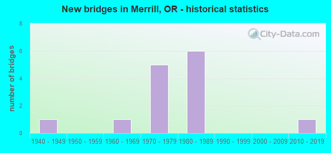
- New bridges - historical statistics
- 11940-1949
- 11960-1969
- 51970-1979
- 61980-1989
- 12010-2019
FCC Registered Cell Phone Towers:
2 (See the full list of FCC Registered Cell Phone Towers in Merrill)FCC Registered Antenna Towers:
17 (See the full list of FCC Registered Antenna Towers)FCC Registered Broadcast Land Mobile Towers:
6- 119 W Front St (Lat: 42.023750 Lon: -121.600000), Call Sign: KQJ82,
Assigned Frequencies: 458.225 MHz, Grant Date: 01/14/2022, Expiration Date: 03/19/2032, Registrant: Oregon Department Of Forestry, 2600 State Street Ne, Salem, OR 97310, Phone: (503) 945-7200, Email:
- 119 W Front St (Lat: 42.025417 Lon: -121.600000), Call Sign: KQL724,
Assigned Frequencies: 453.225 MHz, 453.225 MHz, Grant Date: 09/11/2021, Expiration Date: 12/03/2031, Registrant: Oregon Department Of Forestry, 2600 State Street Ne, Salem, OR 97310, Phone: (503) 945-7200, Email:
- Lat: 42.100139 Lon: -121.635278, Call Sign: KNIS291,
Assigned Frequencies: 461.362 MHz, 466.362 MHz, Grant Date: 12/07/2021, Expiration Date: 02/15/2032, Certifier: Stephen M Plass, Registrant: Plass Communications, 20416 Zlabek Rd., Tulelake, CA 96134, Phone: (530) 667-5167, Email:
- Near Summit Of Stukel Mtn 5 Mi Nw Of (Lat: 42.098750 Lon: -121.635000), Call Sign: WSU888, Licensee ID: L00518215,
Assigned Frequencies: 464.800 MHz, Grant Date: 05/17/2002, Expiration Date: 07/08/2012, Cancellation Date: 09/08/2012, Registrant: J Edgar Osborne, Tulelake, CA 96134, Phone: (916) 667-5151
- Int Falvey & Merrill Pit Rds 1.5 Mi W (Lat: 42.024028 Lon: -121.628889), Call Sign: WST841, Licensee ID: L00077658,
Assigned Frequencies: 153.035 MHz, Grant Date: 01/21/2000, Expiration Date: 03/13/2005, Cancellation Date: 05/14/2005, Registrant: James L Moore, Merrill, OR 97633, Phone: (503) 798-5434
- On Stukel Mtn 5 Mi Nw (Lat: 42.100139 Lon: -121.635278), Type: Gtower, Structure height: 18 m, Overall height: 21 m, Call Sign: KNEX561,
Assigned Frequencies: 451.050 MHz, Grant Date: 01/03/2013, Expiration Date: 03/10/2023, Cancellation Date: 05/13/2023, Registrant: Plass Communications, 20416 Zlabek Rd, Tulelake, CA 96134, Phone: (530) 667-5167, Fax: (530) 667-5168, Email:
FCC Registered Microwave Towers:
4- KENO/HWY 66, Southerly End Of Stukel Mtn, Ne Of Merrill (Lat: 42.096944 Lon: -121.633889), Type: Gtower, Structure height: 30.5 m, Overall height: 35.1 m, Call Sign: WPOR706,
Assigned Frequencies: 6123.10 MHz, 6795.00 MHz, 6004.50 MHz, 6755.00 MHz, 6093.45 MHz, 5974.85 MHz, 11445.0 MHz, 11565.0 MHz, 6152.75 MHz, Grant Date: 01/30/2019, Expiration Date: 02/10/2029, Certifier: John E Rooney, Registrant: Wilkinson Barker Knauer, LLP, 1800 M Street Nw, Suite 800n, Washington, DC 20036, Phone: (202) 383-3420, Fax: (202) 783-5851, Email:
- MERRILL, 455 S. Lincoln St. (Lat: 42.022889 Lon: -121.594444), Type: Ltower, Structure height: 45.7 m, Overall height: 50.3 m, Call Sign: WQEQ392,
Assigned Frequencies: 5960.02 MHz, 6093.45 MHz, 10621.2 MHz, Grant Date: 03/17/2016, Expiration Date: 03/23/2026, Certifier: John E Rooney, Registrant: Wilkinson Barker Knauer, LLP, 1800 M Street Nw, Suite 800n, Washington, DC 20036, Phone: (202) 383-3420, Fax: (202) 783-5851, Email:
- MALIN MERRIL, Approx. 4 Miles E Of Merrill (Lat: 42.026222 Lon: -121.519361), Type: Ltower, Structure height: 27.4 m, Overall height: 28.9 m, Call Sign: WQQK693,
Assigned Frequencies: 10755.0 MHz, 10835.0 MHz, 10875.0 MHz, 10755.0 MHz, 10875.0 MHz, 10755.0 MHz, 10875.0 MHz, 10755.0 MHz, 10875.0 MHz, 10755.0 MHz... (+8 more), Grant Date: 12/13/2022, Expiration Date: 01/15/2033, Certifier: Gregory M Romano, Registrant: Verizon, 5055 North Point Pkwy, Alpharetta, GA 30022, Phone: (770) 797-1070, Email:
- MERRILL RELO, 455 S. Lincoln St. (Lat: 42.022861 Lon: -121.594667), Type: Ltower, Structure height: 45.7 m, Overall height: 50.2 m, Call Sign: WRUS590,
Assigned Frequencies: 10735.0 MHz, 10855.0 MHz, 10735.0 MHz, 10855.0 MHz, 10735.0 MHz, 10855.0 MHz, 10735.0 MHz, 10855.0 MHz, 10735.0 MHz, 10855.0 MHz... (+32 more), Grant Date: 09/28/2022, Expiration Date: 09/28/2032, Cancellation Date: 12/19/2023, Certifier: Christophe Le Scanve, Registrant: Cellco Partnership, 5055 Northpointe Pkwy, Alpharetta, GA 30022, Phone: (770) 797-1070, Email:
FCC Registered Amateur Radio Licenses:
12 (See the full list of FCC Registered Amateur Radio Licenses in Merrill)FAA Registered Aircraft:
1- Aircraft: CESSNA 170A (Category: Land, Seats: 4, Weight: Up to 12,499 Pounds, Speed: 105 mph), Engine: Reciprocating
N-Number: 9910A, N9910A, N-9910A, Serial Number: 19270, Certificate Issue Date: 07/06/2009
Registrant (Co-Owned): Matthew M Shuck, Po Box 177, Merrill, OR 97633, Other Owners: Mary Shuck
| Most common first names in Merrill, OR among deceased individuals | ||
| Name | Count | Lived (average) |
|---|---|---|
| Robert | 14 | 71.7 years |
| James | 14 | 75.4 years |
| John | 12 | 73.0 years |
| William | 12 | 75.7 years |
| Charles | 9 | 72.8 years |
| Mary | 8 | 83.1 years |
| Roy | 6 | 74.3 years |
| Edward | 6 | 75.3 years |
| Paul | 6 | 71.5 years |
| Warren | 5 | 77.0 years |
| Most common last names in Merrill, OR among deceased individuals | ||
| Last name | Count | Lived (average) |
|---|---|---|
| Walker | 9 | 71.5 years |
| Moore | 7 | 75.7 years |
| Haskins | 7 | 74.9 years |
| Nelson | 6 | 75.5 years |
| Brown | 6 | 78.7 years |
| Reed | 5 | 70.4 years |
| Merriman | 5 | 77.2 years |
| Woods | 4 | 79.0 years |
| Hayes | 4 | 81.8 years |
| Heaton | 4 | 69.8 years |
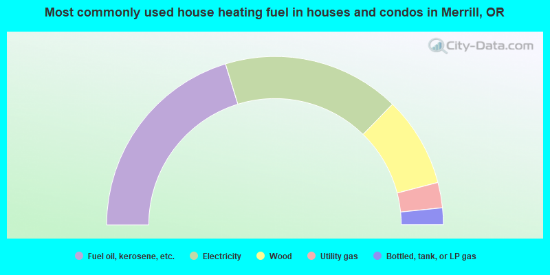
- 40.5%Fuel oil, kerosene, etc.
- 34.1%Electricity
- 17.3%Wood
- 4.9%Utility gas
- 3.2%Bottled, tank, or LP gas
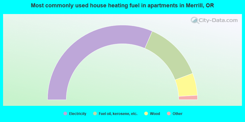
- 64.2%Electricity
- 26.0%Fuel oil, kerosene, etc.
- 9.8%Wood
Merrill compared to Oregon state average:
- Median household income below state average.
- Median house value significantly below state average.
- Black race population percentage above state average.
- Hispanic race population percentage significantly above state average.
- Length of stay since moving in significantly above state average.
- House age above state average.
- Percentage of population with a bachelor's degree or higher significantly below state average.