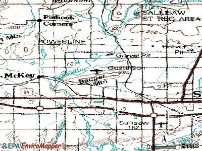
McKey, Oklahoma
Submit your own pictures of this place and show them to the world
- OSM Map
- General Map
- Google Map
- MSN Map

| Males: 72 | |
| Females: 69 |
| Median resident age: | 36.2 years |
| Oklahoma median age: | 35.5 years |
Zip code: 74955
| McKey: | $41,363 |
| OK: | $59,673 |
Estimated per capita income in 2022: $28,329 (it was $15,696 in 2000)
Estimated median house or condo value in 2022: $189,890 (it was $80,600 in 2000)
| McKey: | $189,890 |
| OK: | $191,700 |
Mean prices in 2022: all housing units: $162,208; detached houses: $182,883; townhouses or other attached units: $177,976; in 3-to-4-unit structures: $104,270; mobile homes: $77,817; occupied boats, rvs, vans, etc.: $9,790


- 8462.2%White alone
- 2921.5%American Indian alone
- 2216.3%Two or more races

 Recent articles from our blog. Our writers, many of them Ph.D. graduates or candidates, create easy-to-read articles on a wide variety of topics.

Latest news from McKey, OK collected exclusively by city-data.com from local newspapers, TV, and radio stations
Ancestries: English (18.5%), French (8.9%), German (6.7%), Norwegian (5.9%).
Current Local Time: CST time zone
Elevation: 522 feet
Land area: 5.84 square miles.
Population density: 24 people per square mile (very low).

| McKey CDP: | 0.2% ($199) |
| Oklahoma: | 0.8% ($523) |
Nearest city with pop. 50,000+: Fort Smith, AR  (26.2 miles , pop. 80,268).
Nearest city with pop. 200,000+: Tulsa, OK (76.0 miles , pop. 393,049).
Nearest city with pop. 1,000,000+: Dallas, TX (216.5 miles , pop. 1,188,580).
Nearest cities:
), )Latitude: 35.48 N, Longitude: 94.84 W
Area code commonly used in this area: 918


| Here: | 3.8% |
| Oklahoma: | 3.2% |
Average climate in McKey, Oklahoma
Based on data reported by over 4,000 weather stations


(lower is better)

Air Quality Index (AQI) level in 2022 was 79.1. This is about average.
| City: | 79.1 |
| U.S.: | 72.6 |

Carbon Monoxide (CO) [ppm] level in 2022 was 0.243. This is about average. Closest monitor was 20.8 miles away from the city center.
| City: | 0.243 |
| U.S.: | 0.251 |

Nitrogen Dioxide (NO2) [ppb] level in 2022 was 5.23. This is about average. Closest monitor was 6.7 miles away from the city center.
| City: | 5.23 |
| U.S.: | 5.11 |

Sulfur Dioxide (SO2) [ppb] level in 2022 was 0.305. This is significantly better than average. Closest monitor was 20.8 miles away from the city center.
| City: | 0.305 |
| U.S.: | 1.515 |

Ozone [ppb] level in 2022 was 30.2. This is about average. Closest monitor was 6.7 miles away from the city center.
| City: | 30.2 |
| U.S.: | 33.3 |

Particulate Matter (PM10) [µg/m3] level in 2022 was 16.4. This is about average. Closest monitor was 6.7 miles away from the city center.
| City: | 16.4 |
| U.S.: | 19.2 |

Particulate Matter (PM2.5) [µg/m3] level in 2022 was 6.98. This is about average. Closest monitor was 6.7 miles away from the city center.
| City: | 6.98 |
| U.S.: | 8.11 |
Tornado activity:
McKey-area historical tornado activity is slightly below Oklahoma state average. It is 111% greater than the overall U.S. average.
On 3/26/1976, a category F5 (max. wind speeds 261-318 mph) tornado 21.2 miles away from the McKey place center killed 2 people and injured 64 people and caused between $500,000 and $5,000,000 in damages.
On 5/5/1960, a category F4 (max. wind speeds 207-260 mph) tornado 2.7 miles away from the place center killed 16 people and injured 106 people and caused between $500,000 and $5,000,000 in damages.
Earthquake activity:
McKey-area historical earthquake activity is significantly above Oklahoma state average. It is 663% greater than the overall U.S. average.On 11/6/2011 at 03:53:10, a magnitude 5.7 (5.7 MW, Depth: 3.2 mi, Class: Moderate, Intensity: VI - VII) earthquake occurred 108.3 miles away from the city center
On 9/3/2016 at 12:02:44, a magnitude 5.8 (5.8 MW, Depth: 3.5 mi) earthquake occurred 133.8 miles away from McKey center
On 11/7/2016 at 01:44:24, a magnitude 5.0 (5.0 MW, Depth: 2.8 mi) earthquake occurred 115.5 miles away from McKey center
On 11/5/2011 at 07:12:45, a magnitude 4.8 (4.8 MW, Depth: 1.9 mi, Class: Light, Intensity: IV - V) earthquake occurred 108.3 miles away from the city center
On 11/8/2011 at 02:46:57, a magnitude 4.8 (4.8 MW, Depth: 3.1 mi) earthquake occurred 109.6 miles away from the city center
On 2/28/2011 at 05:00:50, a magnitude 4.7 (4.7 MW, Depth: 2.0 mi) earthquake occurred 141.1 miles away from the city center
Magnitude types: moment magnitude (MW)
Natural disasters:
The number of natural disasters in Sequoyah County (26) is a lot greater than the US average (15).Major Disasters (Presidential) Declared: 17
Emergencies Declared: 6
Causes of natural disasters: Floods: 15, Storms: 14, Winter Storms: 10, Tornadoes: 9, Winds: 2, Hurricane: 1, Snow: 1, Other: 1 (Note: some incidents may be assigned to more than one category).
Hospitals and medical centers near McKey:
- SEQUOYAH MEMORIAL HOSPITAL HOME HEALTH (Home Health Center, about 4 miles away; SALLISAW, OK)
- SEQUOYAH MEMORIAL HOSPITAL Acute Care Hospitals (about 4 miles away; SALLISAW, OK)
- SOUTHWEST HOME HEALTH CARE (Home Health Center, about 4 miles away; SALLISAW, OK)
- LOCAL HOSPICE, INC (Hospital, about 4 miles away; SALLISAW, OK)
- PROFESSIONAL HOME HEALTH (Home Health Center, about 4 miles away; SALLISAW, OK)
- SEQUOYAH MANOR, LLC (Nursing Home, about 4 miles away; SALLISAW, OK)
- PETERS AGENCY HOME HEALTH SERVICES, L L C (Home Health Center, about 4 miles away; SALLISAW, OK)
Colleges/universities with over 2000 students nearest to McKey:
- University of Arkansas-Fort Smith (about 28 miles; Fort Smith, AR; Full-time enrollment: 6,103)
- Northeastern State University (about 32 miles; Tahlequah, OK; FT enrollment: 6,895)
- Carl Albert State College (about 34 miles; Poteau, OK; FT enrollment: 2,041)
- John Brown University (about 52 miles; Siloam Springs, AR; FT enrollment: 2,097)
- University of Arkansas (about 55 miles; Fayetteville, AR; FT enrollment: 22,163)
- Oklahoma State University Institute of Technology (about 63 miles; Okmulgee, OK; FT enrollment: 3,243)
- NorthWest Arkansas Community College (about 72 miles; Bentonville, AR; FT enrollment: 5,634)
Points of interest:
Notable location: Blue Ribbon Downs (A). Display/hide its location on the map
Reservoir: Sallisaw Creek Site 4 Reservoir (A). Display/hide its location on the map
| This place: | 2.5 people |
| Oklahoma: | 2.5 people |
| This place: | 69.1% |
| Whole state: | 69.1% |
| This place: | 1.8% |
| Whole state: | 4.0% |
Likely homosexual households (counted as self-reported same-sex unmarried-partner households)
- Lesbian couples: 1.8% of all households
- Gay men: 0.0% of all households
For population 15 years and over in McKey:

- Never married: 7.8%
- Now married: 63.1%
- Separated: 0.0%
- Widowed: 10.7%
- Divorced: 18.4%
For population 25 years and over in McKey:
- High school or higher: 56.6%
- Bachelor's degree or higher: 0.0%
- Graduate or professional degree: 0.0%
- Mean travel time to work (commute): 71.7 minutes


| Here: | 7.8 |
| Oklahoma average: | 11.7 |
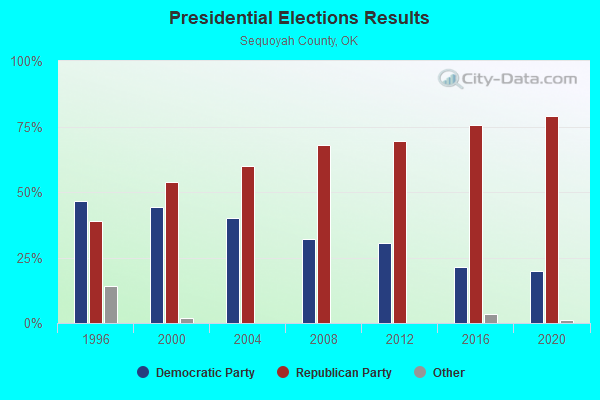
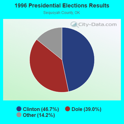
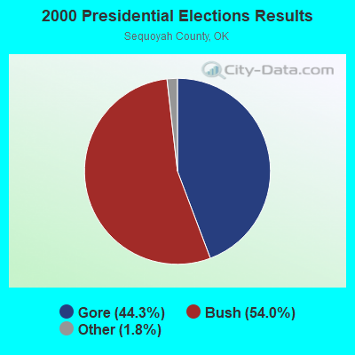
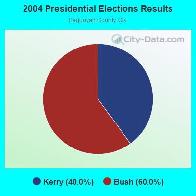
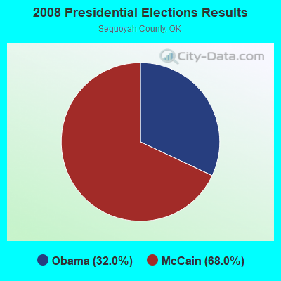
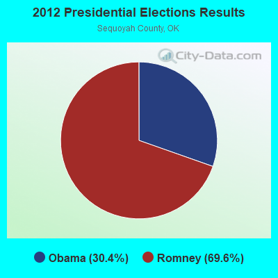
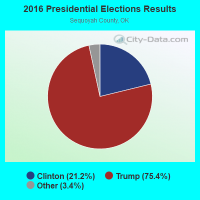
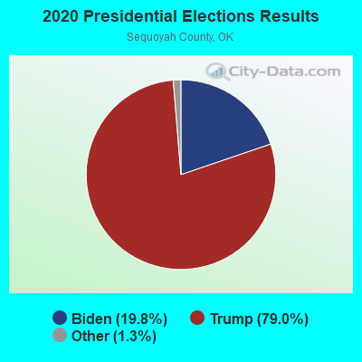
Graphs represent county-level data. Detailed 2008 Election Results
Religion statistics for McKey, OK (based on Sequoyah County data)
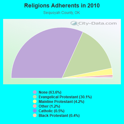
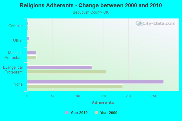
| Religion | Adherents | Congregations |
|---|---|---|
| Evangelical Protestant | 12,746 | 75 |
| Mainline Protestant | 1,791 | 6 |
| Other | 492 | 3 |
| Catholic | 220 | 2 |
| Black Protestant | 187 | 1 |
| None | 26,955 | - |
Food Environment Statistics:
| Sequoyah County: | 1.95 / 10,000 pop. |
| State: | 1.97 / 10,000 pop. |
| Here: | 0.24 / 10,000 pop. |
| State: | 0.20 / 10,000 pop. |
| Sequoyah County: | 0.73 / 10,000 pop. |
| Oklahoma: | 0.76 / 10,000 pop. |
| This county: | 5.86 / 10,000 pop. |
| Oklahoma: | 4.35 / 10,000 pop. |
| Here: | 4.89 / 10,000 pop. |
| State: | 6.89 / 10,000 pop. |
| Sequoyah County: | 11.9% |
| State: | 10.3% |
| Sequoyah County: | 31.6% |
| State: | 29.2% |
Strongest AM radio stations in McKey:
- KYHN (1320 AM; 10 kW; FORT SMITH, AR; Owner: CAPSTAR TX LIMITED PARTNERSHIP)
- KFAQ (1170 AM; 50 kW; TULSA, OK; Owner: JOURNAL BROADCAST CORPORATION)
- KWHN (1650 AM; 10 kW; FT. SMITH, AR; Owner: CAPSTAR TX LIMITED PARTNERSHIP)
- KRMG (740 AM; 50 kW; TULSA, OK; Owner: CXR HOLDINGS, INC.)
- KKUZ (1560 AM; daytime; 0 kW; SALLISAW, OK; Owner: TEDDY BEAR COMMUNICATIONS, INC.)
- KFAY (1030 AM; 10 kW; FARMINGTON, AR; Owner: CUMULUS LICENSING CORP)
- KTBZ (1430 AM; 25 kW; TULSA, OK; Owner: CLEAR CHANNEL BROADCASTING LICENSES, INC.)
- KGHT (880 AM; 50 kW; SHERIDAN, AR; Owner: METROPOLITAN RADIO GROUP, INC.)
- KFSA (950 AM; 1 kW; FORT SMITH, AR; Owner: FRED H. BAKER, SR.)
- KMUS (1380 AM; 20 kW; MUSKOGEE, OK; Owner: ABC, INC.)
- KAAY (1090 AM; 50 kW; LITTLE ROCK, AR; Owner: CITADEL BROADCASTING COMPANY)
- KEEL (710 AM; 50 kW; SHREVEPORT, LA; Owner: CITICASTERS LICENSES, L.P.)
- KUOA (1290 AM; 5 kW; SILOAM SPRINGS, AR; Owner: KUOA, INC.)
Strongest FM radio stations in McKey:
- KKBD (95.9 FM; SALLISAW, OK; Owner: CAPSTAR TX LIMITED PARTNERSHIP)
- KZBB (97.9 FM; POTEAU, OK; Owner: CAPSTAR TX LIMITED PARTNERSHIP)
- KMAG (99.1 FM; FORT SMITH, AR; Owner: CAPSTAR TX LIMITED PARTNERSHIP)
- KTCS-FM (99.9 FM; FORT SMITH, AR; Owner: BIG CHIEF BROADCASTING COMPANY)
- K204EW (88.7 FM; POTEAU, OK; Owner: CALVARY CHAPEL OF TWIN FALLS, INC.)
- K219CN (91.7 FM; POTEAU, OK; Owner: AMERICAN FAMILY ASSOCIATION)
- KARG (91.7 FM; POTEAU, OK; Owner: AMERICAN FAMILY ASSOCIATION)
- KISR (93.7 FM; FORT SMITH, AR; Owner: STEREO 93, INC.)
- KREU (92.3 FM; ROLAND, OK; Owner: STAR 92 CO.)
- KOMS (107.3 FM; POTEAU, OK; Owner: CUMULUS LICENSING CORP.)
- KTKL (88.5 FM; STIGLER, OK; Owner: EDUCATIONAL MEDIA FOUNDATION)
- KMMY (97.1 FM; MUSKOGEE, OK; Owner: KMMY, Inc.)
- KDAB (94.9 FM; PRAIRIE GROVE, AR; Owner: CUMULUS LICENSING CORP.)
- KLSZ-FM (102.7 FM; VAN BUREN, AR; Owner: CUMULUS LICENSING CORP.)
- KAOW (88.9 FM; FORT SMITH, AR; Owner: AMERICAN FAMILY ASSOCIATION)
- K209CA (89.7 FM; VAN BUREN, AR; Owner: BIBLE BROADCASTING NETWORK, INC.)
TV broadcast stations around McKey:
- KFSM-TV (Channel 5; FORT SMITH, AR; Owner: NEW YORK TIMES MANAGEMENT SERVICES)
- KTUL (Channel 8; TULSA, OK; Owner: KTUL, LLC)
- K48FL (Channel 48; FORT SMITH, AR; Owner: TV 34, INC.)
- KOTV (Channel 6; TULSA, OK; Owner: GRIFFIN LICENSING, L.L.C.)
| Home Mortgage Disclosure Act Aggregated Statistics For Year 2009 (Based on 1 partial tract) | ||
| C) Refinancings | ||
|---|---|---|
| Number | Average Value | |
| LOANS ORIGINATED | 1 | $102,650 |
| APPLICATIONS APPROVED, NOT ACCEPTED | 0 | $0 |
| APPLICATIONS DENIED | 0 | $0 |
| APPLICATIONS WITHDRAWN | 0 | $0 |
| FILES CLOSED FOR INCOMPLETENESS | 0 | $0 |
Detailed HMDA statistics for the following Tracts: 0301.01


McKey compared to Oklahoma state average:
- Unemployed percentage significantly below state average.
- Black race population percentage significantly below state average.
- Hispanic race population percentage significantly below state average.
- Foreign-born population percentage significantly below state average.
- Renting percentage significantly below state average.
- Length of stay since moving in significantly above state average.
- Number of rooms per house significantly below state average.
- House age significantly below state average.
- Number of college students significantly below state average.
- Percentage of population with a bachelor's degree or higher significantly below state average.
McKey on our top lists:
- #37 on the list of "Top 101 larger cities with the lowest real estate taxes percentage (population 50,000+)"
- #8 on the list of "Top 101 counties with the highest percentage of residents that smoked 100+ cigarettes in their lives"
- #9 on the list of "Top 101 counties with the highest percentage of residents that drank alcohol in the past 30 days"
- #17 on the list of "Top 101 counties with the lowest percentage of residents that exercised in the past month"
- #19 on the list of "Top 101 counties with the worst general health status score of residents (1-5), 3 years of data"
- #72 on the list of "Top 101 counties with the lowest Nitrogen Dioxide air pollution readings in 2012 (ppm)"