McClave, Colorado
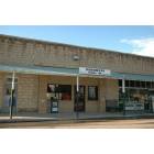
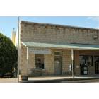
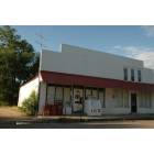
McClave: McClave Store
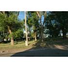
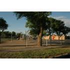
McClave: McClave Park
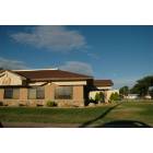
McClave: McClave Bank
McClave: McClave School
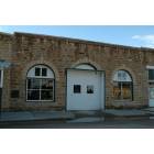
McClave: McClave Post Office
McClave: McClave Gas
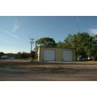
McClave: McClave Fire Dept
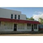
McClave: McClave Business
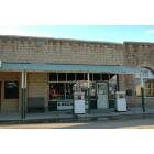
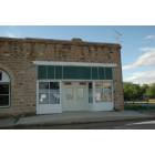
McClave: McClave Store
McClave: McClave Business
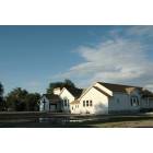
McClave: McClave Church
McClave: McClave Business
- add
your
Submit your own pictures of this place and show them to the world
- OSM Map
- General Map
- Google Map
- MSN Map

| Males: 466 | |
| Females: 466 |
| Median resident age: | 34.5 years |
| Colorado median age: | 34.3 years |
Zip code: 81057
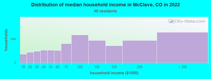
| McClave: | $57,729 |
| CO: | $89,302 |
Estimated per capita income in 2022: $22,126 (it was $15,211 in 2000)
McClave CCD income, earnings, and wages data
Estimated median house or condo value in 2022: $163,461 (it was $75,000 in 2000)
| McClave: | $163,461 |
| CO: | $531,100 |
Mean prices in 2022: all housing units: $135,138; detached houses: $145,869; mobile homes: $72,481
Detailed information about poverty and poor residents in McClave, CO


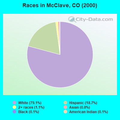
- 76179.1%White alone
- 18018.7%Hispanic
- 111.1%Two or more races
- 80.8%Asian alone
- 10.1%Black alone
- 10.1%American Indian alone
According to our research of Colorado and other state lists, there were 3 registered sex offenders living in McClave, Colorado as of May 11, 2024.
The ratio of all residents to sex offenders in McClave is 311 to 1.
 Recent articles from our blog. Our writers, many of them Ph.D. graduates or candidates, create easy-to-read articles on a wide variety of topics.
Current Local Time: MST time zone
Elevation: 3860 feet
Land area: 263.5 square miles.
Population density: 3.5 people per square mile (very low).

| McClave CCD: | 0.6% ($440) |
| Colorado: | 0.7% ($1,132) |
Nearest city with pop. 50,000+: Pueblo, CO  (96.1 miles , pop. 102,121).
Nearest city with pop. 200,000+: Colorado Springs, CO (116.0 miles , pop. 360,890).
Nearest city with pop. 1,000,000+: Dallas, TX (503.0 miles , pop. 1,188,580).
Nearest cities:
), Latitude: 38.14 N, Longitude: 102.86 W
Area code commonly used in this area: 719

| Here: | 2.6% |
| Colorado: | 3.2% |
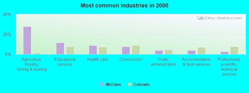
- Agriculture, forestry, fishing & hunting (27.9%)
- Educational services (11.8%)
- Health care (9.0%)
- Construction (7.7%)
- Public administration (4.2%)
- Accommodation & food services (4.2%)
- Professional, scientific, technical services (2.9%)
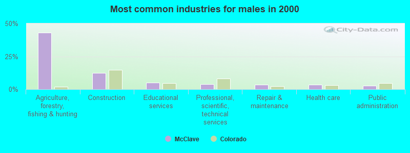
- Agriculture, forestry, fishing & hunting (43.1%)
- Construction (12.3%)
- Educational services (5.1%)
- Professional, scientific, technical services (4.0%)
- Repair & maintenance (3.6%)
- Health care (3.6%)
- Public administration (2.8%)
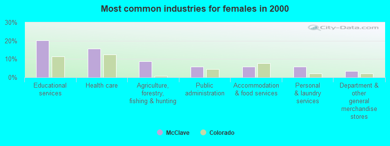
- Educational services (20.2%)
- Health care (15.8%)
- Agriculture, forestry, fishing & hunting (8.9%)
- Public administration (5.9%)
- Accommodation & food services (5.9%)
- Personal & laundry services (5.9%)
- Department & other general merchandise stores (3.4%)
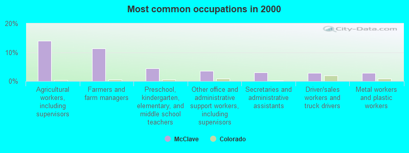
- Agricultural workers, including supervisors (14.0%)
- Farmers and farm managers (11.4%)
- Preschool, kindergarten, elementary, and middle school teachers (4.4%)
- Other office and administrative support workers, including supervisors (3.5%)
- Secretaries and administrative assistants (3.1%)
- Driver/sales workers and truck drivers (2.9%)
- Metal workers and plastic workers (2.9%)
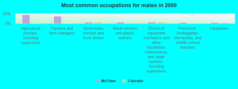
- Agricultural workers, including supervisors (21.7%)
- Farmers and farm managers (18.2%)
- Driver/sales workers and truck drivers (4.0%)
- Metal workers and plastic workers (4.0%)
- Electrical equipment mechanics and other installation, maintenance, and repair workers, including supervisors (4.0%)
- Preschool, kindergarten, elementary, and middle school teachers (2.8%)
- Carpenters (2.8%)
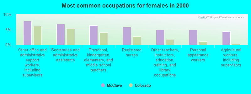
- Other office and administrative support workers, including supervisors (7.9%)
- Secretaries and administrative assistants (6.9%)
- Preschool, kindergarten, elementary, and middle school teachers (6.4%)
- Registered nurses (5.9%)
- Other teachers, instructors, education, training, and library occupations (4.9%)
- Personal appearance workers (4.9%)
- Agricultural workers, including supervisors (4.4%)
Average climate in McClave, Colorado
Based on data reported by over 4,000 weather stations


Tornado activity:
McClave-area historical tornado activity is near Colorado state average. It is 31% smaller than the overall U.S. average.
On 5/29/2001, a category F3 (max. wind speeds 158-206 mph) tornado 11.7 miles away from the McClave place center caused $150,000 in damages.
On 10/17/1971, a category F3 tornado 16.6 miles away from the place center caused between $50,000 and $500,000 in damages.
Earthquake activity:
McClave-area historical earthquake activity is significantly above Colorado state average. It is 624% greater than the overall U.S. average.On 8/23/2011 at 05:46:18, a magnitude 5.3 (5.3 MW, Depth: 2.5 mi, Class: Moderate, Intensity: VI - VII) earthquake occurred 125.2 miles away from the city center
On 8/18/1959 at 06:37:13, a magnitude 7.7 (7.7 UK, Class: Major, Intensity: VIII - XII) earthquake occurred 600.8 miles away from McClave center, causing $26,000,000 total damage
On 8/10/2005 at 22:08:22, a magnitude 5.0 (5.0 MB, 4.7 MS, 5.0 MW) earthquake occurred 134.2 miles away from McClave center
On 8/10/2005 at 22:08:22, a magnitude 5.0 (5.0 MW, Depth: 3.1 mi) earthquake occurred 135.9 miles away from the city center
On 8/22/2011 at 23:30:19, a magnitude 4.7 (4.7 MW, Depth: 3.1 mi, Class: Light, Intensity: IV - V) earthquake occurred 120.2 miles away from the city center
On 9/3/2016 at 12:02:44, a magnitude 5.8 (5.8 MW, Depth: 3.5 mi) earthquake occurred 347.1 miles away from McClave center
Magnitude types: body-wave magnitude (MB), surface-wave magnitude (MS), moment magnitude (MW)
Natural disasters:
The number of natural disasters in Bent County (8) is smaller than the US average (15).Major Disasters (Presidential) Declared: 4
Emergencies Declared: 3
Causes of natural disasters: Storms: 3, Floods: 2, Drought: 1, Fire: 1, Hurricane: 1, Landslide: 1, Mudslide: 1, Snow: 1, Tornado: 1, Other: 1 (Note: some incidents may be assigned to more than one category).
Hospitals and medical centers near McClave:
- JUNIPER VILLAGE AT LAMAR (Nursing Home, about 14 miles away; LAMAR, CO)
- LAMAR AREA HOSPICE ASSOCIATION (Hospital, about 14 miles away; LAMAR, CO)
- LAMAR DIALYSIS (FMC) (Dialysis Facility, about 14 miles away; LAMAR, CO)
- PROWERS MEDICAL CENTER HOME HEALTH (Home Health Center, about 15 miles away; LAMAR, CO)
- PROWERS MEDICAL CENTER Critical Access Hospitals (about 15 miles away; LAMAR, CO)
Colleges/universities with over 2000 students nearest to McClave:
- Colorado State University-Pueblo (about 95 miles; Pueblo, CO; Full-time enrollment: 5,993)
- Pueblo Community College (about 97 miles; Pueblo, CO; FT enrollment: 5,329)
- Pikes Peak Community College (about 114 miles; Colorado Springs, CO; FT enrollment: 10,395)
- Colorado College (about 118 miles; Colorado Springs, CO; FT enrollment: 2,199)
- University of Colorado Colorado Springs (about 118 miles; Colorado Springs, CO; FT enrollment: 8,700)
- Colorado Technical University-Online (about 119 miles; Colorado Springs, CO; FT enrollment: 22,771)
- Colorado Technical University-Colorado Springs (about 119 miles; Colorado Springs, CO; FT enrollment: 2,049)
Public high school in McClave:
- MC CLAVE UNDIVIDED HIGH SCHOOL (Students: 117, Location: 308 LINCOLN STREET, Grades: 7-12)
Public elementary/middle school in McClave:
- MC CLAVE ELEMENTARY SCHOOL (Students: 149, Location: 308 LINCOLN STREET, Grades: PK-6)
Points of interest:
Notable locations in McClave: Cordes-Oberlander Ranch (A), Bishop Ranch (B), Hasty - McClave Fire Department (C). Display/hide their locations on the map
Churches in McClave include: Friends Community Church of Hasty (A), Methodist Church of McClave (B), Riverview Church (C). Display/hide their locations on the map
Cemeteries: Union Valley Cemetery (1), Wiley Cemetery (2), The Home Cemetery (3). Display/hide their locations on the map
Lakes and reservoirs: Long Lake (A), Jims Pond (B), Lake Hasty (C), Dingwall Ditch Retention Reservoir (D), G W Verhoeff Reservoir (E), John Martin Reservoir (F). Display/hide their locations on the map
Streams, rivers, and creeks: Limestone Creek (A), McRae Arroyo (B), Prowers Arroyo (C), Graveyard Creek (D). Display/hide their locations on the map
Parks in McClave include: Bents New Fort Marker (1), John Martin Reservoir Wildlife Area (2). Display/hide their locations on the map
Drinking water stations with addresses in McClave and their reported violations in the past:
MCCLAVE WA INC (Population served: 440, Groundwater):Past monitoring violations:
- 33 regular monitoring violations
| This place: | 2.5 people |
| Colorado: | 2.5 people |
| This place: | 73.2% |
| Whole state: | 63.9% |
| This place: | 3.7% |
| Whole state: | 6.5% |
No gay or lesbian households reported
| This place: | 14.9% |
| Whole state: | 9.3% |
| This place: | 6.5% |
| Whole state: | 4.1% |
For population 15 years and over in McClave:
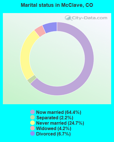
- Never married: 24.7%
- Now married: 64.4%
- Separated: 2.2%
- Widowed: 4.2%
- Divorced: 6.7%
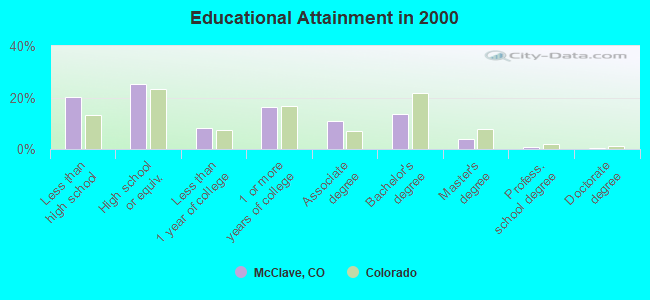
For population 25 years and over in McClave:
- High school or higher: 79.6%
- Bachelor's degree or higher: 18.8%
- Graduate or professional degree: 5.3%
- Unemployed: 1.1%
- Mean travel time to work (commute): 18.2 minutes
| Here: | 12.6 |
| Colorado average: | 11.8 |
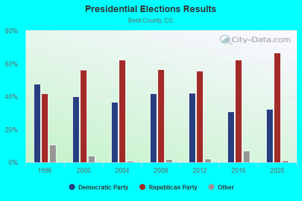
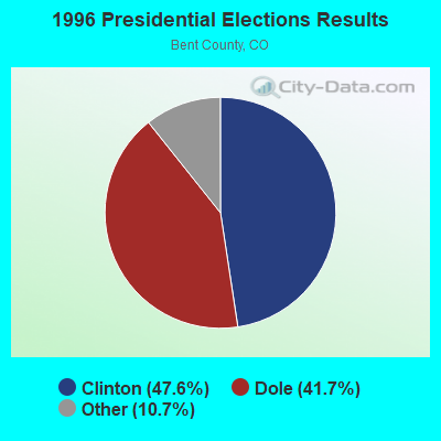
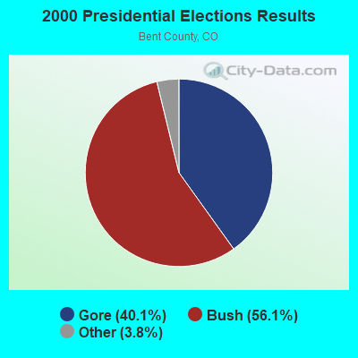
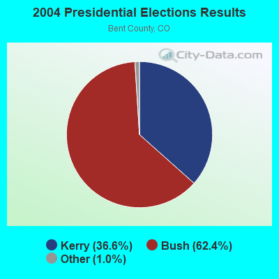
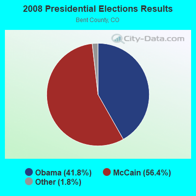
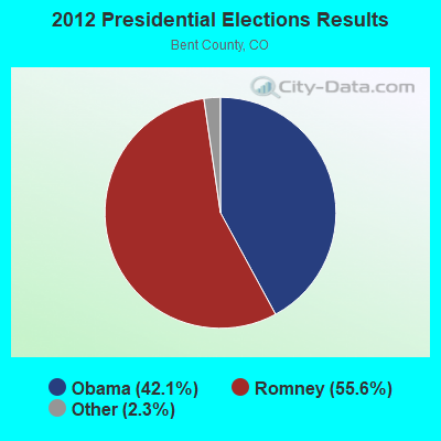
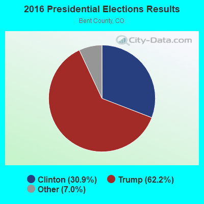
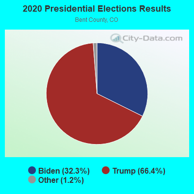
Graphs represent county-level data. Detailed 2008 Election Results
Religion statistics for McClave, CO (based on Bent County data)
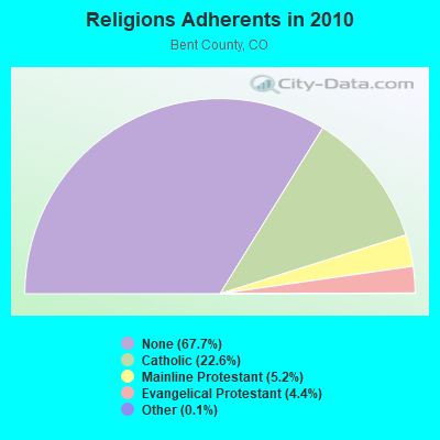
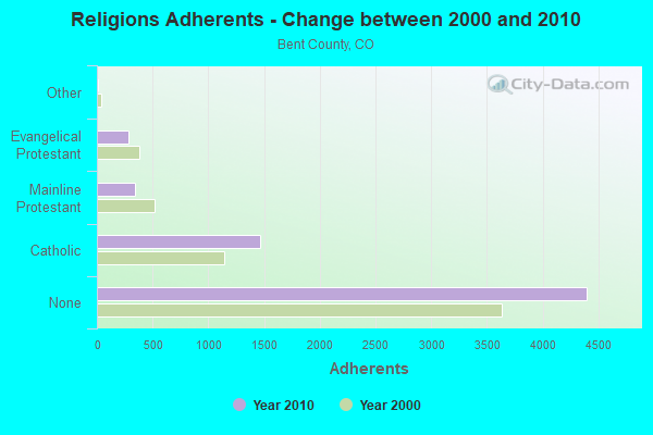
| Religion | Adherents | Congregations |
|---|---|---|
| Catholic | 1,469 | 1 |
| Mainline Protestant | 338 | 3 |
| Evangelical Protestant | 285 | 9 |
| Other | 7 | - |
| None | 4,400 | - |
Food Environment Statistics:
| This county: | 3.41 / 10,000 pop. |
| Colorado: | 1.50 / 10,000 pop. |
| Bent County: | 5.11 / 10,000 pop. |
| State: | 3.13 / 10,000 pop. |
| Bent County: | 10.22 / 10,000 pop. |
| State: | 8.99 / 10,000 pop. |
| Here: | 5.7% |
| State: | 5.3% |
| This county: | 21.7% |
| State: | 18.4% |
| This county: | 14.5% |
| Colorado: | 9.6% |
Strongest AM radio stations in McClave:
- KLMR (920 AM; 5 kW; LAMAR, CO; Owner: COMMONWEALTH LICENSE SUBSIDIARY, LLC)
- KOA (850 AM; 50 kW; DENVER, CO; Owner: JACOR BROADCASTING OF COLORADO, INC.)
- KLTT (670 AM; 50 kW; COMMERCE CITY, CO; Owner: KLZ RADIO, INC.)
- KGYN (1210 AM; 50 kW; GUYMON, OK; Owner: TELNS BROADCASTING COMPANY, INC.)
- KMXA (1090 AM; 50 kW; AURORA, CO; Owner: ENTRAVISION HOLDINGS, LLC)
- KKZN (760 AM; 50 kW; THORNTON, CO; Owner: JACOR BROADCASTING OF COLORADO, INC.)
- KCBR (1040 AM; daytime; 15 kW; MONUMENT, CO; Owner: KLZ RADIO, INC.)
- KKOB (770 AM; 50 kW; ALBUQUERQUE, NM; Owner: CITADEL BROADCASTING COMPANY)
- KSIR (1010 AM; 25 kW; BRUSH, CO; Owner: JMS BROADCASTING, LLC)
- KRVN (880 AM; 50 kW; LEXINGTON, NE; Owner: NEBRASKA RURAL RADIO ASSOCIATION)
- KIMB (1260 AM; 50 kW; KIMBALL, NE; Owner: G & L INVESTMENTS, LLC)
- KLMO (1060 AM; 30 kW; LONGMONT, CO; Owner: PILGRIM COMMUNICATIONS, INC.)
- KCMN (1530 AM; 15 kW; COLORADO SPRINGS, CO)
Strongest FM radio stations in McClave:
- KVAY (105.7 FM; LAMAR, CO; Owner: BEACON BROADCASTING LLC)
- KSNZ (93.3 FM; LAMAR, CO; Owner: COMMONWEALTH LICENSE SUBSIDIARY, LLC)
- K211EI (90.1 FM; LAMAR, CO; Owner: CALVARY CHAPEL OF TWIN FALLS, INC.)
- K207BI (89.3 FM; LAMAR, CO; Owner: MAKE A DIFFERENCE FOUNDATION, INC.)
TV broadcast stations around McClave:
- K48DW (Channel 48; EADS, ETC., CO; Owner: KIOWA COUNTY)
- K07DH (Channel 7; LAMAR, CO; Owner: THE CITY OF LAMAR, COLORADO)
FCC Registered Antenna Towers:
6- Matthew Harbeck, Colorado Highway 196 (Lat: 38.135944 Lon: -102.853278), Type: 28.6, Structure height: 08011 m, Overall height: 27.4 m, Registrant: Industrial Tower West LLC, Jon.Becker@viaero.Com, , Fort -Morgan, Phone: (970) 542-3199
- Matthew Harbeck, Colorado Highway 196 (Lat: 38.135944 Lon: -102.853278), Type: 28.6, Structure height: 08011 m, Overall height: 27.4 m, Registrant: Industrial Tower West LLC, Jon.Becker@viaero.Com, , Fort -Morgan, Phone: (970) 542-3199
- Jon Becker, Colorado Highway 196 (Lat: 38.135944 Lon: -102.853278), Type: 28.6, Structure height: 08011 m, Overall height: 27.4 m, Registrant: Industrial Tower West LLC, Siteacq@viaero.Com, , Fort -Morgan, Phone: (970) 467-3199
- Jon Becker, Colorado Highway 196 (Lat: 38.135944 Lon: -102.853278), Type: 28.6, Structure height: 08011 m, Overall height: 27.4 m, Registrant: Industrial Tower West LLC, Siteacq@viaero.Com, , Fort -Morgan, Phone: (970) 467-3199
- Jon Becker, Colorado Highway 196 (Lat: 38.135944 Lon: -102.853278), Type: 29.0, Structure height: 08011 m, Overall height: 27.4 m, Registrant: Industrial Tower West LLC, Siteacq@viaero.Com, , Fort -Morgan, Phone: (970) 467-3199
- Jon Becker, Colorado Highway 196 (Lat: 38.135944 Lon: -102.853278), Type: 29.0, Structure height: 08011 m, Overall height: 27.4 m, Registrant: Industrial Tower West LLC, Siteacq@viaero.Com, , Fort -Morgan, Phone: (970) 467-3199
FCC Registered Broadcast Land Mobile Towers:
4- .5 Mi N .25 Mi E Jct Hwy 196 & Main St (Lat: 38.139167 Lon: -102.727694), Call Sign: KCX934, Licensee ID: L00411395,
Assigned Frequencies: 152.885 MHz, Grant Date: 10/18/2001, Expiration Date: 11/03/2011, Cancellation Date: 01/07/2012, Registrant: Joe Kasza, Box 13, Mcclave, CO 81057, Phone: (719) 829-4208
- 23133 Road Ll (Lat: 38.141944 Lon: -102.786028), Call Sign: KNEP331,
Assigned Frequencies: 152.975 MHz, Grant Date: 01/23/1998, Expiration Date: 03/03/2003, Cancellation Date: 06/08/2003, Registrant: Steven R Wertz, 34244 Rd Llk, Mcglave, CO 81057
- 2 Mi N Cr 30 (Lat: 38.164167 Lon: -102.851861), Call Sign: KCJ732, Licensee ID: L00055404,
Assigned Frequencies: 158.160 MHz, Grant Date: 05/12/2005, Expiration Date: 07/23/2015, Cancellation Date: 09/26/2015, Registrant: Fort Lyon Canal Company, Las Animas, CO 81054, Phone: (719) 456-0720
- MCCLAVE SCHOOL DIST., 308 Lincoln Ave (Lat: 38.137861 Lon: -102.849889), Call Sign: WRDM236,
Assigned Frequencies: 452.000 MHz, 452.200 MHz, 452.300 MHz, 469.950 MHz, 452.112 MHz, 457.112 MHz, Grant Date: 06/03/2019, Expiration Date: 06/03/2029, Certifier: Terry Weber, Registrant: Communication Solutions Inc., 1110 Elkton Dr Suite J, Colorado Springs, CO 80907, Phone: (719) 578-8435, Fax: (719) 520-1274, Email:
FCC Registered Microwave Towers:
4- McClave School, Lat: 38.135944 Lon: -102.853278, Type: Mtower, Structure height: 27.4 m, Call Sign: WQUP435,
Assigned Frequencies: 3650.00 MHz, Grant Date: 09/03/2014, Expiration Date: 09/03/2024, Cancellation Date: 01/03/2023, Certifier: Thomas W Burnett, Registrant: Ne Colorado Cellular, Inc., 1224 West Platte Avenue, Fort Morgan, CO 80701, Phone: (970) 542-3667, Fax: (970) 867-3589, Email:
- McClave School, Lat: 38.135944 Lon: -102.853278, Type: Mtower, Structure height: 27.4 m, Call Sign: WQUP435,
Assigned Frequencies: 3650.00 MHz, Grant Date: 09/03/2014, Expiration Date: 09/03/2024, Cancellation Date: 01/03/2023, Certifier: Thomas W Burnett, Registrant: Ne Colorado Cellular, Inc., 1224 West Platte Avenue, Fort Morgan, CO 80701, Phone: (970) 542-3667, Fax: (970) 867-3589, Email:
- MCCLAVE, 99 Highway 196 (Lat: 38.135944 Lon: -102.853278), Type: Mtower, Structure height: 27.4 m, Call Sign: WQVS250,
Assigned Frequencies: 11505.0 MHz, 11545.0 MHz, 11365.0 MHz, Grant Date: 04/27/2015, Expiration Date: 04/27/2025, Certifier: Thomas W Burnett, Registrant: Ne Colorado Cellular, Inc., 1220 West Platte Ave, Fort Morgan, CO 80701, Phone: (970) 867-6767, Fax: (970) 867-3589, Email:
FAA Registered Aircraft:
1- Aircraft: CHAMPION 7FC (Category: Land, Seats: 2, Weight: Up to 12,499 Pounds, Speed: 90 mph), Engine: CONT MOTOR C90 SERIES (95 HP) (Reciprocating)
N-Number: 4839E, N4839E, N-4839E, Serial Number: 7FC-296, Year manufactured: 1959, Airworthiness Date: 01/23/1959, Certificate Issue Date: 01/05/1999
Registrant (Individual): Burt W Heckman, 28274 Rd Ll, Mcclave, CO 81057
2006 - 2018 National Fire Incident Reporting System (NFIRS) incidents
- Fire incident types reported to NFIRS in McClave, CO
- 8779.8%Outside Fires
- 109.2%Structure Fires
- 76.4%Mobile Property/Vehicle Fires
- 54.6%Other
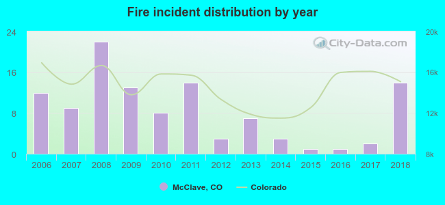 Based on the data from the years 2006 - 2018 the average number of fire incidents per year is 8. The highest number of fires - 22 took place in 2008, and the least - 1 in 2015. The data has a growing trend.
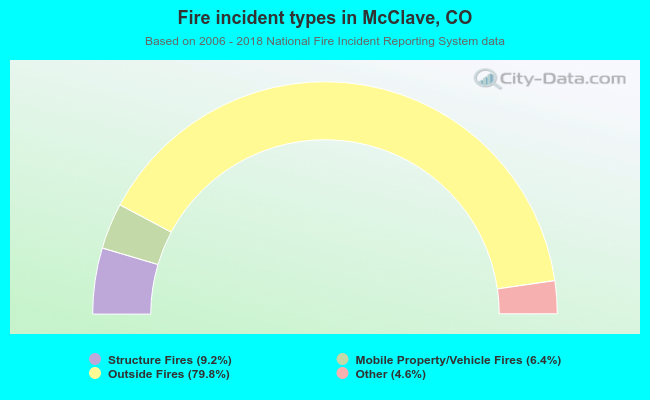 When looking into fire subcategories, the most reports belonged to: Outside Fires (79.8%), and Structure Fires (9.2%).
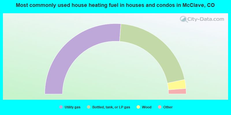
- 52.5%Utility gas
- 41.0%Bottled, tank, or LP gas
- 4.1%Wood
- 1.6%Electricity
- 0.8%Other fuel
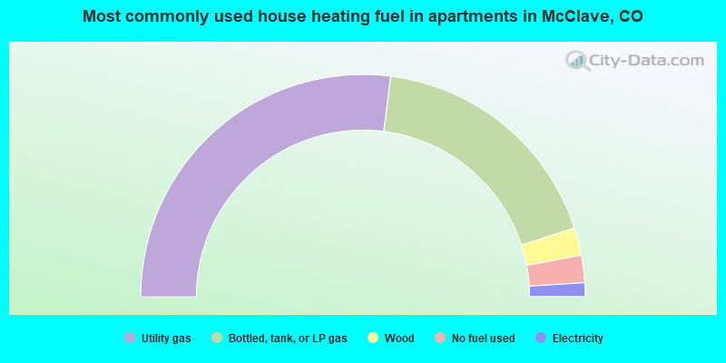
- 54.0%Utility gas
- 36.0%Bottled, tank, or LP gas
- 4.0%Wood
- 4.0%No fuel used
- 2.0%Electricity
McClave compared to Colorado state average:
- Median household income below state average.
- Median house value significantly below state average.
- Unemployed percentage significantly below state average.
- Black race population percentage significantly below state average.
- Foreign-born population percentage significantly below state average.
- Length of stay since moving in significantly above state average.
- Number of rooms per house significantly below state average.
- House age significantly below state average.
- Percentage of population with a bachelor's degree or higher below state average.