Estimated median house or condo value in 2022: $185,225 (it was $100,500 in 2000)
Mayville:
$185,225
WI:
$252,800
Mean prices in 2022:all housing units: $261,408; detached houses: $272,121; townhouses or other attached units: $256,767; in 2-unit structures: $201,412; in 3-to-4-unit structures: $189,678; in 5-or-more-unit structures: $177,084; mobile homes: $51,673
Median gross rent in 2022: $779.
March 2022 cost of living index in Mayville: 77.1 (low, U.S. average is 100)
According to our research of Wisconsin and other state lists, there were 8 registered sex offenders living in Mayville, Wisconsin as of May 11, 2024. The ratio of all residents to sex offenders in Mayville is 630 to 1. The ratio of registered sex offenders to all residents in this city is lower than the state average.
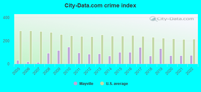
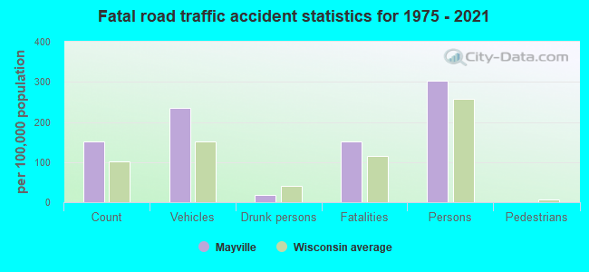
Crime rates in Mayville by year
Type
2009
2010
2011
2012
2013
2014
2015
2016
2017
2018
2019
2020
2021
2022
Murders (per 100,000)
0 (0.0)
0 (0.0)
0 (0.0)
0 (0.0)
0 (0.0)
0 (0.0)
0 (0.0)
0 (0.0)
0 (0.0)
0 (0.0)
1 (20.6)
0 (0.0)
0 (0.0)
0 (0.0)
Rapes (per 100,000)
1 (19.6)
1 (19.4)
0 (0.0)
0 (0.0)
1 (19.7)
1 (19.9)
1 (20.1)
1 (20.2)
3 (61.1)
1 (20.6)
1 (20.6)
1 (20.6)
2 (41.7)
2 (39.0)
Robberies (per 100,000)
0 (0.0)
0 (0.0)
0 (0.0)
0 (0.0)
0 (0.0)
0 (0.0)
2 (40.2)
0 (0.0)
1 (20.4)
1 (20.6)
0 (0.0)
0 (0.0)
0 (0.0)
0 (0.0)
Assaults (per 100,000)
4 (78.3)
2 (38.8)
1 (19.3)
1 (19.4)
0 (0.0)
0 (0.0)
0 (0.0)
5 (100.8)
6 (122.3)
0 (0.0)
6 (123.5)
6 (123.4)
4 (83.4)
2 (39.0)
Burglaries (per 100,000)
8 (156.6)
15 (291.0)
17 (328.4)
12 (232.6)
12 (236.4)
7 (139.1)
8 (160.8)
11 (221.9)
1 (20.4)
4 (82.3)
1 (20.6)
2 (41.1)
0 (0.0)
0 (0.0)
Thefts (per 100,000)
97 (1,899)
133 (2,581)
88 (1,700)
83 (1,609)
67 (1,320)
54 (1,073)
75 (1,508)
60 (1,210)
67 (1,365)
42 (863.8)
48 (987.9)
31 (637.6)
28 (583.6)
45 (878.2)
Auto thefts (per 100,000)
0 (0.0)
0 (0.0)
0 (0.0)
1 (19.4)
1 (19.7)
1 (19.9)
1 (20.1)
0 (0.0)
5 (101.9)
4 (82.3)
5 (102.9)
1 (20.6)
0 (0.0)
0 (0.0)
Arson (per 100,000)
0 (0.0)
0 (0.0)
0 (0.0)
0 (0.0)
0 (0.0)
1 (19.9)
0 (0.0)
0 (0.0)
0 (0.0)
1 (20.6)
0 (0.0)
0 (0.0)
0 (0.0)
1 (19.5)
City-Data.com crime index
118.3
146.9
94.9
86.1
86.7
70.1
101.3
100.2
143.7
69.5
131.5
71.2
73.4
74.2
The City-Data.com crime index weighs serious crimes and violent crimes more heavily. Higher means more crime, U.S. average is 246.1. It adjusts for the number of visitors and daily workers commuting into cities.
Latest news from Mayville, WI collected exclusively by city-data.com from local newspapers, TV, and radio stations
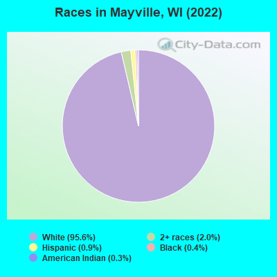
Ancestries: German (74.6%), European (6.0%), American (4.3%), Polish (3.6%), English (1.3%), Irish (1.1%).
Current Local Time: CST time zone
Incorporated in 1885
Elevation: 950 feet
Land area: 3.11 square miles.
Population density: 1,657 people per square mile (low).
53 residents are foreign born
This city:
1.0%
Wisconsin:
5.0%
Median real estate property taxes paid for housing units with mortgages in 2022: $2,947 (1.5%) Median real estate property taxes paid for housing units with no mortgage in 2022: $3,097 (1.7%)
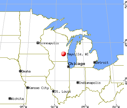
Nearest city with pop. 50,000+: Oshkosh, WI (36.5 miles , pop. 62,916).
Nearest city with pop. 200,000+: Milwaukee, WI (42.8 miles , pop. 596,974).
Nearest city with pop. 1,000,000+: Chicago, IL (122.8 miles , pop. 2,896,016).
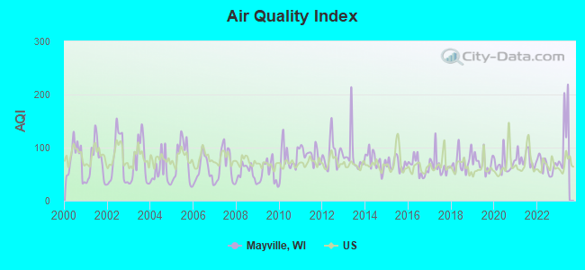
Air Quality Index (AQI) level in 2022 was 66.1. This is about average.
City:
66.1
U.S.:
72.6
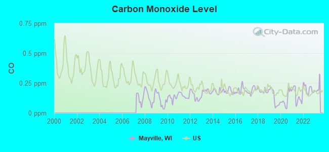
Carbon Monoxide (CO) [ppm] level in 2022 was 0.198. This is better than average.Closest monitor was 4.3 miles away from the city center.
City:
0.198
U.S.:
0.251
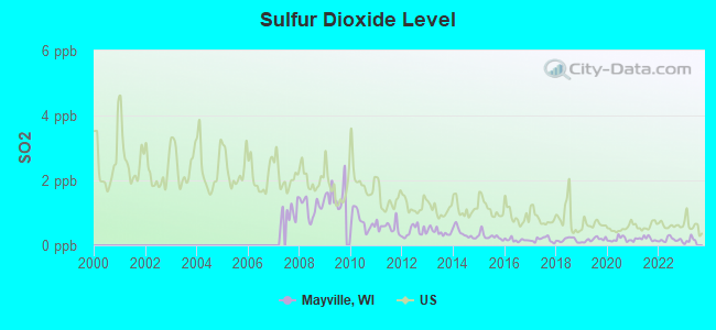
Sulfur Dioxide (SO2) [ppb] level in 2022 was 0.173. This is significantly better than average.Closest monitor was 1.2 miles away from the city center.
City:
0.173
U.S.:
1.515
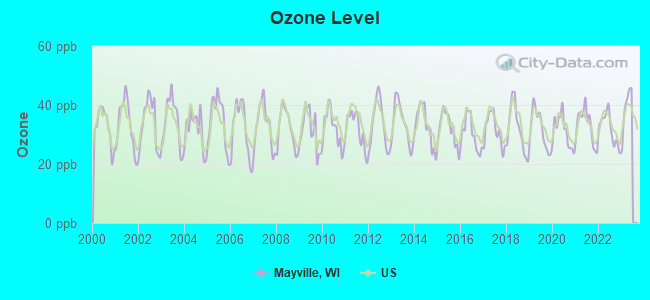
Ozone [ppb] level in 2022 was 31.9. This is about average.Closest monitor was 4.3 miles away from the city center.
City:
31.9
U.S.:
33.3
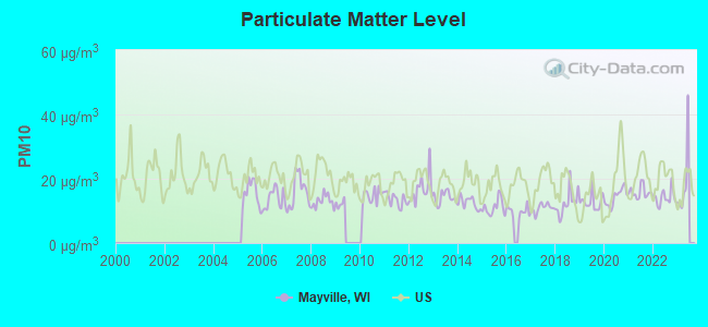
Particulate Matter (PM10) [µg/m3] level in 2022 was 14.1. This is better than average.Closest monitor was 4.3 miles away from the city center.
City:
14.1
U.S.:
19.2
Particulate Matter (PM2.5) [µg/m3] level in 2022 was 7.50. This is about average.Closest monitor was 4.3 miles away from the city center.
City:
7.50
U.S.:
8.11
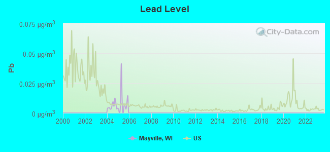
Lead (Pb) [µg/m3] level in 2005 was 0.0105. This is about average.Closest monitor was 4.4 miles away from the city center.
City:
0.0105
U.S.:
0.0093
Tornado activity:
Mayville-area historical tornado activity is slightly above Wisconsin state average. It is 59% greater than the overall U.S. average.
On 7/18/1996, a category F5 (max. wind speeds 261-318 mph) tornado 14.5 miles away from the Mayville city center injured 12 peopleand caused $40 million in damages.
On 4/4/1981, a category F4 (max. wind speeds 207-260 mph) tornado 18.1 miles away from the city center killed 3 peopleand injured 53 peopleand causedbetween $5,000,000 and $50,000,000 in damages.
Earthquake activity:
Mayville-area historical earthquake activity is significantly above Wisconsin state average. It is 9% greater than the overall U.S. average.
On 4/18/2008 at 09:36:59, a magnitude 5.4 (5.1 MB, 4.8 MS, 5.4 MW, 5.2 MW, Class: Moderate, Intensity: VI - VII) earthquake occurred 350.7 miles away from Mayville center On 6/28/2004 at 06:10:52, a magnitude 4.2 (4.2 MW, Depth: 6.2 mi, Class: Light, Intensity: IV - V) earthquake occurred 142.0 miles away from the city center On 6/10/1987 at 23:48:54, a magnitude 5.1 (4.9 MB, 4.4 MS, 4.6 MS, 5.1 LG) earthquake occurred 325.3 miles away from Mayville center On 4/18/2008 at 09:36:59, a magnitude 5.2 (5.2 MW, Depth: 8.9 mi) earthquake occurred 350.7 miles away from the city center On 5/2/2015 at 16:23:07, a magnitude 4.2 (4.2 MW, Depth: 2.8 mi) earthquake occurred 180.6 miles away from the city center On 2/10/2010 at 09:59:35, a magnitude 3.8 (3.8 MW, Depth: 6.2 mi, Class: Light, Intensity: II - III) earthquake occurred 105.7 miles away from Mayville center Magnitude types: regional Lg-wave magnitude (LG), body-wave magnitude (MB), surface-wave magnitude (MS), moment magnitude (MW)
Natural disasters:
The number of natural disasters in Dodge County (12) is smaller than the US average (15). Major Disasters (Presidential) Declared: 9 Emergencies Declared: 3
Causes of natural disasters: Floods: 6, Storms: 6, Tornadoes: 4, Drought: 1, Hurricane: 1, Snow: 1, Snowstorm: 1, Wind: 1, Winter Storm: 1, Other: 1 (Note: some incidents may be assigned to more than one category).
Hospitals and medical centers in Mayville:
MAYVILLE NUR REHAB CTR (305 S CLARK ST)
Other hospitals and medical centers near Mayville:
HOPE HEALTH AND REHAB (Nursing Home, about 9 miles away; LOMIRA, WI)
HOPE NURSING HOME INC (Nursing Home, about 9 miles away; LOMIRA, WI)
DODGE COUNTY MENTAL HEALTH CENTER (Hospital, about 10 miles away; JUNEAU, WI)
CLEARVIEW (Nursing Home, about 10 miles away; JUNEAU, WI)
CHRISTIAN HOME (Nursing Home, about 14 miles away; WAUPUN, WI)
CHRISTIAN HOME AND REHAB CTR (Nursing Home, about 14 miles away; WAUPUN, WI)
WAUPUN MEM HSPTL Critical Access Hospitals (about 14 miles away; WAUPUN, WI)
Amtrak station near Mayville:
19 miles: FONT DU LAC (FOND DU LAC, 24 W. PIONEER RD.) - Bus Station
MAYVILLE PUBLIC LIBRARY (Operating income: $218,403; Location: 111 N. MAIN ST.; 48,542 books; 8,825 e-books; 6,038 audio materials; 2,924 video materials; 1 local licensed databases; 28 state licensed databases; 114 print serial subscriptions)
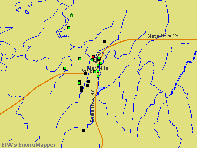
Notable locations in Mayville: Mayville Golf Club (A), Mayville Ambulance Service (B), Mayville Volunteer Fire Department (C), Mayville Public Library (D), Mayville City Hall (E). Display/hide their locations on the map
Churches in Mayville include: Christian Life Fellowship Church (A), Saint Pauls Evangelical Lutheran Church (B), Saint Marys Catholic Church (C), Saint Johns Lutheran Church (D). Display/hide their locations on the map
Cemeteries: Graceland Cemetery (1), New Saint Marys Cemetery (2), Old Saint Marys Cemetery (3), Saint Johns Cemetery (4). Display/hide their locations on the map
Parks in Mayville include: Ewald Park (1), Firemans Park (2), Foster Park (3), Lions Point Playground (4), Malt House Playgrounds (5), Ribbens Memorial Park (6), Zeigler Park (7). Display/hide their locations on the map
Tourist attractions: Mayville Historical Society (Cultural Attractions- Events- & Facilities; 11 North German Street), I M S Technology (Amusement & Theme Parks; N10127 County Road V).
Hotel: Mayville Inn Motel (701 Mountin Drive).
Dodge County has a predicted average indoor radon screening level greater than 4 pCi/L (pico curies per liter) - Highest Potential
Drinking water stations with addresses in Mayville and their reported violations in the past:
MARSH INN (Population served: 97, Groundwater):
Past monitoring violations:
One routine major monitoring violation
U S F W S HORICON COMFORT STATION (Address: W4279 HEADQUARTERS RD , Population served: 50, Groundwater):
Past health violations:
MCL, Monthly (TCR) - In SEP-2013, Contaminant: Coliform. Follow-up actions: St Public Notif requested (SEP-11-2013), St Boil Water Order (SEP-11-2013), St Violation/Reminder Notice (SEP-11-2013), St Public Notif received (SEP-12-2013), St Compliance achieved (NOV-11-2013)
MAYVILLE CITY ZIEGLER PARK (Population served: 50, Groundwater):
Past health violations:
MCL, Monthly (TCR) - In APR-2009, Contaminant: Coliform. Follow-up actions: St Violation/Reminder Notice (MAY-06-2009), St Public Notif requested (MAY-06-2009), St Boil Water Order (MAY-06-2009), St Compliance achieved (MAY-21-2009), St Public Notif received (MAY-21-2009)
Drinking water stations with addresses in Mayville that have no violations reported:
U S F W S HORICON HDQRTS BLDG (Address: W4279 HEADQUARTERS RD , Population served: 110,Primary Water Source Type: Groundwater)
ST PETERS EVANGELICAL LUTHERAN CHURCH (Population served: 88,Primary Water Source Type: Groundwater)
MAYVILLE LIMESTONE INC (Population served: 30,Primary Water Source Type: Groundwater)
Average household size:
This city:
2.3 people
Wisconsin:
2.4 people
Percentage of family households:
This city:
64.7%
Whole state:
64.4%
Percentage of households with unmarried partners:
This city:
7.4%
Whole state:
7.3%
Likely homosexual households (counted as self-reported same-sex unmarried-partner households)
Lesbian couples: 0.1% of all households
Gay men: 0.0% of all households
93 people in nursing facilities/skilled-nursing facilities in 2010
4 people in group homes intended for adults in 2010
78 people in nursing homes in 2000
12 people in other noninstitutional group quarters in 2000
Banks with branches in Mayville (2011 data):
Mayville Savings Bank: at 200 South Main Street, branch established on 1922/01/01. Info updated 2006/11/03: Bank assets: $56.7 mil, Deposits: $47.2 mil, local headquarters, positive income, Mortgage Lending Specialization, 1 total offices
M&I Bank of Mayville: M&I Bank Of Mayville at 209 Horicon Street, branch established on 2001/05/17. Info updated 2006/11/03: Bank assets: $3.0 mil, Deposits: $0.5 mil, local headquarters, positive income, 1 total offices, Holding Company: Bank Of Montreal
TSB Bank: Mayville Branch at 935 Horicon St., branch established on 1999/07/06. Info updated 2006/11/03: Bank assets: $92.1 mil, Deposits: $80.4 mil, headquarters in Lomira, WI, positive income, Commercial Lending Specialization, 3 total offices
BMO Harris Bank National Association: Mayville Branch at 209 Horicon Street, branch established on 1892/11/01. Info updated 2011/07/14: Bank assets: $97,264.0 mil, Deposits: $75,624.6 mil, headquarters in Chicago, IL, positive income, 717 total offices, Holding Company: Bank Of Montreal
Horicon Bank: Mayville Branch at 1440 Horicon Street, branch established on 2003/11/10. Info updated 2011/09/21: Bank assets: $506.5 mil, Deposits: $440.0 mil, headquarters in Horicon, WI, positive income, Commercial Lending Specialization, 15 total offices, Holding Company: Sword Financial Corporation
American Bank: Mayville Branch at 1802 Horicon Street, branch established on 1998/07/20. Info updated 2006/11/03: Bank assets: $228.4 mil, Deposits: $169.8 mil, headquarters in Fond Du Lac, WI, positive income, Commercial Lending Specialization, 5 total offices, Holding Company: Neb Corporation
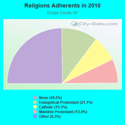
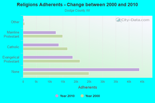
Religion statistics for Mayville, WI (based on Dodge County data)
Religion
Adherents
Congregations
Evangelical Protestant
18,757
62
Catholic
13,437
13
Mainline Protestant
12,363
32
Other
265
2
Orthodox
-
-
None
43,937
-
Source: Clifford Grammich, Kirk Hadaway, Richard Houseal, Dale E.Jones, Alexei Krindatch, Richie Stanley and Richard H.Taylor. 2012. 2010 U.S.Religion Census: Religious Congregations & Membership Study. Association of Statisticians of American Religious Bodies. Jones, Dale E., et al. 2002. Congregations and Membership in the United States 2000. Nashville, TN: Glenmary Research Center. Graphs represent county-level data
WMDC Studio, 132 North Main Street (Lat: 43.497222 Lon: -88.545944), Type: Tower, Structure height: 10 m, Call Sign: WPUU989, Licensee ID: L00138332, Assigned Frequencies: 946.000 MHz, Grant Date: 05/08/2002, Expiration Date: 12/01/2028, Certifier: Mike Enfelt, Registrant: Radio Plus, Inc.
SPRINGBROOK, N7890 Cty V (Lat: 43.478889 Lon: -88.552639), Type: Pole, Structure height: 30.4 m, Overall height: 35 m, Call Sign: WQPB203, Assigned Frequencies: 928.381 MHz, 952.381 MHz, Grant Date: 03/26/2012, Expiration Date: 03/26/2022, Cancellation Date: 09/17/2013, Certifier: James Teach, Registrant: Spectrum And Licensing Services, 11 Lee Street, Hanover, PA 17331, Phone: (717) 630-0816, Fax: (717) 637-8300
DT MAYVILLE, 55 West Slag Road (Lat: 43.515194 Lon: -88.542778), Type: Gtower, Structure height: 54.9 m, Overall height: 59.4 m, Call Sign: WQUH999, Assigned Frequencies: 6078.62 MHz, Grant Date: 07/15/2014, Expiration Date: 07/15/2024, Certifier: Steven T Campbell, Registrant: Wilkinson Barker Knauer, LLP, 1800 M Street Nw, Suite 800n, Washington, DC 20036, Phone: (202) 383-3420, Fax: (202) 783-5851, Email:
Aircraft: PIPER PA-18-150 (Category: Land, Seats: 2, Weight: Up to 12,499 Pounds, Speed: 97 mph), Engine: LYCOMING 0-320 SERIES (180 HP) (Reciprocating) N-Number: 4496Z, N4496Z, N-4496Z, Serial Number: 18-8851, Year manufactured: 1969, Airworthiness Date: 10/03/1969, Certificate Issue Date: 03/07/2016 Registrant (Individual): Rodney L Barnes, 1026 Horicon St, Mayville, WI 53050
Aircraft: HUGHES MICHAEL J/HUGHES MARK C GLASAIR 1FT (Category: Land, Seats: 2, Weight: Up to 12,499 Pounds), Engine: LYCOMING O-320-E2A (150 HP) (Reciprocating) N-Number: 471MH, N471MH, N-471MH, Serial Number: 767, Year manufactured: 2020, Airworthiness Date: 09/01/2020, Certificate Issue Date: 12/19/2019 Registrant (Co-Owned): Michael J Hughes, N8144 State Road 28, Mayville, WI 53050, Other Owners: Mark C Hughes
Aircraft: TAYLORCRAFT DCO-65 (Category: Land, Seats: 2, Weight: Up to 12,499 Pounds, Speed: 82 mph), Engine: CONT MOTOR A&C65 SERIES (65 HP) (Reciprocating) N-Number: 53755, N53755, N-53755, Serial Number: 5902, Year manufactured: 1944 Registrant (Individual): Tony Krutke, 45 N Main, Mayville, WI 53050 Deregistered:Cancel Date: 04/05/2018
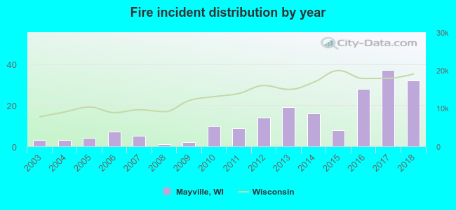
2003 - 2018 National Fire Incident Reporting System (NFIRS) incidents
Based on the data from the years 2003 - 2018 the average number of fire incidents per year is 12. The highest number of fires - 37 took place in 2017, and the least - 1 in 2008. The data has an increasing trend.
When looking into fire subcategories, the most incidents belonged to: Structure Fires (42.4%), and Outside Fires (27.8%).
Fire incident types reported to NFIRS in Mayville, WI
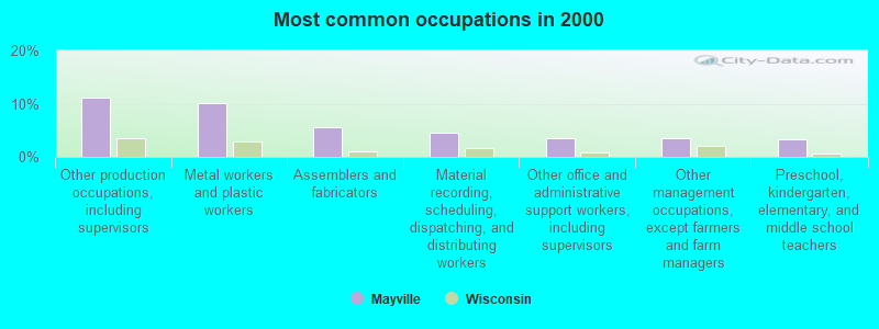
#9 on the list of "Top 101 cities with largest percentage of males in occupations: production occupations (population 5,000+)"
#15 on the list of "Top 101 cities with the smallest percentage of likely homosexual households (counted as self-reported same-sex unmarried-partner households) (population 5,000+)"
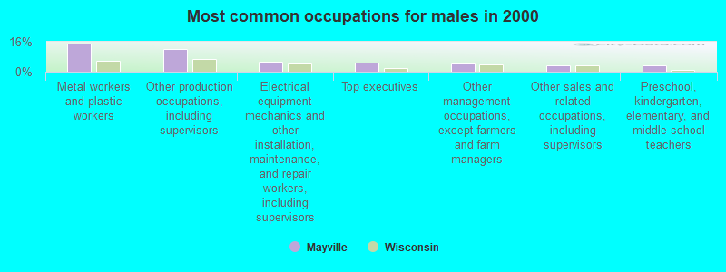
#15 on the list of "Top 101 cities with largest percentage of males in industries: manufacturing (population 5,000+)"
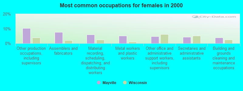
#19 on the list of "Top 101 cities with largest percentage of females in industries: manufacturing (population 5,000+)"
#90 on the list of "Top 101 cities with the most people born in the same U.S. state as the city (population 5,000+)"
#6 (53050) on the list of "Top 101 zip codes with the largest percentage of German first ancestries (pop 5,000+)"
#53 on the list of "Top 101 counties with the lowest Sulfur Oxides Annual air pollution readings in 2012 (µg/m3)"
#69 on the list of "Top 101 counties with the largest number of children under 18 without health insurance coverage in 2000 (pop. 50,000+)"
#73 on the list of "Top 101 counties with the largest number of people without health insurance coverage in 2000 (pop. 50,000+)"


 Recent articles from our blog. Our writers, many of them Ph.D. graduates or candidates, create easy-to-read articles on a wide variety of topics.

 (36.5 miles
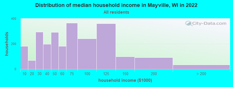


 Based on the data from the years 2003 - 2018 the average number of fire incidents per year is 12. The highest number of fires - 37 took place in 2017, and the least - 1 in 2008. The data has an increasing trend.
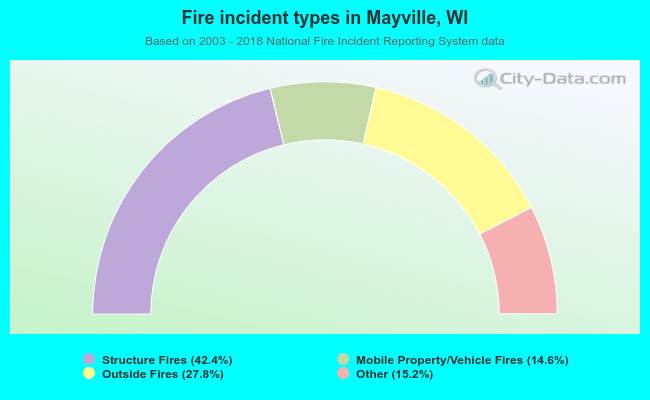 When looking into fire subcategories, the most incidents belonged to: Structure Fires (42.4%), and Outside Fires (27.8%).